Dilution of Salinity Using Rainwater Harvesting System - An Innovative Approach
Kulsum Fatima
*

1
Department of Architecture,
Jamia Millia Islamia,
Jamia Nagar,
New Delhi
India
http://dx.doi.org/10.12944/CWE.18.3.26
Copy the following to cite this article:
Fatima K. Dilution of Salinity Using Rainwater Harvesting System - An Innovative Approach. Curr World Environ 2023;18(3). DOI:http://dx.doi.org/10.12944/CWE.18.3.26
Copy the following to cite this URL:
Fatima K. Dilution of Salinity Using Rainwater Harvesting System - An Innovative Approach. Curr World Environ 2023;18(3).
Download article (pdf) Citation Manager Publish History

Introduction
Delhi's Union Territory is characterized by a flat, level landscape interrupted by clusters of sand dunes and continuous chains of rocky ridges.1 Salinity hazards are prevalent in New Delhi and its surroundings areas due to excessive sodium, calcium, magnesium, and chlorine concentrations.2 The combination of arid conditions with the summer season causes fine pores in silt clay to act as capillaries to lift water from the shallow water table. This water evaporation leads to salt precipitation in the near surface soil and groundwater. During the literature review, multiple surface and subsurface data were evaluated and revealed a typical set-up susceptible to salinity hazards as a result of geomorphic, lithological, and climatic factors.2 Salinity is defined as “the accumulation of salts above certain levels in water or soil matrix and geological formation”.3 Increase in salinity day by day, requires urgent management of water resource management in salinity affected areas.4 The saline character has both “direct and indirect effects on human well-being”.5 As per Kumar et al. (2008), groundwater salinity in the NCT region is classified as fresh, freshening, near-freshening, and saline.6 These fresh and freshening groundwater areas have been deemed safe to drink and use for domestic purposes. While in saline areas the groundwater is considered unsuitable for drinking and domestic purposes. In view of the increasing water demand, the recent study focuses on delineating these saline areas in Delhi. It identifies rainwater harvesting potential as an innovative approach for salinity dilution.
Description of the site
Delhi is largely dominated by the presence of Yamuna and its flood plains, which originated due to major tectonic activities creating three types of deposits on this river: the channel deposits, the floodplain deposits and the back-swamp deposits.
The channel deposit contains coarse green particles like sand and gravel which have high permeable and porous conditions. As a result, groundwater, which is a part of rainwater, remains fresh due to high porosity and high permeability. This type of areas is designated as freshwater zones.
The floodplain deposits contain alternate beds of clay and sand. This is because in the lean period, the area contains fine grain particles like clay and silt and during the peak the area contains sand and gravel. As a result, the alternate strata of clay and sand is encountered. In this type of deposit where there is fine grain particle, this aligns water originate because the fine grain particle has high porosity and low permeability. Because of these non-flushing conditions, the area develops salinity, which transmits from top to bottom, causing freshwaters to become salty due to intermixing.
However, in the case of the back-swamp deposit it contains only fine grain particles like clay and silt, resulting in the formation of the saline zone. These are the basic causes of salinity development along the Yamuna riverbed plain. The cause of salinity is continuous evaporation where water vapour evaporates and salt remains which increases day by day, resulting in increased salinity.
Physiographic division of Delhi
In parts of Delhi, salinity is a natural phenomenon owing to its physiographic situation. The eastern part of Delhi is covered by Yamuna alluvium and the Yamuna River has depressions due to non-return of overflow water from its peak period which remains in the depression areas. The western part of Delhi is influenced by Delhi Ridge, resulting in multiple depressions, such as Najafgarh Jheel in the western region. The northern part of Delhi including the areas of Narayana Punjabi Bagh etc, has got the back-swamp deposits and depression zones, as a result many locations have developed salinity. The southern part of Delhi from Mehrauli to Yamuna River area exhibits limited local depressions and is comparatively low salinity area. As a result, comparatively low saline areas have been demarcated and have saline patches. Mostly the rocky areas in this part are occupied by the fresh waters. Whereas, the central part of the Delhi region has got comparatively very low salinity because of the occurrence of freshwater due to boundary conditions created by the southern and northern rich areas.
Objectives & Scope of the Study
In order to evaluate the salinity scenario in NCT Delhi, the following objectives are identified for this study
Delineation of the salinity in part of NCT Delhi
Finding the causes of salinity in parts of NCT Delhi
Delineation of dynamics of salinity in parts of Delhi
Analysis of impact assessment of RWH on dilution of salinity
Methods and Materials
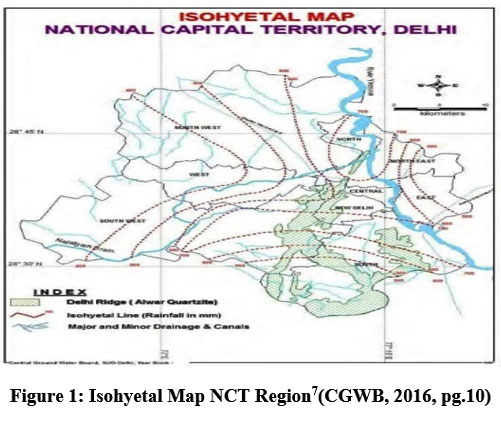
According to central ground water report 2016,7 stations were identified from the description and narration of the Isohytal map shown in Figure 1, the Water level fluctuation map shown in Figure 2, and the depth-to-water level map shown in Figure 3. An overlay exercise for these maps is done to provide an assessment of the data. The saline regions are identified with a range of <2m upto 5m range of depth to water level data. The stations identified in this range are further assessed with respect to the identified isohyet values of 350, 375, 450, 600, 700 and 650 respectively. Additionally, the rainwater harvesting potential as per central ground water board calculations is calculated for a roof top area of 100, 200, 300, 400 and 500 square meters. This is done to predict the possibilities for rainwater collection at the identified saline zone stations. This assessment will help to predict and understand the extent of salinity dilution in the selected saline zones of NCT, Delhi.
 | Figure 1: Isohyetal Map NCT Region7(CGWB, 2016, pg.10)
|
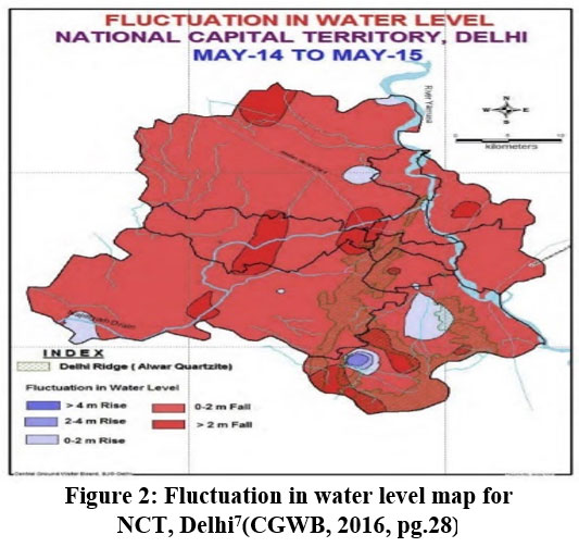 | Figure 2: Fluctuation in water level map for NCT, Delhi7(CGWB, 2016, pg.28) |
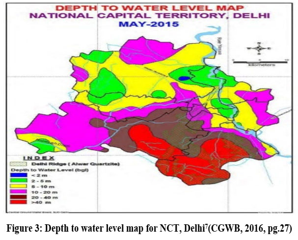 | Figure 3: Depth to water level map for NCT, Delhi7(CGWB, 2016, pg.27)
|
Analysis and Discussion
This section presents the analysis and discussions around the objectives identified n section2 of this paper, including: delineation of the salinity, causes of salinity, delineation of dynamics of salinity, and the impact assessment of RWH on dilution of salinity. Each of these are discussed in detail as follows:
Delineation of the salinity in part of NCT Delhi
In order to delineate the salinity in parts of the city of Delhi, the Central Ground Water Board report (2016), has been considered to identify, analyse, and select the salinity monitoring stations. As per this report, the regions in Delhi, including the Rohini Region, Ghazipur region, Ghevra Village region, Bazidpur region, Badarpur region and central region are selected based on this analysis. The salinity of these regions was analysed with water sampling collected from shallow tube wells ranging in the depth of 45-60 metres. The results are as follows:
Table 1: Salinity of selected regions in Delhi
| Stations | Depth to water level | TDS (mg/litre) |
1 | Ghazipur region | 2-5 m | 4300 |
2 | Ghevra Village region | 2-5 m | 3200 |
3 | Bazidpur region | 2-5 m | 2700 |
4 | Rohini Region | <2 m | 5200 |
5 | Badarpur region | 2-5 m | 3700 |
6 | central region | 2-5 m | 1700 |
The salinity curve is represented in Figure 5 (below) shows a cynocidal character and was recorded at 4300 at Ghazipur followed by a low in Ghevra and Bazidpur regions. The highest of 5200 is reached in Rohini region after which it drops to 3700 in Badarpur region. This is followed by the lowest in central region at 1700 (mg/litre) TDS value. On average, these values indicate that there is no uniformity of salinity concentration in shallow ground water aquifers. However, the ground water flow direction was recorded towards the Yamuna River. The main reason for this salinity syndrome may be identified in depression areas which are mainly responsible for the concentration of high TDS. This is where the aquiclude materials like clay have been deposited which is highly porous and low permeable. Since the evaporation rate in Delhi depends on temperature and winds direction, these depressions show high concentrations of TDS which may be diluted using RWH potential.
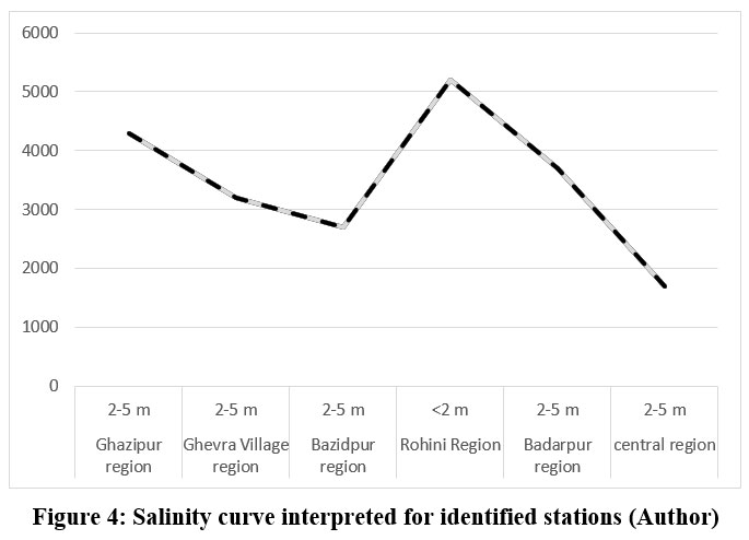 | Figure 4: Salinity curve interpreted for identified stations (Author).
|
Finding the causes of salinity in parts of NCT Delhi
The high rate of evaporation and the clay soil in the low-lying area are the main reasons for saline water. These areas belong to back swamp deposits, which can be described physiologically as degradation areas, which are shown in the Figure 6 below. This map has been created by overlaying the political boundaries map of Delhi8over the depth to water level map of NCT, Delhi provided by central ground water board (2016), pg.27.7As a result, saline regions are highlighted under green and blue regions. This overlay figure helps to identify the physical locations of areas including Rohini Region, Ghazipur region, Ghevra Village region, Bazidpur region, Badarpur region and the central region of NCT, Delhi. Blue and green zones are clay deposits that have high evaporation and are characterized by high salinity. As a result of clay deposits in these zones, the water fluctuation levels are at a minimum, as per the Central Ground Water Board report (2016).7
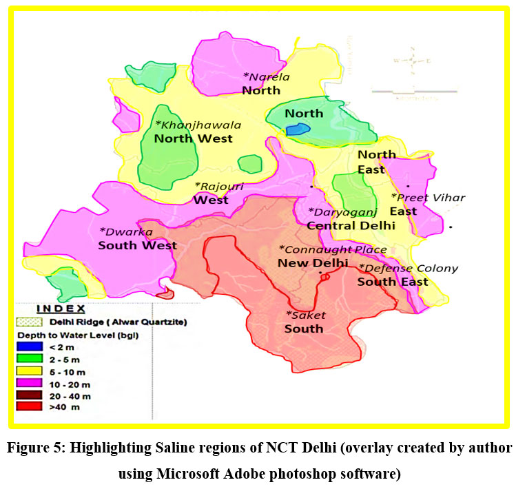 | Figure 5: Highlighting Saline regions of NCT Delhi (overlay created by author using Microsoft Adobe photoshop software).
|
Delineation of dynamics of salinity in parts of Delhi
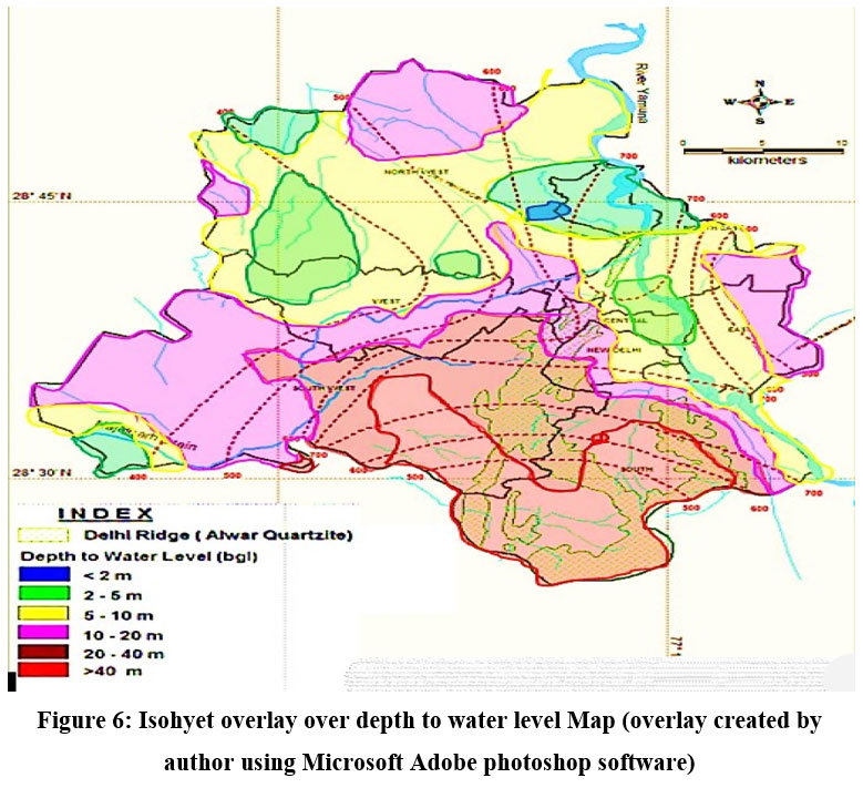
Figure 6 shows Isohyetal map7 overlaid on depth-to-water level map based on Central ground water board report. The central part of Delhi including India gate, Chanakyapuri area and mainly the New Delhi Municipal Committee (NDMC) areas has good rainwater harvesting potential. While the western and southwestern parts of Delhi have low rainwater potential. Other regions like Jamia Nagar have a moderate rainwater potential. The isohyet’s analysis further indicates that the respective potential for the dilution of salinity can be analysed through the following curves represented in figure 7.
 | Figure 6: Isohyet overlay over depth to water level Map (overlay created by author using Microsoft Adobe photoshop software).
|
According to lithological analysis, Delhi's rocky areas, such as Mehrauli, have fresh water while its peripheral areas, near Yamuna riverbank and Najafgarh drain, have high salinity. This may be interpreted as the impact of physiographic units on ground water quality due to limited transmissibility and low duration stagnant conditions. This lowers the concentration of the total dissolved solids (TDS) in higher regimes like Qutub Minar and Mehrauli region. Salinity becomes high towards low-lying areas. Since the ground water and surface water move from higher topography to lower topography which helps us interpret that the higher topographical area in Delhi has a freshwater regime. However, the depression areas have a saline water system, which may be interpreted as the hydrodynamics of the ground water movement vis-à-vis salinity.
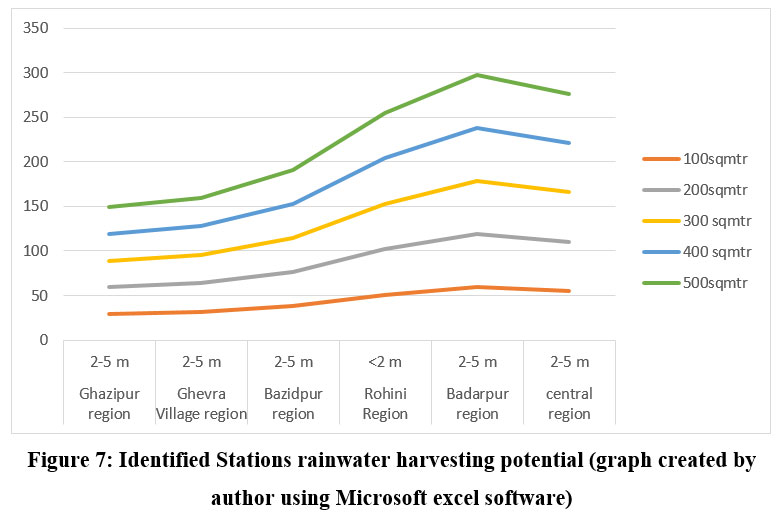 | Figure 7: Identified Stations rainwater harvesting potential (graph created by author using Microsoft excel software).
|
Analysis of impact assessment of RWH on dilution of salinity
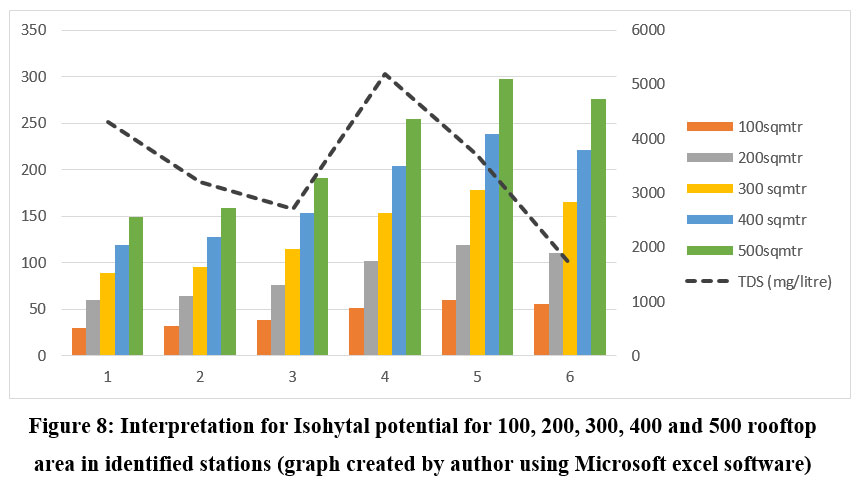
Using the isohytal map of Delhi on selected stations, an experimental study was conducted to determine the impact of rainwater potential on groundwater salinity. The development of a model of isohytal potential for 100, 200, 300, 400 and 500 square meters roof top area, which is shown in the following graph Figure 8 (below). The results have shown that the available RWH potential and recharge of ground water at the given stations where the TDS value has been recorded are as follows:
 | Figure 8: Interpretation for Isohytal potential for 100, 200, 300, 400 and 500 rooftop area in identified stations (graph created by author using Microsoft excel software)
|
Table 2: Rainwater potential for identified stations (Table created by author using Microsoft excel software).
| Station/location | Depth to water level | Isohyets (i) | Q=ciA (RW potential) cubic metre | ||||
|
|
|
| 100sqmtr | 200sqmtr | 300 sqmtr | 400 sqmtr | 500sqmtr |
| 1 | Ghazipur region | 2-5 m | 350 | 29.75 | 59.5 | 89.25 | 119 | 148.75 |
| 2 | Ghevra Village region | 2-5 m | 375 | 31.875 | 63.75 | 95.625 | 127.5 | 159.375 |
| 3 | Bazidpur region | 2-5 m | 450 | 38.25 | 76.5 | 114.75 | 153 | 191.25 |
| 4 | Rohini Region | <2 m | 600 | 51 | 102 | 153 | 204 | 255 |
| 5 | Badarpur region | 2-5 m | 700 | 59.5 | 119 | 178.5 | 238 | 297.5 |
| 6 | central region | 2-5 m | 650 | 55.25 | 110.5 | 165.75 | 221 | 276.25 |
Since, the RW potential and depth to water level map along with water level fluctuations indicate that there are lots of variations. Therefore, it is important to study the impact assessment on the dilution of salinity in these areas, with variable values of RW potential and total dissolved solids (TDS). It is obvious that wherever the potential is higher, and TDS is low like in the central region, the impact of ground water recharge will be very effective. Secondly, where the rainwater (RW) potential is higher, and the TDS value is medium Ghazipur and Badarpur regions will be taken as second effective zones for salinity dilution. The third type of station may be taken as high salinity with low rainwater potential zones in an area like Rohini. From the above study it is recommended that efforts should be made in the Rohini region to dilute salinity for the normal functioning of water appliances and instruments. These efforts are also suggested to reduce salinity's direct and indirect effects on human health and well being. Especially since salinity intrusion into drinking water can lead to increased blood pressure (BP) or hypertension, which in turn can lead to cardiovascular diseases (CVD). Additionally, both male and female adults have been found to suffer from hypertension and stroke when living in high salinity areas.9 As a result, rainwater harvesting is considered a sustainable solution in salt-affected regions for improving surface water and groundwater management..10,11,12Another way to reduce salinity includes planting salt-tolerant grasses, herbs, shrubs, trees, adding gypsum and fertilizers to encourage plant growth, and preventing erosion by using contour banks to divert surface water away from the property. This leads to a strategic approach to combat water scarcity, especially the deterioration of ground water quality by using rainwater harvesting.13
Conclusion and recommendations
In order to study the impact assessment of the rainwater harvesting system on the dilution of salinity, different maps and data were analysed. These maps included a salinity map of Delhi, depth-to-water level map of Delhi, water level fluctuation map of Delhi, isohytal map of Delhi, etc. And it was concluded that the aggradation areas of Delhi like the Mehrauli region have a freshwater regime whereas the low-lying areas in Delhi are mostly affected by salinity. These areas are occupied by back swamp deposits. It may be concluded that Delhi's rainwater potential and salinity areas have no correlation. This is because the higher RW potential doesn’t show major dilution of salinity of the freshwater regime. However, the fresh water comes from Mehrauli region which is a rocky area, where the geochemistry of rocks indicates clearly that the rainwater doesn’t react with the lithology. Therefore, it remains fresh with medium to high rainwater potential and falls under depression areas, which doesn't dilute the salinity in its natural course. As a consequence, it is recommended that artificial recharging of ground water using an RWH technique will reduce salinity levels. This is because RW's infiltration potential will increase dramatically compared to natural infiltration. This is due to the fact that rainwater has a higher infiltration rate than groundwater. This means it can more easily penetrate the soil and reach the aquifer. Since these areas identified in Delhi are already prone to depression, the higher infiltration potential of RWH compared to natural infiltration, will help more water get absorbed by the ground. Additionally, rainwater is usually lower in salinity than groundwater, which reduces salinity levels in the aquifer.
Acknowledgements
The author would like to thank everyone who has supported in this quest, including the researchers whose research papers were used as a source for the current study and are referenced in this research paper.
Conflict of Interest
There is no conflict of interest
Funding Sources
There is no funding or financial support for this work.
References
- About Delhi. Rainwaterharvesting.org. Published 2011. http://www.rainwaterharvesting.org/index_files/about_delhi.htm
- Priyadarshi DN. Why New Delhi’s groundwater is highly saline? Rediff. Accessed June 16, 2023. https://www.rediff.com/news/column/why-new-delhis-groundwater-is-highly-saline/20110908.htm
- Yihdego Y, Panda S. Studies on Nature and Properties of Salinity across Globe with a View to its Management -A Review Studies on Nature and Properties of Salinity across Globe with a View to its Management -A Review. Type: Double Blind Peer Reviewed International Research Journal Publisher: Global Journals Inc. 2017;17. Accessed June 16, 2023. https://globaljournals.org/GJHSS_Volume17/5-Studies-on-Nature-and-Properties.pdf
- Krishan G. Groundwater Salinity. Current World Environment. 2019;14(2):186-188. doi: https://doi.org/10.12944/cwe.14.2.02
CrossRef - Akib Jabed Md, Paul A, Nath TK. Peoples’ Perception of the Water Salinity Impacts on Human Health: A Case Study in South-Eastern Coastal Region of Bangladesh. Exposure and Health. Published online June 18, 2018. doi: https://doi.org/10.1007/s12403-018-0283-0
CrossRef - Kumar M, Sharma B, Ramanathan A, Ramachandra S, Kumar B. Nutrient chemistry and salinity mapping of the Delhi aquifer, India: source identification perspective. 2008;56(6):1171-1181. doi: https://doi.org/10.1007/s00254-008-1217-0
CrossRef - Kapoor U, Chakraborty D, Kumar J, Chandra R, Nayak S, Kapoor S. AQUIFER MAPPING and GROUND WATER MANAGEMENT PLAN of NCT DELHI. CENTRAL GROUND WATER BOARD STATE UNIT OFFICE; 2016:1-163. http://cgwb.gov.in/AQM/NAQUIM_REPORT/Delhi/old/Naquim%20Report%20Delhi%20.pdf
- Delhi Map / Map of Delhi City & State, India. www.whereig.com. https://www.whereig.com/india/states/delhi-map.html
- Shammi M, Rahman Md, Bondad S, Bodrud-Doza Md. Impacts of Salinity Intrusion in Community Health: A Review of Experiences on Drinking Water Sodium from Coastal Areas of Bangladesh. Healthcare. 2019;7(1):50. doi: https://doi.org/10.3390/healthcare7010050
CrossRef - Akib Jabed, M., Paul, A. & Nath, T.K. Peoples’ Perception of the Water Salinity Impacts on Human Health: A Case Study in South-Eastern Coastal Region of Bangladesh. Expo Health 12, 41–50 (2020). https://doi.org/10.1007/s12403-018-0283-0
CrossRef - Kasai, T. (2020). Technology and evaluation of rainwater harvesting. Journal of Rainwater Catchment Systems, 26(1), 11–15. https://doi.org/10.7132/jrcsa.26_1_11
CrossRef - Hazra, K., & Hazra, T. K. (2022). Rainwater harvesting - for mitigation of water crisis. Indian Science Cruiser, 36(1), 51. https://doi.org/10.24906/isc/2022/v36/i1/211804
CrossRef - Kanannavar , P. S., Premanand , B. D., Madolli , M., Gaddanakeri , S. A., & Vijaykumar , C. (2023). Rainwater Harvesting through Point Recharge Method for Efficient Recharge of Tube Wells for Sustainable Management of Groundwater Resources in Karnataka. International Journal of Environment and Climate Change, 13(5), 46–52. https://doi.org/10.9734/ijecc/2023/v13i51744
CrossRef


