Geomorphosites and Geotourism in the Kavir National Park (Central Iran)
Abdollah Yazdi1 * , Mohammad Foudazi2 , Rahim Dabiri3 and Farbod Faraji1
http://dx.doi.org/10.12944/CWE.10.3.40
Geotourism and geomorphotourism are considered the most important sub-categories of tourism industry in recent years, and their systematic development based on the principles of proper planning and creating required infrastructure can have a direct impact on sustainable development of every country. With regard to the climate and tectonic conditions, Iran has the most versatile landforms and exquisite geological phenomena that can attract many geoscientists as well as adventurous tourists. The purpose of this article is introducing Kavir national park (Maranjab Desert) geomorphosites, and exploring ways to develop geotourism in this area. Geomorphotourism is tourism with emphasis on visiting geomorphologic phenomena and landscapes. At the same time, the integration of historic and cultural heritage, as well as ecological attractions, highlight its importance and further increases its impact on development. The results of the studies show that Kavir national park area is among the most capable regions for sustainable tourism development, because it is one of the most accessible desert areas of Iran, it also has a moderate temperature, geological and tourism attraction diversity, diversity of wilderness and vegetation species, outstanding desert landscape, along with cultural and historic attractions. The region takes advantage of landscapes such as saif (seif) dunes, barchan dunes, ripple marks, desert pavements, sand dunes, nebkhas, salt lakes, salt polygons, inflated and puffy salt surfaces, Sargardan Island (Wandering Island) and so on. Kavir national park has a lot of potential for carrying out further studies and the impact on economic development and operation at national and international levels. This article seeks to introduce mentioned potentials in Kavir national park region.
Copy the following to cite this article:
Yazdi A, Foudazi M, Dabiri R, Faraji F. Geomorphosites and Geotourism in the Kavir National Park (Central Iran). Curr World Environ 2015;10(3) DOI:http://dx.doi.org/10.12944/CWE.10.3.40
Copy the following to cite this URL:
Yazdi A, Foudazi M, Dabiri R, Faraji F. Geomorphosites and Geotourism in the Kavir National Park (Central Iran). Available from: http://www.cwejournal.org/?p=13113
Download article (pdf) Citation Manager Publish History
Introduction
Iran is a country of great culture and advanced civilization, and its natural and cultural heritage diversity has made it one of the top ten world tourism countries, and its archaeological, cultural, natural and geological attractions has created an excellent platform for development of geotourism.1 Geotourism, as a tourism subcategory has become an important part of tourism studies. Iran has a beautiful nature, diverse climate and regions rich in unique earth sciences features, in which studying these attractions seems essential for further understanding and development of geotourism.2 Geotourism along with ecotourism includes various activities and are quite important in terms of their impact on environment and its components, and on geosites. Hence, special attention should be paid to geosites and geomorphosites. Geosites and geomorphosites are the two new concepts in tourism studies, that have entered into geographic and tourism literature with the emphasis on locating special and valuable regions for tourism.3 Geosites are the locations that contain interesting shapes and geological and geomorphologic features, and they can become geosites in case tourism infrastructures are provided.4 Therefore, the geomorphosites or special geomorphologic places are surface formations that have special value in scientific, ecologic, cultural, aesthetic, and economic aspects for the benefit of tourism and people5 and as one of the important elements of natural protected areas, alone or together with attractions and religious, cultural, historical and ecological heritage, they can have a significant role in tourism development of the region,6 and as one of the important elements of natural protected areas, they have natural and cultural values, and in general, an special natural landscape, which alone, or in combination with cultural, historical and ecological heritage, provides great potential for sustainable tourism. During past decade, several attempts have been made to evaluate quality of historic geomorphologic and tourism geomorphosites capabilities in different aspects.7 One of the important factors in development of every country is the optimal use of all potentials of that environment using efficient management by use of ideas and studies of experts and innovators in their professional fields. Nowadays, proper management in Iran’s tourism industry is crucial for economic growth and development due to the growth of population and reduction of resources. In these conditions, however, using proper management practices, we can think of raising income by attracting domestic and foreign tourists, as well as maintaining ecotourism centers and geosites. Dry and desert areas of Iran are scattered, just like other parts of the world. Vast areas of earth are covered with dry and desert regions.
Deserts of Iran, which constitute nearly 25% of Iran’s area, have unique collection of geomorphological phenomenon associated with deserts. Deserts are flat and low areas spreading in alluvial plains in arid climates8 and salty crusts cover these areas in form of large coatings.9 Dasht-e lut and Dasht-e Kavir are the two big deserts of Iran, having a good potential for tourism. Kavir National Park is located in the western border of Dasht-e Kavir, and it has a great potential for tourism. Some of these potentials include sand dunes, salt lakes unique landscape, and the surrounding desert plains, which offer a beautiful landscape to the eyes of tourists and nature lovers. This article introduces geotourism features of this area, and provides recommendations for the development of tourism in this area.
Research Methodology
The biggest desert (salt desert) of Iran and the world is the Central Desert of Iran, which has occurred naturally.10 Deserts of Iran, in terms of geographical location are divided into two main groups of coastal deserts in south of the country, and inland deserts that are spread in center, east and southeast of the country. Inland deserts are also divided into hot deserts (Dashte- lut, Jazmurian and tabas), and relatively warm deserts (central and eastern deserts).11 Desert areas constitute about 25 percent of Iran's total area, and these areas contain a set of geomorphological phenomena associated with the deserts. Kavir-e Lut (Lut desert) and Kavir-e Bozorg (Big Desert) are the two large deserts of Iran.1
The research method of this study, is a combination of systematic library resources review, field studies, and software and analytical procedure. Through library and internet research, relevant articles on geotourism in journals and in internal and foreign websites were gathered. In addition, some needed information, especially quantitative information, were gathered from organizations such as Geological Survey of Iran (GSI), Iranian Metrological Organization (IRIMO), and Jihad Agricultural Research Institute. In field research method, information was obtained by direct observation (photos and videos), interview and questionnaire.
Introducing the Area Under Study
In search for the most beautiful desert areas in recent years that includes a unique collection of geotourism potentials, and to find water resources in the lowlands, digging wells was such a hard work so that the area was initially named ‘Mard Ranj Aab’ (A painstaking man for water), and over time it renamed to Maranjab (Kavir national park). The desert area of Kavir national park is located in the border area of Isfahan, Semnan, Qom and at a distance of 45 km of northeast Aran-o Bidgol city, of suburb of the city of Kashan, in geographical coordinates of 34 18 N, and 51 49 E,12 and is easily accessible. Kavir national park area compared to other arid regions is a rare space in the central part of Iran, due to the relative moderate temperature, variety of tourism attractions and animal and plant species, and the existence of typical desert features.13 The area is borders the salt lake of Aran-o Bidgol to the north, Masileh desert and Sultan salt pond and the Pond of Moreh to the west, Band Rig desert and National Park of Desert to the east, and Yakhab and Latif mountains to the southeast, and Aran and Bidgol and Kashan city to the southwest. The average height from sea level is about 850 meters, and is covered mainly by sabulous hills and plains (Fig. 1). Vegetation consists of halophyte plants such as tamarisk, haloxylon and Zygophyllum shrubs. In addition, with regard to availability of water and variety of food sources in the region, animals such as wolves, jackals, hyenas, fox, sand foxes, sun worshipers, see-see partridge, snakes, scorpions, eagles, hawks and so on can be found. Cultural and historical attractions in the region include Bahram'gur Caravansary, Ein-o Rashid Caravansary, and desert pavement.
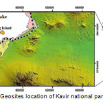 |
Figure 1: Geosites location of Kavir national park area13 Click here to View figure |
Kavir National Park Geomorphological and Tourism Features
Major geomorphosites of Kavir national park are located in dry areas, and because of their shape diversity, they had different formation conditions. This geomorphosites include puffy and plowed surfaces , salt polygons, wandering islands, barchan dunes, nebkhas, desert pavements, salt rivers, and salt bloom, which are explained below.
Barchan Dunes
are crescent-shaped sand piles that are a result of wind erosion and accumulation of fine-grained material such as sand. These shapes have a gentle slope facing the wind and two arms along the wind direction indicating wind speed at margins.14 These shapes may be symmetric or asymmetric and sometimes two barchan dunes join and form a w shaped barchan. Single and complex forms of barchan dunes can be seen around Maranjab caravanserai. The height of barchan dunes in Kavir national park (Maranjab area) reaches 5.8 meters and the maximum distance between the two arms reaches 70 meters (Fig. 2).
Saif Dunes
sword shapes dunes with sharp and distinct ridge are called saif, and they can be seen in sand areas of Kavir national park region (Fig. 3).
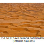 |
Figure 2: A set of Kavir national park barchan dunes (Internet sources) Click here to View figure |
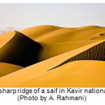 |
Figure 3: sharp ridge of a saif in Kavir national park (Photo by A. Rahmani) Click here to View figure |
Ripple marks
beautiful waveform shapes on sand surface created by the movement of water or wind are called ripple marks. In Kavir national park region, beautiful ripple marks are created by the wind, which are very spectacular (Fig. 4).
Desert pavements
These natural phenomena are mainly formed by coarse grain pieces of stone on the slopes of Siah Kuh (black mountain), and according to hardness levels they can have shiny, glossy, opaque and other surfaces.
Sand dunes
one of the beautiful and eye catching phenomena in this region is sand hills and sand dunes made by massive accumulation of sand formations. Sand particles of these hills are mostly made of quartz, feldspar and some heavy minerals15 (Fig. 5).
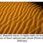 |
Figure 4: Beautiful waves of ripple marks on the sand dunes of Kavir national park desert (Photo by A. Rahmani) Click here to View figure |
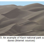 |
Figure 5: An example of Kavir national park sand dunes (Internet sources) Click here to View figure |
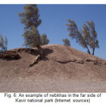
Nebkhas
These shapes are formed in the far side of Kavir national park (Maranjab desert), where high water table lets plants to grow, and because of sand particles abundance and their movement by the wind, they become trapped under the plants, and make plant pots (fig. 6). A nebkha has a life cycle of beginning the process of formation, birth, maturity, and evolution. In Iran, the highest nebkhas are belonging to the Lut Desert, ranking the first in the world, sometimes the length of nebkhas in Lut Desert reach 10 meters and their circumference reach up to 40 meters, while the highest nebkhas in Africa are 3 meters long.2
 |
|
Salt Lake
The reason for naming the lake as the Salt Lake, which is located 35 kilometers northeast of the city of Aran-o Bidgol, is due to the high concentration of salt in the water, which is estimated about 100 to 200 grams per liter of water and is about 5 times higher than sea water. Other names of this lake are Salt Lake of Qom, Aran Lake, and Mesila Lake. The lake is shaped like a triangle, headed to the north with the maximum length of 80 km, width of 30 kilometers, and located at an altitude of 800 meters from sea level. This area borders Mesila Desert to the northwest, Sefid Ab, Siah Kuh and Desert National Park to the west, and Band Rig to the south. Of important riveres pouring into this lake we can name of Karaj River, Shour River, Jajrood River, Hablehroud and Gharesou rivers. Salt Lake is dry for most of the year, and in rainy seasons, water depth reaches a few centimeters. The depth of the salt varies between 5 to 54 meters separating by layers of clay16 (Fig. 7 A & B).
 |
Figure 7: (A) Salt Lake in the dry and low rainfall seasons. (B) Salt Lake in rainy seasons (Photo by M. Foudazi) Click here to View figure |
Salt Polygons
One of the beautiful geomorphological features of Kavir national park is salt polygons frequently observed on the surface of the Salt Lake. These beautiful polygonal shapes are made of numerous tiny holes, blades and salt flakes. The underneath mud and salt layer find the way to the surface along the seams under the influence of high pressure and temperatures and cause these polygons.15 These features with curved edge are also called saltpans.17 In many desert areas of Iran that are rich in salt, such beautiful and eye-catching scenery can be seen (fig. 8).
Wandering Island
The Island is located 10 km from Maranjab Caravanserai in the southern part of Salt Lake. Its tallest point is at a height of 808 meters from sea level. The island has a red soil, covered with porous rocks and lava and there is no any plant or tree on the island. Under the effect of high temperature and refractive effects causing visual perception, the two far end of the landscape becomes blurred and obscured. These views have caused some old people in this area believe that the island is moving. That's why it is named Wandering Island (Fig. 9).
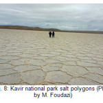 |
Figure 8: Kavir national park salt polygons (Photo by M. Foudazi) Click here to View figure |
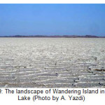 |
Figure 9: The landscape of Wandering Island in Salt Lake (Photo by A. Yazdi) Click here to View figure |
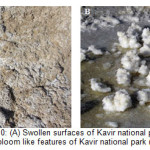
Swollen and puffy salt surfaces
These surfaces are created in clay and salt environments due to changes in the water table. That places with high ground water levels, salt water moves upward due to capillary force and when it reaches the surface, the water evaporates and the salt crystallizes, and in this case, swollen and blossom like salt surfaces are created.15 Depending on the type of these salts, they have different hardiness (Fig. 10 A & B).
 |
|
Wet regions
Wet regions in desert areas are mainly formed at location where groundwater levels are close to the surface. In this case, earth surface is soft and sticky. Since this region is near Salt Lake, it is clearly visible.
Siah Kouh (Black mountain)
The Black Mountain is located in the west of Dasht-e Kavir, in the northeast of Salt Lake and the city of Kashan and Aran-o Bidgol. Its highest point is 1865 meters above the sea level, and 211 meters above the surrounding ground level. These heights join Davazdah Emam (Twelve Imams) heights, which are in fact the main water dividing line between the Mesila and Dasht-e Kavir. The lands around Siah Kouh are marshy and access to the summit is possible only from the marked paths, accompanied by local people that know the region. Siah kouh consists of a mass of magma surrounded by tertiary sedimentary layers, and in terms of structure, it is like an onion that is split from the middle18 (Fig. 11).
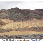 |
Figure 11: Heights surrounding of Siah Kouh18 Click here to View figure |
Geomorphology of Kavir national park
In general, the region under study is morphologically considered a floodplain. The stratified soil profile also confirms this idea. The area of the region is around thirty-two thousand hectares, and most of desert phenomena can be seen in this region13 (Table 1).
Table 1: The area of geomorphological phenomena in Kavir national park region
|
Phenomenon |
Area (ha) |
% of total area |
|
New alluviums |
6163.34 |
19.3% |
|
Sand blankets covered with sand |
2934.68 |
9.2% |
|
Fluidal plains |
2520.78 |
9.2% |
|
Desert - wet surfaces |
2466.68 |
7.7% |
|
Alluvial fans |
2427.88 |
7.6% |
|
Rocky Hills |
1809.98 |
5.6% |
|
Igneous extrusive and dacite |
1786.87 |
5.6% |
|
Parallel dunes |
1783.08 |
5.6% |
|
W shaped Barchan dunes |
1399.09 |
4.4% |
|
Desert surfaces under the effects of ground waters |
1331.93 |
4.2% |
|
Agglomerate, volcanic rocks, andesite, lime |
877.02 |
2.7% |
|
Barchan dunes |
874.26 |
2.7% |
|
Old Alluvia |
846.36 |
2.6% |
|
Foothill |
802.5 |
2.5% |
|
Nebkha |
687.51 |
2.1% |
|
Desert Seasonal wet surfaces |
674.52 |
2.1% |
|
Lime, dolomite ,shale and plutonic rocks |
593.59 |
1.8% |
|
Sandstone, lime, marl, shale and fine grained conglomerate |
524.85 |
1.6% |
|
Transverse dunes |
352.25 |
1.1% |
|
Old alluvial cone |
35.49 |
0.1% |
|
Approximate Total |
32000 |
100% |
|
Highlighted fields have the most important geotourism significance.13 |
||
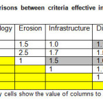
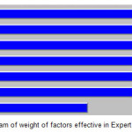
According to the purpose of the research method in this study, after determining the main criteria in development of geotourism in the area, pair comparisons were made among them based on the degree of importance, and then, weight of each criterion was determined. Table (2) and Figure (12) of the resources obtained the highest effectiveness coefficient. In fact, geomorphological features are one of most important reasons of geotourism study in the region. In Table (2), the degree of importance of rows to columns was measured, except for gray cells where the degree of importance of column to row is measured. The results of Table (2) are provided in Figure (12), where the sum total of coefficients of compared criteria is equal to 1 unit, among them, the coefficient of geomorphological features is more than 2.0, and proximity to services and settlements, water resources, and land use have equal degree of importance.
 |
|
 |
|
Study and explanation of each effective factor in ecotourism development of the region is done with emphasis on first level criteria in hierarchical analysis process model. Therefore, it is necessary to pay attention to the resources and factors effective on ecotourism development.
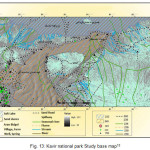
Surely, each of the first level criteria has some sub-criteria of which the layers overlap model would not be possible without weighting them. This information was prioritized and weighted by expertise questioning, and the obtained weights were used for pair comparison in Expert Choice software. Figure (13) shows the basic study map of the region along with the scores of each factor.
In modeling procedure, first, all basic maps and information layers for locating the best tourist sites were prepared, including infrastructures, residential and hydrological areas, and water resources in the region.
 |
|
Enjoying the pleasure of walking in the starry and relaxing nights of the desert
• Endurance cycling and motorcycling in the flat and large parts of the desert.
• Entertainments such as camel rides and camel races
• Arranging rally and desert rally exciting races
• Paracel and umbrella flights over the running sands
• Taking advantage of Kavir national park sky for its clean air and silence, to observe celestial bodies and stars
Conclusion
According to the researches of this study, deserts and plains of Iran, like Kavir national park, which is one of the most distinguished desert regions of the country because of its huge geomorphologic and geologic diversity, can play an important role in development of geotourism industry, if factors of development are provided.
Today, most tourists are looking for visiting natural attractions, especially unique geological phenomena, and Kavir national park is no exception due to the geographical location and proximity to the city of Kashan, which is the most important tourism centers of Iran, as well as proximity to Tehran-Isfahan highway, which is one of the most important access roads of the country. That is why Kavir national park has been the center of attention for many tourists and geoscientists. Geomorphosites of interest for tourism in the area include saif forms, barchan dunes, ripple marks, desert pavements, sand dunes, nebkhas, Salt Lake, salt polygons, inflated and puffy salt surfaces, Wandering Island, etc. This study seeks to introduce phenomena that may seem simple at first sight in a geotourism perspective, and emphasizes that by proper planning and correct management, we can take steps toward local and national geotourism development. Among the strategies that were introduced for geotourism development are development of access roads, construction of geotourism development centers, advertising, explanation of Kavir national park attractions and introducing it to the world, sending tour leader with tourists, promoting regional security, development of residential centers and so on.
In addition, besides visiting Kavir national park attractions, we suggest other fun and exciting activities such as sandboarding, rally and desert rally, endurance cycling, basking in the sun, stargazing, camel riding, and so on.
Suggestions
For geotourism development in the Kavir national park and empowerment of the management in this area, we offer the following suggestions:
- Providing Kavir national park comprehensive geotourism development plan
- Arranging specialized geotourism tours for those interested in earth sciences and tourists in tourism agencies through education of managers and staff of these centers
- Sending tour leaders to accompany geotourists
- Using information signs to guide tourists
- Creating a geotourism database for Kavir national park geotourists
- Making documentaries and educational movies in order to better introduce attractions, and promoting the culture of protecting these phenomena
- Further development of the communication network between Kavir national park and national and regional centers in order to further promote international tourism
- Providing a suitable framework for investment of private sector in this area, in line with policy of UNESCO
- Supporting residents neighboring geomorphosites to produce and provide local products, and building recreation and shopping centers
- Creating desert geotourism exhibitions and introducing capabilities of this region in different parts of the country
- Programming to attract foreign tourists through online advertising in different languages
- Holding professional conferences to introduce geotourism to the public, and getting attention of authorities for development of the region
- Developing accommodation centers for tourists
References
- Amrikazemi, A., Mehrpooya, A., Geotourism Resources of Iran, In. Dowling, R. K., Newsome, D., Geotourism, Oxford, Burlington (Elsevier Butterworth- Heinemann), pp. 173-199 (2006).
- Yazdi, A., Emami, M.H., Shafiee, S.M., Dasht-e Lut in Iran, the Most Complete Collection of Beautiful Geomorphological Phenomena of Desert, Open Journal of Geology, 4, 249-261 (2014).
- Ielenicz, M., Geotope, Geosite, Geomorphosites, The Annals of Valahia University of Trgovi et, Geographical Series, Tome 9 (2009).
- HajAlilou, B., Nekoyee Sadri, B., Geotourism, Tehran : University of Payam Noor (2011).
- Pereira, P. Pereira, D. Caetano, M. Braga, A., Geomorphosite assessment in Montesinho Natural Park (Portugal), Geographica Helvetica Jg. 62 2007/Heft 3 (2007).
- Coratza, P., Giusti, C,. A method for the evaluation of impacts on scientific quality of Geomorpholigy, I1, Quaternario, 18 (1), Volume special, pp, 306-312 (2005).
- Reynard, E., Fontana, G., Kozlik, L., Scapozza, C., A method for assessing «scientific» and «additional values» of geomorphosites, Geographica Helvetica Jg. 62 2007/Heft 3 (2007).
- Kinsley, D., Deserts of Iran and their Geomorphologic and paleoclimatologic Specifications, Translated by Abbas Pashaee, Tehran, Armed Forces Geographical Organization (2002).
- Ahmadi, H., Practical Geomorphology, Second edition, Wind Erosion, Tehran, University of Tehran (1998).
- Kardavani, P., Grand Central Desert of Iran and neighboring regions. University of Tehran, Tehran, 5-14 (2008).
- Solouti, S. and Babaniavardi, M., Desert Tour in Iran. Iran Shenasi Publication, Tehran, 17-29 (2011).
- Kheirkhah Arani, R., Geotourism potentials of Maranjab region, Sepehr, Volume XIX, No 73 (2010).
- Maghsoudi, M., Shamsi Poor, A., Noorbakhsh, F., Examining the Potential of Optimized Regions for development of Geomorphotourism (case study: Maranjab Area at South of The Salt Lake), Natural geography researches, No 77 , pp. 1-19 (2010).
- Mahmoudi, F., Dynamic Geomorphology, Tehran, University of Payam Noor, Eighth edition (2007).
- Khosravi, A., A research on natural geography features of Iran, Tehran, Armed Forces Geographical Organization (1999).
- Loghman, H ., Origin of running sands in Mesilla basin. Arid and Desert Areas Station, Kashan City (1997).
- Alaei Taleghani, M., Geomorphology of Iran. Ghomes (2007).
- IranDeserts.com


