Thinking Relatively on Nature Concept With Creating "Modern Tourism Space" At Mazandaran Through Tourism Approach
Mohaddese Yazarlou1 *
1
Department of Architecture,
Ayatollah Amoli Branch, Islamic Azad University,
Amol,
Iran
http://dx.doi.org/10.12944/CWE.10.Special-Issue1.116
Tourism industry, as the most diverse industry across the world, has some subsets. One of the Iran architectural manifestations is caravanserai which has been built on various historical eras. The most improved periods of construction and renovation of caravanserai was belonged to safavid time. Iran at safavid era was regarded as an important linking loop to international traffic. Many passengers came to Iran from various sites. Some were political agents and some other was traders who had travelled to Iran for various reasons, from other countries. Thus building caravanserai, that were considered as a hotel to international and national guests, was regarded so essential at safavid era. For this reason, Safavid Sultans (kings) had regarded it as a necessary point and started to construct caravanserai. In this era, particularly at first shah-Abbas time. Construct of caravanserai had been conducted along with ways and roads constructions and their repairs. Such human-made buildings, have been constructed across global world at various era, sometimes they was established in a region based on its special style and sometimes based on predominant government style. Nowadays, tourism development is known as a nations aims to enter foreign exchange. Regard to present economic problems such as unemployment, poor efficiency at agriculture section and over excess exploitation from natural resources, pay attention to other alternatives such as tourism, apparently is necessary. Cultural tourism and ecotourism is a new approach in economic development that in addition to economic improvement and growth can provide the probability of environment presentation and support the native culture and enrich social customs of that region. Factors of developing tourism, absorb it and region economic growth include identify and introduce ancient works over nature bed, and also taking advantage from caravanserai architecture in order to new space for supply local souvenirs, artificial crafts and temporary or short-term settlement. In this paper, it is tried to study on one ancient works through identify it within nature center (heart) as a modern tourism destination at Mazandaran, which is effective on absorbing tourism.
Copy the following to cite this article:
Yazarlou M. Thinking Relatively on Nature Concept With Creating "Modern Tourism Space" At Mazandaran Through Tourism Approach. Special Issue of Curr World Environ 2015;10(Special Issue May 2015). DOI:http://dx.doi.org/10.12944/CWE.10.Special-Issue1.116
Copy the following to cite this URL:
Yazarlou M. Thinking Relatively on Nature Concept With Creating "Modern Tourism Space" At Mazandaran Through Tourism Approach. Special Issue of Curr World Environ 2015;10(Special Issue May 2015). Available from: http://www.cwejournal.org/?p=11128
Download article (pdf)
Citation Manager
Publish History
Introduction
Vana village places on 65-km Amol town and 85-km Tehran. It is located along with Haraz River across the Haraz road. ItÙs work include Figure of "shah vana" in border of Haraz River. Also, there is an ancient shrine (offspring of Imam) at Vana that is registered nationality. It has natural landscape and suitable tourism, regions which can become to a good tourism place. In present paper, we tried to introduce one of the lithography of "Ghagar era", which has been the origin of arts in Iran, especially in mazandaran", and present the freshness within nature heart through creating a tourism pole in this region.
Identify MazandaranÙ S Location
Geographical Location of Mazandaran Province
Mazandaran province with approximately 24000 areas is located between 47′ and 38° and 5′ north width and 50° and 34′ to 56° and 14′ east height of Grinvich meridian. (Zende Del 2001).
Considering width, Mazandaran ranks in eleventh order among other provinces. It is bounded to Caspian Sea from north, to Tehran and Semnan provinces from south, to Gilan province from west and to Golestan province from east. (MazandaranÙs geography teachers 2011).
Political Geography of Mazandaran
According to last national divisions, this province with Sari centralization (sari is its capital) includes 19 towns named by Amol, Babol, Behshahr, Tonekabon, Chalos, Ramsar, Savadkooh, Abas Abad, Fereydoonkenar, Ghaemshahr, Mahmood Abad, Neka, Noor, Noshahr, Jooibar, Galoogah and Mianderood and has 52 cities, 44 districts, 113 village and 3697 roral state and 43% of cities are located along with coastal line.
Mazandaran is the only province which is connectd to countryÙ s capital (Tehran) through three pivots Haraz, Kandavan and Savadkooh and has linked to other sites of country through four airports Dashte-Naz in Sari, Noshahr, Bishekola in Babolsar and Ramsar; and also North railway crosses it, that is one of the Trans railway basic branches. In addition, coastal road cross from Ramsar to Babolsar with 220km length and distance of 10 to 30 m from the sea.
Mazandaran Natural Geography
Tabarestan has taken advantage from blessed abundant raining during various seasons, due to having high mountains and special longitude and latitude and also being adjacent to sea.
For this reason, this land is totally different with other Iran regions geographically. As, the most number of raining days related to coastal regions of Caspian Sea in Iran (Sharifian 1989). This region, due to having temperature weather, abundant water and productive land, has changed this land to a green zone, since a long time ago.
Water Resource and Watershed Domains
There is multiple barriers in Mazandaran in term of geographical location, weather, unevenness and vegetation cover. Also, regard to weather, vegetation cover and unevenness, there is various rivers in Mazandaran flowing toward Caspian Sea and terminate to it. Mazandaran rivers are multiple and all are originated from Alborz mountains and enter in Caspian Sea, and at coastal plains, some part of their water are consumed for agriculture. (Iran geographical group professionals 1987).
Most of Mazandaran Rivers are permanent, but at least, they are turned to seasonal rivers at a part of their route. Mazandaran Rivers, from winter to early spring, generally being dry and less-water due to raining shortage, decrease snow storage and increase evaporation. (kakroodi 1996).
Wholly, Mazandaran water resources are divided into 5 parts:
- Storage and deviational dams;
- Deep wells;
- Subterranean canal (aqueduct);
- Springs;
- Mineral water spring (Mazandaran geography teachers 1994).
Important rivers of Mazandaran include Neka, Tajan, Telar, Babolrood, Haraz, Dohezar, Sehezar and Safarood.
Mazandaran Topography
Mazandaran unevenness is such that it clearly can be divided into two parts of flat and mountainous. Coastal line and marginal flats are surrounded by a high barrier with long distance along with Alborz mountain chains. For this reason, land slope decrease from Albora highlands (heights) toward flat and Caspian Sea, from north to south toward southern coasts and from east to west toward sea eastern coasts. (Mazandaran geography teachers 1994).
Mazandaran Weather Properties
Mazandaran weather is divided into three parts of Caspian temperature, mountainous humid (temperature & cold) and semi-driy (semi-desert) regard to temperature and raining properties. (Mazandaran geography teachers 1994).
Raining level and humidity of air is more at west other than the east of Mazandaran. Considering raining, the most raining season is fall (autumn) and the least of it is spring. (Alijani 1994).
Mazandaran Human Geography
Race
Native people of Mazandaran had lived as Nomadism and cattle raising manner before entering Aryans tribes. The most famous of native tribes were Amard groups, and their distributions limits, based on Tabarestan history book before Islam is following as: These tribes had lived from east to Gorgan border and Khorasan, from west to Lankaran and present Caucasia, from north to Caspian Sea and from south to ancient Rey. They were divided into three distinct groups: Kadoosies, Amards and Tapoories (Sotoodeh 1996).
Kadoosies group themselves (Gelay, kadoozi and katoozi) were divided into two great and small classes: great Gelays who had lived from Lahijan to Lankaran and Talesh mountains and small Gelays at Gilan.
Amards tribes had existed from Lahijan to Gorgan border. Royan land previously was one of the residence locations of these tribes, and ancient Amol was their capital or governance center. Tapoori tribes or Tpris, who were fighter tribes, had resided in Semnan mountainous chains and ancient name of Mazandaran (Tabarestan) is referred to this tribe. In Islamic era, a large group of Hasani, Hosseini and Marashi Sayyeds had lived in Mazandaran; and other tribes, in addition to native residence and local tribes, had been migrated to Mazandaran through kings at various times, such as khaje Vands, Abdolmaleki tribes, Lak groups, Geraylys, Esanlooes, Balooches, Afghans and Kords.
Abdolmalekies had been migrated from Gaz valley to Shiraz and then to Shahryar, Karaj and Noor. Mirza Agha Khan Noori was migrated them to Dagh Marz in Behshahr at 1272. Khaja Vands originally came from "Ghak" in Lorestan. They had brought from Galiosh to Andorood, Minrood and Gharatghan at Agha Mohammad Khan time. Esanloo Torks, also had been brought to Sari and its surrounds according to Agha Mohammad Khan dictate.
A small number of Talesh people had resided in Kolt-Ghoratghan surround of Behshahr and Tonekabon and a small number of Hesarloo tribes resided in Tonekabon. Some of Ghajar tribes existed in Mazandaran. Afghans people from Ghajai tribes have existed in Ghereh Tappeh in Behshar.
Kords tribes of of "Jahan bigloo and Medanloo" were in Mazandaran and tork tribes of "Emranloo" were in Galoogah. A small number of Arabs had been broughts to Mazandaran at Agha Mohammad Khan time.
There were a small numbers of Goodar, Bengashi, Barbari, Kerachi and Kooli families in Mazandaran. Yet there is a small number of Gorjies, Armenian, and Kalimi (Jewish) in various parts of Mazandaran, who were brought to this province by Shah Abbas order.
Language
Geographical resources and local histories indicate the preralence of Tabriz language across Tabarestan and Royan. Tabrsi poems in local histories demonstrate that the common language have been same tabari language.
At Royan history, it is narrated that: there was a Tabari poet in Royan who was known as Royanian pole, he compsed a stophe-poem into tabari language; and where he remembered the Bahar speech and description of Royans hunting- grounds promised between he and general governor (Amoli 1969).
Population
According to public census in 2012, the population of Mazandaran is 3073943.
Introducing Amol Town
Amol town is confined from north to Mahmood Abad town, from north-east to Babolsar town, from east to Babol, from west to Noor and from south to Tehran. Ebn Esfandiar quoted in Tabarestan history that Amol city was occupied by muslims at 137 Hejri (according to lunar calendar). Ferizer, (1238 Hejri), has called the beauty of Amol city and its magnificent bridge named by "Davazdah Pole". According to historical doucuments, this city had been the capital of Mazandaran from Sasanian era to Moghol time, and various coins had discovered with coinage by Amol in Sasanian period.
There is abundant subjects concern to appearance of Amol, in various resources and books, that can't be included in this detailed paper.
Totally, just three theories are extracted of total subjects about Amol appearance:
Before Aryans tribe's migration to Iran plateau and residing there, a tribe had resided in northern region of Alborz mountain chains and southern margin of Caspian Sea who was known as Amards.
Poor Davood wrote that "the name of Amol city is a memorial of this same tribe who have entitled their name on this land".
Great Ardeshir believes that "people fought with fifth ask (the first far had) in Ashkanid era, and they were defeated after three years battle and a large number of them were killed. He had migrated them toward Khorasan, and they built a city as a memorial of Amol and called it "Amol", also Ebn Kherdabeh in Almasak, Moghaddasi in Ahson-Ol-Taghasim and Ebn Alebri at Mokhtasaroldoral have supported the existence of a city named by "Amol" at west part of Oxus.
The second theory related to appearance of Amol regard to Ebn Esphandiar writings, an Amolian writer, in "Tabarestan history" book. He stipulates at page 82 of above book that he had writing this book at 613 Hejri (luner). The base of this book, according to Ebn Esphandiar writing, is derived from "Aghde-sahar and Ghaladeh" book compiled by Abolhassan Ebn Mohammad Ol Yazdadi.
Ebn Esphandiar was born in Amol and had lived there. He wrote in his books that he also went to Kharazm. His narrative concern to Amol appearance is mythical. He believes that "Amol name" is taken from "Amoleh, girl of Eshtad, who with his brother, "Yazdan", came to Amol surround because of killing a person from Dylam tribes, and established Yazdan Abad (that is famous) and Ostad Rastagh village (that was a fourship village at Ebn-Esphandiar time). He wrote in Tabarestan history: Amol foundation was built by Amoleh order, the girl of one deilami village and Firooz shah Balkh wife.
The third theory about Amol appearance, that was not based on proved and logical doucuments, refer Amol to Tahmoores, Jamshid, Kioomars and ….
Molkognoph, a person tourist (1200 Hejri) believes that: there is a discrepancy about building Amols by Zahak (and kioomars, jamshid and hushing) and it is said that its building is referred to Fereydoon and Tahmoores. Dolatshah Samarghandi said in "Tazkera-tol shoara" that "Amol city is an ancient city and according to narratives it was built by Jamshid and some said that it was built by Efidoon.
Larijan
Larijan is a district of Amol town. This district is the southest region of Mazandaran province and is located on northern slope of Alborz mountain chain. Damavand Mountain located on Larijan and it can be climbed through ways in Larijan. Larijan is one of the ancient and historical regions of Iran that has included a lot of natural historical, attractions in itself. This region includes a large number of mountains villages, plains and plateaus. At present, the best and the most qualitative trout in Middle East has been bred in this region, due to existence Haraz river originated from Damavand peak. This region is one fabulous region of Iran.
Larigan district include two town named by Rineh and Gaznak and 73 villages and consisted two rural district "upper Larihan" and "lower Laeijan".
Rural district of "upper Larijan" includes Vana, Baijan, Abe garm, Garna, Nava, Gilas, Niak, Ask, Ira and Amiri (polour).
Rural district of "lower Larijan" (sofla) includes: Panjab, Delarestagh and Namarestagh and 17 villages that are known as "17 block", and is divided into parts of northern and southern section. Northern section consist of Soa, Amre Otagh Sara, Sheikh Mahalleh, Polrieh, Kolri, Kefa, Namar and Deyvaran that is a beautiful landscape of Deryook, and southern port of Namarestagh includes Nasl-Darreh kenar-Neyzeh (Aliabad), Hassan Abad, Emam zade Abdolmanaf, Kord chalek, and beautiful landscape of fis (its height to sea level is 2350 m).
Damavand Mountain, the highest Iran summit, locates on Larijan. Lar plain, Lar Lake, Lar River, Divasiab River and Gole zard cave are amongst other regions or Larijan that are located on Damavand Mountains slope.
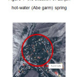 |
Figure 1: The situation of Larijan hot-water (Abe garm) spring Click here to View figure |
 |
|
Denomination
The words Laar and Lar seen in first of some names of Iran plateaus locations, and ofthen means stream and creek, so that there is 'Laar" word in Lar River and Lar Lake in Larijan. Totally, Larijan means LariGan that is a place attributes to creek. The word root is same Zar, means that as a rule "Z" turned to "L" from Pahlavi to Persian language. Dehkoda examples that 'paradise and its milk stream is same Lar water".
Population
According to Iran statistical center census, the population of Larijan district in Amol city had been 8721 at 2007. Water resources
Approximately, there are abundant springs and rivers in all sites of Larijan. At mountainous regions, it is full of water in winter and early of spring and is low-water and sometimes dries. Other water resources of region are small local Lakes that create when rivers overflow at parts that level of underground water is high, and they are used to agriculture, hunting and fishing.
A river is flowing from south to north named by "Haraz" that has terminated to Mazandaran Sea. It is other kind of water storage in which fish is bred and is one of the Mazandaran tourism attractions. There is an abundant mineral water spring which has curative benefits and is effective for cure dermatosis, arthrosis, neuralgia and digestive problems. Abe Ask, Abe garm-Larigan-Strabakoo wells and mineral water bath (sulphuric water) are among them. Hot-water springs are distributed across Iran, particularly at slope of Alborz and Zagros mountains; so most of rural district have been famed due to having such kinds of springs and are named to "Hot water" or Abe garm. Some waters, due to having a part of chemical materials, have special color, smell and flavor. Some sulphuric or sulphatic compositions give a blue or milky color to water, and a water with sulphurized Hydrogen have corrupt egg smell Hot waters with ferrous (Iran) compositions are red or orchre colors and have acrid flavor. Other salts including sodium chloride and iodosodium give a salty or bitter flavor to water.
Analyze Selected Site
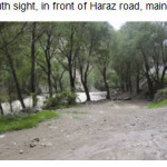
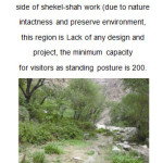
Properties of a resident region may be dictate omission of special usage or in reverse; it may be terminate to creating other special usage. On the other hand, usage are dependent on region components of each site can be identified through investigate and analyze the site; that its components have been introduced regard to our considered site and its analysis. Considered site, with relatively less distance with Amol city, should has a special properties and absorbs tourists; of course establishing welfare convenience has been explained in term of location, but it is done easily through explaining site properties. One of the considered site properties that should exactly be analyzed is locating it across Haraz road (Tehran, Amol road). In fact a beautiful view automatically is regarded as a positive factor to attract tourist.
Being country the considered region, cleanliness of water and being far from acoustic and environmental pollution are factors result in refer people and passengers there at various seasons of year, particularly spring and summer in order to rest and spend leisure time, and this condition, also is another manifestation to attract tourist in considered tourism center.
 |
|
 |
|
 |
|
 |
|
Sample of Carve (stonemasonry)
Shahi Way and Embossed Figure of Naseroddin shah
Before advent of Safavid, only a limited military expedition had been performed to mazandaran which the major of them was done by great Korosh, Mahmood Ghaznavi, Teymoor Goorkani and Asah Ismail safavi, and in all cases, army had entered to Tabarestan with so difficulty and passed it. At Great shah Abbas time, according to his dictation a stone- pavement road with high quality was established across Sari route toward Varamin (track of Ghaemshahr to Firoozkooh and remaining) route of Hablerood to Garmsar and Varamin, due to his interest on Mazandaran region and specially Behshahr and Farah Abad in Sari, that later, it had been ruined after his death because of next governors ignorance toward its repair. After reaching Ghajars to power and selecting Tehran as capital, easier accessibility to birthplace of this dynasty in Estar Abad region (present Golestan province), need to passing suitably from Alborz mountain had been imagined necessary .
During this time, in addition to Gadook bottleneck route (the route of present Firoozkooh) and Gazvin-Manjil-Rasht route, there was another way passed from Toochal Mountains, shahrestanak, Baladeh, Kojoor and Noor. At Naseroddinshah era, and by his order, old and animal-riding ways in Haraz and Chalos valleys were repaired and turned into cart-riding way. Also, Naseroddinshah again ordered to reconstruct Larijan (Haraz) way at 1290 and appointed Hossein Alikhan Vazir to supervise it. Hossein Alikhan by assistance of Gastigler, an Austria engineer, who was in the employment of Iran, so much had broadened the road that two carts in opposite side could pass without collided it.
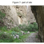 |
Figure 7: Part of site Click here to View figure |
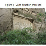
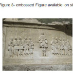
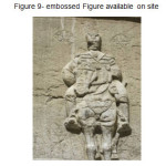
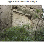
"Shekl-e-shah", in addition to beautiful nature, has numerous historical works. It is one of the three known epigraph of Ghajar era. Remaining both epigraphs is located on Alishahr spring at Rey and Washi strait at Firoozkooh. Three epigraphy have been carved by the order of FathAlishah Ghajar. He, that had spended periods before kingdom at Shiraz, as soon as seeing embossed Figures at that region, appointed three persons named by "Hajar bashi, Naghashbashi and Memarbashi to commit a responsibility to construct this epigraph in Tehran.
Date of Constructing work
In 1295, with termination of construction actions, this way was caved as a memorial of Ghajar king Figure in one of the most arduous road of this route by name "Tang band borideh" adjunct to roaring Haraz River. This embossed Figure which is known as "shakl-eshah" is considered as the newest and that historical embossed Figure or Iran, among 105 discovered embossed Figure. In this Figure, Naseroddin shah is in the middle mounted on a horse and 10 countries are caved at both sides. Around the Figure with 4m height and 8m length, poems have been caved to praise Naseroddinshah and hos order concern to repair Larigan way.
 |
|
 |
|
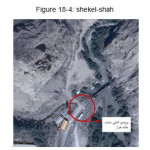
This outstanding Figure had distanced from road routes during the second Pahlavi time and by terminating the construction of Haraz Paved road in 1962s and Vanas tunnel in order to unused the dangerous region "Tang Band Borideh", and until now it alone place on west side of strait wall looking the flowing Haraz river. To visit this Figure, one should stop at one side of Vana tunnel and nearly walk across western side of river behind the tunnel for 10 minutes. This outstanding Figure is nearly located on front of second emergency output of Vana tunnel from Tehran side.
 |
|
 |
|
At present, the only guide board of this fistorical work is mounted approximately on 150m of Vana tunnel from Tehran side and at left side of road, locality of this board is such that it at all has not been attracted by tourists travelling toward Amol. On the other hand tourists of apposite side, never see writing on the board, too!!! Unfortunately, for a sometimes, it is rumored that a new road will be constructed in this strait in order to reduce Vana tunnel traffic. This case is surprising from two aspects:
First, establishing this road will lead to serious damage and destruction of historical work of shekel shah and remainder of Larijan historical road toward Amol which came back to Sasanid dynasty.
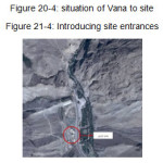 |
Figure21-4: Introducing site entrances |
Builder of Work
Around the outstanding image, there are 16 verses in laudation of Naseroddin shah and difficulty of passage (traffic) across Larijan way and shah dictation about its repair. Finally, the name of engineer Mohammad hossein Mirza, Ragheme Abolfazl (savogi) and Aliakbar (stone) cutter is mentioned.
Managing Tourism Site
Shekel shah is public and free for visiting and traveller and visitors pay no cast to parking. Providing sanitary service is unbelievably poor. It can be said that, region has been left, in the term of civil management. Pouring rubbish by visitors has been created unpleasant images alongside beautiful natural landscape.
ItÙ s tourism attractiveness will be double if nature, history and visitors demand for this region were managed as well.
Weather
In the term of weather, considered site locates on Amol and Larijan climate domain, studied on previous part. (it has moderate semi-humid and cold, mediterrannean climate).
Geology
Considering that assumed site locates on Haraz road, yhus it has characteristic like Haraz road aspects, in the term of geology that will be explained at next parts.
Haraz road is located on a range from Cambrian stone to quartzite. Regard to Varity of infrastructure stone type, geological properties, climate characteristic, height from sea level and also road distance to great faults, it is impossible to analyze centrally the instability of this road. The most important geological factors result in instability includes Mosha and Baijan landslide faults, and also Damavant Volcano. A part of road is built on alluvium sediments and Damavand unstable volcanic ashes that all the time have been treated by danger of landslide of that kind happened on 1987. Quartzite's that are products of Damavand Volcano, appear sever instability in respond to weather changes and erosion. Other parts of road, especially at "Abe Ask" region, have been the most great center of landslide in this region and for many time, long route of road was attacked by landslide (sometimes to 600 m length) , and is built again.
Vegetation
Vegetation of this site, that are part of Haraz road includes:
Matchless Hirkani jungles and country pastures.
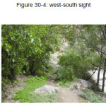
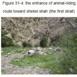
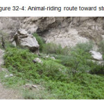
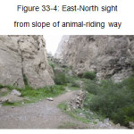
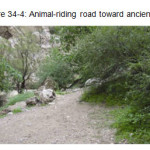
Site Entrances
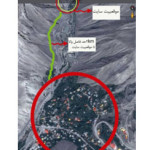
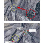
As it is seen on following Figure, considered site has a main entrance from Haraz route and a side entrance (secondary) that is animal-riding way.
 |
|
 |
|
 |
|
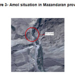
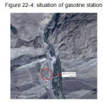
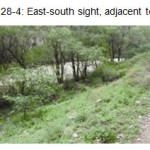
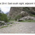
Vana village is placed on 65km Amol town and 85km Tehran. It is located on the route of Haraz road and across the Haraz River. Also, considering adjacency, places adjacent to site have not been used for a special purpose. It should be noted that the situation of gasoline station and entertainment tourism services of breeding-fish basin (Mahichal) across the site route, are shown at following image.
 |
|
 |
|
Site at a Glance
 |
|
 |
|
 |
|
 |
|
 |
|
 |
|
 |
|
 |
|
Conclusion
Creating a situation for life and asset security is a necessary condition for passengers and tourist that should be secured. After security, the first and most important necessary facilities that tourists need are Hotel and temporary residence. Place of residence and hotels, basically should provide services and food to passengers. Other actions including sport and places and conferences salon and ticket-selling agency, are examples of residence place spaces that should necessarily provide to tourists.
References
- Sharifian, Ardeshir, Vaziri Behrooz et al (2014), presenting architectecture guidelines to design recreate-residence settings in direction of encourage and promote tourism industry, the first national conferences of tourism management, nature and geography.
- Ebn Esfandiar, Bahaoddin Mohammad Ebn Hassan Ebn espandiar (1988); Tabarestan history from beginning of Tabarestan base to Ale Ziar domination, corrected by Abbas Eghbal Ashtiani, Tehran, Padide Khavar.
- Mazandaran geography teacher (1994), Mazandaran geography, Mazandaran: education Ministry programming and research office publication.
- Sotoodeh Manoochehr (1996); from Astara to Estarabad, Tehran, Aghah, 5volumes.
- Alijani B. (1991); humid resource of Iran rainings/ seventh geographical congress of Iran, Tehran university, published in 1994.
- Amoli aliollah (1969), Royan history, corrected by Manoocher sotodeh, Tehran. Iran culture foundation.


