Evaluation of Infiltration Behaviour and Soil Characteristics in Dhanbad – Jharia Township Area, Jharkhand, India
Ritu Ranjan Sinha * and Prasoon Kumar Singh
http://dx.doi.org/10.12944/CWE.11.2.29
As a consequence of interaction between human and surrounding urban soils are generally sealed, compacted and contaminated. Thus investigating and understanding the processes, properties and functions of these soil posses a great challenge for the large human population. The prime goal of this study has to evaluate and relate the steady state infiltration rate with parameters which has significant impact on it. The various parameter considered here includes bulk density, total porosity, organic matter, sand, silt and clay content. Further, current study was also analysed by thematic maps such as soil and geomorphology map. Sixteen locations were selected randomly and experiment was conducted through double ring infiltrometer having inner and outer diameter 30 and 60 cm in the interval of 5,5,10,10,15,15,30,30 minutes. Soil samples were also collected near by the each experiment site for the determination of above said parameters. The results of the infiltration rates was mapped by applying the interpolation method of the Arc GIS 10 software and classified as slow, slow to medium and medium classes. Furthermore, the generated data were subjected to correlation and regression analysis which reveals the significant positive correlation with total porosity, sand organic matter, having r = 0.818, 0.811 and 0.573 where as bulk density, silt and clay were significantly negatively correlated as r = - 0.627, -0.693 and - 0.444.Overall, the measured infiltration rate varies from slow to medium class which may be due to the soil compaction and other parameters. So to over come this hazard appropriate environmental measure must be applied and plant cover must be increased.
Copy the following to cite this article:
Sinha R. R, Singh P. K. Evaluation of Infiltration Behaviour and Soil Characteristics in Dhanbad – Jharia Township Area, Jharkhand, India. Curr World Environ 2016;11(2) DOI:http://dx.doi.org/10.12944/CWE.11.2.29
Copy the following to cite this URL:
Sinha R. R, Singh P. K. Evaluation of Infiltration Behaviour and Soil Characteristics in Dhanbad – Jharia Township Area, Jharkhand, India. Curr World Environ 2016;11(2). Available from: http://www.cwejournal.org/?p=16000
Download article (pdf) Citation Manager Publish History
Introduction
Soil is the key ingredient for the maintenance of the ecological services such as cycling of the water, plays vital role in vegetal progression and in the form of foundation material used in the construction of building which ultimately sustains and support the human population.1 Besides this, soil also act as source and sink for the contaminant that causes the potential threat to human health.2 Continuous urbanization process is the most common phenomenon throughout the world3 as a consequence of this there is increase in the urban soil. Urban soil vary significantly from original one due to increased human activity and this phenomenon accelerates compaction6 by virtue of industrial and mining activities, traffics and waste from urban residential area.4,5 The urban soil strata show special characteristics having high level of diversity with physical deterioration and mechanical compaction.
Among the wide range of global problem soil compaction is the most severe issue in the urban environment.7 The above said phenomenon may be defined as the decrease in the porosity and given mass of soil8 with higher bulk density of the soil.9 In recent decades many part of the globe are facing flood problem during monsoon seasons due to more surface sealing, less availability of bare ground surfaces leading to soil compaction.7 Compaction also brings remarkable changes in the emission of CO2, CH4 and N2O which may leads to global warming of the atmosphere.11 When the soil is compacted it adversely affect the plant root growth due to reduction in the storage of water supply and nutrient.10 Furthermore, due to compaction there is hindrance in the soil water and air movement which causes lesser soil water infiltration. Decrease rate of soil water infiltration leads to more storm water discharge during the rainfall event which allows frequent flood event and poor surface water quality.
The phenomenon is called infiltration when the water moves gravitationally downward through the soil surfaces12,,14,15,16,17,18 and the rate through which it take place is called as infiltration rate. The total penetrated water to the soil horizon has two fate as surface runoff and the ground water recharge.13 The study of infiltration behaviour offers better suited information on hydrological functioning of landscapes. The infiltration properties of the soil is also helpful in finding the different techniques for soil conservation, planning and scale of irrigation design, and assist in the identification of genuine depiction of water retention and aeration in the soil profile. The measured hydrodynamics of infiltration rate is significant trade – offs in supplement other soil information which draw attention to soil specialist, engineers, hydrologist and others to tackle the problem of water and soil resource. The purpose of the work presented here is to estimate the infiltration behaviour of the compacted urban soil with its relative influence of soil physical properties. Also, the current research enhances our knowledge for appreciating the influence caused by bulk density, total porosity, organic matter, sand, silt and clay content, slope, soil types and geomorphology on the the infiltration behaviour.
Study Area
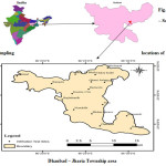
Dhanbad - Jharia Township located in the southern part of Dhanbad district in the Jharkhand State ( Fig-1) bounded by the longitudes 850 15’ E to 860 33’ E and latitudes of 230 37’ N to 230 51’ N having the area 230.94 km2. The mean annual precipitation of the region is 1,300 mm with more than 85% of the precipitation received during the June to September. The study area experiences tropical hot type climate with three distinct seasons as summer, monsoon and winter and attains the minimum temperature 50C to 80C during December to January and maximum temperature 420C to 460C during May to June. As per the census of india 2011 the township has a total population of 11,62472 consisting in 55 wards. River Damodar flows in the southern part of the town which marks as natural boundary. The geological characteristics of the area varies from Archean to recent. At base Archean formation which is overlain by Talchir formation followed by the Barakar formation and at the top comes the Barren Measures. Archean formation of the study area include metamorphic rock types of Chotanagpur granite and gneisses. Rest other formations are formed mainly of sedimentary rocks of Gondwana super group. Among all the formation Barakars formation are economically the most important due to presence of number of thick, good quality coal seam.
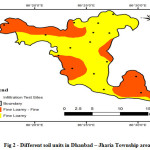
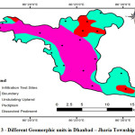
Large variation in the temperature and rainfall with alternate wet and dry periods have led to formation of lateritic type of soil in the area. Since soil rarely exist in nature separately as single component but is typically found as mixture with varying proportions of constituent grains of various dimension. Maximum portion of the study area is covered with loamy soil(Fig-2) with sparse distinction of sandy loam. The most important aspect of this semi- arid locale is its location as it is very near to Jharia – coalfield which contains coal and where continuous mining and its allied activities is going on. Therefore, the present study may serve as indicator of soil disturbances due to mining and anthropogenic activities. Further the geomorphology of the study area was classified into three different geomorphic units viz. pediplain, dissected pediment and undulating upland as depicted in Fig-3. Pediplain which are moderately undulating with featureless and plain surfaces made up of flat rocks by the association of many pediments and peneplains and covers most of the part in the township. Undulating upland is identified by moderate to high steep slope which generates high run off and made up of buried pediments with intermontane valley. Dissected pediment is characterised by isolated ridges, rock hills and knobs which rise suddenly from the near by plan or gentle slop land and have barren land.
 |
|
 |
|
 |
|
Material and Methods
Double ring infiltrometer having the inner diameter of 30 cm and outer of 60 cm has been used to determine the infiltration rate by following the procedure described by Dakshinamurthi and Gupta,(1968).19 Both the rings were driven at least 5 cm into the surface ground to avoid the horizontal leakage. Further the outer ring were wetted 5 min before filling the inner ring with water. The importance of the outer ring is to insure the water movement in the inner ring in the vertical direction only. The experiments was made to continue until the steady state was achieved (at least 90 minutes to 120 minutes) having the interval 5, 5, 10, 10, 15, 15, 30, 30 minute. Sampling was done in the month of June, 2014 at 16 selected locations. In addition to this sampling sites was randomized to avoid any biasing of results. Bulk density core and surface soil samples were also collected as close as possible to the infiltrometer ring. With the help of iron corer. Sixteen soil samples (0-15cm depth) were collected and put into plastic covers. After that all the samples were brought to the laboratory, dried out, crushed, sieved then analysed.
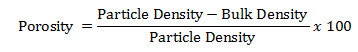
Bulk density was estimated by soil core method having length and diameter 15 x 7 cm. After first determined the organic carbon following the methodology of Walkley and Blake organic matter was calculated by using a conversion factor of 1.724.21 Texture analysis was done by using the methodology of soil hydrometer. Porosity was determined with the help of bulk density by using the relationship.
Here, particle density was analysed through Keen Box.22 The average value of analysed data is shown in Table 1.
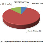
In last decade remote sensing and GIS tools has been utilized extensively for collecting and handling spatial data in several areas including engineering, geology and environmental fields. ARC GIS -10 software were used for the preparation of various thematic maps such as soil, geomorphology and soil infiltrability map. For this topographic map (1:5000 scale) was digitised and used as a base map. Further, final infiltration rate (Ks) was categorised into different classes23,7 as very slow ( When Ks is less than 1or 1 mm/hr), slow ( Ks = 1-5 mm/hr), slow to medium ( Ks = 5-20 mm/hr) & medium ( Ks = 20- 63 mm/hr). The data were statistically analysed by correlation and regression analysis for the estimation of the relationship between infiltration rates and analysed soil parameters.
Table 1: Physicochemical Properties Of Soils From Various Sites Of Dhanbad Jharia Township Area.
|
Soil Parameters |
Range (Min – Max) |
Mean ±SD |
|
Infiltration Rate (mm/hr) Bulk Density (g/cm3) Porosity (%) Organic Matter (%) Sand (%) Silt (%) Clay (%)
|
4.5 -29.7 1.2 – 1.6 30.1 – 44.5 0.74 -1.67 37.7 - 61.0 29.6 – 48.8 7.8 - 16
|
13.7 ± 6.7 1.4 ± 0.11 37.3 ± 3.8 1.15 ± 0.28 48.7 ± 6.1 40.1 ± 5.6 11.4 ± 2.55
|
Results and Discussion
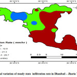
Spatio- temporal variation of steady state infiltration rate in Dhanbad – Jharia township area is presented in Fig - 4. Its value ranged from 4.5 to 29.7 (mean 13.07 ± 6.7) and falls under following classes slow ( Ks = 1-5 mm/hr), slow to medium ( Ks = 5-20 mm/hr) and medium ( Ks = 20- 63 mm/hr) as 6.25% slow, 12.5% medium, 81.25% slow to medium as shown in fig.- 5. The average value of other soil parameters are presented in table- 1.
 |
|
 |
|
Table 2: Correlation And Regression Analysis Of Final Infiltration Rates With Selected Physicochemical Prameters Of Soil
|
Soil Physicochemical Parameter |
r |
r2 |
Regression Line |
|
Bulk Density
Total Porosity
Sand
Organic Matter
Silt
Clay |
-0.627
0.818
0.811
0.573
-0.693
-0.444
|
0.393
0.670
0.660
0.328
0.480
0.197 |
Infiltration Rate = 67.248 – 36.986 Bulk Density
Infiltration Rate = - 38.31+ 1.397Total Porosity
Infiltration Rate = - 29.481 + 0.8881 Sand
Infiltration Rate = - 2.10+ 13.692 Organic Matter
Infiltration Rate = 47.051 – 0.4802 Silt
Infiltration Rate = 27.079 -1.674 Clay |
The lowest value was faund at the site Budha which lies under the dissected pediment geomorphic unit which is slopy land and generate high runoff and less infiltration. Also the soil unit of this area is disturbed and compacted due to vehicular traffic, by pedestrians and construction activity. As a result there is increase in clay content and compactness whereas reduction in pore space creating the soil layer less permeable. The highest value was found at the site Basjora which lies under the pediplane geomorphic unit characterised by flat surface which allows more water to infiltrate. Also at this site there is increase in the sand content and organic matter of the soil may be supplemented from solid waste, over burden dump and due to mining allied activity in the nearby area. Since soil texture and structure significantly affect the infiltration rate24 and both had been altered in the whole study area due to change in land use pattern, mechanical compaction and mining along with mine fire problem in the adjacent Jharia coalfield. Besides this the variation observed in the final infiltration rate were also attributed to the factors such as bulk density (1.24 -1.60 g/cm3), total porosity (30.1 - 44.5%), organic matter ( 0.74 – 1.67%), sand ( 37.7 - 61%), silt (29.6 - 48.4 % ) and clay (7.8 -16 %) content. It was also observed that there was close relationship among porosity and sand content with infiltration rate. Higher the porosity and sand content less denser the soil consequently more the infiltration rate. Similarly higher the organic content within soil profile more will be the infiltration rate and reverse is the case in clay and silt and bulk density. Further, the native soil of the area is basically fine loamy soil so the cracks may occurs in the surface layer which may enhance the final infiltration rate. The significant relationship among variables could also be explained by correlation as well as regression analysis conducted for the dependent variables against the independent variables shown in Table 2. Total porosity, sand, organic matter, were positively correlated as r = 0.818, 0.811 and 0.573. However bulk density, silt and clay were negatively correlated as r = - 0.627, -0.693 and - 0.444.
In conclusion, the infiltration rate of the study area fallen into the slow, slow to medium and medium classes. This variation was attributed to soil compaction, bulk density, organic matter, total porosity, sand, silt and clay content, alteration in soil structure, soil texture and change in land use pattern. Hence it was recommended to amend soil compaction by mechanical loosening, reducing foot and vehicular traffic, involving the treatment administration along with increase in green belt and vegetation cover.
Acknowledgment
The authors are sincerely thankful to HOD/ESE, ISM Dhanbad, India for his moral support and suggestions. One of the authors (Ritu Ranjan Sinha) is also thankful to the editor in chief and reviewers for valuable comments to improve the quality of the manuscript.
References
- Abrahams, P. W., Soils: Their Implications to Human Health. The Science of the Total Environment, 291: 1–32 (2002).
CrossRef - De Kimpe, C.R., Morel, J.L., Urban Soil Management: A Growing Concern. Soil Sci 165,(1):31 –40(2000).
CrossRef - Luo, X.S.,Yu. S., Zhu, Y.G, & Li ,X.D., Trace Metal Contamination in Urban Soils of China. Science of the Total Environment,421–422 :17–30(2012).
CrossRef - Biasioli, M., Barberis, R., & Ajmone-Marsan, F., The Influence of a large City on Some Soil Properties and Metals Content. Science of the Total Environment , 356 : 154– 164(2006).
CrossRef - Wong, C.S.C., Li, X.D., Thornton, I., Urban Environmental Geochemistry of Trace Metals. Environ Pollut,142:1-16(2006).
CrossRef - Yang, J.L., & Zhang, G. L., Formation, Characteristics and Eco-environmental Implications of Urban Soils – A Review. Soil Science and Plant Nutrition, 61:30–46(2015).
CrossRef - Yang, J.L., & Zhang, G. L., Water Infiltration in Urban Soils and Its Effects on the Quantity and Quality of Runoff. Jounal of Soils Sediments,11:751–761(2011).
CrossRef - Dexter, A.R., Soil Physical Quality Part I. Theory, Effects of Soil Texture Density, and Organic Matter, and Effects on Root Growth. Geoderma, 120 : 201–214 (2004).
CrossRef - Arvidsson, J., Influence of Soil Texture and Organic Matter Content on Bulk Density, Air Content, Compression Index and Crop Yield in Field and Laboratory Compression Experiments. Soil & Tillage Research, 49: 159 -170 (1998).
CrossRef - Celik, I., Gunal, H., Budak, M ., & Akpinar, C., Effects of Long-Term Organic and Mineral Fertilizers on Bulk Density and Penetration Resistance in Semi-Arid Mediterranean Soil Conditions. Geoderma 160 : 236–243(2010).
CrossRef - Horna, R., Domialb, H., Slowihka-Jurkiewiczb, A., Ouwerkerkc, C. V., Soil Compaction Processes and Their Effects on the Structure of Arable Soils and the Environment. Soil & Tillage Research, 35: 23-36 (1995).
CrossRef - Hillel, D., Environmental Soil physics. Academic Press San Diego CA., page no-386, 1996.
- Singh, P. K.,Sinha, R.R., & Kumar, A., A Review on Methodology Regarding the Measurement of Soil Infiltration. International Journal of ChemTech Research, 7(5): 2381-2390,(2014-2015).
- Cerda, A., Seasonal Variability of Infiltration Rates Under Contrasting Slope Conditions in Southeast Spain. Geoderma , (69): 217-232 (1996).
CrossRef - J., & Shanley T., Infiltration Rate Assessment of Some Major Soil. Irish Geography, Volume 36(1): 32-46 (2003).
CrossRef - M., Bralts V. F., Yinghua . P., Han .L., & Tingwu L., Methods for Measuring Soil Infiltration: State of the Art. Int J Agric & Biol Eng . 1(1), 22-30 ( 2008).
- Ayorinde ,A.O., Uka, U .S., & Ifeanyi, E .H.,The Effect of landuse on the Infiltration Capacity of Coastal Plain Soils of Calabar- Nigeria. International journal of applied science and Technology, 2(2) (2012).
- Dagadu, J.S., & Nimbalkar P. T., Infiltration Studies of Different Soils under Different Soil Conditions and Comparison of Infiltration Models with Field Data. IJAET 3(2) : 154- 157, EISSN 0976-3945, www.lopdf.net , Accessed 11/8/2013,(2012).
- Dakshinamurthi, C.,& Gupta, R.P., Practices in Soil Physics. IARI,New Delhi,(1968).
- Maiti, S.K., Handbook of Methods in Environmental Studies. (Vol. 2); Jaipur: India ABD Pub, PP. 141–144 (2003).
- Walkley, A. J., & Black, C. A., An Estimation of the Degtjareff Method for Determining Soil Organic Matter and a Proposed Modification of the Chromic Acid Titration Method. Soil Science, 37: 29–38, ( 1934).
CrossRef - Baruah, T. C., & Barthakur, H. P., A text book of soil analysis. New Delhi: Vikas Publishing House. Pvt. Ltd (1999).
- Kohnke, , Soil physics. McGraw-Hill, New York.(1968).
- Tiwari, A.K., Singh, P. K., Chandra, S., & Ghosh, A., Assessment of Groundwater Level Fluctuation by Using Remote Sensing and GIS in West Bokaro Coalfield, Jharkhand, India. ISH Journal of Hydraulic Engineering,( 2015).


