Optimization of Household Waste Collection Routes Using GIS: Case Study El Bousten district, commune of Sfax, Tunisia
Rim Sallem 1 * and Mohamed Jamel Rouis2
1
Unit of research environmental geotechnique and civil materials,
University of Sfax,
Tunisia
2
Department of Geology,
Sfax National School of Engineering,
P.O. Box 1173,
3038 Sfax
Tunisia
http://dx.doi.org/10.12944/CWE.12.1.07
This paper presents a method for optimizing the household waste collection system supported by Geographical Information System (GIS) tool for the sector 1of district El Bousten of Sfax commune, Tunisia. The ArcGIS Network Analyst based model is applied for the purpose of improving the collection process effectiveness, namely, the household collection bins’ reallocation along with the vehicles’ tour optimization procedure in terms of distance and time. Results indicated a reduction of 25, 83% in route and 21, 5 % in the time spent of collection along with fuel consumption savings. These findings show that GIS based model tends to exhibit significant improvements as to the collection and transportation system, therefore, to its economical and environmental costs.
Copy the following to cite this article:
Sallem R, Rouis M. J. Optimization of Household Waste Collection Routes Using GIS: Case Study El Bousten district, commune of Sfax, Tunisia. Curr World Environ 2017;12(1). DOI:http://dx.doi.org/10.12944/CWE.12.1.07
Copy the following to cite this URL:
Sallem R, Rouis M. J. Optimization of Household Waste Collection Routes Using GIS: Case Study El Bousten district, commune of Sfax, Tunisia. Curr World Environ 2017;12(1). Available from: http://www.cwejournal.org/?p=16892
Download article (pdf) Citation Manager Publish History
Introduction
Waste management is a global environment issue, which constitutes a very significant problem in today’s world. Since improper waste management places inhabitants at risk, urban waste management is presently receiving greater attention from municipalities in developed and developing countries because of its impact on public concern for the environment1,2-3.There is a considerable amount of waste disposal without proper segregation, which is leading to both economic and environmental problems. The collection and transport of household wastes are among the most important factors in the management of wastes, hence representing a major part of the budget. Consequently, it is essential for a lasting management to reduce in the first hand the impact on the environment and on the other hand to minimize the cost of collection and transport. For this purpose, one must have reliable elements for optimizing the circuits of collection, which show the most common difficulties in this type of management 4.
In this respect, the Geographic Information System (GIS) invention turns out to offer a highly innovative modeling option, allowing the decision takers to investigate or devise a wide range of the waste managing related issues. Indeed, integration of GIS technology with solid waste management has been recognized as one of the most promising approach to automate the process of planning and better management of solid waste management5-6 .Optimization of waste collection and transportation making use of the novel tools offered by spatial modeling techniques and GIS may provide large economic and environmental savings through the reduction of travel time, distance, fuel consumption and pollutants emissions7, 8,9,10,11,12.
In this regard, several works applied the GIS for general studies of vehicle traffic (Ericsson et al., 2006; Taylor et al., 2000) 13-14 or to the wastes collection, the deposit point of containers and the vehicle routing (Apaydin and Gönüllü, 2008 15; Ghose et al., 200616; JoviÄić et al., 201117; Karamidas et al., 20085; Lakshumi et al., 200618; Tarantilis et al., 200419; Tavares et al., 200912; Teixeira et al., 2014;20 Zamorano et al., 2009 21; Zsigraiova et al., 2009, 2013 22-23). The problem of vehicle routing is a common one: each vehicle must travel in the study area and visit all the waste bins, in a way that minimizes the total travel cost: most often distance or time but also fuel consumption, CO2 emissions etc. (Chalkias and Lasaridi, 2011 24).
With regard to the Tunisian context, expenditure on garbage collection and transport constitutes 75% of the total solid waste management budget, most of which is spent on payrolls salaries and fuel. Noteworthy, however, is that the present collection process has always been undertaken in an indiscriminate and irrational manner, manely with regard to the jurisdiction of the Sfax city municipality. As a matter of fact, the household waste collection vehicles are usually assigned to operate in several areas without any seriously elaborated demand analysis study, with the route itinerary being left to the truck drivers themselves. Such a state has often engendered remarkably high solid waste collection costs.
This research is conducted with the purpose of optimizing the household waste collecting routs in terms of distance and time at the comprehensive waste management. The Network Analysis toolbox of the ArcGIS software is utilized to evaluate the optimal waste collection routes.
Materials and Methods
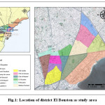
Case study area and current status of the collection system
Covering an area of 325 acres and 15707 inhabitants, the El Bousten district is selected as a case study with regard to the present work. The district El Bousten, stands as one of the most important districts of the commune of Sfax, englobing 7 districts: El Medina, Sidi Mansour, Sfax Nord, Errbadh, Merkez Chaker, Cite El Habib and El Bousten (Fig.1). It is actually a very representative area as it covers a large number of residential buildings, offices, shops and restaurants, as well as a faculty and students’ dormitory. The privately owned company of Mohamed Ben Saad is responsible for annually collecting and transporting 7000 tons of household garbage wastes and rubbish, i.e., 1.25 kg/ capita. The generated solid waste is transported by means of 2 compaction vehicles of 16 m3 capacity along with 2 tractors of 5 m3 capacity for disposal in the transfer station, 17 km away from the depot.
The collection timing program is daily executed from 9:00 am to 3 pm, and waste collection is carried out manually and mechanically. The collection transportation cost relevant to the district El Bousten is 41 TND/t.
 |
|
Empirically, and to facilitate the operation procedure, the district is divided into three sectors, with a frequent collection and transportation undertaken over seven days of the week.
The study area, subject of the present study, belongs to sector 1, and the examined area covers about 0.75 km2, with a population exceeding 8841citizens and a waste generation rate of about 10,300 tons per day, according to the collection vehicles’ weighing sheets over the year 2012. The actual waste collection process is performed at street and household residential dwelling level, using compacting truck and two hand-pushed carts. In this sector, the waste collection is entirely allotted to the vehicle driver, engendering immense losses being recorded in matters of time amount and distance traveled, therefore, increased operational costs. Several studies conducted by researchers reveal well that itineraries being left to the truck drivers’ experiences do not necessary signify that best routes are actually pursued. Currently, the private company’s applied system appears to be inaccurately improvised, unscientific, outdated and inefficient. With solid waste being littered wherever possible, the private company does not seem to have adequate provisions to effectively deal with the ever-growing problem of solid waste management. Indeed, no effort has been made to store waste at the selection source site, much less no norm is being undertaken on setting the bins’ capacity and placement, resulting in some bins/pits remaining overflow. Given such noticeable defects observed to prevail within the existing waste management, a special methodology relevant to adequate the household waste collection and transportation procedure seem imposed , as based on the GIS model devised process.
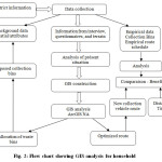
Methodology
By relying on GIS, the collection system optimization approach turns out to stand as an effective means, whereby spatial data can be imported, managed, and analyzed.
The present work’s pursued methodology consists of three major stages, namely (Figure 2):
- Data collection
- Spatial Database development
- GIS Analyses: ArcGIS NA
 |
|
Data collection
In cooperation with the Sfax municipality and nomena fieldwork, the following data have been gathered and processed in suitable forms (vectors, tables, and raster): delimitation of the study area; detailed land use plan of the municipality; population distribution and density; satellite image (Google Earth); road network; and information on roads (traffic, restrictions, and signs). The collection route has been tracked via a GPS (Global Positioning System) to extract all the relevant data and facts: coordinates of collection points, from parking (starting point/circuit end) and from landfill; the capacity and the vehicles’ number and capacity as used in the collection; the route of each vehicle, number of workers, condition of waste on site, condition of container and bins, odometer reading before departure and after collection time. Certain background spatial data were taken from the municipality of Sfax. It concerns road network, existing routes, bins and building parcels. All data are restructured with field work as well as non spatial data for instance road name, road type, vehicle average speed, travel time, road slope, bin number, bin type/capacity, bin collection time are added . The collected information is then stored in a spatial database.
Spatial Database development
The geodatabase was constructed using the GIS environment of ArcGIS (ESRI).The main sources of the spatial database (SDB) are urban development plan, maps digitized in ArcGis10.1, satellite images (Google Earth), municipal and statistical services data, data derived from field work and literature data and the company responsible for the waste collection service. These data are geodetically corrected into the Lambert Conic Conform Projection System. Once the database is established, an optimization model is performed through application of the Network Analyst (NA) tool on ArcGIS.
GIS Analyses: ArcGIS NA
The Network Analyst extension of ESRI ArcGIS was used in this study to recommend optimization of the route. It is a powerful extension that helps providing network-based spatial processing involving routing, travel directions, closest facility, and service area analyses. The Network Analyst extension allows users to represent real network conditions and resolve vehicle routing problems that incorporate turn limitations, speed limits, elevation restrictions, and travel conditions.
With the ability to help in finding the shortest route through all containers for waste collection, while simply showing their locations. After setting the stop points, the optimized routes for the solid waste collection were produced. The sequence of stoppages to be visited was defined via Network Analyst. It includes a cost reduction option (the impedance) to be derived during the calculation of the best route. So, the most optimum path can be determined as that with the shortest circuit and therefore, costs the least, with the itinerary being selected by the user himself. As far as the present work is conceived, using Network Analyst to define an optimum path fit for the waste collection process is generated with respect to the area subject of study.
Results and Discussion
The above mentioned approach has been used in our context for the purpose of examining the household garbage collection method with the jurisdiction of the Sfax municipality.
Actually, two different undertakings or procedures are being considered at this level namely the waste bins reallocation as well as an optimal route analysis using the nearly proposed bins sites.
Reallocation of the household collection bins
According to the statuesque situation, a total of 28 collection bins are placed in sector 1 of the district El Bousten, with holding capacities of 360l, with no norm has been followed to allocate these bins. For the sake of further to improving the existent collection system in the ward, the insufficiency related to the waste collecting containers and their service areas is reconsidered. Adding an additional tray is required for each tray overflowing.
We proceed to the reallocation of these bins in the study sector according to the following criteria:
- Allocating bins wherever open dumps are persistent
- Installing new bins next to existing bins’ locations
- Allowing the installation of several bins per every single crossing.
In a stage, the essential number of waste bins to be placed was assessed according to the daily and weekly waste quantities generated in the sector 1 along with the suggestion to substitute the small bins with larger ones of 770 l capacity. This procedure is given by equation (1) as follows:
Where,
N = Number of bins
W = Total quantity of waste generated per day in Kg
D = Average density of household waste in Kg m−3
S = Bin capacity in m3
F1 = Coefficient of filling the bin (considered 80% in the present study)
CF = Collection Frequency
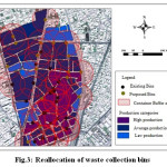
Hence, a need for 18 extra appears to persist as a solution bins to absorb the excessively overflowing bins, in considering an average waste density of 0.4 t/m3 and 0.77m3 capacity containers. It has been noted that most of the circuit containers have a volume of 0, 36 m3 while the minor part is formed by containers of a smaller volume of 0, 75 m3.This number is assumed to adequately suffice by suggesting to locate containers in sites which might serve the entire population. Bins’ redistribution is performed according to the distance separating them from dwellings, with the aim of increasing the bins’ number. Thus, the longest distance to be traveled would not exceed 125 meters from the residential areas. The total area of sector 1 is covered by 46 bins of 0.75m3. Figure 3 highlights the redistribution of the waste bins throughout the sector.
 |
|
Optimal Routing
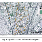
Following the waste bins’ redistribution, we proceed to optimizing the collection vehicle’s routing. Figure 4 shows the proposed bins as collecting points and the possible shortest route.
 |
|
Route optimized by using the software was compared with present route.
The comparison results are presented in Table 1. According to the Table1, the optimal route corresponds to 8.9 km that the collection vehicle could traveled, as compared to 12 km currently traveled. This is 25.83% amelioration in respect of the current routing. Such a progress appears to be pronounced with the respect to the optimal routing travel time amount. Routing total travel time is calculated as time spent by the collection vehicle added to the bins’ collection time. Global timing with respect to the optimal itinerary is 211 minutes as a substitute of 269 minutes relevant the previously undertaken existing route (i.e. 21.5 % gains in the total collection time).
Given the fact that gasoline consumption and pollutant emissions are strongly related to the collection time span, selecting a conveniently appropriate itinerary path should certainly yield a great deal of fuel gains and emissions reductions. Moreover, in the proposed scenario, waste collection is proves to be entirely mechanized, thus removing the employ of collectors with pushcarts.This procedure is likely to yield cause additional economic gain for the municipality authority and help improve of the workers’ health and protection environment. This provided labor can well workers in other tasks relating to the garbage management process, as street cleansing. Thus, the study has also been able to provide greater vision, insight, and repair scope concerning the presently undertaken collection route. In this way, the optimization attempts offered by this model study would certainly serve a great deal the local waste management by helping and offering them a precious opportunity to put things right and repair what might be repaired within the suitable time scope.
Table 1: Comparison of the current route and the optimized route
|
Route |
Route Distance km |
Route Time min |
Improvement Fromempirical route % Distance(time) |
Fuel consumption (l) |
Number of collected bins |
Workers |
|
Current Route |
12 |
269 |
- |
19 |
28 |
5 |
|
Optimized Route |
8.9 |
211 |
25.83 ( 21.5) |
14 |
46 |
3 |
Acknowledgment
The authors would like to whole heartedly thank the Department of Environment and Cleanliness, with Municipality of Sfax, for their help and valuable collaboration as well as pronounced in providing help data and logistic support especially during fieldwork.
References
- Grodziska-Jurczak, M., Tarabua, M., Read, A.D., Increasing participation in rational municipal waste management—a case study analysis in Jaslo city (Poland). Resources Conservation and Recycling, 338(1):67–88(2003)
CrossRef - Pokhrel, D., Viraraghavan, T., Municipal solid waste management in Nepal: practices and challenges. Waste Management, 25(5):555–62 (2005)
CrossRef - Wagner, T., Arnold, P., A new model for solid waste management: an analysis of the Nova Scotia MSW strategy. Journal of Cleaner Production, 116(4): 410–21(2008)
CrossRef - Faccio, M., Persona, A., Zanin, G., Waste collection multi objective model with real time traceability data. Waste Management, 31: 2391–2405(2011)
CrossRef - Karadimas , N., and Loumos, V., GIS-based modelling for the estimation of municipal solid waste generation and collection. Waste Management & Research, 26(4): 337–346 (2008)
CrossRef - Shahriar, R., Application of GIS techniques in urban solid waste management in a part of Dhaka City: Mohammadpur Thana. Journal of Sustainable Development and Environmental Protection, 2(2011)
- Caputo, A.C.,Pelagagge, P.M., Integrated geographical information system (GIS) for urban solid waste management. Advances in Architecture Series, 39: 159–169 (2000)
- Ellis, S., Dinsmore, Q., Turning a corner with mapping software. Public Works, 136: 56.
- Johansson, O.M., The effect of dynamic scheduling and routing in a solid waste management system. Waste Management, 26: 875–885(1969) (2006)
- Kim, B., Kim, S., and Sahoo, S., Waste collection vehicle routing problem with time windows. Computers & Operations Research, 33(12): 3624–3642 (2006)
CrossRef - Sahoo, S., Kim,S., Kim, B. I., Kraas, B., Popov, J., Routing optimization for Waste management. Interfaces, 35: 24-36 (2005)
CrossRef - Tavares, G., Zsigraiova, Z., Semiao, V., et al., A case study of fuel savings through optimization of MSW transportation routes. Management of Environmental Quality, 19: 444–454(2009)
CrossRef - Ericsson, E., Larsson, H., Brundell-Freij, K., Optimizing route choice for lowest fuel consumption – potential effects of a new driver support tool. Transportation Research Part C, 14: 369–383 (2006)
CrossRef - Taylor, M.A.P., Woolley, J.E., and Zito, R., Integration of the global positioning system and geographical information systems for traffic congestion studies. Transportation Research Part C, 8: 257–285 (2000)
CrossRef - Apaydin, O., Gönüllü, M.T., Emission control with route optimization in solid waste collection process: A case study. Sadhana – Academy Proceedings in Engineering Sciences, 33(2): 71–82(2008).
- Ghose, M.K., Dikshit, A.K., Sharma, S.K., A GIS based transportation model for solid waste disposal – A case study on Asansol municipality. Waste Management, 26(11): 1287-93 (2006)
CrossRef - JoviÄić, N.M., Bošković. GB., Vujić, G.V., et al. Route optimization to increase energy efficiency and reduce fuel consumption of communal vehicles. Thermal Science, 14: 67–78(2011).
CrossRef - Lakshumi, A., Ramiya, A., and Ssthya, R., Optimal route analysis for solid waste disposal using GIS. In: Proceedings on CD, international conference of land registration and cadastre - MAP India, New Delhi, India, (2006)
- Tarantilis, C.D., Diakoulaki, D and Kiranoudis, C.T., Combination of geographical information system and efficient routing algorithms for real life distribution operations. European Journal of Operational Research, 152: 437–453 (2004)
CrossRef - Teixeira, C.A., Russo, M., Matos, C., et al. Evaluation of operational, economic, and environmental performance of mixed and selective collection of municipal solid waste: Porto case study. Waste Management & Research, 32: 1210–1218 (2014)
CrossRef - Zamorano, M., Molero, E., Grindlay, A., et al. A planning scenario for the application of geographical information systems in municipal waste collection: A case of Churriana de la Vega (Granada, Spain). Resources, Conservation & Recycling, 54: 123–133(2009)
CrossRef - Zsigraiova, Z.,Tavares, G., Semiao, V., et al. Integrated waste-to-energy conversion and waste transportation within island communities. Energy, 34: 623–635(2009)
CrossRef - Zsigraiova, Z., Semiao, V and Beijoco, F., Operation costs and pollutant emissions reduction by definition of new collection scheduling and optimization of MSW collection routes using GIS. The case study of Barreiro, Portugal. Waste Management, 33: 793–806(2013)
CrossRef - Chalkias, C., Lasaridi, K., Benefits from GIS based modeling for municipal solid waste management. Integrated waste management I: 417–436 (2011)


