Land Use Planning for Conservation Measures of Basin Using Remote Sensing and GIS Approach: A Case Study
S.D. Vikhe1 * and K.A. Patil2
1
Civil Engineering Department,
Govt. College of Engineering,
Aurangabad,
431001
Maharashtra
India
http://dx.doi.org/10.12944/CWE.12.2.28
Geographical information system proves efficient tool in delineation of watersheds and its planning. Land use planning through Land capability is the basis of watershed management programme. Land use planning for conservation measures of Basin using Remote Sensing and GIS Approach for Sukhana Basin of Aurangabad District, Maharashtra state has been carried out. Study area is located between 75.33°, 75.76° E longitudes, and 19.66°, 19.98° N latitudes. Class suitable for cultivation are II, III and IV have areal extent 134.41, 150.12 and 165.80 sq.Km. which is 67.32% of the total basin area and class VI and VII are not suitable for cultivation has areal extent 101.68 respectively which is 32.68% of the total area. Based on land capability classification, land use planning with reference to conservation planning for Class II,III,IV are gully control measures, farm bunding such as compartment bunding, contour bunding and graded bunding. Whereas, for class VI measures are continuous contour trenches and staggered trenching and for class VII treatment propose a pasture development.
Copy the following to cite this article:
Vikhe S. D, Patil K. A. Land Use Planning for Conservation Measures of Basin Using Remote Sensing and GIS Approach: A Case Study. Curr World Environ 2017;12(2). DOI:http://dx.doi.org/10.12944/CWE.12.2.28
Copy the following to cite this URL:
Vikhe S. D, Patil K. A. Land Use Planning for Conservation Measures of Basin Using Remote Sensing and GIS Approach: A Case Study. Curr World Environ 2017;12(2). Available from: http://www.cwejournal.org/?p=17322
Download article (pdf) Citation Manager Publish History
Introduction
Watershed development and management planning is based on land capability classification . The knowledge of land capability classification is a prerequisite and important for planning, implementation and execution of soil and water conservation programmes.1 Natural resources should be managed in a sustainable manner so that the changes proposed to meet the needs of development are brought without diminishing the potential for their future use.2-3
Use the satellite data and Geographic Information System to produce the soil map and use the spatial analysis technique to assess the soil capability.4-9
Land use planning with reference to the agricultural crops has been attempted by various researchers. Integration of remote sensing data such as aerial photographs, IRS-ID, IRS ID LISS-III fused with PAN data, LANDSAT TM image, Cartosat and GIS environment such as software ARC/ INFO and ARCVIEW along with ILWIS, SWAT, ERDAS imagine, C# language and GPS can be effectively used for land use planning.10
The land capability map makes available in a simple and practical language. It indicates the hazards of soil and water erosion and difficulties to be encountered in using the land. It also indicates the most intensive, profitable and safe use which can be made of any piece of land. In this research paper land capability classification has done by considering soil texture, soil depth, severity of erosion, slope of terrain in GIS environment through which engineering conservation measures may be planned by using RS and GIS technique.
Materials and Methods
Study Area
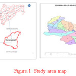
Geographical information system and remote sensing used Land use planning for conservation measures of Basin using Remote Sensing and GIS Approach of Sukhana Basin, which is divided into 35 sub watersheds of Aurangabad District, Maharashtra state. Study area is located between 75.33°, 75.76° E longitudes, and 19.66°, 19.98° N latitudes. Study area covers 93 villages. Study area is shown in Fig.1 and details of study area is given in table 1.
Table 1: Summary of study area
|
Name of watershed |
No of watershed |
Area of watershed In SqKm |
No .of villages covered |
|
AU/GP-10 |
09 |
351.75 |
52 |
|
AU/GP-17’ |
06 |
172.25 |
32 |
|
AU/GP-17 |
02 |
66.00 |
09 |
|
Total---03 |
17 |
590.00 |
93 |
 |
|
Data used
Spatial data consists of toposheets of Survey of India, satellite image and DEM of study area, state and district map for exact location of study area, Details of data shown in table 2.
Table 2: Details of data
|
Sr. No. |
Type of data |
Source |
|
1. |
Study area map |
Ground Water Survey Development Authority (GSDA) |
|
2. |
Toposheets |
Survey of India department |
|
3. |
Satellite image |
www.earthexplorer.in |
|
4. |
Soil type |
NBSS, Nagpur Maharashtra |
|
5. |
Precipitation |
www.globalweather.tamu.edu |
Determination of the land capability class
The common parameters such as soil texture, soil depth, slope and erosion, which are recorded on a survey map for land capability. The land is classified into capability classes according to each parameter with the help of table. 3. The capability class will be the higher number given to any of the properties according to severity of limitations.
Table 3: Land Capability Rating Table
|
Sr. No. |
Particular |
Class I |
Class II |
Class III |
Class IV |
Class V |
Class VI |
Class VII |
Class VIII |
|
1. |
Colour on map |
Green |
Yellow |
Red |
Blue |
Dark green |
Orange |
Brown |
Purple |
|
2. |
Soil texture |
Loam (L) |
Loam (L) |
Clay & loamy sand (LSC) |
Clay & Sand (CS) |
-- |
-- |
-- |
-- |
|
3. |
Soil depth |
Very deep (>90) d5 |
Deep (45-90) d4 |
Moderate (22.5-45) d3 |
Shallow (7.5-22.5) d2 |
Very deep (>90)d5 |
Very shallow (<7.5)d1 |
Very shallow (<7.5) d1 |
Rock |
|
4. |
Slope |
Nearly level (<1) (A) |
Gentle (1-3) (B) |
Moderate (3-5) (C) |
Strong (5-15) (D) |
Nearly level (<1) |
Steep (15-25) (E) |
Very steep (>25) |
-- |
|
5. |
Erosion |
None to slight (e1) |
Slight (e1) |
Moderate (e2) |
Severe (e3) |
None to slight |
Very severe (e4) |
Very severe (e5) |
-- |
(Source : E.M. Tideman, 2006) For example, the mapping symbol L-d4/A-e1 for which details are given in Table 4.
Table 4: Example of determine land class
|
Parameters |
Land capability class |
|
L = Loam (medium) |
I |
|
d4= soil depth |
II |
|
A = Slope, level (0-1%) |
I |
|
e1 = Erosion absent or very slight |
I |
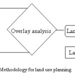
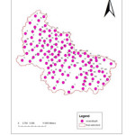
The capability of above class is II and its subclass is d4 (soil depth limitation) and its mapping symbol will be IIs. In this way mapping symbol is done for 113 locations in the basin. Procedure is shown in flow chart Fig.
 |
|
Result and Discussion
Slope
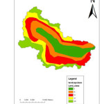
Slope map is shown in Fig.3 shows that maximum area 276.82 sq.Km. under category 1-3% slope which is about 41% , following 159 sq.Km. under 3 to 5% which is about 24% of total area of the basin minimum area of 19.85 sq.Km. found in the category of 15-25%.
Erosion
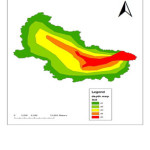
As shown in Fig.4, areal extent for moderate erosion found to be 285 sq.Km. and severe erosion 116.84 sq.Km. which account 18% of the total area of the basin veryslight and slight erosion accounted is 151 sq.Km. and 115 sq.Km.
Soil
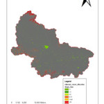
Deep and moderately well drained soil is about 341.75 sq.Km. which is 51% of the total area following shallow loam soil about 270 sq.Km. and very shallow loamy soil about 56.78 sq.Km. which account 40% and 9% respectively very shallow soil observed on upper reach near ridge line. Soil map is shown in Fig. 5.
Soil depth
It is observed that 209.84 sq.Km. area is under very shallow depth less than 7.5 cm. Moderate depth about 146.76 sq.Km. and deep soil area extent is 73.71 sq.Km as shown in Fig.6.
Land capability class
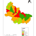
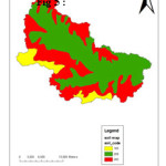
Details of land capability classification is shown in table 5 with symbol of class and its limitation. Various points for which land class symbol is found is shown in fig.7. From table 6, it shows that land class II, III, IV, VI and VII are present in the basin. Land class IV is dominant class with respect to areal extent in the basin, which is account for 165.80 sq.Km. (24.82%), other classes II,III, VI, and VII covers area 20.12%, 22.47%, 15.22% and 17.46% respectively as shown in Fig.8.
Table 5: Details of Land capability classification
|
Point _ id |
Symbol |
class_ e |
class_ d |
class_ s |
class_ slope |
land_ class |
Limitation |
|
0 |
e4-d1/ls-F |
IV |
VI |
III |
VII |
VII |
slope |
|
1 |
e4-d1/cs-F |
IV |
VI |
IV |
VII |
VII |
slope |
|
2 |
e4-d2/scl-B |
IV |
IV |
II |
II |
IV |
depth,erosion |
|
3 |
e4-d2/cs-E |
IV |
III |
IV |
VII |
VII |
slope |
|
4 |
e4-d3/scl-D |
IV |
III |
II |
IV |
IV |
slope,erosion |
|
5 |
e4-d4/ls-A |
IV |
II |
III |
I |
IV |
erosion |
|
6 |
e4-d1/ls-F |
IV |
VI |
III |
VII |
VII |
slope |
|
7 |
e4-d1/scl-B |
IV |
VI |
II |
II |
VI |
depth |
|
8 |
e4-d1/ls-C |
IV |
VI |
III |
III |
VI |
depth |
|
9 |
e4-d2/ls-B |
IV |
IV |
III |
II |
IV |
depth,erosion |
|
10 |
e4-d2/scl-C |
IV |
IV |
II |
III |
IV |
depth,erosion |
|
11 |
e3-d1/cs-F |
III |
VI |
IV |
VII |
VII |
slope |
|
12 |
e3-d1/cs-F |
III |
VI |
IV |
VII |
VII |
slope |
|
13 |
e3-d1/cs-F |
III |
VI |
IV |
VII |
VII |
slope |
|
14 |
e3-d1/ls-E |
III |
VI |
III |
VII |
VII |
slope |
|
15 |
e3-d1/cs-E |
III |
VI |
IV |
VII |
VII |
slope |
|
16 |
e3-d1/ls-F |
III |
VI |
III |
VII |
VII |
slope |
|
17 |
e3-d1/ls-D |
III |
VI |
III |
IV |
VI |
depth |
|
18 |
e3-d1/scl-C |
III |
VI |
II |
III |
VI |
depth |
|
19 |
e3-d1/ls-F |
III |
VI |
III |
VII |
VII |
slope |
|
20 |
e3-d1/ls-F |
III |
VI |
III |
VII |
VII |
slope |
|
21 |
e3-d1/ls-D |
III |
VI |
III |
IV |
VI |
depth |
|
22 |
e3-d1/ls-F |
III |
VI |
III |
VII |
VII |
slope |
|
23 |
e3-d1/ls-F |
III |
VI |
III |
VII |
VII |
slope |
|
24 |
e3-d1/ls-E |
III |
VI |
III |
VII |
VII |
slope |
|
25 |
e3-d2/ls-B |
III |
IV |
III |
II |
IV |
depth |
|
26 |
e3-d2/ls-F |
III |
IV |
III |
VII |
VII |
slope |
|
27 |
e3-d2/ls-C |
III |
IV |
III |
III |
IV |
depth |
|
28 |
e3-d2/ls-F |
III |
IV |
III |
VII |
VII |
slope |
|
29 |
e3-d2/ls-E |
III |
IV |
III |
VII |
VII |
slope |
|
30 |
e3-d2/cs-E |
III |
IV |
IV |
VII |
VII |
slope |
|
31 |
e3-d2/ls-E |
III |
IV |
III |
VII |
VII |
slope |
|
32 |
e3-d2/ls-B |
III |
IV |
III |
II |
IV |
depth |
|
33 |
e3-d2/scl-B |
III |
IV |
II |
II |
IV |
depth |
|
34 |
e3-d2/ls-B |
III |
IV |
III |
II |
IV |
depth |
|
35 |
e3-d2/scl-D |
III |
IV |
II |
IV |
IV |
depth,slope |
|
36 |
e3-d2/ls-D |
III |
IV |
III |
IV |
IV |
depth,slope |
|
37 |
e3-d2/scl-B |
III |
IV |
II |
II |
IV |
depth |
|
38 |
e3-d2/scl-C |
III |
IV |
II |
III |
IV |
depth |
|
39 |
e3-d2/ls-D |
III |
IV |
III |
IV |
IV |
depth,slope |
|
40 |
e3-d2/scl-C |
III |
IV |
II |
III |
IV |
depth |
|
41 |
e3-d2/ls-D |
III |
IV |
III |
IV |
IV |
depth,slope |
|
42 |
e3-d2/ls-B |
III |
IV |
III |
II |
IV |
depth |
|
43 |
e3-d3/scl-B |
III |
III |
II |
II |
III |
depth,erosion |
|
44 |
e3-d4/scl-B |
III |
II |
II |
II |
III |
erosion |
|
45 |
e3-d3/scl-C |
III |
III |
II |
III |
III |
depth,erosion.slope |
|
46 |
e3-d3/scl-C |
III |
III |
II |
III |
III |
depth,erosion.slope |
|
47 |
e3-d3/ls-E |
III |
III |
III |
VI |
VI |
slope |
|
48 |
e3-d3/ls-E |
III |
III |
III |
VI |
VI |
slope |
|
49 |
e3-d3/scl-A |
III |
III |
II |
I |
III |
depth,erosion |
|
50 |
e3-d4/scl-A |
III |
II |
II |
I |
III |
erosion |
|
51 |
e3-d3/scl-B |
III |
III |
II |
II |
III |
depth,erosion |
|
52 |
e3-d3/scl-B |
III |
III |
II |
II |
III |
depth,erosion |
|
53 |
e3-d2/ls-B |
III |
IV |
III |
II |
IV |
depth |
|
54 |
e3-d3/ls-D |
III |
III |
III |
IV |
IV |
slope |
|
55 |
e3-d4/scl-B |
III |
II |
II |
II |
III |
erosion |
|
56 |
e3-d5/scl-A |
III |
I |
II |
I |
III |
erosion |
|
57 |
e3-d4/scl-D |
III |
III |
II |
IV |
IV |
depth |
|
58 |
e2-d5/scl-B |
II |
I |
II |
II |
II |
erosion,soil,slope |
|
59 |
e2-d1/ls-D |
II |
VI |
III |
IV |
VI |
depth |
|
60 |
e2-d1/ls-D |
II |
VI |
III |
IV |
VI |
depth |
|
61 |
e2-d2/scl-D |
II |
IV |
II |
IV |
IV |
depth,slope |
|
62 |
e2-d3/ls-E |
II |
III |
III |
VI |
VI |
slope |
|
63 |
e2-d3/scl-A |
II |
III |
II |
I |
III |
depth |
|
64 |
e2-d2/ls-E |
II |
IV |
III |
VII |
VII |
slope |
|
65 |
e2-d3/ls-B |
II |
III |
III |
II |
III |
depth,soil |
|
66 |
e2-d3/scl-C |
II |
III |
II |
III |
III |
depth,slope |
|
67 |
e2-d3/ls-B |
II |
III |
III |
II |
III |
depth,soil |
|
68 |
e2-d1/ls-D |
II |
VI |
III |
IV |
VI |
depth |
|
69 |
e2-d1/scl-D |
II |
VI |
II |
IV |
VI |
depth |
|
70 |
e2-d1/scl-D |
II |
VI |
II |
IV |
VI |
depth |
|
71 |
e2-d1/scl-E |
II |
VI |
II |
VI |
VI |
depth,slope |
|
72 |
e2-d1/scl-E |
II |
VI |
II |
VI |
VI |
depth,slope |
|
73 |
e2-d1/ls-F |
II |
VI |
II |
VII |
VII |
slope |
|
74 |
e2-d1/ls-F |
II |
VI |
II |
VII |
VII |
slope |
|
75 |
e2-d2/ls-D |
II |
IV |
II |
IV |
IV |
depth,slope |
|
76 |
e2-d3/scl-D |
II |
III |
II |
IV |
IV |
slope |
|
77 |
e2-d4/scl-C |
II |
II |
II |
II |
II |
erosion,depth,soil,slope |
|
78 |
e2-d4/scl-C |
II |
II |
II |
II |
II |
erosion,depth,soil,slope |
|
79 |
e2-d4/scl-C |
II |
II |
II |
III |
III |
slope |
|
80 |
e2-d4/scl-B |
II |
II |
II |
II |
II |
erosion,depth,soil,slope |
|
81 |
e2-d2/scl-D |
II |
IV |
II |
IV |
IV |
depth,slope |
|
82 |
e2-d3/scl-B |
II |
III |
II |
II |
III |
depth |
|
83 |
e2-d2/ls-E |
II |
IV |
III |
VI |
VI |
depth,slope |
|
84 |
e2-d2/ls-D |
II |
IV |
III |
IV |
IV |
depth,slope |
|
85 |
e2-d3/scl-B |
II |
III |
II |
II |
III |
depth |
|
86 |
e1-d2/scl-C |
I |
IV |
II |
III |
IV |
depth |
|
87 |
e1-d3/scl-B |
I |
III |
II |
II |
III |
depth |
|
88 |
e1-d3/scl-C |
I |
III |
II |
III |
III |
depth,slope |
|
89 |
e1-d3/scl-C |
I |
III |
II |
III |
III |
depth,slope |
|
90 |
e1-d3/scl-C |
I |
III |
II |
III |
III |
depth,slope |
|
91 |
e1-d3/scl-C |
I |
III |
II |
III |
III |
depth,slope |
|
92 |
e1-d4/scl-B |
I |
II |
II |
II |
II |
depth,soil,slope |
|
93 |
e1-d4/scl-B |
I |
II |
II |
II |
II |
depth,soil,slope |
|
94 |
e1-d4/scl-A |
I |
II |
II |
I |
II |
depth,soil |
|
95 |
e1-d1/ls-E |
I |
VI |
III |
VI |
VI |
slope |
|
96 |
e1-d3/scl-D |
I |
III |
II |
IV |
IV |
slope |
|
97 |
e1-d3/scl-B |
I |
III |
II |
II |
III |
depth |
|
98 |
e1-d4/scl-D |
I |
II |
II |
IV |
IV |
slope |
|
99 |
e1-d4/scl-B |
I |
II |
II |
II |
II |
depth,soil,slope |
|
100 |
e1-d5/scl-A |
I |
I |
II |
I |
II |
soil |
|
101 |
e1-d5/scl-A |
I |
I |
II |
I |
II |
soil |
|
102 |
e1-d5/scl-A |
I |
I |
II |
I |
II |
soil |
|
103 |
e1-d5/scl-A |
I |
I |
II |
I |
II |
soil |
|
104 |
e1-d1/scl-D |
I |
VI |
II |
IV |
VI |
depth |
|
105 |
e1-d2scl-D |
I |
IV |
II |
IV |
IV |
depth,slope |
|
106 |
e1-d4/scl-A |
I |
II |
II |
I |
II |
depth,soil |
|
107 |
e1-d4/scl-A |
I |
II |
II |
I |
II |
depth,soil |
|
108 |
e1-d3/ls-B |
I |
III |
III |
II |
III |
depth,soil |
|
109 |
e1-d3/scl-D |
I |
II |
II |
II |
II |
depth,soil,slope |
|
110 |
e1-d5/scl-D |
I |
I |
II |
IV |
IV |
slope |
|
111 |
e1-d5/scl-D |
I |
I |
II |
IV |
IV |
slope |
|
112 |
e1-d5/scl-D |
I |
I |
II |
IV |
IV |
slope |
From above table it is found that out of 113 locations class II, III, IV, VI, and VIII are available at 15, 24, 33 ,18 and 23 locations respectively.
Table 6: Land capability classification in the basin
|
Sr. No. |
Area |
Symbol |
|
1 |
134.4151 |
II |
|
2 |
150.1243 |
III |
|
3 |
165.8045 |
IV |
|
4 |
101.6851 |
VI |
|
5 |
116.6801 |
VII |
 |
|
 |
|
 |
|
 |
|
 |
|
 |
|
Conclusion
The analysis shows that shows that land class II, III, IV, VI and VII are present in the basin. Class suitable for cultivation are II, III and IV have areal extent 134.41, 150.12 and 165.80 sq.Km. which is 67.32% of the total basin area and class VI and VII are not suitable for cultivation has areal extent 101.68 respectively which is 32.68% of the total area. Based on land capability classification land use planning with reference to conservation planning for Class II,III,IV are gully control measures, farm bunding such as compartment bunding, contour bunding and graded bunding. Whereas, for class VI measures are continuous contour trenches and staggered trenching and for class VII treatment propose a pasture development.
Acknowledgement
The Author is grateful to Dr. K. A. Patil, Guide and Head of the Department of Civil Engineering, Government Engineering College Aurangabad and sincerely thankful to Authority of Vasantrao Naik Marathwada Krishi Vidyapeeth Parbhani for valuable support during study.
References
- Tideman E.M.(2006) Watershed Management ,Guidelines for Indian Conditions,Omega Scientific Publishers,New Delhi.
- Gizachew Tiruneh . Land capability classification using geographical information system in shinfa watershed, highlands of Ethiopia. Journal of Physical Science and Environmental Studies , 1 (2) :17-20 (2015).
- Halus Satriawan, Erwin Masrul Harahap, Rahmawaty, Abubakar Karim . Land Capability Evaluation for Agriculture in Krueng Sieumpo Watershed. Academic Research International , 5 (3):55-63 (2014).
- Ali R.R. and M.M. Kotb . Use of Satellite Data and GIS for Soil Mapping and Capability Assessment. Nature and Science, 8 (8) :104-115(2010).
- Malini Roy Choudhury and Sumanta Das . An Integrated Geo-Spatial Studies for Land Capability Assessment of Agricultural Field Especially for Paddy Cultivation. Asian Journal of Geoinformatics, 15(2):22-31(2015).
- Sumbangan Baja, David M. Chapman Deirdre Dragovich. A Conceptual Model for Defining and Assessing Land Management Units Using a Fuzzy Modeling Approach in GIS Environment. Environmental Management , 29 (5) :647–661(2002)
CrossRef - Sachin Panhalkar . Land capability classification forintegrated watershed development by applying remote sensing and Gis techniques. ARPN journal of Agricultural and biological science ,6 (4) :46-55(2011).
- Jacek Malczewski . GIS-based land-use suitability analysis: a critical overview. Progress in Planning 62 : 3–65(2014).
CrossRef - Appala N. Raju. Land Capability and Suitability in Vizianagaram district of Andhra Pradesh using Remote sensing and GIS Techniques,” IOSR Journal Of Humanities And Social Science (IOSR-JHSS), 20 ( 7): PP 56-64 (2015)
- Vikhe, S.D., Dr. K.A. Patil . State of the Art of Land Use Planning Using Remote Sensing and GIS .IOSR Journal of Mechanical and Civil Engineering (IOSR-JMCE) e-ISSN: 2278-1684,p-ISSN: 2320-334X, 11( 5): 41-4(2014).
- Chanhda, H., WU. Ci-fang, YE. ,Yan-mei, Y. Ayumi. GIS based land suitability assessment along Laos- China border. Journal of Forestry Research 21(3): 343-349(2010)
CrossRef - Fang Qiu, Bryan Chastain, Yuhong Zhou Caiyun Zhang, Harini Sridharan. Modeling land suitability/capability using fuzzy evaluation . Geo Journal DOI 10.1007/s10708-013-9503-0 (2013).
CrossRef - Gizachew Ayalew and Tiringo Yilak . A GIS based Land Capability Classification of Guang Watershed, Highlands of Ethiopia. Journal of Environment and Earth Science , 4 (22) :161-166(2014)
- Mokarrama, M , F. Aminzadeh, Gis-Based Multicriteria “Land Suitability Evaluation Using Ordered Weight Averaging With Fuzzy Quantifier: A Case Study In Shavur Plain,Iran”. The International Archives of the Photogrammetry, Remote Sensing and Spatial Information Sciences, 38 (II) :508-512.
- Sachin, S. Panhalkar., Sagar, P., Mali, C.T. Pawar. Land Capability Classification in Hiranyakeshi Basin of Maharashtra (India): A Geoinformatics Approach. International Journal of Engineering and Technical Research (IJETR) ISSN: 2321-0869, 2 (6) :18-21(2014).


