Morphometric Analysis of Kadvi River Basin, Maharashtra Using Geospatial Techniques
Sujit S Chougale 1
and Jagdish B Sapkale 1
*

1
Department of Geography,
Shivaji University,
Kolhapur,
Maharashtra,
India
http://dx.doi.org/10.12944/CWE.12.3.15
The present research work reflects the in detail morphometric study of Kadvi river basin, which is a part of Warna river in Shahuwadi district. Considering the geospatial techniques the study of kadvi river has further proceeded. The CARTOSAT data was used for generating DEM (digital elevation model).GIS was used for the analysis of morphometric aspects of Kadvi river basin. In the present study a variety of parameters like linear (stream number, stream order, stream length, stream length ratio, drainage density, bifurcation ratio, texture ratio, stream frequency) and shape concepts ( i.e. compactness-coefficient, circularity ratio , elongation ratio, form factors ) of the kadvi river basin has estimated. The study concludes that Kadvi river basin is having an area of 428.82 square km. The obtained number of stream order is from 1 to 7, here it is proved that 1st stream order with 1488 stream number is most dominant. The total number of streams counted in the Kadvi river basin are 1948. The drainage texture obtained in the basin is 18.07, which shows very fine texture of the river basin. The measured drainage density and stream frequency values are 3.2 km/sq.km and 4.54 respectively.
Copy the following to cite this article:
Chougale S. S, Sapkale J. B. Morphometric Analysis of Kadvi River Basin, Maharashtra Using Geospatial Techniques. Curr World Environ 2017;12(3). DOI:http://dx.doi.org/10.12944/CWE.12.3.15
Copy the following to cite this URL:
Chougale S. S, Sapkale J. B. Morphometric Analysis of Kadvi River Basin, Maharashtra Using Geospatial Techniques. Curr World Environ 2017;12(3). Available from: http://www.cwejournal.org/?p=17815
Download article (pdf) Citation Manager Publish History
Introduction
Morphometric studies are first attempted by Horton, Strahler, Smith, Schumm, and Miller1-5. Parallel work of basin morphometry has been carried out by Abrahams, Langbein, Leopold, and Maddock6-8. The morphometric analysis is done with linear, aerial, relief aspect, the slope, and a gradient of a channel by many researchers9,10. Basin morphometry gives the signs of an influence on river hydrology and river channel. Similar work is done by Sapkale on Tarali river with an approach of hydraulic geometry and river channel processes11-13. The main aim of the attempted study is the analysis of morphometric parameters of Kadvi river watershed with an approach of GIS and remote sensing. Nowadays GIS techniques are more useful for assessment of various morphometric and terrain parameters of a watershed. GIS offer high accuracy level, flexibility in work as well as this is a user friendly tool. DEM data has used for terrain analysis of Kadvi river watershed. DEM data is employed for flow direction, flow accumulation, slope map, aspect map, contour map and other morphometric parameters like basin relief, relief ratio, absolute relief, watershed slope etc. Many researchers also used GIS and remote for evaluating morphometry of river watersheds14-22. Morphometric study of watershed gives information which is related to terrain, hydrological characteristics of the river, physiography of basin which is helpful for river water management, irrigation and site suitability for reservoirs. The deforestation ,erosion of landscape due to over-exploiting of top soil and land cover changes are also the human induced impacts that is highly influenced on the morphometric characteristics of river basin. Kadvi river basin also reflects such type of human interferences, which are responsible for the changing characteristics of river basin morphometry. Fundamental mophometric parameters like drainage density, slope, run off, texture, relief ratio have also expresses hydrological characteristic of the basin, also helps to evaluate the potential sites of ground water zones in terms of geo-hydrologic aspects. The analysis of morphometric aspects may supports for the study of hydrological models by means of remote sensing and GIS techniques.
Study Area
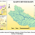
The Kadvi River basin extend between 16°48' 51.369" to 17° 3' 5.686" north latitudes and 73°45' 58.957" to 74° 05' 35.303" east longitudes. Kadvi river basin area covers 428.81 sq km with reference to SOI toposheets 47G16, 47H13 and 47L1. Kadvi river originated in western ghat near Amba village, Shahuwadi, Kolhapur, Maharashtra, India. Kadvi river is the main tributary of Warna river. Kadvi river flows western to the eastern side and meets the Warna river near Thergaon village23. Ambardi, Potphogi, and Shali rivers are sub tributaries of Kadvi river. Length of Kadvi river is 48.66 km. Kadvi river basin covers nearly 41.50% area of Shahuwadi tehsil, so Kadvi river is known as the back bone of Shahuwadi tehsil. The climate of Basin is generally temperate24. Heavy rainfall is found in this basin from June to October25.
 |
|
Materials and Methods
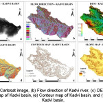
Morphometric analysis of river does not possible without SOI toposheets or satellite imageries. In this present work SOI toposheets 47G16, 47H13 and 47L1 on the scale of 1:50000 were used. Georeferencing process is done by Erdas Imagin 9.1. Letter on digitization process and calculations are prepared on Arc GIS 9.3. The morphometric analysis conveyed through linear aspects, areal aspects and relief aspects. Basin area of Kadvi river basin and drainage network has computed on the basis of SOI toposhets (Fig 1). Strahler’s stream ordering method adopted for stream ordering of Kadvi river basin. Cartosat DEM images were used for flow direction map, DEM map, slope map, aspect map and contour map.
 |
|
Results and Discussion
Stream order
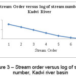
The first step of morphometric analysis of the river basin is to get the Stream order. It is identified as calculating the arrangement of a stream in the hierarchy of streams and tributaries26. Stream ordering method was first invented by Horton27 in 1945, but later on in 1952 Strahler28 has modified stream ordering method and published it. Strahler method is much uncomplicated so generally many researchers adopt this method for morphometry purpose. In this present work, Strahler’s method is used for stream ordering. And the result is that Kadvi river is ended by 1948 streams linked with 1st to 7th stream orders.
Number of streams (Nu)
The number of stream segments in specific order is estimated individually and is called as stream number of that particular order. Horton27 invented the number of stream segments. The number of stream decrease with increasing stream order. The negative relationship has detected between stream order and numbers of the stream to the respective order.
All the stream of the watersheds of Kadvi river basin has been designated according to the Strahler’s system. As per the law of Strahler in Kadvi river basin, the first order constitutes 76.39 %, while the second is 17.97 % of the total number of streams. The 3rd, 4th, 5th, 6th, 7th streams covers 4.26 %, 0.98 %, 0.26 %, 0.10 %, 0.05 % respectively of the total number of streams. A high value of first order streams indicates that there is a possibility of serious flood after heavy rainfall in the downstream29.
 |
|
Stream length (lu)
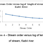
Stream length means the total length of streams in each particular order is approved to as stream length of that order. In this study, the law of Horton has followed for calculating the stream length. Frequently the total length of stream sections is maximum for the first order stream and decrease with stream order increase. This may be due to the flowing of streams from high elevation, change in rock and soil type and moderately steep slopes and probably uplift across the basin30, 31.
It can be measured the fact from table 1 that the length of 1st order is measured to be 60.61% of total stream length. 2nd order stream has 21.04% length. 3rd order constitutes about 9.39% length. 4th order has 3.92% length. 5th order has 2.12% length. 6th and 7th order measured 1.50% and 1.42% length respectively. The result disclosed that 1st order stream is available with a large number but short in length and basically found in an upstream area.
 |
|
Stream length ratio (Lurm)
Horton27 has identified the concept of mean stream length. Lurm, is the ratio between any two successive orders of mean stream length. Change of Lurm, from one order to another order representing their late youth stage of geomorphic development. Variations are observed in stream length ratio between adjacent stream orders of the basin due to disparity in slope and topographic conditions. The value of stream length ratio varies arbitrarily from 1.48 to 2.05 found in Kadvi river. It reveals that hard terrain is dissected and controlled by rock structure and the streams have limited length of lower order stream.
Mean stream length (Lum)
Lum, is a dimensional property exhibiting the characteristic size of components of a drainage system and its contributing watershed area. Kadvi River shows 0.56 to 19.42 mean stream length value. The mean stream length of Kadvi river is 0.56 for 1st order, 0.82 for 2nd order, 1.55 for 3rd order, whereas 4th, 5th, 6th, the 7th order has 2.83, 5.81, 10.26, 19.42 respectively. The Lum of the river increases with the increase of the order it means that positive relationship is found between Lum and stream order. The average mean stream length of Kadvi River is 1.82.
Bifurcation Ratio (Rb)
The Rb, is the 'ratio between the numbers of streams in two successive orders'. Schumm formulates the concept of bifurcation ratio32. In conformity with Schumm ‘The term bifurcation ratio is the ratio of the number of stream segments of any given order to the number of streams in the next higher order’ 32. These irregularities are dependent on the geological and lithological progress of the drainage basin 32. Bifurcation ratio of Kadvi river varies from 2 to 4.37. The lower values of bifurcation ratio indicate that the watersheds have undergone less structural disturbance. In this research work, it is clear that bifurcation ratio with higher values are indicative of having strong structural control on the drainage pattern, where as the bifurcation ratio with lower value shows watershed that is not affected by structural disturbance.
Mean Bifurcation Ratio (Rbm)
Value of mean bifurcation ratio of Kadvi river is 3.52. Higher ''Rbm'' of river basin means large variation in a number of stream orders because of more complex geological structure33.
Weighted mean bifurcation ratio (Rbwm)
Strahler in 1953 used a Rbwm, considered an outcome of bifurcation ratio for each successive pair of order and the total number of stream involved in the ratio and taking the mean of the sum of these values. The values thus determined are very close to each other. The Rbwm of Kadvi river obtained by this method is 4.24.
Table 1: Stream order, Number of streams, Bifurcation ratio, Total length of streams, Stream length ratio, Log of Nu and Log of Lu
|
Stream Order |
Number of Streams |
Bifurcation Ratio |
Total Length of Streams (km) |
Mean Stream Length (km) |
Stream Length ratio |
Log Nu |
Log Lu |
|
1 |
1488 |
4.25 |
830.90 |
0.56 |
1.48 |
3.17 |
2.92 |
|
2 |
350 |
4.22 |
288.46 |
0.82 |
1.88 |
2.54 |
2.46 |
|
3 |
83 |
4.37 |
128.72 |
1.55 |
1.83 |
1.92 |
2.11 |
|
4 |
19 |
3.80 |
53.80 |
2.83 |
2.05 |
1.28 |
1.73 |
|
5 |
5 |
2.50 |
29.04 |
5.81 |
1.77 |
0.70 |
1.46 |
|
6 |
2 |
2.00 |
20.52 |
10.26 |
1.89 |
0.30 |
1.31 |
|
7 |
1 |
--- |
19.42 |
19.42 |
--- |
0.00 |
1.29 |
|
Total |
1948 |
3.52 |
1370.85 |
5.89 |
1.82 |
Length of Main channel (Cl)
This is the distance along the largest water source from the outlet to end of channel boundary. In this study, length of the main channel is measured by taking help of Arc-GIS software. The calculation comes to 48.66 km of Kadvi river.
Channel Index (ci) and Valley index (vi)
Channel index of Kadvi river is calculated by dividing mean channel length of a river by minimum areal distance. The Channel Index (ci) of Kadvi river is 1.77. Estimation of valley index is performed by taking the ratio of valley length of the river to minimum areal distance, which is 1.3 obtained for Kadvi river basin.
Rho Coefficient
Rho coefficient parameter is strictly associated with drainage density to geologically progress of basin which evaluates the storage competence of drainage system and determinant of drainage improvement in a particular basin27. Rho coefficient value of Kadvi river is 0.52. Geological, geomorphological, climatic and biotic factors conclude the changes in Rho coefficient.
Length of Basin
Different meanings of basin length (lb) have been discussed by different researcher 32-36. With reference to Schumm, the length of Kadvi river basin seems to be 35.86 km. Basin length of Kadvi river was measured with Arc GIS software. Length of the basin is dependent on shape of basin. Elongated basin is characteristic of high basin length.
Sinuosity Index
It is the property of stream that shows the divergence of the river course of a drainage line from the straight path. Sinuosity index highly signifies in verifying the effect of terrain features on the river path and vice versa. The value 1.0 shows straight river course, values involving 1.0 to 1.5 indicates the sinuous shape of the stream and the values above 1.5 shows the meandering course26. Kadvi basin has 1.36 value which shows sinuous course.
Basin Area
It is a key parameter of morphometric analysis1-5. Basin area is any area of land where rainfall water collects and drains off into a river and other water bodies. Generally, topography of landform determined basin area of the river. Schumm had set the relation between basin area of the river and total stream length. Kadvi river basin covered 428.82 sq km. Basin area and shape of the basin are closely related to each other. Larger basin areas are more prone to flooding.
Basin Perimeters (P)
The perimeter of Kadvi river basin is estimated to be 107.8 km, which covers the most part of the Shahuwadi tehsil. The estimation is done using Arc GIS software (Table-2). Basin perimeter said to be the length of the watershed boundary in which catchment region is encircled when basin perimeter associated with basin area. The departure of the basin from a true circle can be calculated. Similarly, when associated with relief it gives the general steepness of the basin.
Length area Relation (Lar)
The concept of length area relation discovered by Hack in 1957. Length area relation value is calculated with following formula37-43.
Lar = 1.4 * A0.6
Lar value of Kadvi river basin is 53.15.
Lemniscate’s (K)
To obtain the gradient of the basin, Chorley put forth the lemniscates value35,36. Kadvi River basin has K value 3. The formula is expressed as
K= Lb2/4*A.
Here, Lb = basin length, A= Area of basin.
Form factor
Horton27 described form factor concept. Form factor expresses the ratio between the river basin and square of the basin length. If form factor of the basin is closer to zero is designate highly elongated shape and closer to 1 point to circular shape. Value of Rf is 0.25 indicate lower value and convey elongated shape another hand, rate of Rf is 0.78 show higher value and suggest perfect circular basin shape. The form factor of Kadvi river is 0.33. It means that Kadvi river basin having an elongated shape. Flood flows are easily spread out in an elongated basin more than the circular basin.
Elongation ratio
Elongation ratio1-5 means, the ratio between the diameter of the circle of the same area as the drainage basin and the maximum length of the basin. Re, state with the following formula-
Re = 2 / Lb * (A / π) 0.5
Values of Re are classified into five classes, these are 0.9 to 0.10 is circular, 0.8 to 0.9 is oval, 0.7 to 0.8 is less elongated, 0.5 to 0.7 is elongated and below 0.5 is more elongated. Values closer to 1.0 is demonstrated region having very low relief. The value of elongation ratio of Kadvi river is 0.65 and designate low relief with an elongated shape.
Texture Ratio (Rt)
Texture ratio1-8 is a highlighting component in the drainage morphometric analysis which is defined as the ratio of first order streams and perimeter of the basin. The present study shows 13.8 as the texture ratio of a watershed and classified as moderate in nature. It is dependent on various natural factors like climate, rainfall, vegetation, rock and soil type, infiltration capacity and developmental stage.
Circulatory ratio
Miller described circularity ratio concept in 1953. According to Miller circularity ratio means the ratio of the area of basin to the perimeter of the same basin37. Rc of the basin is express with following formula -
Rc = 4 π* (A /P2)
Miller has described, the basins having 0.4 to 0.5 circularity ratios specify highly elongated and homogeneous geological structures. Values of circularity ratios are between 0 (in line) to 1 (in a circle). Variations in circularity ratios found due to relief pattern, variety in a slope of the basin. A low value of circularity ratio indicates youth stage and medium and high values shows mature and old stage of river respectively. Kadvi river basin illustrates the mature stage of development with the Rc of 0.46. Kadvi River basin has a highly elongated shape as per law of Miller 37.
Drainage texture
Horton27 invent drainage texture concept and defined drainage texture is the total number of stream numbers of all order in a basin per perimeter of the basin. Smith 38 has classified five classes for drainage texture i.e., below 2 for very coarse, 2 to 4 for coarse, 4 to 6 for moderate, 6 to 8 for fine and above 8 for very fine38. Drainage texture of basin is depending on rainfall, vegetation cover, climatic condition, soil types, rock formation and relief of the basin. In this present work, the basin of Kadvi river reveals very fine drainage texture with a greater value which is 18.07 by the collective result of various geomorphological and geological processes.
Compactness coefficient (Cc)
As per the law of Gravelius 44, compactness coefficient of a watershed is referred as the ratio of the perimeter of a watershed to a circumference of the circular area, which equals the slope, not on the size of a watershed. Compactness coefficient is measured by considering the formula.
Cc = 0.2841 * P /A 0.5
The Compactness coefficient of Kadvi watershed is estimated to 1.48. For a perfect circle, Compactness coefficient is measured to be unity and is directly proportional to basin length. It direct related with elongated nature of the basin.
Fitness ratio (Rf)
According to Melton47, fitness ratio is illustrated as the ratio of main channel length to the length of the watershed perimeter. For various studies fitness ration has carried out by distinguished authors 45-51. It is a measure of topographic fitness ratio, for Kadvi river basin it is 0.45.
Wandering Ratio (Rw)
Smart and Surkan48 defined wandering ratio of main stream length to the valley length. The actual distance between the outlet of the basin and the extreme point on the ridge is the length of the valley. The wandering ratio of Kadvi river drainage basin is 1.36.
Stream frequency (Fs)
In 1932, Horton1-8 invented the concept of stream frequency. According to him, stream frequency is a ratio of total numbers of streams of all orders of the basin divided by total area of the basin. Stream frequency and Drainage density are closely related to each other and designated if stream frequency increases, respectively drainage density also increases (Table-2). The steep slope and impervious soil and loose rock structure are causes of high stream frequency1-8. As well as stream frequency is also reliant on rainfall and geology of watershed. Kadvi river basin frequently covered with the hilly region so moderate stream frequency is found in this basin and it is 4.54.
Drainage density (Dd)
Horton has introduced the drainage density first, then later on various researchers1-8 have calculated the drainage density for the river basins. Drainage density is the ratio of the length of total streams of the basin divided by total area of the basin. Dd is measured in mi/sq. mi or km/sq. km. Low drainage density indicates coarse drainage texture while high drainage density reveals the fine drainage texture1-8. Drainage density is classified in five categories39, very coarse for below 2, coarse for 2 to 4, moderate for 4 to 6, fine for 6-8 and very fine for above 8. Drainage density of Kadvi river is 3.2 km/sq. km. It is recommended coarse drainage density. High drainage density is found in a hilly region of the basin in a site of SW and S40. Dd is a very sensible parameter and closely related to rainfall, vegetation, soil structure, geology, rock formation, land use and land cover and some other morphometric parameters. Drainage density is positively correlated with stream frequency. This positive relation between drainage density and stream frequency develop the drainage capacity of the watershed.
Constant channel maintenance
The inverse of drainage density or the constant of channel maintenance as a property of landform was given by Schumm in 1956. The constant of channel maintenance indicates the relative size of landform units in a drainage basin and has a specific genetic connotation 1-8. It consist the dimensions of length and therefore shows a directly proportional relation with the scale of landform unit. The constant ‘C’ provides necessary data of the number of square feet of watershed surface needed to sustain one linear foot of stream1-8, 19, 33, 49. Constant of channel maintenance is a function of ground permeability. Relatively high constant channel maintenance is seen in alluvial and the piedmont area basin. Channel maintenance for Kadvi basin is found to be 0.31 km2. Higher is the value for the constant channel, stronger the lithology control and higher the permeability8. The elements that alter the constant of maintenance other than permeability are rock type, relief, vegetation and duration of rainfall.
Drainage intensity
Drainage intensity illustrated by Faniran 45, that it is a ratio of stream frequency to the drainage density. This study reflects a low drainage density of l.42 for Kadvi watershed . Drainage density and drainage intensity are negatively co-related with each other. Higher drainage density indicates low drainage intensity and low drainage density shows higher intensity. Low drainage intensity proves that drainage density and stream frequency have very less effect on the basin surface by the denudational process45-51. Low surface runoff is the key characteristic of low drainage density, stream frequency, and drainage intensity, and effect of flood disaster, land sliding, and marsh land is occurring.
Infiltration number
The product of drainage density (Dd) and drainage frequency (fs) is termed as infiltration number. The moderate infiltration number i.e. 14.53 is shown by Kadvi river basin. When there is higher infiltration number, low infiltration and higher run off is seen, leading to the construction of higher drainage density. This also reveals the impermeable lithology and higher relief in the basin 49.
Relief ratio
Schumm32 has defined the relief ratio concept. According to him, the relief ratio is a ratio of total relief of basin to the basin length of the same basin. The Relief ratio of Kadvi river basin is 0.013, which indicates moderate relief basin with a moderate slope.
Absolute relief (Ra)
Absolute relief is illustrated as the elevation difference between a given location and sea level. The estimated absolute relief for the full kadvi river is 1027mt.
Relative relief (Rhp)
Relative relief is termed as the total relief (H) divided by the perimeter (P) of the watershed. Given by expression Rhp = H/P. But Melton47 estimated it by using; Rhp = (H*100)/P. The relative ratio calculated for Kadvi river is 0.44. Here low relief ratio implies gentle topography and higher relief ratio point’s steep slope.
Dissection index (Dis)
Dissection index is computed by total basin relief divided by absolute relief with the following formula.
Dis = H / Ra
Dis value normally differs between 0 (complete lack of dissection) to 1.0 (vertical cliff at sea level). The measured Dis values for kadvi river basin it is 0.46. It expressed that Kadvi basin combines with the hilly region with a steep slope.
Gradient ratio (Rg)
Gradient ratio is the ratio of total basin relief divided by basin length. It is similar to relief ratio. Sreedevi50 has illustrates gradient ratio as an indicator of channel slope, which enables assessment of the runoff volume. In the study area, the computed gradient ratio for the kadvi river basin is 0.013.
Ruggedness number (Rn)
According to Strahler1-8 when the maximum basin relief is multiplied with drainage density the result is the ruggedness number. Based on this the estimated ruggedness number for full kadvi is 1.53.
Melton ruggedness number (MRn)
According to Melton, the MRn is a slope index that provides a specialized representation of relief ruggedness within the watershed 47. The estimated MRn for the kadvi river basin is 23.03.
Conclusion
The present study of Kadvi river basin - morphometry has attempted by by means of Remote sensing and GIS techniques. This modern techniques offer more accuracy for the investigation of morphometric features of the river basin. Kadvi River is having 1st to 7th stream orders, but lower order streams mainly control the basin (Table-1). Form factor, elongation ratio, and circularity ratio shows an elongated shape of Kadvi river basin with moderate run off. Stream frequency and drainage density are key parameters of watershed morphometry because they are related to runoff, infiltration, sediments and other hydrological parameters. Coarse drainage density is found in Kadvi river basin which as 3.2 km/km2. Herringbone, dendritic, rectangular drainage pattern and radial pattern is shown in this basin. This study is useful for the development of the Kadvi river basin in view of watershed management. Considering the estimated morphometric data of the river basin the irrigation facilities and agricultural processes can be attempted and controlled scientifically.
Acknowledgment
The Authors of this research paper would like to express their sincere thanks to DST-FIST and Shivaji University, Kolhapur for providing the Remote Sensing data and Computer Lab facilities for this research paper.
References
- Strahler, A. N. Quantitative geomorphology of drainage basins and channel networks. In: Chow, V. T. (ed), Handbook of applied hydrology, McGraw Hill Book Company, New York, Section, 4-11 (1964).
- Smith, G. H. The Morphometry of Ohio: The Average Slope of the Land (abstract). Annals of the Association of American Geographers, 29-94 (1939).
- Schumm, S. A. The relation of Drainage Basin Relief to Sediment Loss. International Association of Scientific Hydrology, 36: 216-219 (1954).
- Schumm, S. A. Sinuosity of Alluvial Rivers on the Great Plains. Bulletin of the Geological Society of America, 74: 1089-1100 (1963).
- Smith, K. G. Erosional processes and landforms in badlands national monument, South Dakota. Geol Soc Am Bull, 69: 975–1008 (1950).
- Abrahams, A. D. Channel networks: a geomorphological perspective. Water Resour Res, 20: 161–168 (1984).
- Leopold, L. B., Maddock, T. The hydraulic geometry of stream channels and some physiographic implications. USGS professional paper, 252: 1-57 (1953).
- Langbein, W. B. Topographic characteristic of drainage basins. USA: US Government Printing Office, 125-157 (1947).
- Nag, S. K. Morphometric analysis using remote sensing techniques in the Chaka sub-basin, Purulia district, West Bengal. Indian Soc. Remote Sensing, 26(1): 69-76 (1998).
- Magesh, N. S., Jitheshlal, K. V., Chandrasekar, N., Jini, K. V. Geographical information system-based morphometric analysis of Bharathapuzha river basin, Kerala, India. Appl Water Sci, 3: 467–477 (2013).
- Sapkale, J. B. Channel Disturbance and Variations in Channel Cross-Sections of Tarali River, Maharashtra: Using Advanced Surveying Techniques and Transit Theodolite. International Journal of Emerging Technology and Advanced Engineering, 4(5): 455-462 (2014).
- Sapkale, J. B. At-A-Station Hydraulic Geometry of Tarali River, Maharashtra: An Impact of Human Intervention on Channel. International Journal of Engineering Sciences & Research Technology, 4(10): 436-445 (2015).
- Sapkale, J. B. Shifts in Tarali River Channel, a tributary of Krishna, in post- Monsoon low flow condition. Transactions of the Institute of Indian Geographers. Inst. Indian Geographers, 29(1): 43-54 (2007).
- Saud, M. Al. Morphometric Analysis of Wadi Aurnah Drainage System, Western Arabian Peninsula. The Open Hydrology Journal, 3: 1-10 (2009).
- Rao, N. K., Latha, S. P., Kumar, A. P., Krishna, H. M. Morphometric Analysis of Gostani River Basin in Andhra Pradesh State, India Using Spatial Information Technology. International Journal of Geomatics and Geosciences, 1(2): 179-187 (2010).
- Geena, G. B., Ballukraya, P. N. Morphometric analysis of Korattalaiyar River basin, Tamil Nadu, India: A GIS approach. International Journal of Geomatics and Geosciences, 2(2): 383-391 (2011).
- Waikar, M. L., Nilawar, A. P. Morphometric Analysis of a Drainage Basin Using Geographical Information System: A Case study. International Journal of Multidisciplinary and Current Research, 179-184 (2014).
- Chougale, S. S., Sapkale, J. B. Morphometric Investigation of Morna River Basin, Maharashtra, India using Geospatial Techniques. Disaster Advances, 10(8): 31-38 (2017).
- Pareta, K., Pareta, U. Quantitative Morphometric Analysis of a Watershed of Yamuna Basin, India using ASTER (DEM) Data and GIS. International Journal of Geomatics and Geosciences, 2(1): 248-369 (2011).
- Dubey, S. K., Sharma, D., Mundetia, N. Morphometric Analysis of the Banas River Basin Using the Geographical Information System, Rajasthan, India. Hydrology, 3(5): 47-54 (2015).
- Manjare, B. S., Padhye, M. A., Girhe, S. S. Morphometric Analysis of a Lower Wardha River sub basin of Maharashtra, India Using ASTER DEM Data and GIS. 15th Esri India User Conference, 1-13 (2014).
- Yargholi, M., Goraji, K. S. Morphotectonic of Tang-e-sarhe Catchment and its Effect on Morphology and Behavior of the River, Nikshahr, Southeast of Iran. Indian Journal of Science and Technology, 7(11): 1871-1881 (2014).
- Sapkale, J. B., Chougale, S. S., Chougale, S. S. Assessment of Flood and Strategies for Flood Preparedness: A Study of Warna River and its Middle Basin Villages. Research Front, 3(1): 27-34 (2015).
- The Gazetteers Department Kolhapur.(Kolhapur.nic.in/KolhapurGazetteer/agri_soils.)
- Wikipedia, https://en.wikipedia.org/wiki/Drainage_system_(geomorphology)
- Leopold, L. B., Wolman, M. G., Miller, J. P. Fluvial processes in geomorphology. WH Freeman and Company. San Francisco and London, (1964).
- Horton, R. E., Erosional Development of Streams and their Drainage Basins; Hydrophysical Approach to Quantitative Morphology. Bull Geol Soc Am, 56: 275–370 (1945).
- Strahler, A. N., Hypsometric Analysis of Erosional Topography. Bulletin of the Geological Society of America, 63: 1117-42 (1952).
- Chitra, C., Alaguraja, P., Ganeshkumari, K., Yuvaraj, D., Manivel, M. Watershed characteristics of Kundah subbasin using remote sensing and GIS techniques. International Journal of Geomatics and Geosciences, 2(1): 311–335 (2011).
- Singh, S., Singh, M. C. Morphometric analysis of Kanhar river basin. National Geographical Journal of India, 1(43): 31-43 (1997).
- Horton, R. E. Drainage basin characteristics. Am. Geophysc. Union, 13: 350-361 (1932).
- Schumm, S. A. Evolution of Drainage systems and slopes in badlands at Perth Amboy, New Jersey. Geol Soc Am Bull, 67: 597–646 (1956).
- Strahler, A. N. Quantitative Analysis of Watershed Geomorphology. Trans Am Geophys Union, 38: 913–920 (1957).
- Gregory, K. J., Walling, D. E. The Variation of Drainage Density within a Catchment. International Association of Scientific Hydrology – Bulletin, 13: 61-68 (1968).
- Chorley R. J. Spatial Analysis in Geomorphology. Mathuen and Co. Ltd. London, (1972).
- Chorley, R. J. Models in Geomorphology. J. Chorley and P. Haggett (eds.), Models in Geography, London, 59-96 (1967)
- Miller, V. C. A Quantitative Geomorphologic Study of Drainage Basin Characteristics in the Clinch Mountain Area, Virginia and Tennessee. Project NR 389042, Tech Report 3. Columbia University Department of Geology, ONR Geography Branch, New York, (1953).
- Smith, K. G. Standards for grading texture of erosional topography. Am J Sci, 248: 655–668 (1950).
- Krishnamurthy, J., Srinivas, G., Venkatakrishnan, J., Muthugadahalli, G. C. Influence of rock types and structures in the development of drainage network in typical hardrock terrain. International journal of applied earth observation and geoinformation, 252-259 (1996).
- Chougale, S. S., Sapkale, J. B. Effect of Terrain on Stream Junctions and Drainage Density: A Study of Kadvi River Basin, Maharashtra. Indian Journal of Science and Technology, 10(28): 1-6 (2017).
- Singh, S. Physical geography. Prayag pustak bhawan, India.
- Hack, J. T., Studies of longitudinal stream profiles in Virginia and Maryland. US Government Printing Office, Vol. 294: (1957).
- Mueller, J. E., An introduction to the hydraulic and topographic sinuosity indexes 1. Annals of the Association of American Geographers, 58 (2): 371-385 (1968).
- Gravelius, H., Flusskunde, Goschen'sche Verlagshandlung, Berlin, (1914).
- Faniran, A., The Index of Drainage Intensity - A Provisional New Drainage Factor, Australian Journal of Science, 31 : 328-330 (1968).
- Pareta, K., Morphometric Analysis of Dhasan River Basin, India, UttarBharat Bhoogol Patrika, Gorakhpur, 39: 15-35 (2003).
- Melton, M.A., An analysis of the relations among elements of climate, surface properties and geomorphology, Columbia University 389042 (11): (1957).
- Smart, J. S., and Surkan, A.J., The relation between mainstream length and area in drainage basins, Water Resources Research, 3 (4): 963-974 (1967).
- Pareta, K., & Pareta, U., Quantitative geomorphological analysis of a watershed of Ravi River Basin, HP India. International Journal of Remote Sensing and GIS, 1(1): 41-56 (2012).
- Sreedevi, P. D., Subrahmanyam, K., & Ahmed, S., The significance of morphometric analysis for obtaining groundwater potential zones in a structurally controlled terrain. Environmental Geology, 47(3): 412-420 (2005).Faniran, A., The Index of Drainage Intensity - A Provisional New Drainage Factor, Australian Journal of Science, 31 : 328-330 (1968).
- Patton, P. C., & Baker, V. R., Morphometry and floods in small drainage basins subject to diverse hydrogeomorphic controls. Water Resources Research, 12(5): 941-952 (1976).


