Meteorological, Agricultural and Hydrological Drought in the Dominican Republic: A Review
Reynaldo Payano-Almanzar1
*
 and JoselÃn Rodriguez2
1
Department of Hydrology and Water Resources Management,
Santiago,
Chile
ICASS Spa
2
Coordinator of the Drought Resilience Project,
FAO Dominican Republic,
Santo Domingo,
Dominican Republic
http://dx.doi.org/10.12944/CWE.13.1.12
Copy the following to cite this article:
Payano-Almanzar R, Rodriguez J. Meteorological, Agricultural and Hydrological Drought in the Dominican Republic: A Review. Curr World Environ 2018;13(1). DOI:http://dx.doi.org/10.12944/CWE.13.1.12
Copy the following to cite this URL:
Payano-Almanzar R, Rodriguez J. Meteorological, Agricultural and Hydrological Drought in the Dominican Republic: A Review. Curr World Environ 2018;13(1). Available from: http://www.cwejournal.org?p=1074/
Download article (pdf) Citation Manager Publish History
Introduction
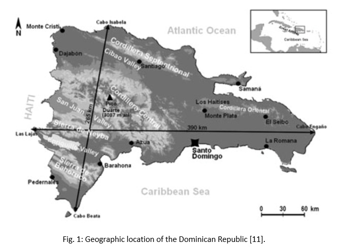
Dominican Republic has a tropical climate, with a high climatic variety, presenting a range of rainfall ranging from 700 to 2400 mm per year and temperatures around 25ºC and 30ºC depending on the region of the country.1 Thus, the geographical distribution of water availability puts at risk some populations (for example: Montecristi, Dajabón, San Juan and Elías Piña) with respect to their present and future demand due to the effects of droughts, currently generating conflicts of use, storage and strong pressure on water resources.2,3,4 The country, is located in the Caribbean between 17°36′14” and 19°55′57” latitude north and 68°17′24” and 72°00′33” longitude west, occupying the East part of the Island of Santo Domingo (Fig. 1). It shares insular territory with the Republic of Haiti forming the second island in size of the Greater Antilles, with a total area of 48670,82 km2. It has a total population of approximately 10 million people and an average annual growth rate of 1.5%. In this context, the Dominican society has classified the drought as a threat,5,6,7 since it exposes 50% of the population7 and is one of the most frequent events in the country.8 Undoubtedly, this threat constitutes an extreme climatic affectation that society has traditionally faced as part of the natural climate variability,5,9 but whose influence and negative effects for agricultural production and environment have increased considerably due to the effect of ENSO (El Niño and the Southern Oscillation) and Climate Change in recent dekads. FAO is a user of the information generated about El Niño by organizations specialized in monitoring this phenomenon such as: OMM, CIIFEN, NOAA, IRI, among others. Therefore, FAO, through its many specialized units, monitors the evolution of this type of phenomenon and provides early indications and warnings about the possible impacts on agriculture and food security.10
|
|
Figure 1: Geographic location of the |
In this regard, FAO developed the "Drought Resilience Project", which was a cooperation program financed by the European Civil Protection and Humanitarian Aid Operations (ECHO), under the modality of a consortium with the World Food Programme (WFP), Oxfam Intermon and Plan International, together with the government of the Dominican Republic and through the National Commission of Emergencies, Ministry of Agriculture and Ministry of Environment and Natural Resources. This paper has been developed within the framework of this project11 with the aim of "Knowing the current situation of the drought in the Dominican territory, from the point of view of the meteorological, agricultural and hydrological drought; as well as the socio-economic impacts of the drought, its development, its consequences, the return to normal rainfall, food security and the measures that public institutions have taken in favor of the resilience of this hydrological phenomenon". This objective was achieved through an analysis of the existing information and the creation of a Digital Library (including scientific articles, technical reports, books, studies and press releases) that will facilitate the future work to continue understanding the drought in the country. In addition, interviews were conducted with different local actors and data and information were collected from different institutions, such as: ONAMET (agroclimatic soil moisture and precipitation deviation bulletins), FAO (ASI, AQUASTAT and studies associates), INDRHI (hydrological statistics, books and technical reports), Ministry of the Environment (atlases and technical reports), Ministry of Agriculture, CEPAL, INAPA, of the existing information and the creation of a Digital Library (including scientific articles, technical reports, books, studies and press releases) that will facilitate the future work to continue understanding the drought in the country. In addition, interviews were conducted with different local actors and data and information were collected from different institutions, such as: ONAMET (agroclimatic soil moisture and precipitation deviation bulletins), FAO (ASI, AQUASTAT and studies associates), INDRHI (hydrological statistics, books and technical reports), Ministry of the Environment (atlases and technical reports), Ministry of Agriculture, CEPAL, INAPA, among others. This will allow, the creation of capacities and the taking of opportune decisions in the matter of drought risk management.
Methodology
The Research was Carried Out Through the Development of the Following Activities:
Creation of a Digital Library
A digital library was created, which contains the compilation and review of more than 100 documents (including scientific articles, technical reports, books and studies) related to the Drought in the Dominican Republic, of which more than 50 were selected that were classified according to the theme: meteorological drought, hydrological drought, agricultural drought, socioeconomic impact of drought, climate change, water availability and others. In addition, it integrates the review of more than 25 press releases (news) that deal with the issue of drought in different parts of the country. This library aims to facilitate the realization of future work on the management of the risk of drought in the country.
Analysis of Hydrological Data Online from INDRHI (National Institute of Hydraulic Resources)
90 hydrometric and 70 meteorological stations have been analyzed with a registration period from 1966 to 2017. The detailed information of each station includes: name of the station, record, coordinates and operability. This analysis has also contemplated the information provided by other studies.4,8,13,14,15
Analysis of Hydrometeorology and Agrometeorology Data from ONAMET (National Meteorology Office)
A data systematization was done, which was provided by the institution that include information on its meteorological stations; reports and bulletins of agroclimate, soil moisture index and precipitation deviation.
Analysis of Additional Data
Agricultural Stress Index (ASI) was analyzed, which is an FAO indicator that highlights anomalies in vegetation growth and potential droughts in crop areas during a particular agricultural season.
All previous activities were accompanied by interviews with the main actors of the water resource and feedback workshops.
Conceptual Framework
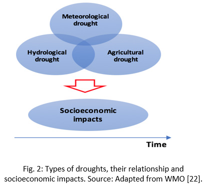
Given that there is currently no generalized definition of "drought" that covers the different categories dealt in this paper (meteorological, agricultural and hydrological drought), a drought conceptual framework was necessary to established. Some authors6,13,16,17,18 have defined the "drought" as a period considered abnormally dry or prolonged of shortage of rain, where the availability of This resource is not enough to satisfy the water demands of the different users in a specific region and, therefore, generates negative socioeconomic and environmental impacts. Given that drought is one of the most damaging meteorological events14 and it could affects more people in the world,19 it is important to characterize it according to the context to be studied. Therefore, for the present study, the analysis of the drought has been divided into: meteorological, hydrological and agricultural drought (Fig. 2).
The Meteorological or Climatological Drought
Is the prolonged absence of precipitation.20 This drought occurs when rainfall is lower than expected in an area for a specific period of time18,39. According to INDRHI.13 meteorological drought is characterized by a marked deficit of rainfall distribution in relation to that considered normal. These droughts can give rise to other types of droughts (agricultural and hydrological).
The Agricultural, Agronomic or Edaphic Drought
Can be defined as the marked and permanent precipitation deficit that significantly reduces agricultural production in relation to the expected values for a specific region.13,18 According to INSMET and ONAMET,21 drought does not start when the rain stops, but when the roots of the plants cannot get more moisture from the soil. Therefore, agricultural drought will occur when the amount of precipitation and its distribution, as well as the water reserves in the soil and evapotranspiration losses, combine to cause considerable declines in crop and livestock yields. This has consequences: depressed food production, inadequate grazing conditions, low profitability of agricultural jobs and investments, low availability of wood for combustion, greater danger of occurrence of fires in vegetation, greater risk of desertification and insecurity in supplies food.
Hydrological Drought
Or water deficit is an abnormally dry period of time, long enough to cause a shortage of water, which is reflected in a significant decrease in the flow of rivers and in the level of lakes and/or depletion of soil moisture and the descent of groundwater levels below their normal values.20 It’s possible to speak of hydrological drought when there is a regional rainfall total less than the seasonal average (meteorological drought), which translates into a level of abnormal supply of water channels and reservoirs superficial and underground.13
|
|
Figure 2: Types of droughts, their relationship and socioeconomic impacts. Source: Adapted from WMO22 |
Results and Discussion
Overview and Historical Drought
According to FAO,23 the Oceanic Niño Index (ONI) has become the standard that the National Oceanic and Atmospheric Administration (NOAA) uses to identify episodes of El Niño (hot phase) and La Niña (cold phase) in the Tropical Pacific (Fig. 3). El Niño corresponds to a local warming of the surface waters that occurs throughout the equatorial zone of the Pacific Ocean, both central and eastern of the Peruvian coast and affecting the atmospheric circulation throughout the world, reaching its maximum intensity in the month December,23,24 In contrast, La Niña refers to the cold phase of the event and is a recurrent meteorological phenomenon that takes place between two or seven years and normally lasts between 12 and 18 months.23,25
|
|
Figure 3: Oceanic Niño Index (ONI)26 |
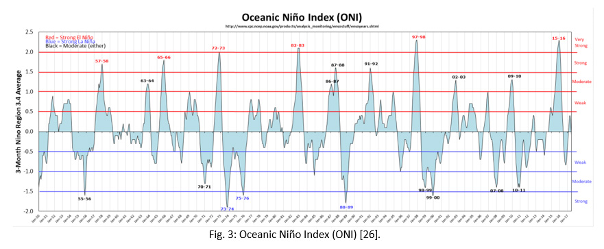
Thus, in Central America, El Niño could intensify the effect of the phenomenon known as “canícula”, a reduction in rainfall during July-August, which mainly affects the campaign of the first harvest (First) and the second (Postrera) [23], while La Niña generates excess rainfall.8 In fact, in recent years the effects of the drought have been exacerbated by the reduction of rainfall and the increase in temperatures associated with ENSO.9
As shown in Fig. 4, any phase (neutral, hot or cold) could be associated with droughts in the agricultural areas of the planet. It is interesting to note that cycles dominated by El Niño have been associated with a greater area affected by drought at the level of world agriculture, regardless of whether there are neutral years or cold events in the middle of this cycle.23 Likewise, in the map of the standardized precipitation index (SPI) of the cited Fig. 4, it is shown that during the years 2009 and 2010, although they were under the La Niña domain, there were also affectations in the agricultural surfaces (of the Caribbean countries, mainly) product of the agricultural and hydrological drough.8,10
|
|
Figure 4: Relationship between the agricultural area affected by drought (ASI) and the episodes of El Niño in the tropical Pacific of the last 30 years forthe first and second agricultural seasons. The bars represent the agricultural area affected by the drought, in percentage10,23 |

In the Dominican Republic there is a wide network of meteorological and hydrometric stations operated by ONAMET and INDRHI, which have allowed us to follow more closely the phenomenon of drought and El Niño events. Although there have been drought events since 1914 to date, special mention should be made of the events recorded in 1938, 1939, 1941, 1944, 1947, 1957, 1959, 1967, 1975, 1977,13,272009, 2010, 2011 and 2015.
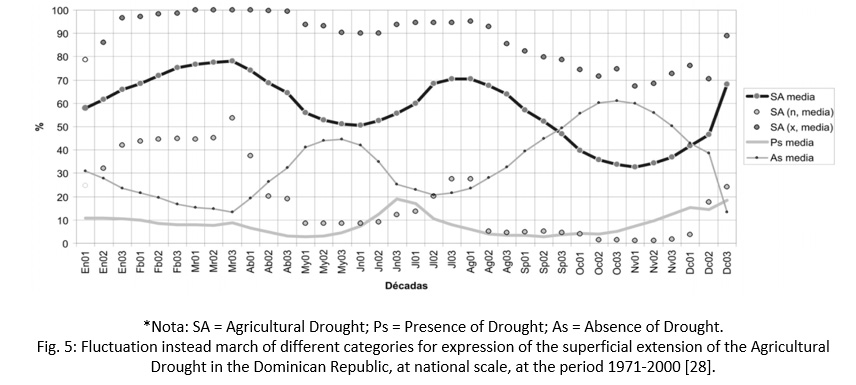
Cardona15 recorded a total of 160 drought events over the 35 years analyzed (1966-2000), where nearly 100% appear to be associated with low rainfall. The biggest events have been registered in the northwest part of the country (Santiago, Valverde, Puerto Plata, and Monte Cristi) and to the south in the National District. Likewise, Vásquez and others [28] determined that the manifestation of the Agricultural Drought coincides with the seasonal climate periods, observing two maximums and two minimums (Fig. 5). The absolute maximum occurs in the third dekad of March and the first of April (78%), the second relative maximum is registered in the first dekad of August (71%); while the absolute minimum is observed in the second dekaed of November (33%) and the relative minimum occurs in the first and second dekad of June (51%).
|
|
Figure 5: Fluctuation instead march of different categories for expression of the superficial extension of the Agricultural Drought in the Dominican Republic, at national scale, at the period 1971-200028 |
Although the impact of the drought on the populations and the agricultural production is increasing, it lacks the required resources and the comparative information that allows to quantify the phenomenon.13 This statement was made evident in the study developed by BIRF and BID,8 where 70 INDRHI meteorological stations with different data length and quality were analyzed from 1968 to 2005, the results of which showed that gaps in the information, particularly the In the mid-1990s and the beginning of the 2000s, reliable comparisons between the stations and the ENSO index were not made throughout their series, nor did they allow quantifying regional differences in the Dominican Republic. Therefore, more studies and scientific research are required (based on fieldwork, compilation of updated and continuous data in the field for a prolonged period on water quantity and quality, monitoring of hydrometric variables, among others), related to the drought in the country.
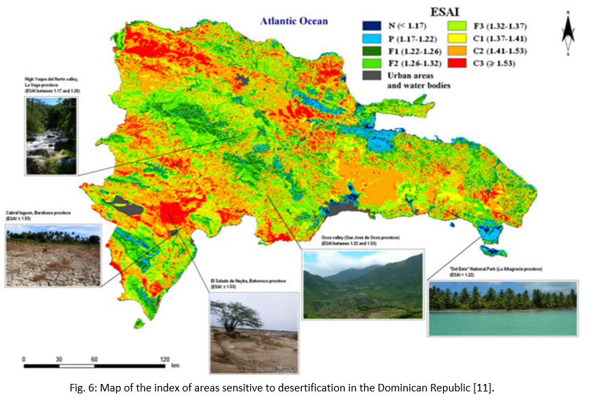
As shown in the "Aridity Map or Drought Threat Map" of Fig. 6, it is estimated that 69.6% (33401 km2) of the Dominican Republic corresponds to arid, semi-arid and dry sub-humid areas and that they are partially or totally affected by desertification and drought. This information is consistent with the index map of environmentally sensitive areas generated by Izzo and others,11 who point out that 48% of Dominican territory is critically sensitive to desertification and that 16% is in a highly critical state (Fig. 6). These areas do not have humid climates and are concentrated especially at the bottom of the valleys and in areas with low elevation (altitude less than 500 meters above sea level).
According to some authors,9,29,30 the arid zones are located in the northwestern corner of the country, between Mao and Montecristi, covering the entire Hoya de Enriquillo and extending to the outskirts of Bani. the coast of the Caribbean Sea. The semi-arid zones are located in the southwestern region, covering a strip of the extreme northwest of the country. Thus, dry sub-humid areas are located mostly in the North and Central Cordilleras, predominating in the Central Cibao Valley and the Southeast coastal plain.
|
|
Figure 6: Map of the index of areas sensitive to desertification in the Dominican Republic11 |
Socioeconomic Impacts of Droughts
According to FAO23 and CRS35, the drought has a direct economic impact by reducing or eliminating agricultural production, affecting the prices, trade and market access and decreasing income and agricultural employment.
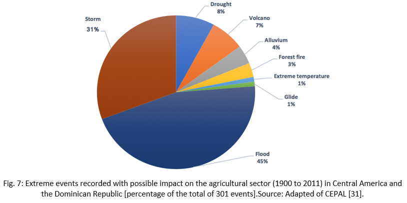
Thus, if the drought goes from being a threat to a disaster (for example, drought of 2009-2010), it creates poverty traps that increase the prevalence of food insecurity and malnutrition. According to INDRHI13, there are factors or impacts of the drought on the population that complicate the situation even more, for example: a) the reduction of the availability of fresh water for the domestic supply that affects a greater number of people; b) desertification is interfering with efforts to combat poverty and social marginality; c) the lack of awareness, the lack of knowledge of conservative techniques for agricultural production and the lack of resources to face the problem. According to CEPAL,31 using the International Disaster Database (EM-DAT), of the 565 extreme events recorded in the last 111 years in Central America and the Dominican Republic, 357 have affected the agricultural sector directly. Of these 357 events, the highest records are (Fig. 7): floods (46%), storms (31%) and droughts (8%); followed by volcanoes, landslides and landslides that represent 12% as a whole, while the rest corresponds to forest fires (3%) and extreme temperatures (1%) that can be associated with meteorological drought.
|
|
Figure 7: Extreme events recorded with possible impact on the agricultural sector (1900 to 2011) in Central America and the Dominican Republic [percentage of the total of 301 events]. |
According to OXFAM5 the social impact of the drought in the Dominican Republic has been seen in the impact of the livelihoods area of the population's basic crops (banana, rice, cassava, etc.) and in the sources of food and income (food and economic security of the most vulnerable households). These social impacts (described throughout the document) correspond to: changes in the production levels of the harvests, the increase in prices, changes in hiring day laborers, among others. In 2010, several agricultural regions around the country reported serious losses due to severe drought conditions. During this event, the water storage capacity of many dams decreased, negatively impacting the rice and cocoa sector. Some regions reported a 30% reduction in rice production, while production at the national level decreased between 10 and 15%.8 Likewise, in 2011 it was reported that the most affected provinces were La Vega, Santiago, Valverde, Montecristi and other towns, where hundreds of quintals of plantain, yucca and sweet potato were lost. In this sense, it is important to consider that losses due to drought are not considered as a cause of compensation, so that farmers were not compensated for the economic losses suffered.
According to the study developed by CEPAL,31 the estimated cost of damage from droughts as a "disaster" from 1900 to 2011 was 5 million dollars (US$ 5 million), equivalent to 0.17% of the total costs for disasters in the country (Table 1). This figure reached its peak with the 2009 drought, which in Central America caused losses of basic grains production and water availability for approximately 70 million dollars.
The Ministry of Agriculture19 states that its direct effects on production can disturb the supply of water for human consumption, force populations to migrate to other cities and, in extreme cases, can cause famine and the death of people.
Table 1: Summary of damages in Dominican Republic
|
Type of disaster |
Cost (US$ million) |
Percentage |
|
Storm |
2798 |
96.42% |
|
Flood |
98.0 |
3.38% |
|
Drought |
5.0 |
0.17% |
|
Forest fire |
1.0 |
0.034% |
|
Total |
2902 |
100.0% |
Source: Adapted of CEPAL.31
Situation for the Last Four Years
A systematization of the information available for the last four years has been carried out: 2014, 2015, 2016 and 2017.
Situation period: 2014-2015
For this situation, the historical monthly variation of rainfall in the Dominican Republic has been considered, which presents two rainfall regimes defined by the meteorological phenomena of translation.13
The first corresponds to the northern and eastern portions of the Northeast, say, north of the Northern and Eastern Cordilleras, presenting a rainy season in the autumn and winter climatic and dry season in spring and summer, with values higher than 600 mm in the fall and over 300 mm in the winter climatic.
The second regime corresponds to the rest of the Dominican territory, with drought in the winter climatic, less than 200 mm and with rainy season in spring and summer with values above 600 mm on the Haitises, the basins of Ozama, Isabela, Haina, Alto Yuna, Alto Nizao, Las Cuevas, Sierra de Bahoruco and western portion of the Sierra de Neyba; as well as in the basins of Yuna, Ozama, Mahomita, Alto Yaque del Norte, Guanajuma, Jagua, Bao, Mao, Guayubin, Joca, San Juan, Alto Yaque del Sur and Altibonito, towards the Central Cordillera.
Under this climatic scenario, the national production of the years 2014 and 2015 (Table 2), registered a contraction in the majority of the crops, induced by the drought event, where items such as plantain and snap bean presented variations of the order of 11.5 and 36.1%, respectively.19 On the order hand, a number of studies developed in 2014 indicate that human-caused climate change greatly increased the likelihood and intensity for extreme heat waves in this year over various regions of the world (Central-America, Singapore, East Africa, Horn of Africa, Middle East and Central-Southwest Asia and Southern Levant Region).41
According to Ministry of Agriculture,19 this percentage variation in production was related to a reduction in rainfall during 2015, since the end of 2013, rainfall was not enough in most of the localities that make up the region's agricultural and livestock Ministry of Agriculture, generating accumulated deficits that negatively impacted the soil moisture conditions and whose consequence led to a decrease in natural resources and the raw material used for agricultural production. The Ministry of Agriculture estimates that the prolonged drought in 2015 affected some 216339 plantation areas throughout the country.19
The situation of the 2015 drought was very alarming, being registered in almost all the media of the country, in fact, in the bulletins of the soil moisture index of [32] a call was made to the population to rationalize the water throughout the Dominican territory, since it was the worst water deficit of the last twenty years (Fig. 8). According to OXFAM,5 throughout the years 2014 and 2015, the drought caused the inflation of the prices of the majority of staple foods of around 7.98%, where in the case of rice and snap beans, inflation reached between 21 and 100% in several areas of the country, while the banana tripled its price. In the period January-March 2014-2015, the contribution to the Gross Domestic Product (GDP) of the agricultural sector was reduced from 10.8% (2014) to 5.8% (2015) approximately (which increased the credit or "indebtedness" to the agricultural production in 14.6%, that is, around US$129 million, according to reports from the Central Bank of the Dominican Republic.1
This climatic scenario that was presented in the period 2014-2015, is consistent with the water balance projected by the INDRHI Hydrological Plan (2012) for 2015,13 where most of the basins registered a strong pressure on the country's water resources (Table 3), particularly the Yaque del Norte (98.6%), Yaque del Sur (80.56%) and Yuna (57.66%) basins. This situation could have been counteracted by measures such as: a) modernization of the irrigation infrastructure, b) action plans in the short, medium and long term on water security and drought, c) improvement in the efficiency of drinking water supply networks, d) strengthening of educational programs aimed at the population and communities to promote a culture of rationality in the use of water and the conservation of water resources and watersheds.
Table 2: Percentage Variation of Agricultural Production at National Level 2014 vs. 2015 [Values Expressed in Quintals, Thousands and Bunches]
|
Products |
Total Production |
Total Production |
Variation |
|
Corn |
793,075.00 |
750,799.00 |
-5.33 |
|
Peanut |
117,004.00 |
112,167.00 |
-4.13 |
|
Bean R. |
475,600.00 |
369,870.00 |
-22.23 |
|
Bean N. |
336,331.00 |
215,232.00 |
-36.01 |
|
Bean B. |
11,398.00 |
8,986.00 |
-21.16 |
|
Guandul |
542,854.00 |
461,817.00 |
-14.93 |
|
Sweet potato |
988,045.00 |
910,732.00 |
-7.82 |
|
Yucca |
3,932,393.00 |
3,514,296.00 |
-10.63 |
|
Auyama |
854,044.00 |
762,139.00 |
-10.76 |
|
Eggplant |
489,498.00 |
462,307.00 |
-5.55 |
|
Onion |
1,338,160.00 |
1,269,203.00 |
-5.15 |
|
Cucumber |
278,503.00 |
275,195.00 |
-1.19 |
|
Cabbage |
26,661.00 |
25,297.86 |
-5.11 |
|
Tayota |
263,611.00 |
179,421.13 |
-31.94 |
|
Orange D. |
738,156.00 |
660,851.60 |
-10.47 |
|
Pineapple |
192,375.00 |
180,404.66 |
-6.22 |
|
Grapefruit |
32,059.00 |
24,186.75 |
-24.56 |
|
Banana |
2,467,341.00 |
2,193,179.44 |
-11.11 |
|
Total |
13,877,108.00 |
12,376,084.44 |
-10.8% |
Source: Adapted of Ministry of Agriculture.19
|
|
Figure 8: Percentage of agricultural area affected by drought for the period 1984-2016) in the Dominican Republic12 |
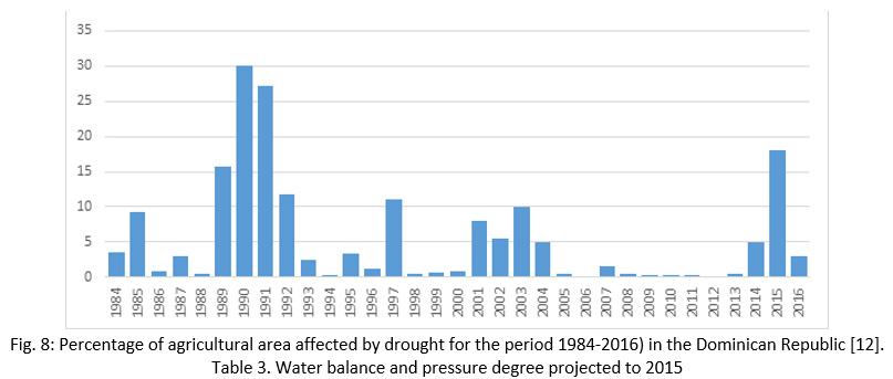
Table 3: Water Balance and Pressure Degree Projected to 2015
|
Hydrographic Region |
Water availability |
Uses or demand for water |
Water pressure |
Water pressure |
|
Yaque del Norte |
3,086.46 |
3,043.34 |
98.60% |
Strong |
|
Atlántica |
4,850.73 |
694.39 |
14.32% |
Moderate |
|
Yuna |
3,836.96 |
2,212.37 |
57.66% |
Strong |
|
Este |
3,883.95 |
764.11 |
19.67% |
Half |
|
Ozama-Nizao |
4,916.08 |
1,718.51 |
34.96% |
Half |
|
Yaque del Sur |
5,392.51 |
4,344.37 |
80.56% |
Strong |
|
Total |
25,966.69 |
12,777.09 |
51.0% |
|
Source: Adapted of INDRHI.13
Situation Period: 2016-2017
For the year 2016 and 2017 there is very little information available regarding the hydrological drought. The hydrological statistics (flows) provided by the INDRHI deserves to be updated, since of the 90 hydrometric stations analyzed, only 6 stations have information until 2000-2004 (Manabao, El Limón, Bocaina, Los Guiros, Pinar Quema and Santa Lucía) and the majority only until 1995. The rest is maintained between the 60s and 80s. That is why, currently the INDRHI (as the body responsible for hydrological monitoring) is working on updating its hydrometric records through a new platform that will soon be launched. to the public with free and free access to download the data. Regarding the meteorological and agricultural drought, ONAMET has maintained a continuous monitoring of both phenomena through its monthly and quarterly bulletins of soil moisture index and agroclimate reports.
As can be seen in Fig. 9, the monthly average of rainfall increased considerably with respect to the previous situation (2014-2015), although in some localities of the country such as San Juan, Dajabón and Montecristi,32 the amount was well below normal rains; generating moisture deficits in the soil. For this reason, ONAMET recommended during this year to make an adequate use of water and to monitor the crops in the localities where the soil moisture was very deficient.
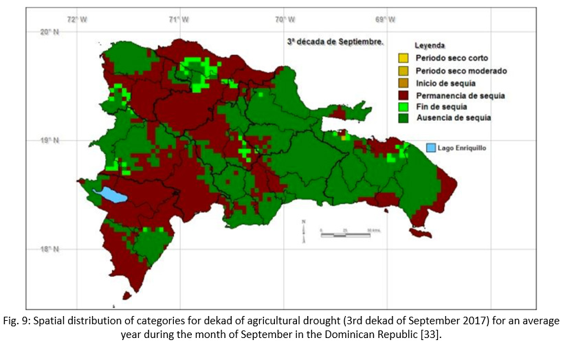
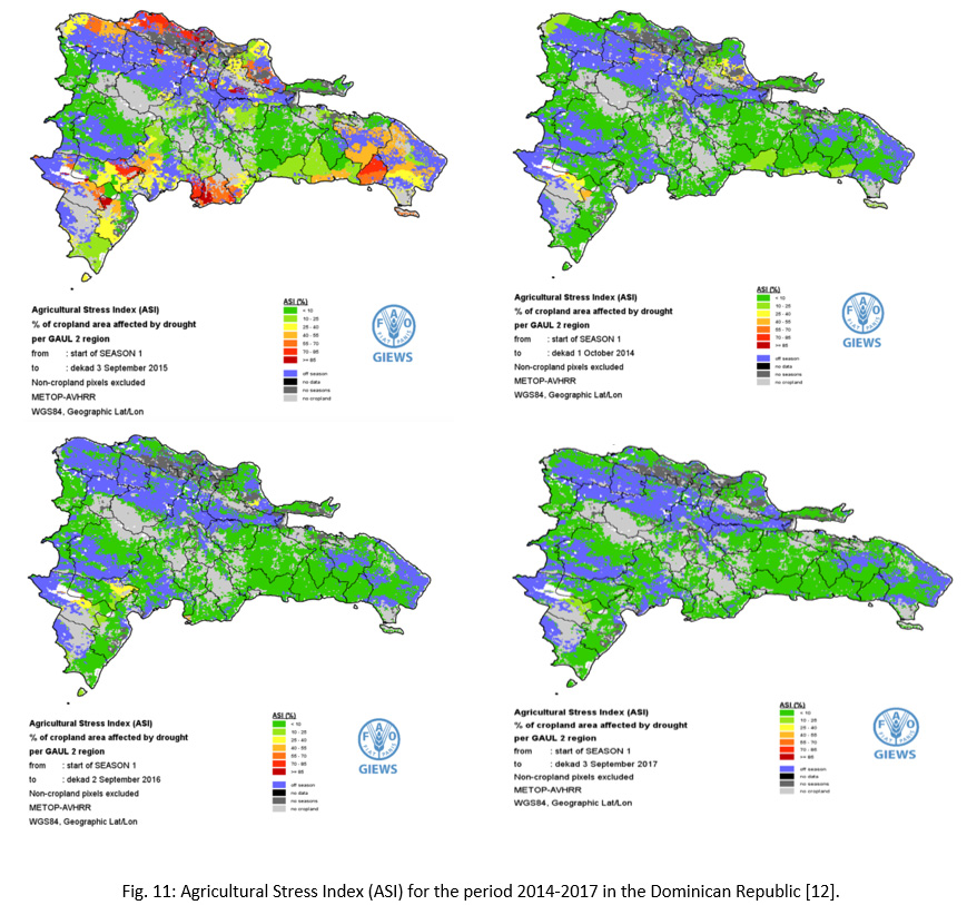
According to OXFAM,5 in the second agricultural campaign (October-November), the majority of farmers (around 70% of the area) lost almost the entire harvest (between 95% and 100% of production). For 2017 the situation is less worrisome, since rains have been present throughout the national territory and this has favored the reduction of the regional drought that hit the country hard during 2015. In addition, this year the institutions of the CNE have been carrying out a more exhaustive monitoring of the phenomenon, mainly ONAMET (Fig. 9 and 10) and other international institutions such as FAO (Fig. 11), which issue products and bulletins every 10 days (dekad).
In Fig. 9, 10 and 11 it can be seen that, for the month of September 2017, although there are areas of the country with no drought (for example, Monción that presented an excess of humidity in the ground of 98 mm), there is still a permanence of the drought in the Northwest region, with deficiency values ranging from 141.1 mm in Montecristi and 5 mm in Dajabón.
|
|
Figure 9: Spatial distribution of categories for dekad of agricultural drought (3rd dekadof September 2017) for an average year during the month of September in the Dominican Republic33 |
|
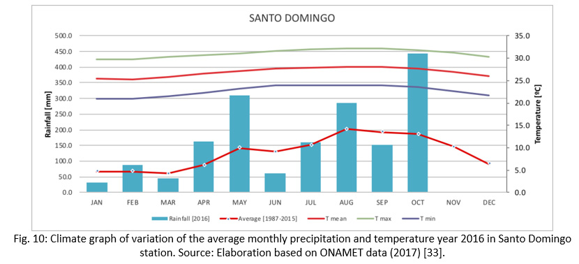
|
Figure 10: Climate graph of variation of the average monthly precipitation and temperature year 2016 in Santo Domingo station. Source: Elaboration based on ONAMET data (2017)33 |
|
|
Figure 11: Agricultural Stress Index (ASI) for the period 2014-2017 in the Dominican Republic12 |
Investment Projects Related to Drought
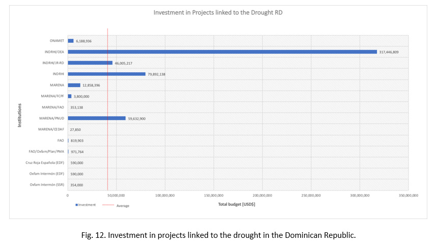
In the last four years, the country has developed some research and projects linked directly or indirectly to the drought phenomenon (meteorological, agricultural and hydrological). Table 4 shows the projects identified, in which the responsible institution is indicated, the name of the project, the scope and / or products, the execution period, the beneficiaries and the total budget of the project. Also, Fig. 12 shows the estimated investment in projects that have a certain degree of linkage with the reduction of the effect of drought in the country, which reached USD$ 529.5 million and where the largest budgetary amounts fall low responsibility of INDRHI (USD$ 443.3 million), MARENA (USD$ 76.7 million) and ONAMET (USD$ 6.19 million). In addition to the previous projects, plans, programs and strategies linked to drought and disaster risk management have been developed, of which they deserve mention.6,7,34
National Plan Quisqueya Verde
National Program 21 and National Climate Change Program
National Strategy and Action Plan for the Conservation of Biodiversity
Small Grants Program of the Global Environment Facility (PPS / GEF)
National Plan for Social Development
National Plan for the Reduction of Poverty Dignified Community Program
National Plan of Food and Nutrition (PLANAN)
National Strategy of Environmental Education
National System of PMR before disasters
National Risk Management Plan
National Comprehensive Disaster Risk Management Plan
National Emergency Plan
Integrated National Information System
National Fund for Prevention, Mitigation and Response to Disasters
National Hydrological Plan
Water Quality Improvement Plan
Plan to Improve Irrigation Management and Sub-Plan to Reduce Drinking Water Deficit
Global Framework of Action for Climate Change (FAO).
Programa de Acción Nacional de Lucha Contra la Desertificación (PAN-LCD).36,37,38
Programa de Acción Nacional Fronterizo (PAN-FRO).40
|
|
Figure 12: Investment in projects linked to the drought in the Dominican Republic |
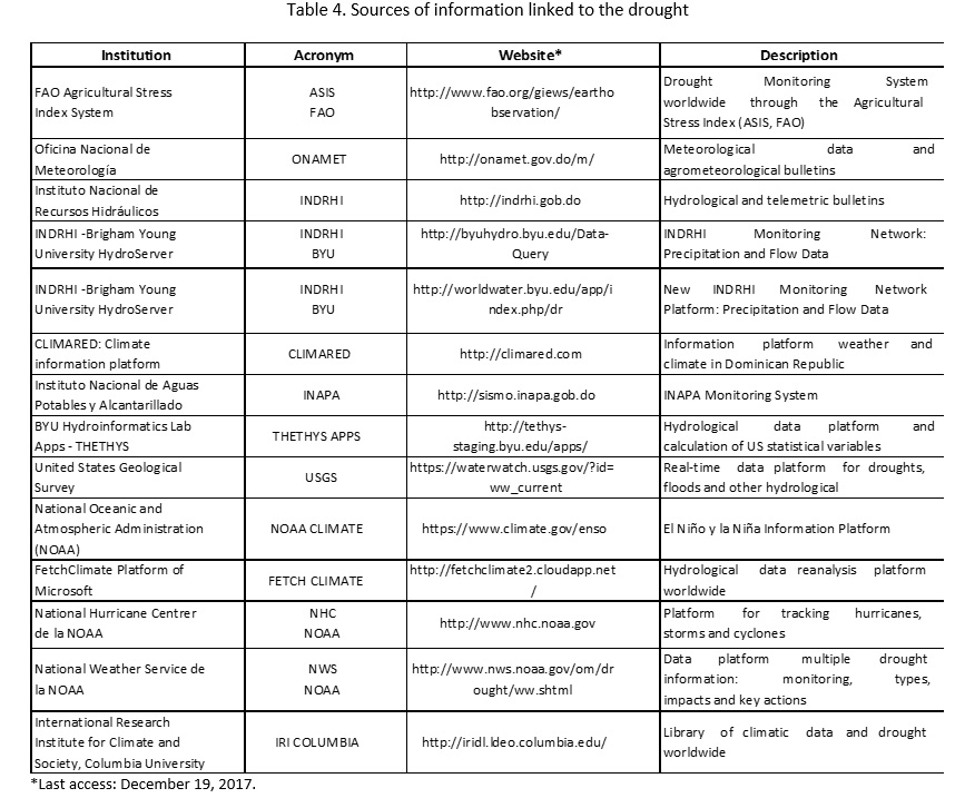
Sources of Information Related to Drought
In addition to the investment projects and plans developed by various institutions to address the issue of drought in the Dominican Republic, there is a large amount of digital information that can be consulted freely by stakeholders, users and decision makers regarding the phenomenon studied. Table 4 presents a summary (by institution) of these sources, as a way of informing the community of websites or virtual platforms that are not always available through traditional search engines.
|
|
Table 4: Sources of information linked |
Conclusions
The drought is an adverse hydrometeorological event that occurs slowly and whose negative socioeconomic impacts on water resources, agriculture and livestock have generated havoc in the Dominican population for dekads. According to the analysis made, the impacts of the drought have intensified in the last 4 years as a result of climate change, putting at risk agricultural and livestock production, as well as food security in several areas of the country, mainly those with less availability of food. water: Montecristi, Dababón, Elías Piña and San Juan.
The resurgence of the situation in recent years has prompted a series of public policies and actions by national and international institutions. There is evidence of the investment made in projects linked to drought that seek to investigate the phenomenon and offer solutions to current problems. In addition, a series of digital sources and tools have been made available to the community and decision makers to keep the population informed about the problem. However, in the development of the study, a series of shortcomings and aspects to be improved have been detected that must be considered if the future of the water resource is to be successfully confronted and thus mitigate its impacts in the country.
Among these shortcomings and possibilities for improvement, are the series of difficulties presented in the process of collecting data, information and projects related to drought: slow data transfer and delayed response by some institutions; reception of outdated and discontinuous information; omission of emails and written requests by some key actors during the process; lack of information flow between public and local institutions; suspension of activities resulting from extreme events such as hurricanes and tropical storms.
To the above, it is added that, at present, very few studies and scientific investigations have been identified (based on empirical research, fieldwork, compilation of updated and continuous data in the field for a prolonged period on quantity and quality of water, monitoring of hydrometric variables, among others), related to the drought in the country, that allow to offer mechanisms to understand the phenomenon in its different dimensions (meteorological, hydrological and agricultural) and how to prevent, mitigate and respond to the effects that this phenomenon may cause. The realization of new technical-scientific studies can offer key information to build an information base for the generation of public policies and decision making.
On the other hand, there is a lack of information about the hydrological drought. No analysis or interpretations of "rainfall-flow" data or "historical series of flows and levels" of the hydrometric stations have been identified that allow visualizing the effects of droughts on the bodies of surface and groundwater of the Dominican territory. A large information gap has been identified in the hydrological data of the hydrometric stations, which is due to the lack of human resources for the continuity of the collection of information, as well as the lack of economic and political resources to replace or repair the stations that have been damaged by the floods of the rivers and the vandalism. It has also been detected that although there is a legal framework for prevention, mitigation and response (PRM) in the country focused on disaster risk management (tropical storms, cyclones, floods, etc.), there are currently no public policies aimed at drought management and the implementation of an early warning system for this phenomenon.
In spite of the above, it should be noted that within the framework of the Drought Resilience Project, the Petit Drought Committee was created consisting of: INDRHI, ONAMET, IAD, INAPA, MARENA, Ministry of Agriculture and INTEC. This initiative is fundamental in the context of the difficulties encountered, since it promotes dialogue and the transfer of information among the various national institutions, as well as the development of actions to address the problem of drought, such as: the creation of a system Early warning and drought risk management in the Dominican Republic with a resilient and synergistic approach between these institutions and the community in general.
Recommendations and Research Perspectives
To face the drought in the Dominican Republic, several institutions agree to formulate plans and public policies (national, municipal and local), in addition to legal frameworks adjusted to the current situation; protect natural water systems (rivers, lakes, lagoons, aquifers) and other water sources; reforest the riverbanks; protect agricultural lands and natural parks; make changes in technology and irrigation efficiency; increase the capacity of regulation or volume stored by reservoirs or dams, among others. In addition, it is necessary to join efforts between the main meteorological data generating institutions (INDRHI and ONAMET, mainly), in order to achieve a system that allows them to monitor drought (prediction, mitigation and response) at the country level, without any need to duplicate their efforts.
In this sense, to prevent the effects of hydrological drought: it is recommended to carry out a "Critical Analysis of the entire Monitoring Network of the country and propose an Optimized Monitoring Network for Drought", with the objective of improving said network and obtaining data. more reliable, representative and timely in the prediction of extreme events. This analysis should include: type of station, measured variables, operability, quantity, density, measurement technology and data transmission, geographical location of the stations, among other data that allow to characterize and optimize the existing monitoring network according to the standards of the World Meteorological Organization (WMO). In addition, it is recommended to perform an updated Water Balance of the different basins of the country, which allows: a) characterizing the climatic variables (precipitation, runoff, evapotranspiration, humidity index, aquifer recharge, etc.) in the historical and current context, b) determine water availability and demand, c) model current and future scenarios (short, medium and long term) of water resources considering climate change and food security. In this balance it is important to include a "Critical analysis of the country's hydraulic infrastructures": Storage and regulation works (mainly, the Large and Small Dams); Drinking water (aqueducts, treatment plants for drinking water and wastewater) and irrigation, drainage and pumping systems. It’s recommended to explore new water sources or "water alternatives" in those areas with the greatest threats to the drought phenomenon. Among those alternatives can be counted: exploration of groundwater; wastewater treatment (green filters, facultative ponds, etc.) for agricultural purposes; transfer of basins; Desalination of brackish and salty waters.
Likewise, to prevent the effects of the meteorological drought: it is recommended to design and/or implement an Early Warning System for Drought (SATS) that integrates the information of the "automatic" stations: meteorological (precipitation and temperature), hydrometric (flows of rivers and levels of reservoirs) and piezometric (levels of aquifers or groundwater), in which thresholds are established to predict meteorological events of drought in a timely manner. This system should at least integrate the historical and updated data in real time of the network of stations, as well as the data of El Niño phenomenon and its spatio-temporal variability at the level of the river basin.
Regarding the agricultural drought, it is suggested to take into account the FAO Global Framework for Action that seeks to address water scarcity in agriculture, which promotes and supports alliances to share the knowledge and experience of interested parties and allow actions aimed at the sustainable use of water and, therefore, address the challenges of agricultural production and livelihoods due to climate change.
In addition, it is recommended to implement the ASIS-Country tool in the Dominican Republic that would give more precise results than the global results published on the FAO/GIEWS website.
Acknowledgments
Drought Resilience Project (OSRO/DOM/601/EC) funded by the European Civil Protection and Humanitarian Aid Operations (ECHO) and executed by the FAO, WFP, Oxfam Intermon and Plan International Consortium. Also, autors thank the institutions of the “Petit Committee”, especially ONAMET, INDRHI, INTEC, MARENA, PMA, INAPA, IAD and MA, who provided data of first source to make possible the investigation. Finally, authors thank reviewers for their appreciation and helpful comments.
References
- Food and Agriculture Organization of the United Nations – FAO (2011). Summary Fact Sheet: Dominican Republic. AQUASTAT 2011. Available in: http://www.fao.org/nr/water/aquastat/data/wbsheets/aquastat_water_balance_sheet_dom _es.pdf [Last access. 2017.
- Ministerio de Medio Ambiente y Recursos Naturales (MARENA), PNUMA, UASD y CEDAF (2010). Informe GEO República Dominicana: Estado y Perspectivas del Medio Ambiente. 2010.
- Medrano, O.R. y Payano Almánzar, R. Agua, Energía y Seguridad Energética en la República Dominicana. Artículo publicado en la Revista Latinoamericana de Energía (ENERLAC- OLADE), Quito-Ecuador. 2012.
- Instituto Nacional de Recursos Hidráulicos (INDRHI). “Estadísticas del Agua en la República Dominicana”. Libro I, Publicaciones del INDRHI. 2006.
- OXFAM. Con la Seca al cuello: EvaluacioÌn del impacto de la sequiÌa en la zona de medios de vida de cultivo del plaÌtano, provincia de Bahoruco y en la zona de medios de vida de cultivo del arroz, provincia de Montecristi, usando la metodologiÌa HEA. DireccioÌn General de Ayuda Humanitaria y ProteccioÌn Civil de la ComisioÌn Europea (ECHO). 2016;70.
- Documento País República Dominicana (DP RD). Análisis de riesgos de desastres y vulnerabilidades en la República Dominicana. Documento de contribución al Sistema Nacional de Prevención, Mitigación y Respuesta a Desastres. Elaborado por: Gómez N. y P. Sáenz Ramírez. VI Plan de Acción DIPECHO para El Caribe. 2009;111.
- Documento País República Dominicana (DP RD). Revisión, actualización y análisis de amenazas y riesgos ante desastres en República Dominicana. Documento de contribución al sistema nacional de prevención, mitigación y respuesta a desastres versión 2010-2011. Elaborado por: Meyreles L. y Ruíz V.E. Dirección General de Ayuda Humanitaria y Protección Civil (DG-ECHO). 2010;135.
- Banco Internacional de ReconstruccioÌn y Fomento-BIRF & Banco Mundial-BID. Estudio de factibilidad de seguro agrícola por índices informe de avance: seguro de índices a nivel macro. 2013;100.
- Herrera, A. & Orrego, J.C. RevisioÌn del estado de la situacioÌn de riesgo climaÌtico y su gestioÌn en RepuÌblica Dominicana. [IISD Report]. Santo Domingo: Instituto Internacional para el Desarrollo Sostenible y Naciones Unidas. 2011.
- Food and Agriculture Organization of the United Nations –FAO. Drought characteristics and management in the Caribbean. Land and Water Division and Robert B. Daugherty Water for Food Institute, Rome. 2016.
- Izzo M., N. Araujo, P.P.C. Aucelli, A. Maratea & A. Sánchez. Land sensitivity to desertification in the Dominican Republic: an adaptation of the ESA methodology. Land Degrad. Develop. 2013;24:486–498.
- Food and Agriculture Organization of the United Nations - FAO. http://www.fao.org/home/en/. 2017.
- Instituto Nacional de Recursos Hidráulicos (INDRHI). “Plan Hidrológico Nacional”. Editora Alfa y Omega, República Dominicana. 2012.
- Centella A., B. Lapinel, O. Solano, R. Vázquez, C. Fonseca, V. Cutié, R. Baéz, S. González, J. Sille, P. Rosario & L. Duarte. La sequía meteorológica y agrícola en la República de Cuba y la República Dominicana, Proyecto PNUD/ACDI Desarrollo y Adaptación al Cambio Climático. 2007;172.
- Cardona O.D. Los desastres ocurridos en la República Dominicana 1966-2000. Secretaria Técnica la Presidencia y Banco Interamericano de Desarrollo. 2001;55.
- United Nations – UN. Convención de Lucha contra la Desertificación (CDD), Parte 1, Introducción, Artículo 1 (DPCSD/CCD/95/2). 1996.
- Brown O., Y. Gallardo-Ballat, MT. Cuffy & W. Pérez- Duarte W. Sistema de gestión de sequías, una alternativa para la utilización racional de los recursos hídricos en empresas agrícolas. Rev. Cienc. Téc. Agropec. 2009;18(2):47-52.
- Gallardo Y. Sistema de Gestión de Sequía para la mitigación y adaptación de los impactos negativos en áreas agrícolas del municipio Venezuela de la provincia Ciego de Ávila, Múnich, GRIN Verlag, http://www.grin.com/es/e-book/312093/sistema-de-gestion-de-sequia-para-la-mitigacion-y-adaptacion-de-los-impactos. 2015.
- Ministerio de Agricultura de República Dominicana - Ministry of Agriculture. Plan de Sequía del Sector Agropecuario. Informe Borrador. En edición. 2017.
- World Meteorological Organization – WMO and United Nations Educational, Scientific and Cultural Organization-UNESCO. International Glossary of Hydrology. WMO Nº. 2012;385:461.
- Instituto de Meteorología de la República de Cuba-INSMET & Oficina Nacional de Meteorología de la República Dominicana-ONAMET. Estudio de la climatología de la sequía agrícola en la República Dominicana. 2005;62.
- World Meteorological Organization – WMO. Programa Integrado de Gestión de Sequías: Monitorización de sequías e Índices de Sequías. Disponible en: https://www.slideshare.net/GWP-Sudamerica/taller-sequa-tucumn-2016-omm-sequias [último acceso: 16 de octubre de 2017. 2016.
- Food and Agriculture Organization of the United Nations - FAO. Entendiendo el impacto de sequiÌa provocada por El Niño en el aÌrea agriÌcola mundial: una evaluacioÌn utilizando el IÌndice de EstreÌs AgriÌcola de la FAO (ASI). Produced by: Oscar Rojas, N.R.C., Yanyun Li, E.S.T & Renato Cumani, N.R.L. 2015.
- Kiladis G. & Diaz H. Global climatic anomalies associated with extremes in the southern oscillation, Journal of Climate. 1989;2:1069-1090.
- Centro de Predicción del Clima-CPC. Preguntas frecuentes ENSO: ¿con qué frecuencia ocurren normalmente El Niño y la Niña? Centro Nacional de Predicción Ambiental. (ENSO FAQ: How often do El Niño and La Niña typically occur? National Centres for Environmental Prediction) http://www.cpc.ncep.noaa.gov/. 2005.
- Golden Gate Weather Service – GGWS: El Niño and La Niña Years and Intensities. http://ggweather.com/enso/oni.htm 2017.
- Cocco Quezada A. Análisis de las Sequias en la Republica Dominicana. 1992. Available in: http://www.acqweather.com/ANALISIS%20DE%20LAS%20SEQUIAS.pdf [Last access: October 12, 2017].
- Vázquez R., Solano O., Gonzáles S.Y., Duarte L. & Camacho D. Análisis de la Sequía Agrícola establecida en la Republica Dominicana desde 1971 al 2000. Climate Variability and Change—Hydrological Impacts (Proceedings of the Fifth FRIEND World Conference held at Havana, Cuba, November 2006), IAHS Publ. 2006;308.
- Ministerio de Medio Ambiente y Recursos Naturales (MARENA). Atlas de Biodiversidad y Recursos Naturales de la República Dominicana. ISBN: 978-9945-8728-4-2, Santo Domingo, República Dominicana. 2012.
- Ministerio de Medio Ambiente y Recursos Naturales-MARENA y Grupo TécnicoInterinstitucional-GTI. Programa de Acción Nacional de Lucha Contra la Desertificación y los efectos de La Sequía PAN-LCD: Alineado con la Estrategia Decenal y la Estrategia Financiera Integrada del Gobierno Dominicano en Seguimiento a la Aplicación de la Convención de Naciones Unidas de Lucha
contra la Desertificación y los Efectos de la Sequía – CNULD. Santo Domingo, República Dominicana. 2012.
- Comisión Económica para América Latina y el Caribe-CEPAL. Gestión integral de riesgos y seguros agropecuarios en Centroamérica y la República Dominicana: Situación actual y líneas de acción potenciales. Naciones Unidas. 2013;121.
- Oficina Nacional de Meteorología de la República Dominicana-ONAMET. http://onamet.gov.do/m/
- Oficina Nacional de Meteorología de la República Dominicana-ONAMET. Base de datos: Estaciones meteorológicas; Boletines de Agroclima, Índice de Humedad del Suelo y Desviación de las Precipitaciones (2012-2017). Departamento de Meteorología Operativa. División de Agrometeorología. 2017.
- Oficina Nacional de Planificación-ONAPLAN. Primer Informe Nacional de la República Dominicana sobre la implementación de la Convención de lucha contra la Desertificación y la Sequía. Oficina Nacional de Planificación, Secretariado Técnico de la Presidencia, Santo Domingo. 2000;39.
- Consorcio Resiliencia para la Sequía - CRS. Desarrollo de los Protocolos de Acción para un Sistema de Alerta para la Sequía y Respuesta Local para las provincias de Montecristi, San Juan, Elías Piña y Dajabón. 60 páginas. 2017.
- SEMARENA. Segundo Informe Nacional de la República Dominicana sobre la implementación de la Convención de lucha contra la desertificación y la sequía. Secretaria de Estado de Medio Ambiente y Recursos Naturales, Santo Domingo. 2002;28.
- SEMARENA. Tercer Informe Nacional de Lucha Contra la Desertificación y la Sequía de la República Dominicana. Secretaria de Estado de Medio Ambiente y Recursos Naturales, Santo Domingo. 2006;58.
- Ministerio de Medio Ambiente y Recursos Naturales-MARENA y Grupo TécnicoInterinstitucional-GTI. Programa de Acción Nacional de Lucha Contra la Desertificación y los efectos de La Sequía PAN-LCD: Alineado con la Estrategia Decenal y la Estrategia Financiera Integrada del Gobierno Dominicano en Seguimiento a la Aplicación de la Convención de Naciones Unidas de Lucha
contra la Desertificación y los Efectos de la Sequía – CNULD. Santo Domingo, República Dominicana. 2012.
- Lohani, A.K.; Krishan, G. and Chandniha, S.K. Hydrological Disasters Management and Risk Assessment, Current World Environment 2017;12(3):520-529.
- Programa de las Naciones Unidas para el Medio Ambiente – PNUMA. Haití – República Dominicana Desafíos ambientales en la zona fronteriza. 2013;158.
- BAMS report “Explaining Extreme Events of 2014 from a Climate Perspective” published by the Bulletin of the American Meteorological Society. 2015;96(12).


