Environmental Impact Assessment of Anthropogenic Activities and Conceptual Restoration Strategy for Kham River in Aurangabad, India.
Vedant Ramchandra Karhade1
*
 , Amol Laxman Kamble1
, Shraddha Balwant Vangujare1
, Prasanna Santosh Wadgaonkar1
, Ganesh Sonaji Gadekar1
and Jagdish Godihal2
, Amol Laxman Kamble1
, Shraddha Balwant Vangujare1
, Prasanna Santosh Wadgaonkar1
, Ganesh Sonaji Gadekar1
and Jagdish Godihal2
http://dx.doi.org/10.12944/CWE.15.3.31
Copy the following to cite this article:
Karhade V. R, Kamble A. L, Vangujare S. B, Wadgaonkar P. S, Gadekar G. S, Godihal J. Environmental Impact Assessment of Anthropogenic Activities and Conceptual Restoration Strategy for Kham River in Aurangabad, India. DOI:http://dx.doi.org/10.12944/CWE.15.3.31
Copy the following to cite this URL:
Karhade V. R, Kamble A. L, Vangujare S. B, Wadgaonkar P. S, Gadekar G. S, Godihal J. Environmental Impact Assessment of Anthropogenic Activities and Conceptual Restoration Strategy for Kham River in Aurangabad, India. Available From : https://bit.ly/38uTGcZ
Download article (pdf)
Citation Manager
Publish History

Intoduction
Rivers represent as one of the key aspect of the urban spaces 1,2 as they ones served as the foundation for defining the human settlements, yet the urbanisation has degraded their ecosystem and aesthetics, often to the level that they no longer serve to the society from which the human settlements developed 3. From historical time cities have sprung up along the rivers due to availability of water, yet urbanization had adversely affected the urban rivers by the increase in the impervious cover leading to the changed hydrograph for these rivers. 4.The adverse problems suffered by the urban rivers due urbanization and lack of modification primarily include water quality degradation, removal of riparian vegetation, low-flows and increased flood frequency and invasive species 5 along with it urban rivers also suffer from ecological damages on global level termed as "urban stream syndrome" which is characterized by the flashier hydrograph, higher concentrations of nutrients and contaminants, alterations in channel morphology, reduction in the biotic richness and increased dominance of the tolerant species 6,7. Historically, the rivers flowing from the urban spaces had an important role in social connectivity, which comprises of the longitudinal connectivity for navigation purposes, human uses of the riverfronts, vertical connectivity ensuring the use of river side trail for walking or cycling and lateral connectivity across the river 8.
The general terminology of restoration is described as enhancement of the river channels in itself is confusing. Thus, the river restoration can be more precisely termed as the 'complete structural and functional return to pre-disturbance state'. River restoration has been used to improve in stream habitat by reducing the nitrogen and sediment load from intensively farmed agricultural land in order to improve the quality of landscape and to restore eroding stream system. The economy and quality of life are used to justify restoration of the rivers for the farmers and the civic leaders, while the cost-benefit ratio of the restoration of eroding river system offer an economic motivation to the river restoration engineers 9,10,11. In many cases urban river restoration only deals with the biological, chemical and hydro morphological parameters. When the social aspects are considered they only deal with aesthetical improvement of the basin and its vicinity and acceptance of the project by the public but these restoration projects lack the monitoring procedures and social metrics 12,13.
Environmental impact assessment is the prediction of impacts due to human actions which affected the environmental factors; it includes the identification, prediction and evaluation of impacts 14. The steps involved in the process of EIA are screening, scoping, prediction and mitigation, management and monitoring, and audit. In general the methods involved in the EIA are ICID check list, Matrices, Network diagrams, Overlays, Mathematical modelling, expert advice and economic techniques 15.
Various studies on the Kham river concluded that the rapid reduction in the greenery, reducing surrounding vegetation, increasing silt and nutrient load, disposal of sewage and other waste, open defecation, agricultural runoff etc. are causes of increased nutrient quantities and organic load inputs into the Kham River. Any change in the physio-chemical climate has a direct effect on biotic ecosystems due to the fact that different species of flora and fauna show considerable differences in their responses to the changing environment. After careful observation, it was found that the disappearance and extinction of some of the flora and fauna, particularly bottom feeding animals and migratory bird fauna from the Kham river bed, is due to sudden climate change, reduced breeding potential, habitat change, commercial and recreational river bank exploitation, lack of adequate legislation and administrative lapses, lack of adequate 16. The river is no longer just carries water but also collects and transports human waste away from the city and the main pollution issue is of municipal sewage. The water quality index (WQI) of the Kham River at the selected stations reveals that the Kham River is heavily polluted due extensive discharge of untreated sewage and mixing of the industrial wastewater. The WQI of Kham River falls under bad quality of water and unsuitable for drinking and domestic purposes 17. Along with the water quality depletion the river is also subjected to illegal activities of construction, sand excavation and ground water pollution. The pollution in the river may also lead to health hazards to the residents along the vicinity of the river 18.
The present and past condition of the Kham River at various locations is shown in Figure 1. The past photographs were taken by unknown photographer in 1860s, available at Allardyce Collection: Album of views and portraits in Berar and Hyderabad19.
 |
Figure 1: Past and Present Condition of Kham River Click here to view Figure |
Objective
The main objective of the present study is to assess the impact of anthropogenic activities on the water quality, flooding risk, ecology and aesthetics of the Kham River flowing through Aurangabad city over the period of time and suggest conceptual restoration measures based on water quality restoration, flood control, ecological restoration and aesthetic and recreation restoration
Methodology
The methodology consists of acquiring the required data, conducting field surveys, laboratory testing of the parameters, assessing the impacts using the Battelle method of environmental impact assessment and suggesting conceptual restoration measures based on the observed impacts. The methodology is further divided into four objectives as ecological Restoration, water quality restoration, flood control, and aesthetics and recreational restoration. The Ecological restoration consist of carrying out ecological surveys for acquiring data related to species of flora and fauna along the basin and the species of birds in the vicinity of the basin. Water quality restoration consist of water quality monitoring, locating sampling station in the river basin for collecting water samples, comparing the obtained results in the laboratory with the standards and identifying solution to the problem. Flood control methodology carrying out cross sectional survey from upstream to downstream of the study area, obtaining the minimum, maximum and mean width of the river basin to identify the extent of encroachment and identifying the probable flooding locations and Aesthetics and recreational restoration consist of study of maps in detail and to check areas where aesthetic improvement is required based on the regions dominated by the historically important structures. The detailed methodology is stated in Figure 2.
 |
Figure 2: Detailed Methodology of the Study Click here to view figure |
Study Area
Aurangabad is the district as well as the headquarters of the Marathwada division in Maharashtra, India. It is situated on the Kham River. Its geographical location is latitude 19° 53 ' north and longitude 75° 20' east. The city is situated in the Dudhana valley between the Lakenvara range on the north and the Satara hills on the south. The distance between the hills is about 16 to 20 km. The valley is open towards the east; but on the west side, it gets closed due to deflection and curving of northern range towards the city. At the base of both the ranges, the soil is shallow and rocky, while towards the centre it deepens and becomes rich and fertile gradually. Thus, the city is placed on very uneven ground. Aurangabad is a historic city. It is well known for its approach to Ellora and Ajanta caves can be easily approached. These caves have put Aurangabad on the tourist map of the world. Aurangabad is linked major cities by air, rail and road 16. The Kham River flows through Aurangabad city and is tributary of Godavari River. The historic engineering marvel - city’s water supply Nahar-e-ambari was developed by Malik Ambar which had canals and nahars running along the Kham River. Kham River originates from hills of Jatwada and flows towards Godavari River. The study area taken was from downstream of Harsul Lake to the upstream of Chavani Bridge of about 8 Km. The study area is as shown in Figure 3.
 |
Figure 3: Detailed Methodology of the Study Click here to view figure |
Environmental Impact Assessment Using Battelle Environmental Evaluation System
The method of Battelle environmental evaluation system is useful in determining the environmental impacts on water resource projects. The environmental assessment system is divided into four levels in this method, as Environmental categories, Environmental components, Environmental parameters and Environmental measurements. This method divides the whole system into four key environmental parameters such as Ecology, Environmental Pollution, Human Interest and Esthetics. Then these four parameters are further subdivided into 78 sub parameters. The weightages are assigned to entire system which counts as 1000. These assigned weightages are then multiplied by environmental quality factors which range from 0 to 1. The outcome of this entire calculation then computed for two scenarios with project and without project condition, In this case it is computed for pre degradation phase and present condition of the Kham River. Then the difference between two scenarios is the environmental impact associated with the project. 20,21,22. The details of specified parameters and assigned weightages are stated in Table 1.
Table 1: Details of Assigned Weightages for Battelle Environmental Evaluation System
|
Ecology [250] |
Environmental pollution [250] |
|
Aquatic fauna species in the basin (65) |
Dissolved oxygen (45) |
|
Aquatic flora species in the basin (65) |
pH (40) |
|
Flora species along the basin (60) |
Biochemical oxygen demand (45) |
|
Birds in the vicinity of basin (60) |
Total dissolved solids (40) |
|
|
Total suspended solids (40) |
|
|
Dumping of other municipal waste (40) |
|
Esthetics [250] |
Human Interest [250] |
|
Recreational value of basin (50) |
Social connectivity with the River (50) |
|
Side bank stability (45) |
Awareness to maintain the basin clean and free from encroachment (40) |
|
Encroachment aspects (45) |
Condition of untreated municipal waste deposition by multi-point outlets (40) |
|
Presence of Historical monuments/Tourist attractions in the vicinity of the basin (60) |
Tourism potential (40) |
|
Present tapped potential of the basin in co-ordination with historical monuments/Tourist attractions (50) |
Direct and Indirect revenue generation by tourism activities (40) |
|
|
Hygiene and health aspect (40) |
Mathematically it is stated as,
m m ∑EIU = ∑ (EQi)1 ·PIUi - ∑ (EQi)2 ·PIUi
i=1 i=1
Where,
EIU – Environmental impact units
(EQi)1 – Environmental quality factor for parameter i present condition
(EQi)2 - Environmental quality factor for parameter i past condition
PIU – Parameter importance unit or relative weight
m – Total number of environmental indicators
Water Quality Restoration
The methodology adopted for the water quality monitoring of the Kham River includes the setting the water quality restoration objective, assessing the resource availability, reconnaissance survey, network design, sampling, laboratory assessment and data management. In present study, after the reconnaissance survey 8 stations were established for the water quality monitoring based on the feasibility to collect the samples18. The details of the sampling station are stated in Table 2 and sampling stations are shown in Figure 3.
Table 2: Details of Sampling Stations
|
Sampling Station |
Latitude |
Longitude |
|
Station A – Downstream of Harsul Lake Station |
19°55'32.51"N |
75°19'44.76"E |
|
Station B – Wankhede Nagar Station |
19°54'29.40"N |
75°54'29.40"N |
|
Station C – Near Himayat Baug Station |
19°54'23.30"N |
75°19'55.36"E |
|
Station D – Barapula Gate Station |
19°53'38.34"N |
75°19'5.45"E |
|
Station E – Mehmood Gate Station |
19°53'22.83"N |
75°18'57.67"E |
|
Station F – Makai Gate Station |
19°53'2.83"N |
75°18'48.28"E |
|
Station G – Before Chavani Bridge Station |
19°52'34.81"N |
75°18'39.61"E |
|
Station H – After Chavani Bridge |
19°52'28.20"N |
75°18'34.59"E |
 |
Figure 3: Sampling Stations for Water Quality Monitoring in GIS Click here to view figure |
The method prescribed by Central Pollution Control Board was studied, based on the recommendation, 8 sampling stations were selected along the stretch of river in study area. Plastic buckets as sampling containers and plastic bottles of 1 lit were used to store the sample. The samples were collected for water quality analysis from July 2016 to January 2018 for period of 18 months with 3 months interval in morning hours from 6.00 AM to 8.00 AM. The parameters such as pH, Dissolved oxygen (DO), Biochemical oxygen demand (BOD), Total dissolved solids (TDS) and total suspended solids (TSS) were analyzed. The parameters including Dissolved oxygen and Total dissolved solids were tested at the sampling stations and pH, Biochemical oxygen demand and Total suspended solids were analyzed in the Marathwada Institute of Technology Laboratory. Standard method for testing prescribed by the Indian Standard Code 10500 (2012) was followed for testing purpose18,23,24.The sample storage and laboratory analysis work is shown in Figure 4.
 |
Figure 4: Sample Storage and Laboratory Analysis Work Click here to view figure |
Ecological Restoration
In this study, the ecological survey was carried out by transect walk through and along the basin of Kham river. In this survey flora and fauna in the basin, flora along the basin, and species of the birds in the vicinity of the basin were observed. The Photographs of the identified species were taken and under the guidance of botany expert and their names and functions were studied. Similarly the fishes and birds were also observed and studied under the guidance of ornithologist. The details of the surveyed location for the ecological survey are stated in Table 3 and the surveyed locations are shown in Figure 5. The flora in the study area is then classified using the classification given by Arber, 1920. The classification for surveyed flora adapted from Arber, 1920 25,26 is shown in Table 4.
Table 3: Details of Surveyed Location for the Ecological Survey
|
Sr. No. |
Location ID |
Latitude |
Longitude |
||
|
1 |
FL/SP-01 |
19.874549 |
75.309549 |
||
|
2 |
FL/SP-02 |
19.523612 |
75.18337 |
||
|
3 |
FL/SP-03 |
19.876587 |
75.310815 |
||
|
4 |
FL/SP-04 |
19.894299 |
75.31836 |
||
|
5 |
FL/SP-05 |
19.884158 |
75.313105 |
||
|
6 |
FL/SP-06 |
19.884057 |
75.313636 |
||
|
7 |
FL/SP-07 |
19.894885 |
75.318823 |
||
|
8 |
FL/SP-08 |
19.894426 |
75.318812 |
||
|
9 |
FL/SP-09 |
19.890909 |
75.316249 |
||
|
10 |
FL/SP-10 |
19.894256 |
75.31847 |
||
|
11 |
FL/SP-11 |
19.894304 |
75.318159 |
||
|
12 |
FL/SP-12 |
19.894581 |
75.318889 |
||
|
13 |
FL/SP-13 |
19.890299 |
75.315979 |
||
|
14 |
FL/SP-14 |
19.890072 |
75.315885 |
||
|
15 |
FL/SP-15 |
19.922707 |
75.329998 |
||
|
16 |
FL/SP-16 |
19.921653 |
75.329848 |
||
|
17 |
FL/SP-17 |
19.921209 |
75.330111 |
||
|
18 |
FL/SP-18 |
19.922636 |
75.330234 |
||
|
19 |
FL/SP-19 |
19.921143 |
75.33077 |
||
|
20 |
FL/SP-20 |
19.910253 |
75.336538 |
||
|
21 |
FL/SP-21 |
19.921128 |
75.330832 |
||
|
22 |
FL/SP-22 |
19.92233 |
75.330119 |
||
|
23 |
FL/SP-23 |
19.909777 |
75.336958 |
||
|
24 |
FL/SP-24 |
19.916556 |
75.331969 |
||
|
25 |
FL/SP-25 |
19.916556 |
75.331969 |
||
|
26 |
FA/SP/26 (Fish) |
19°55'22.96" |
75°19'46.41" |
||
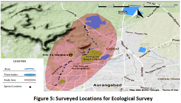 |
Figure 5: Surveyed Locations for Ecological Survey Click here to view figure |
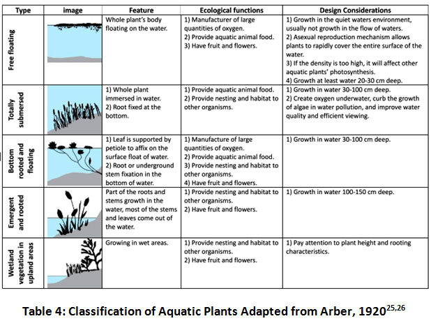 |
Table 4: Classification of Aquatic Plants Adapted from Arber, 192025,26 Click here to view Table |
Flood Control and Aesthetical Aspects
The flood control aspect was studied by carrying out the cross sectional survey from the downstream of Harsul lake to upstream of Chavani bridge. Cross sectional survey was carried out using theodolite at 31 feasible chainages in 8 Km of the study area of Kham River to know the extent of the encroachment and along with it the reduced levels at the cross sections were also calculated.
The aesthetical aspects were studied by transect walks and map surveys for the location of existing historical monuments and tourist attraction places. Along with it places with the potential of aesthetical and recreational development were also surveyed and studied.
Results and Discussion
Water Quality Monitoring
The field testing for the samples is done for dissolved oxygen and total dissolved solids and laboratory testing is done for pH, total suspended solids and biochemical oxygen demand. The obtained results are compared with the standards prescribed by World health organization (WHO)27 and central pollution control board (CPCB)24 as stated in Table 5. The results obtained for rainy, winter and summer season are stated respectively in Table 6, 7 and 8. Similarly the graphical variation of Dissolve oxygen (DO) and Biochemical oxygen demand (BOD) is shown in Figure 6 and 718.
Table 5: Standard Permissible Limits
|
Standards |
WHO |
CPCB |
|
Parameters |
|
|
|
DO |
6.5 – 8.5 |
2.0 – 5.0 |
|
BOD |
10 |
2.0 - 30 |
|
pH |
6.5 – 8.5 |
6.5 – 9.0 |
|
TSS |
50 |
25 |
|
TDS |
|
500 |
Table 6: Laboratory Test Results in Rainy Season
|
Sample |
DO |
BOD |
pH |
TDS |
TSS |
|
Station A |
7.60 |
16.50 |
7.89 |
1264.40 |
315.60 |
|
Station B |
7.70 |
16.50 |
8.03 |
1284.80 |
321.20 |
|
Station C |
6.70 |
19.50 |
7.33 |
1172.80 |
293.30 |
|
Station D |
7.50 |
13.50 |
7.72 |
1235.20 |
308.20 |
|
Station E |
7.20 |
40.50 |
7.51 |
1201.60 |
300.40 |
|
Station F |
6.70 |
22.50 |
7.59 |
1214.40 |
303.60 |
|
Station G |
6.90 |
46.50 |
7.24 |
1158.40 |
289.60 |
|
Station H |
6.80 |
40.50 |
7.38 |
1180.80 |
295.20 |
Table 7: Laboratory Test Result in Winter Season
|
Sample |
DO |
BOD |
pH |
TDS |
TSS |
|
Station A |
6.20 |
17.10 |
7.97 |
584 |
285.20 |
|
Station B |
|
|
|
|
|
|
Station C |
2.12 |
32.30 |
7.63 |
991 |
257.20 |
|
Station D |
2.31 |
28.90 |
7.21 |
782 |
266.90 |
|
Station E |
2.33 |
59.60 |
7.47 |
818 |
248.10 |
|
Station F |
2.38 |
50.20 |
7.87 |
785 |
251.80 |
|
Station G |
1.98 |
61.10 |
7.43 |
849 |
221.70 |
|
Station H |
1.92 |
54.30 |
7.39 |
702 |
231.50 |
Table 8: Laboratory Test Result in Summer Season
|
Sample |
DO |
BOD |
pH |
TDS |
TSS |
|
Station A |
5.94 |
17.90 |
7.10 |
354 |
168.10 |
|
Station B |
|
|
|
|
|
|
Station C |
1.32 |
35.60 |
7.33 |
834 |
216.90 |
|
Station D |
1.52 |
32.40 |
7.62 |
646 |
233.80 |
|
Station E |
1.16 |
62.10 |
7.18 |
631 |
213.10 |
|
Station F |
1.01 |
48.70 |
7.67 |
605 |
226.21 |
|
Station G |
1.11 |
63.40 |
7.82 |
624 |
201.30 |
|
Station H |
1.04 |
59.60 |
7.78 |
614 |
219.70 |
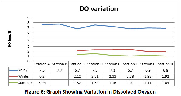 |
Figure 6: Graph Showing Variation in Dissolved Oxygen Click here to view figure |
 |
Figure 7: Graph Showing Variation in Biochemical Oxygen Demand Click here to view figure |
The water quality is good in the upstream reach of the river as compared to the downstream reach. The DO of the water is more in rainy season as compared to winter and summer season, this is due to dilution of the polluted water in rainy season. The DO level depletes in summer as the water in the river is only the dry weather flow. The CPCB standard is hardly achieved in summer and winter due to less DO. The BOD level in the river is less in upstream reach as compared to downstream. Similarly the BOD increases in summer as there is only the dry weather flow in the river. The BOD level as per standard of CPCB should not exceed beyond 30 mg/l, but it is only achieved in the upstream, sampling station. The pH of the water is on basic side. The TSS level is more in rainy season and less in summer and winter as sediments are carried in the river during runoff. Similarly the TDS level in the river water is more in rainy season and less in summer and winter. From the laboratory results, the pH of the water samples ranged from 7.10 to 8.03. This directly implies that the water samples are basic in nature. The BOD values for the Station C to Station H ranges from 13.5 mg/l to 63.4 mg/l and this high value is due to waste discharge in the river18.
Ecological Restoration
The surveyed species of the Aquatic plants are tabulated in Table 9 as per the classification adapted from Arber, 1920. The surveyed species of the birds are stated in Table 10. It is observed that the fishes are present in the upstream stretch of the Kham River; the observed fishes are shown in Figure 8.
Table 9: Classification of Aquatic Plants in Kham River
|
Type |
Name |
Feature |
|
Free Floating |
Lemna Perpusilla |
|
|
Totally submerged |
Spyrogyara |
|
|
Emergent and rooted |
1) Canna 2) Ipomoea Fistulosa 3) Panicum. Sp 4) Cyperus Alopicuroides 5) Typha Anguistifolia |
growth in the water, most of the stems and leaves come out of the water. |
|
Wetland vegetation in upland areas |
1) Arundo donax 2) Prosopis Juliflora 3) Moringa Oleifra 4) Ocimum americanam. 5) Polygonum Glabrum 6) Leucaena Latisiliqua 7) Alternanthera Sessilis 8) Dalbergia sisso 9) Cassia Auriculata 10) Detura inoxia 11) Jatropha Gossipifolia 12) Blumiea Lacera |
|
Table 10: List of the Identified Birds along the Kham River Basin
|
Sr No |
Bird Name |
Sr No |
Bird Name |
|
1 |
Shikra |
25 |
Blyth’s Reed Wabler |
|
2 |
Red munia |
26 |
Red Wattled lapwing |
|
3 |
Scaly breasted munia |
27 |
Tree pipit |
|
4 |
Silver bill munia |
28 |
Oriental magic robin |
|
5 |
Wooly necked stork |
29 |
Black kite |
|
6 |
Purple moorhen |
30 |
Red –vented bukbul |
|
7 |
White spotted fantail |
31 |
Green bee eater |
|
8 |
Black drongo |
32 |
Ashy prinia |
|
9 |
Indian peafowl |
33 |
Tawny-bellied babbler |
|
10 |
Bush quail |
34 |
Indian pond heron |
|
11 |
Glossy ibis |
35 |
Coppersmith barbet |
|
12 |
Black winged kite |
36 |
Greater coucal |
|
13 |
House crow |
37 |
Asian koel |
|
14 |
Brahminy starling |
38 |
Common iora |
|
15 |
Common pigeon |
39 |
Rose –ringed parakeet |
|
16 |
Common hoopoe |
40 |
Common myna |
|
17 |
Long tailed shrike |
41 |
Cattle egret |
|
18 |
Golden oriole |
42 |
Laughing dove |
|
19 |
Barn swallow |
43 |
Red breasted flycatcher |
|
20 |
Paddyfield pipit |
44 |
Common hawk cuckoo |
|
21 |
Indian robin |
45 |
Common sandpiper |
|
22 |
Common tailor bird. |
46 |
kingfisher |
|
23 |
Openbill stork |
47 |
Common kingfisher |
|
24 |
White breasted |
|
|
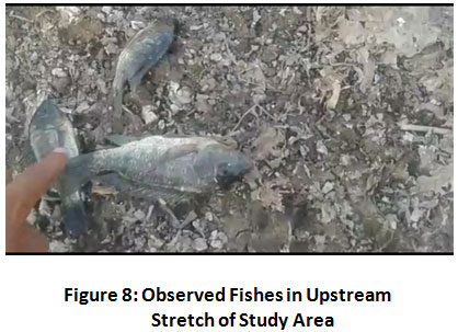 |
Figure 8: Observed Fishes in Upstream Stretch of Study Area Click her to view figure |
Flood Control
The flood control aspect is studied by finding out the extent of encroachment along the river basin which ultimately affected in reduction in the flow path of the river and thus increasing the risk of flooding. The thedolite survey is carried out from the downstream of the Harsul Lake to the upstream of the Chavani Bridge and 31 cross sections are taken at the feasible chainages. The location of the cross sectional survey is shown in Figure 9 and the details of the cross sectional survey is tabulated in the Table 1.
 |
Figure 9: Location of the Cross Sectional Survey Click here to view figure |
Table 11: Details of the Cross Sectional Survey
|
Cross section |
Latitude |
Longitude |
Cross sectional width between two banks in meters |
Reduced level at the midstream in meters |
|
CS 1 |
19°55'32.51"N |
75°19'44.76"E |
45 |
590.075 |
|
CS 2 |
19°55'30.43"N |
75°19'44.68"E |
50 |
581.885 |
|
CS 3 |
19°55'28.69"N |
75°19'44.81"E |
40 |
582.475 |
|
CS 4 |
19°55'26.09"N |
75°19'44.41"E |
22 |
585.680 |
|
CS 5 |
19°55'21.81"N |
75°19'46.78"E |
45 |
583.445 |
|
CS 6 |
19°55'18.68"N |
75°19'49.70"E |
30 |
581.950 |
|
CS 7 |
19°55'13.11"N |
75°19'51.66"E |
28 |
583.040 |
|
CS 8 |
19°55'5.25"N |
75°19'50.40"E |
20 |
581.650 |
|
CS 9 |
19°54'53.77"N |
75°20'1.30"E |
40 |
582.695 |
|
CS 10 |
19°54'44.89"N |
75°20'4.71"E |
52 |
580.760 |
|
CS 11 |
19°54'38.67"N |
75°20'10.07"E |
24 |
580.295 |
|
CS 12 |
19°54'22.82"N |
75°19'54.92"E |
60 |
576.430 |
|
CS 13 |
19°54'21.08"N |
75°19'54.58"E |
28 |
573.790 |
|
CS 14 |
19°54'13.37"N |
75°19'52.47"E |
52 |
573.083 |
|
CS 15 |
19°54'6.63"N |
75°19'46.76"E |
40 |
571.775 |
|
CS 16 |
19°54'6.34"N |
75°19'43.34"E |
68 |
573.200 |
|
CS 17 |
19°54'4.51"N |
75°19'39.86"E |
48 |
570.472 |
|
CS 18 |
19°53'46.41"N |
75°19'13.84"E |
40 |
565.181 |
|
CS 19 |
19°53'45.81"N |
75°19'11.24"E |
52 |
564.255 |
|
CS 20 |
19°53'43.84"N |
75°19'8.96"E |
28 |
564.030 |
|
CS 21 |
19°53'40.52"N |
75°19'7.63"E |
32 |
561.935 |
|
CS 22 |
19°53'37.18"N |
75°19'3.12"E |
28 |
556.140 |
|
CS 23 |
19°53'34.92"N |
75°19'1.04"E |
28 |
555.120 |
|
CS 24 |
19°53'26.60"N |
75°18'58.15"E |
28 |
553.760 |
|
CS 25 |
19°53'16.34"N |
75°18'54.41"E |
20 |
550.800 |
|
CS 26 |
19°53'7.44"N |
75°18'50.50"E |
36 |
546.860 |
|
CS 27 |
19°53'5.76"N |
75°18'49.31"E |
20 |
542.910 |
|
CS 28 |
19°52'58.33"N |
75°18'46.97"E |
28 |
539.260 |
|
CS 29 |
19°52'52.44"N |
75°18'45.49"E |
32 |
537.250 |
|
CS 30 |
19°52'34.81"N |
75°18'39.61"E |
32 |
533.190 |
|
CS 31 |
19°52'32.58"N |
75°18'36.76"E |
24 |
533.080 |
Aesthetical Restoration
The aesthetical restoration aspect is studied by the transect walks and map survey. It can be clearly stated that the Aurangabad city in historical times developed along the banks of the Kham River as there are various historically important sites along the river stretch historical Nahar-e-Ambari the pipe conduit for the water supply run along the river near Harsul lake and up to Panchakki, it is damaged at various places at present. Himayat Baug, a garden with wide variety of Flora species, Panchakki, a hydro powered flour mill and Siddarth garden is situated on the banks of Kham River. Similarly, Bibi-ka-Maqbara is also in the vicinity of Kham River. The Aurangabad city is well mentioned as the city of gates as in the historical times there were 52 gates in the city out of which Makai gate, Mehmood gate and Barapulla gate are on the banks of Kham River. All these historically important places are in the vicinity of Kham River and possess huge potential of tourism and revenue generation if developed accordingly.
Environmental Impact Assessment Using Battelle Environmental Evaluation System
The Environmental impact assessment using Battelle environmental evaluation system for the present condition of the Kham River in the Aurangabad city corresponds to negative value of 375 units. The detailed calculations are stated in Table 12. Entire system is divided in 4 groups as ecology, environmental pollution, esthetics and human interest contributing to total parameter importance unit (PIU) of 1000 as stated in Table 1. The environmental impact units for present condition of the river basin (EIU)1 and past condition of river basin (EIU)2 are applied in range of 0 to 1, where 0 represents poor and 1 represents good.
 |
Table 12: Environmental Impact Assessment Calculations Click here to view Table |
It can be clearly stated that the Kham River is under stress due to negligence for its restoration. The Environmental impact value, thus suggest that there is an urgent need in developing the restoration model for Kham River. In the study area, Kham River from the downstream of the Harsul lake up to Himayat Baug of 3 Km do not have major problem of free flow of untreated sewage whereas this portion of river is subjected to problems such as illegal sand excavation, encroachment, open defecation ,and loose and flat side banks. Kham River is an ephemeral stream which flows only in rainy season and in other seasons only untreated sewage flows through it, hence the portion from Harsul Lake to Himayat Baug have the water quality meeting the standards prescribed by the central pollution control board (CPCB) in rainy season. It is observed that as the dissolved oxygen is above 4 mg/l as fish are found in this portion of river. There is a stone bund near Himayat baug which is heavily silted. The free flow of untreated waste starts near Himayat Baug as the first open drain meets the river at this position, thus beyond Himayat baug up to upstream of Chavani Bridge the problems encountered by the Kham river are free flow of untreated waste, encroachment, dumping of solid waste, heavy vegetation at places, unhygienic living condition in the vicinity and centrally placed sewer drain pipes which affects the flow and its mixing with rain water is a possibility is rainy season. The ecological survey states that there are varieties of flora species responsible in improving the water quality. The extent of the encroachment found out from the cross sectional survey states that the width of the river between two banks varies from 20 meters to 68 meters and the mean value of the 31 cross section is 36.13 meters. The environmental impact unit of the past and present condition of the river have the value of – 375 units; it is indeed needed to restore the Kham River which will enhance the ecology and aesthetics of the Aurangabad city.
Conclusion and Recommendations
The ever increasing impact of urban pollution and the haphazard urban growth on the Kham river are on larger extent. The environmental impact assessment using battelle environmental evaluation system gives the value of -375 units as the Kham river in the Aurangabad city is under severe condition. The study reveals that there is encroachment in the Kham river system on larger extent and this may lead to flood situation in the city area. There is a urgent need to address this issue in order to reduce the risk of flooding and to improve the aesthetics of basin. Thus, from this study, to tackle the issue of the encroachment the mean width of the Kham River between two banks can be taken as 36.13 meters. Water quality in Kham river shows that the level of DO,BOD,TDS,TSS are beyond the standards prescribed by Central pollution control board (CPCB) in dry season. It is seen that there is increase in the DO of water in the wet season and adhering to the standards prescribed by CPCB. The quality of water in the upstream reach of about 3 km is non-polluted and further the point source pollution takes place in river and the water quality depletes. There is need of bank treatment to the river in the upstream side. Species are identified that reduce the pollution load and increase the oxygen in river and provide food for aquatic animals in the river. E.g.:- Lemma Perpusilla. The recommendations based on the conceptual restoration strategy are:
- Kham River originates from the Jatwada hills, thus extensive soil and water conservation (SWC) measures along with the increased plantation in the upstream catchment area will increase the base flow in the dry season by increasing the ground water table and will also reduce the siltation load on the Harsul Lake.
- An integrated approach for the protection of the streams of second and third order in the areas of outskirts of Aurangabad city where infrastructure development is taking place by burying and encroaching the smaller streams contributing the runoff to the Kham River.
- The restoration of the Kham River can be divided into two parts as the portion of the river of 3 km from the downstream of the Harsul Lake to the Himayat Baug and the portion of 5 Km from Himayat baug to Chavani bridge, as the portion of the river on the upstream of the Himayat baug have different issues compared to the portion of the river on the downstream of it.
- The portion of the river of 3 km i.e. from the Harsul Lake to Himayat baug needs special attention on strengthening the side banks of the river by constructing embankments, river deepening and widening at required locations and constructing bunds in series for water retention which can be used for recreational purpose.
- The portion of the river of 5 Km i.e. from the Himayat baug to Chavani bridge needs special attention on river widening by removing the encroachments by taking the mean width of the river as 36.13 meters, aligning the sewer drains to both of the banks is preferable as the portion on top of it can be used as a walkway and microbial beds or green bridge system can be accompanied for enhancing the water quality.
- Plantation along the banks of the river will add to its beauty and enhancing the growth of aquatic species along the basin.
- Repairing and de-silting existing bunds on the river.
- Increasing the awareness among the people to protect the river from encroachment and maintaining cleanliness and hygiene along the river.
- Probable three dimensional restored section is as shown in Figure 10.
- After attainment of all the above recommendations, the detailed zone wise restoration measures can be implemented in the study area by keeping in view the locations of the historical and tourist attractions which will enhance the tourism and will generate the revenue along with it. The zones are shown in Figure 11 and the probable development measures are explained in Table 13.
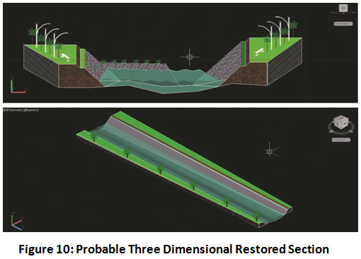 |
Figure 10: Probable Three Dimensional Restored Section Click here to view figure |
 |
Figure 11: Probable Zones for Development of Kham River Click here to view figure |
Table 13: Details of Probable Zones for Development of Kham River
|
Sr. no. |
Zone |
Location |
Existing scenario |
Probable Development |
|
1 |
Zone 1 |
Downstream of Harsul lake |
Non- polluted river stretch, barren area. |
Development of resort between one side of hill and river to take aesthetic advantage of site. Developing strip gardens along the river basin. |
|
2 |
Zone 2 |
Himayat baug |
Mixing of non polluted and polluted water. Old bund present at the site. Heavy silting on the u/s of bund. Observed practice of sand excavation. |
Repairing and removal of silt of existing bund Beautiful water front can be provided at the water stored in the u/s of restored bund. |
|
3 |
Zone 3 |
Begampura |
Polluted stretch. Presence of heavy garbage at the river stretch. Plain terrain and presence of cremation ground. |
Developing parks and garden with beautiful lightning shows as the area in the vicinity of Bibi-ka- Maqbara. |
|
4 |
Zone 4 |
Near panchakki towards university |
Polluted river stretch. Presence of slum at the vicinity of the zone. Barren land and plain terrain. |
Developing library along with mini forest. |
|
5 |
Zone 5 |
Siddharth Garden |
Highly polluted river stretch. Garden present on one side of bank. |
Restoration of Siddharth garden developing river facing landscaping. |
|
Zone 5 and Zone 6 can be connected with beautiful wooden overpass on the river |
||||
|
6 |
Zone 6 |
Opposite of Siddhartha garden |
Highly polluted river stretch. Plain terrain. |
Developing playground for kids. Provision of park for senior citizens. |
|
7 |
Zone 7 |
Behind Mahada colony |
Plain terrain. Heavily polluted stretch. Mixing zone of sewer drain and river. Presence of forest. |
Walking Track And fitness zone, Provision of open gym. |
|
8 |
Gate 1 |
Makai gate |
Unattended assets of city. |
Complete structural restoration. Provision of island with dual oval bridge. And light fountains. |
|
9 |
Gate 2 |
Mehmood gate |
Unattended assets of city. |
Complete structural restoration. Provision of island with dual oval bridge. And light fountains. |
|
10 |
Gate 3 |
Barapulla gate |
Unattended assets of city. |
Complete structural restoration. Provision of island with dual oval bridge. And light fountains. |
|
11 |
Bridge |
Chavani Bridge |
Entrance point of Aurangabad city. |
Replicating Indian flag fountain effect at entry of city. |
Acknowledgement
It’s our privilege to express our sincerest thanks to our project guide Professor Jagdish Godihal, for his valuable guidance, motivation in doing things in perfect way and whole hearted co-operation. We also express our sincere thanks to our faculty members of Civil engineering department, Marathwada Institute of Technology, Aurangabad. We also take the opportunity to thank all those who had been involved directly or indirectly in our project including, Dr Dilip Yardi (Ornithologist), Shri. Arun Kulkarni (Engineer at Irrigation department), Shri. Arun Ghate (Engineer at Irrigation department) and Dr. Pardeshi (Rt. Prof. at Botany department, Dr. Babasaheb Ambedkar Marathwada University).
References
- Baschak LA, Brown RD. An ecological framework for the planning, design and management of urban river greenways. Landsc Urban Plan. 1995;33(1-3):211-225. doi:10.1016/0169-2046(94)02019-C.
CrossRef - Halajova D, Halaj P, Macura V, Skrinar A. Urban River Design: A River Restoration Case Study. IOP Conf Ser Mater Sci Eng. 2019;471(9). doi:10.1088/1757-899X/471/9/092090.
CrossRef - Everard M, Moggridge HL. Rediscovering the value of urban rivers. Urban Ecosyst. 2012;15(2):293-314. doi:10.1007/s11252-011-0174-7.
CrossRef - Grimm NB, Faeth SH, Golubiewski NE, et al. Global change and the ecology of cities. Science (80- ). 2008;319(5864):756-760. doi:10.1126/science.1150195.
CrossRef - Esmee Fairbairn Foundation. River Restoration in Urban Areas.; 2007.
- Zingraff-Hamed A, Greulich S, Egger G, Pauleit S, Wantzen K. Urban river restoration, evaluation and conflicts between ecological and social quality. Erweiterte Zs.fass der Jahrestagung Wien 2016. 2017.
- Walsh CJ, Roy AH, Feminella JW, Cottingham PD, Groffman PM, Morgan RP. The urban stream syndrome: Current knowledge and the search for a cure. J North Am Benthol Soc. 2005;24(3):706-723. doi:10.1899/04-028.1.
CrossRef - Kondolf GM, Pinto PJ. The social connectivity of urban rivers. Geomorphology. 2016;277:182-196. doi:10.1016/j.geomorph.2016.09.028.
CrossRef - Sear DA. River restoration and geomorphology. Aquat Conserv Mar Freshw Ecosyst. 1994;4(2):169-177. doi:10.1002/aqc.3270040207.
CrossRef - R. C. Petersen; Lacoursitre J. A building-block model for stream restoration. River Conserv Manag John Wiley, Chichester. 1992:293-309.
- Cairns J. Restoration of damaged ecosystems. Res Wildl Habitat, US EPA, Washington, DC. 1982.
- Morandi B, Piégay H, Lamouroux N, Vaudor L. How is success or failure in river restoration projects evaluated ? Feedback from French restoration projects. J Environ Manage. 2014;137:178-188. doi:10.1016/j.jenvman.2014.02.010.
CrossRef - Bulut Z, Karahan F, Sezen I. Determining visual beauties of natural waterscapes : A case study for Tortum Valley ( Erzurum / Turkey ). 2010;5(2):170-182.
- Ortolano L, Shepherd A. Environmental impact assessment: Challenges and opportunities. Impact Assess. 1995;13(1):3-30. doi:10.1080/07349165.1995.9726076.
CrossRef - Food and Agriculture Organization of United Nations. Environmental Impact Assessment of Irrigation and Drainage Projects.; 1996.
- Dr. Dilip.B.Boralkar. Bioremediation of Sewage Disposal in the Kham River at Aurangabad (Maharashtra).; 2012.
- Kulkarni SP, Jain SS. Water Quality Assessment of Kham River, Aurangabad, Maharashtra. Int J Eng Res &Technology. 2014;3(4):1502-1511.
- Karhade Vedant & Prof. Godihal Jagadeesh. Water quality monitoring of Kham River, Aurangabad, Maharashtra, India. Int J Civ Eng Res. 2018;6(1):27-29. doi:10.13140/RG.2.2.24876.56963
- [Kham River scene in] Aurungabad [Aurangabad] City. http://www.bl.uk/onlinegallery/onlineex/apac/photocoll/other/019pho0000303s1u00128000.html. Accessed May 20, 2020.
- Dee Norbert, Janet Baker ND and KD. An Environemental evaluation system for water resource planning. Water Resour Res. 1973;9(3):523-535.
CrossRef - Ferreira AP, Cunha C de LN da, Kling ASM. ENVIRONMENTAL EVALUATION MODEL FOR WATER RESOURCE PLANNING . STUDY CASE : Piabanha hydrographic basin , Rio de Janeiro , Brazil. Rev Eletronica Prodema. 1982:7-18.
- Wagh CH, Gujar MG. The Environmental Impact Assessment by Using the Battelle Method. Int J Sci Res. 2014;3(7):82-86.
- Bureau of Indian Standards. Indian Standards Drinking Water Specifications IS 10500:2012. Vol 2.; 2012. http://cgwb.gov.in/Documents/WQ-standards.pdf.
- CPCB. Guidelines for Water Quality Monitoring Central Pollution Control Board Parivesh Bhawan East Arjun Nagar, Delhi-32.; 2007.
- Zhu Jiaying. Criteria for Aquatic Planting Design in Ecological Redevelopment of Urban Riverfronts.; 2012. http://krex.ksu.edu/dspace/handle/2097/14192.
- Arber A. Water Plants C. ambridge Univ Press Wheldon Wesley. 1920.
- WHO. WHO Guidelines for Drinking-Water Quality. Vol 35.; 1989. doi:10.1248/jhs1956.35.307.
CrossRef


