Intra-Crustal Seismicity Triggering in Shillong Massif – An Appraisal on Recent Seismicity
Himanta Borgohain
*

http://dx.doi.org/10.12944/CWE.16.1.22
Copy the following to cite this article:
Borgohain H. Intra-Crustal Seismicity Triggering in Shillong Massif – An Appraisal on Recent Seismicity. Curr World Environ 2021;16(1). DOI:http://dx.doi.org/10.12944/CWE.16.1.22
Copy the following to cite this URL:
Borgohain H. Intra-Crustal Seismicity Triggering in Shillong Massif – An Appraisal on Recent Seismicity. Curr World Environ 2021;16(1). Available From : https://bit.ly/2ZiE8F1
Download article (pdf) Citation Manager Publish History

Introduction
History tells us about the massive earthquakes which collapsed livelihood in different parts of the world in recent time. North-east India is one of the most active seismic zones which experienced a number of devastated earthquakes. The seismotectonic domain of North-east India is delimited between the two great barriers, i.e. the great Himalayas in its north and the Indo-Burma ranges towards far east. The entire NE-India is configured within latitude 22-290N and longitude 90-980E, with the evidence of a number of significant earthquakes, more specifically the earthquakes of 1897 (Ms~8.7) and 1950 (Ms~8.6)1,2 are remarkable. Besides intra-crustal deformation in NE-India, several large earthquakes occurred along Indo-Burma ranges3.
During the 1897 great Shillong earthquake, Chedrang valley and its vicinity in the western part of Shillong massif was considered to be the main rupture zone. Highest ever recorded ground motion was reported in the valley aftermath the earthquake with the attribution of intensity X (Rossi-Forel scale) to the 1897 earthquake in the Shillong plateau4. The major seismotectonic elements participating in the study area are referred in Figure 1. In the present study, detail statistical analysis is pursued to understand the type of seismicity in Shillong massif.
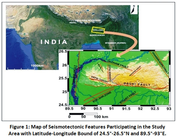 |
Figure 1: Map of Seismotectonic Features Participating in the Study Area with Latitude-Longitude Bound of 24.5°-26.5°N and 89.5°-93°E. Click here to view Figure |
Tectonic Setting
The seismotectonic province of Northeast India portrays the complex geodynamics confined between the two great delimiting structures i.e. the great Himalaya in the northern boundary and the Arakan-Yoma in the far east. The northern collision of the Indian plate with the Eurasian plate results in an evolutionary subduction of the Indian plate beneath the Eurasian, and towards east the subduction of Indian plate beneath the Burmese plate is significant5,6. The tectonic evolution of NE-India is thus characterized as a converging type by the aforesaid mountain ranges.
The seismotectonic domain of Shillong plateau and its vicinity experienced a significant number of earthquakes, remarkably Cachar earthquake of 1869 (M~7.5), the great Assam or Shillong Earthquake of 1897 (M~8.1), Meghalaya Earthquake of 1923 (MS~7.1), Dhubri Earthquake of 1930 (MS~7.1), Assam Earthquake of 1943(MS~7.2), Arunachal Earthquake of 1947 (MS~7.7), Assam Earthquake of 1950 (MS~8.6), Manipur Earthquake of 1988 (MS~7.3), Assam Earthquake of 2009 (M~5.1)6,7 and Sikkim Earthquake of 2011(M~6.9) are the best examples.
The regional complex geodynamics is held responsible for intense intra-crustal deformtion within Shillong massif. Dauki fault acts as a separing structure for the Shillong massif from the Bengal basin in its south. The 320km long Dauki fault is a E-W trended, north dipping, high angle reverse fault8,9. Remote sensing studies by Srinivasan (2003)10 suggest that the eastern part of the Dauki fault i.e. from Borghat area of Meghalaya to Leike in Assam is a single fault rather than the presuming system of faults which dips towards south in a normal faulting pattern, which is in contradiction to Murthy, et al. (1969)9 and Evans (1964)11. Srinivasan (2003)10 further suggested a kind of oblique-slip movement of the Dauki fault owing to the folding signature of tertiary sediments of Surma valley in south of the Dauki fault and pushing further the fault in west. A 90-100km long stretch of NW-SE trended Dapsi thrust is considered to be the Dauki fault’s northwest extension in the plateau, with the signature of strike-slip movement with reverse faulting component12. The Bengal basin’s younger tertiary sediments are separated by the Dapsi thrust to the southwest of Shillong plateau from the rocky complex of the plateau itself in the northeast7,13. Mikir Hills is situated in the northeast end of Shillong massif, which is considered to be de-linked from the Shillong sub-craton by the Kopili detachment fault. The Kopili fault zone covers to the north up-to MBT (Main Boundary Thrust) in the Himalayan counterpart and the area is considered to be major seismogenic zone as studied by Kayal et al. (2006)14; in the same study the depth to bottom of the seismogenic zone in the Kopili region is found to lie at ~50 km. The Kopili fault is considered to be an oblique-slip fault having its dip in N-E direction was treated as a prominent tectonic feature for major earthquakes due to its intense seismicity14,15. The stream of Brahmaputra River separates the Shillong massif from the great Himalayan arc in its north and the N-S trending Dhubri fault separating the plateau from the Indian subcontinent in its west. The intra-seismogenic zone of Shillong plateau is governed by Oldham fault, Chedrang fault, Samin fault, Dudhnoi fault and many more shear zones, etc. All these faults are prominent seismic sources for intense seismicity in the area.
Data and Methodology
The spatio-temporal pattern of earthquake occurrence is known as ‘seismicity’ and the associated earthquake parameters form the seismicity database. The showcase of differential stress release in different parts of the Shillong massif dictates a complex tectonic model for Shillong plateau evolution. Detail seismicity analysis for the entire Shillong massif and its periphery has been carried out from 1098 seismic events occurred during 1966-2013 in the present study.
The seismicity database has been prepared using the sources ISC (International Seismological Centre), local seismological networks of NE-India and some historical large earthquakes information available on literature. The earthquake data has been set to one moment magnitude scale (Mw), wherein different magnitude formats like mb (body wave magnitude), Ms (surface wave magnitude) and M0 has been converted to Mw using formulae given by [Bormann, et al. (2010), Scordilis (2006)]16,17. GMT (Generic Mapping Tool), a command based program has been used while preparing the regional seismicity map. The seismic database contains the informations- origin time, geographical configuration, moment magnitude (Mw) and hypocentral depth. Further, the seismic events have been sorted, according to low, moderate and high magnitude values with distinct colour codes and legends. Different histograms for the earthquakes pertaining to Shillong plateau earthquakes have also been prepared by using MATLAB platform through ZMAP software.
Results and Discussion
Seismicity Analysis
The plateau pop-up mechanism for the Shillong plateau evolution plays a very vital role for the intense seismicity in the region. The seismicity map for the entire seismicity database has been prepared corresponding to their magnitudes with their place of origins. The earthquake magnitude slots are considered in three categories as, <2.99Mw, 3-4.99Mw and 5-7.99Mw. The gross distribution of seismicity pattern for the entire region of Shillong massif and its vicinity has been shown in Figure 2.
The rupture zone of Chedrang valley and its vicinity aftermath the great 1897 Earthquake resembles the most active seismogenic zone in the study area with predominance of earthquakes in the range ≤4.99Mw. The seismicity pattern as evident from Figure 2 reveals that western and the kernel part of Shillong massif is experiencing the sense of neo-tectonism from the prevalent faults and micro-ruptures.
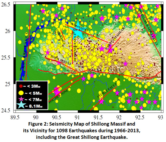 |
Figure 2: Seismicity Map of Shillong Massif and its Vicinity for 1098 Earthquakes during 1966-2013, including the Great Shillong Earthquake. Click here to view Figure |
Figure 3(a), 3(b), 3(c) for depth section views of seismicity suggests that intra-plateau seismicity of moderate earthquakes are predominent in the study region, whereas high magnitude earthquakes i.e. >5Mw are significantly available only in the adjoining parts of Shillong massif owing to the kind of stress release from the major seismotectonic features in the region.
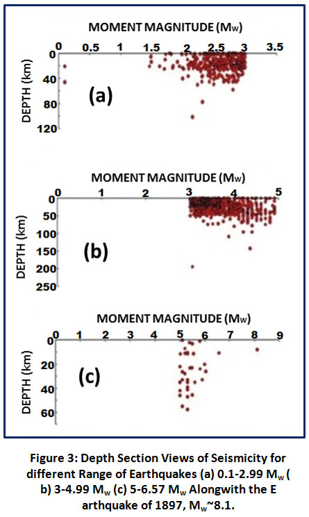 |
Figure 3: Depth Section Views of Seismicity for different Range of Earthquakes (a) 0.1-2.99 Mw (b) 3-4.99 Mw (c) 5-6.57 Mw Alongwith the Earthquake of 1897, Mw~8.1. Click here to view Figure |
Figure 4(a) summarizes the earthquake distribution in terms of moment magnitude (Mw). The recorded seismic events range from 1.46-6.57 Mw, having an average of 3.42 Mw. Only ~2% of the entire data (i.e. 1.82% for 20 earthquakes) have magnitudes less than or equal to 2 Mw. Low magnitude events are very few because of less number of local networks in the study area, which are non-considerable for global GCMT solutions. Again rising above moment magnitude 2 and less than or equal to 3 Mw, a total of 328 seismic events (i.e. 29.89% of the data) have been recorded. The most common magnitude range is 3W≤4, which is nearly 45.12% of the entire data for 495 earthquakes. About 65.45% of the data falls in the range of 3W≤5 for a total of 718 earthquakes, out of which 20.32% of the data for 223 earthquakes fall in the range of 4W≤5. A total of 31 great earthquakes have been recorded over the tenure 1966-2013, making 2.82% of the entire data which fall in the range 5w<7. Out of the whole database, the intensity of 1897 Shillong earthquake of Mw~8.1 was the most devastating one.
Figure 4(b) reveals that in the uppermost layer of the whole study area, the highest amount of 61.99% of the seismic events has been categorized within 10km to ≤40km of hypocentral depth, with an average of 22.31km depth value. Beyond the depth range of 40km, again considerably less numbers of hypocentre are exhibited and the seismic activity starts diminishing beyond 50 km, which was justified earlier in the depth section plots of figure 3.
The earthquakes for the present course of study were occurred from 24/2/1966 to 2/3/2013 (46 plus years). The time distributions for seismic events in the first half of the aforesaid period is very less, only 13.76% of the data was recorded due to less number of seismological networks [Figure 4(c)]. However, with the increase in development of technology and digital environment, more seismic stations were installed in the region, for which a good number of earthquakes were recorded over the period. In the later half of the recording period 946 earthquakes are configured. 373 earthquakes (34% of the data) were recorded from 1990 to 1995, indicating higher tectonic activity.
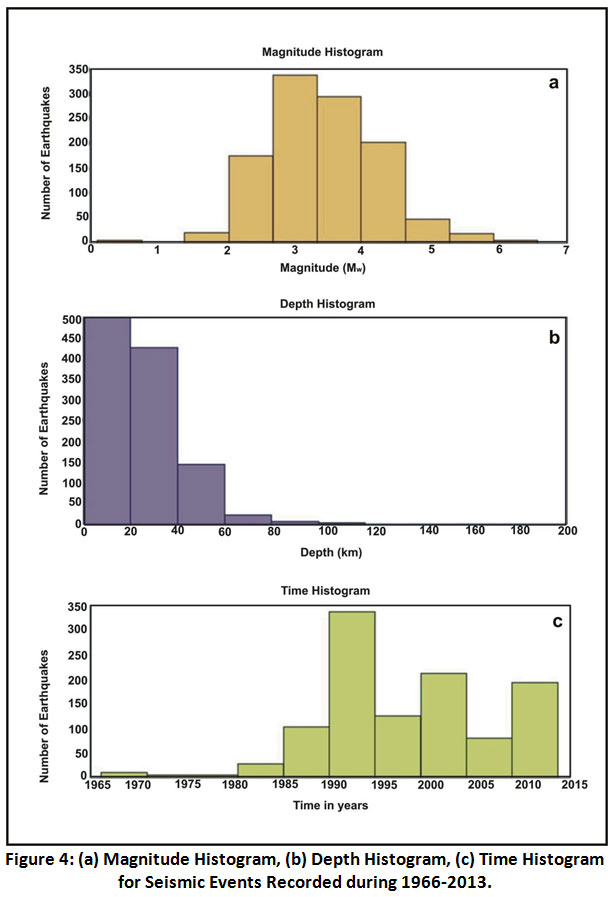 |
Figure 4: (a) Magnitude Histogram, (b) Depth Histogram, (c) Time Histogram for Seismic Events Recorded during 1966-2013. Click here to view Figure |
Conclusion
The intense seismic activity monitored in the study area dictates the kernel and western sector of Shillong massif to be the main rupture area over the recorded period of 1966-2013, where the dominant earthquake magnitude range is ~ ≤4.99Mw; further the intense seismicity distribution also refers for the neotectonics of the prevalent faults as well as micro ruptures in and around Shillong massif at different depth ranges. In the whole study area, within the depth range of 10 to 40km, the highest amount of 61.99% out of 1098 seismic events have been recorded with an average depth of 22.31km. Depth section plots of the seismicity infer the bottom of the seismogenic zone in the Shillong massif to lie at ~40km depth, beyond which a very few earthquakes were reported. However, it should be cited here that in the shallow regime of the uppermost crust (0 to 10km) only 24.15% of the events were recorded. The earthquakes having magnitude in the range 3- 5Mw are predominant in Shillong plateau, comprising 65.45% of the entire data. The average magnitude of the earthquakes is calculated out to be 3.42 Mw. The higher tectonic activity over the studied period is demarcated to be from 1990 to 1995, where a total of 373 earthquakes have been recorded. The time histogram of the earthquake events also reveals that due to inadequate installation of local seismic stations in the study area over the 1st half of the recorded period i.e., from 1966-1990, a very less number of earthquakes could be recorded. From the above study, it can be concluded that the mode of seismicity triggering in Shillong massif is of intra-crustal type with a remarkable intensity of seismicity in and around central and western part of Shillong plateau owing to the Shillong plateau ‘pop-up’ mechanism18.
Acknowledgement
The author is thankful enough to Dr. Saurabh Baruah, Chief Scientist, CSIR-NEIST (Jorhat) for his valuable suggestions while preparing the manuscript.
Funding Source
The author(s) received no financial support for the research, authorship, and/or publication of this article.
Conflict of Interest
The authors do not have any conflict of interest.
References
- Rajendran,C.P., K.Rajendran, B.P. Duarah, S. Baruah, and A. Earnest. Interpreting the style of faulting and paleoseismicity associated with the 1897, Shillong, northeast India, earthquake: Implications for regional tectonism, Tectonics, 2004. 23, DOI:10.1029/2003TC001605.
CrossRef - Devi, R.K.M., and P.K. Bora. The impact of the great 1950 Assam earthquake on the frontal regions of the northeast Himalaya. In: Earthquakes and their impact in society, Springer, 2015, 475-489.
CrossRef - Satyabala, S.P. Oblique plate convergence in the Indo-Burma (Myanmar) subduction region. Pure and Applied Geophysics, 2003, 160(9), 1611-1650.
CrossRef - Ambraseys, N., and R. Bilham. MSK isoseismal intensities evaluated for the 1897 Great Assam Earthquake, Bull. Seism. Soc. Am., 2003, 93(2), 655-673.
CrossRef - Dasgupta, A.B., and A.K. Biswas. Geology of Assam,Geol. Soc. of India, Bangalore, India. 2000, pp-170.
- Anjelier, J. and S. Baruah. Seismotectonics in Northeast India: a stress analysis of focal mechanism solutions earthquakes and its kinematics implications, Geophy. J. Int. 2009, 178, 303-326, DOI: 10.1111/j.1365-246x.2009.04107.x.
CrossRef - Kayal, J.R. Microearthquake seismology and seismotectonics of South Asia, Capital, New Delhi. 2008.
- Baro, O., and A. Kumar. An insight into the Shillong plateau seismicity: A Review, 50th Indian Geotechnical Conference, Pune, India. 2015.
- Murthy, M.V.N., S.C. Talukdar, and A.C. Bhattacharya. The Dauki Fault of Assam, ONGC Bull. 1969. 6, 57-64.
- Srinivasan, V. Deciphering differential uplift in Shillong Plateau using remote sensing, J. Geol. Soc. India. 2003, 612, 773-777.
- Evans, P. The tectonic framework of Assam, J. Geol. Soc. India. 1964, 5, 80-96.
- Islam, Md.S. The tectonic stress field and deformation pattern of northeast India, the Bengal basin and the Indo-Burma Ranges: A numerical approach, Journal of Asian Earth Sciences, 2011, 40(1), 121-131.
CrossRef - Kayal, J.R., and R. De. Microseismicity and tectonics in the northeast India, Bull. Seism. Soc. Am. 1991, 81, 131-138.
- Kayal, J.R., S.S. Arefiev, S. Baruah, D. Hazarika, N. Gogoi, A. Kumar, S.N. Chowdhury, and S. Kalita. Shillong plateau earthquakes in northeast Indian region: complex tectonic model, Current Science.2006,91(1), 109-114.
- Kayal, J.R., S.S. Arefiev, S. Baruah, R. Tatevossian, N. Gogoi, M. Anajam, J.L. Gautam, D. Hazarika, and D. Borah. The 2009 Bhutan and Assam felt earthquakes (Mw 6.3 and 5.1) at the Kopili fault in the northeast Himalaya region, Geomatics, Nat. Hazards and Risk, Taylorand Francis. 2010, 1(3), 273-281, DOI:10.1080/19475705.2010.486561.
CrossRef - Bormann, P. and D. Giacomo. The moment magnitude and energy magnitude: common roots and differences, J. of Seism., Springer Verlag. 2010, 15(2), 411-427, DOI: 10.1007/s10950-010-9219-2.
CrossRef - Scordilis, E.M. Empirical global relations converting Ms and mb to moment magnitude, J. of Seism. 2006, 10, 225-236.
CrossRef - Bilham, R. and P. England. Plateau ‘pop-up’ in the great 1897 Assam earthquake, Nature, 2001, 410, 806-809.
CrossRef


