GIS-based Assessment of Morphological and Hydrological Parameters of Ribeira dos Socorridos and Ribeira do Vigario Basins, Madeira Island, Portugal
Sergio Lousada1,2,3
 and Rui Alexandre Castanho2,3,4,5
*
and Rui Alexandre Castanho2,3,4,5
*
http://dx.doi.org/10.12944/CWE.16.2.08
Copy the following to cite this article:
Lousada S, Castanho R. A. GIS-based Assessment of Morphological and Hydrological Parameters of Ribeira dos Socorridos and Ribeira do Vigário Basins, Madeira Island, Portugal. Curr World Environ 2021;16(2). DOI:http://dx.doi.org/10.12944/CWE.16.2.08
Copy the following to cite this URL:
Lousada S, Castanho R. A. GIS-based Assessment of Morphological and Hydrological Parameters of Ribeira dos Socorridos and Ribeira do Vigário Basins, Madeira Island, Portugal. Curr World Environ 2021;16(2). Available From : https://bit.ly/2VVFUxv
Download article (pdf) Citation Manager Publish History

Introduction
Floods are one of the phenomena that become more and more frequent and destructive due to the disorderly growth of cities and the lack of adequate urban planning 1. Thus, it is clear that floods are the most common type of natural disaster in Europe, taking into account the international database on disasters, representing 43% of all disasters that occurred during the period between 1998 and 20022.
Floods can be defined as extreme hydrological phenomena of variable frequency. These events could be natural or human-induced, consisting of the overflow of a watercourse. 3, 4.
With the increase of this problem at a global level and, mainly in tropical regions, it became necessary to develop measures and devices to mitigate the impacts of floods.
In this context, an in-depth and precise study of the conditions that tend to lead to the aggravation of the aforementioned events in the case of floods is necessary - i.e., geomorphology, geology, hydrology, soil impermeability index, slope, drainage density, among others - and the implementation of mitigation measures for the impacts caused by this type of events 5.
However, even if it is not possible to reduce the impacts of these events to zero, in the future, the effects can be minimized both in the amount of material damage and in the reduction of fatalities 6.
For this, it is necessary to raise awareness on the part of society – i.e., citizens and government officials – for the adoption of risk management mechanisms in the most sensitive areas, such as the hydrographic basins of Ribeira dos Socorridos and Ribeira do Vigário.
Furthermore, flood mitigation structures contribute to the regularization of the volume of water flowing to the mainline, allowing the control of the morphological evolution of the watercourse and the reduction of bed degradation due to the erosion process caused by the transport of solids 7, 8.
In the specific case of Madeira Island, there are no rivers 9. The water lines are called streams. These streams and their tributaries constitute a hydrographic basin that is the fundamental unit for the practical application of hydrology. The hydrographic basin of a watercourse, relating to a given section, is defined as the area of that land that contributes with the water that precipitates there to feed the flow of that same watercourse in the section considered, whose flow converges to a single exit section 10, 11,12.
A stream is a continuous watercourse that typically presents low flows throughout the year, as it also has a small hydrographic basin. These hydrographic basins are characterized by having deep valleys formed by the erosion of rainwater, which, when flowing to the mouth, form slopes in the land. 13, 14.
Due to these large slopes and associated with heavy precipitation, alluviums can occur, the name by which these phenomena are known in Madeira, although in a scientific context it means sedimentary deposits, which originate a strong flow, because due to steep slopes, they will gaining strength and speed, dragging large volumes of solid material, where silting and strangulation of the channel can occur, resulting in the overflow of the flow channels, thus transforming into a highly destructive flow 15.
The characterization of a hydrographic basin is of great importance for the study of its hydrological behavior. Thus, it is interesting to characterize the basin in terms of geometry, drainage system, relief, geology, land use, and vegetation 16.
The main objective of this work is to characterize the main water lines in the municipality of Câmara de Lobos - Madeira Island. This analysis will be carried out in the context of hydraulics, hydrology, and solid transport, so we have the following objectives to develop: (i) characterize the hydraulic and hydrological aspects of the hydrographic basins relating to the Socorridos stream and the Vigário stream in the municipality of Câmara de Lobos – Madeira Island; (ii) a technical approach to solid transport in these water lines and torrential correction actions; and (iii) thus, it is intended to carry out research and data collection, which will later be treated, allowing this information to characterize the respective river basins - several factors make each river basin a different hydraulic and hydrological system depending on its characteristics.
The principal streams to be analyzed will be the Socorridos stream and the Vigário stream, as these are the most representative in this county in terms of area and perimeter.
Materials and Methods
Geographic Location
The island of Madeira is the main island of the Madeira archipelago, of which the island of Porto Santo, the Desertas islands, and the Selvagens islands are also part. The Madeira archipelago is located in the western sector of the Atlantic Ocean about 1000 km southwest of Ponta de Sagres, between the parallels 30º 01' and 33º 08' N and the meridians 15º 51' and 17º 16' W, (see: figure 1)17, 18.
The island of Madeira is the largest island in this archipelago, which has an elongated EW orientation with an area of 742 km2, followed by the island of Porto Santo, which is located just over 50 km northeast of the island of Madeira, with an area of 42.48 km2. To the southwest of Madeira are the Desertas islands, comprising Deserta Grande, Chão islet, and Bugio island, which have an area of 14.21 km2. Finally, about 200 km south of the island of Madeira are the Selvagens islands, composed of Selvagem Grande and SelvagemPequena, covering a total area of 2.73 km217, 18.
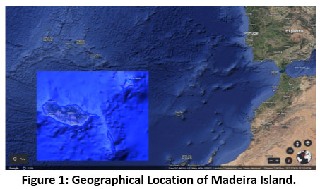 |
Figure 1: Geographical Location of Madeira Island. Click here to view Figure |
Hydrographic Network
The hydrographic network of the island of Madeira is firmly embedded, with straight stretches in significant extensions. The general orientation of the main watercourses is radial, and the straight alignment is maintained practically from the source to the mouth in the sea. An upstream stretch of the Socorridosstream constitutes an alteration to these predominant directions19.
This hydrographic network comprises more than 200 watercourses that are mostly radial (see: figure 2). The watercourses that make up this network are torrential, reflecting the relief of the islands and the regime of precipitation. Almost all the main streams have unevenness of more than 1200 meters and rarely exceed 20 kilometers in length. Concerning its material composition, the beds are composed, in general, by rocky sediments, where it is very rarely possible to observe the deposition of fine sediments.
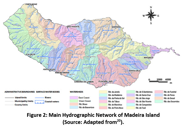 |
Figure 2: Main Hydrographic Network of Madeira Island (Source: Adapted from20). Click here to view Figure |
The north side of the island comprises numerous and small streams, which, even in summer, have a significant flow, unlike the streams on the south slope of the island, whose flow in the summer period is almost non-existent.
The hydrographic basins of the island of Madeira are, in general, not very wide and elongated and with small areas. The one with the most significant area is the Ribeira dos Moinhos with about 66.92 km2, followed by the Ribeira do Faial with 66.24 km2 and the Ribeira dos Socorridos with 63.31 km2. The average altitude of the main watercourse basins varies between 875 meters, the highest, the Seixalstream, and 181 meters for the lowest average, the Serrado stream. These also have a steep slope, the one with the highest slope, 21.32% the Madalena creek, and the one with the slightest slope is the Janela creek, with values in the order of 7.11%. Table 1 summarizes all the general characteristics of the main hydrographic basins on the island of Madeira.
Table 1: Main Basins / Watercourses of Madeira Island. (Source:20, 21).
|
Main Basins / Watercourses |
Basin Area |
Basin Perimeter |
Average Altitude of the Basin |
Length of Main Watercourse (m) |
Maximum Main Watercourse |
Average Slope of Main |
|
Rib. da Boaventura |
10,79 |
20,813 |
739 |
10626 |
1350 |
12,68 |
|
Rib. Brava |
44,58 |
33,963 |
755 |
13643 |
1540 |
11,29 |
|
Rib. do Campanário |
10,45 |
18,297 |
618 |
8401 |
1420 |
16,90 |
|
Rib. do Faial |
66,24 |
47,328 |
712 |
14526 |
1493 |
10,27 |
|
Rib. da Janela |
62,52 |
50,314 |
843 |
21987 |
1564 |
7,11 |
|
Rib. de Machico |
30,35 |
27,874 |
395 |
12384 |
1035 |
8,36 |
|
Rib. da Madalena |
16,30 |
21,387 |
742 |
6545 |
1396 |
21,32 |
|
Rib. dos Moinhos |
66,92 |
40,020 |
634 |
9558 |
1231 |
12,87 |
|
Rib. da Ponta do Sol |
30,02 |
27,245 |
837 |
11842 |
1566 |
13,22 |
|
Rib. do Porco |
34,69 |
27,136 |
695 |
10245 |
1485 |
14,49 |
|
Rib. do Porto Novo |
38,31 |
32,927 |
552 |
12913 |
1379 |
10,68 |
|
Rib. de Santa Cruz |
18,38 |
23,277 |
556 |
10329 |
1273 |
12,33 |
|
Rib. de Santa Luzia |
61,55 |
43,311 |
581 |
11548 |
1695 |
14,68 |
|
Rib. de São Bartolomeu |
31,59 |
25,679 |
607 |
6775 |
1201 |
17,72 |
|
Rib. de São Jorge |
54,66 |
34,568 |
646 |
10409 |
1399 |
13,44 |
|
Rib. de São Vicente |
48,16 |
32,456 |
747 |
10291 |
1640 |
15,94 |
|
Rib. do Seixal |
30,36 |
31,242 |
875 |
10472 |
1569 |
14,93 |
|
Rib. do Serrado |
13,45 |
46,285 |
181 |
3872 |
592 |
15,29 |
|
Rib. dos Socorridos1 |
38,62 |
36,84 |
599 |
17210 |
1660 |
9,74 |
|
Rib. da Tabua |
9,37 |
18,215 |
684 |
7604 |
1505 |
19,76 |
|
Rib. do Vigário1 |
15,42 |
19,56 |
401 |
9270 |
1323 |
12,48 |
Hydrology and Hydrogeology
The hydrological activity is divided into two branches, surface runoff, and underground runoff. The sum of these two, results in the total potential runoff.
On Madeira Island, the average precipitation values allow water resources with values higher than the average water needs. However, despite this situation, the inability to regularize surface runoff means that it has to be compensated using groundwater.
There are substantial differences between the north and south sides of the island. On the north side, there is greater availability and fewer needs; the opposite happens on the south side, especially the east, where there is less availability and greater needs 9.
Surface runoff arises from precipitation in hydrographic basins, proliferating runoff over the surface of the land. On the island of Madeira, runoff increases significantly with altitude, with the lowest values occurring along the coast.
The underground flow occurs essentially in areas of higher altitude and less slope, where precipitation reaches high values and volcanic formations are more recent; therefore, more permeable, thus allowing its infiltration.
According to Explanatory News VII.3 of the Ministry of Environment and Natural Resources, the hydrogeological behavior of volcanic formations on the island of Madeira is influenced by:
- by the age of the prevailing lithology;
- by the existing geotectonic structures (fractures and pile network);
- c) by porosity and permeability values, in a geological context.
- areas favorable to infiltration;
- high productivity local and discontinuous aquifers;
- aquifers of moderate and high productivity, with only local reserves;
- unproductive aquifers or possibly good productivity, in very localized areas.
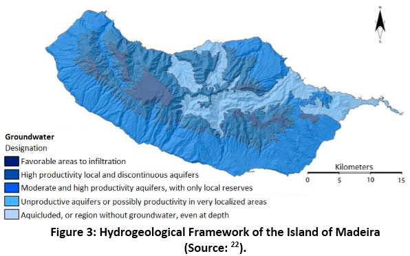 |
Figure 3: Hydrogeological Framework of the Island of Madeira (Source: 22). Click here to view Figure |
According to Prada et. al. 23 the hydrogeological model of Madeira Island differentiates its aquifers into three different typologies: (i) suspended aquifers, (ii) base aquifer, and (iii) compartmentalized aquifers.
Suspended aquifers are located at a higher altitude and are formed when infiltrated water encounters a poorly permeable or impermeable layer and is retained. These are further subdivided into superficial and deep. The first ones are located at a higher level and are more vulnerable to climate variations, their flow varying throughout the hydrological year, depending on the recharge, some of them even depleting. The deep suspended aquifers are also located at altitudes, but lower, and their flows are less sensitive to climate variations.
The base aquifers are located from a certain depth due to the heterogeneities and discontinuities that characterize the volcanic environments. In these contiguous aquifer partitions, there are different piezometric levels.
The compartmentalized aquifers are because volcanism in Madeira is generally of the fissure type. The entire volcanic building is crossed by subvertical veins that limit the base aquifer, thus giving rise to potential variations between nearby compartments. This compartment is responsible for compartments or dry cells located in areas that do not receive recharge.
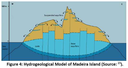 |
Figure 4: Hydrogeological Model of Madeira Island (Source: 23). Click here to view Figure |
Characterization of the Main Water Lines (Streams)
Geographic Location
Through the computational software of the Geographic Information System (ArcGIS) and the shapefiles provided by the Atlas of the Digital Environment (Instituto do Ambiente), it was possible to determine the geographic location of the hydrographic basins under study.
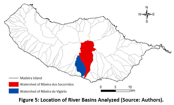 |
Figure 5: Location of River Basins Analyzed (Source: Authors). Click here to view Figure |
The river basin of Ribeira dos Socorridos is located in the east sector of the municipality of Câmara de Lobos and the borders the hydrographic basins of the municipality of Funchal to the east, to the north with the hydrographic basins of Santana and to the west with the river basin Vigário and Ribeira Brava, and to the south where the Atlantic Ocean flows.
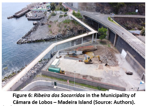 |
Figure 6: Ribeira dos Socorridos in the Municipality of Câmara de Lobos – Madeira Island (Source: Authors). Click here to view Figure |
The river basin of Ribeira do Vigário is located in the central-south zone of the same municipality and is bounded to the east by the river basin of the Socorridosriver, a small strip to the north by the river basin of Ribeira Brava, to the west by the river basins of the river Caldeira and do Campanário form the border and to the south where the mouth is located in the Atlantic Ocean.
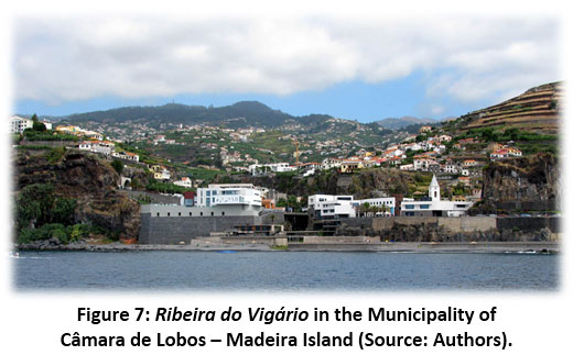 |
Figure 7: Ribeira do Vigário in the Municipality of Câmara de Lobos – Madeira Island (Source: Authors). Click here to view Figure |
This information only serves for a preview of the geographic location of the hydrographic basins, being subsequently made the delimitation of them and the drainage network through digital terrain models.
Physiographic Characteristics
Climatic Characterization
The factors that characterize the climate in this hydrographic basin are the same that affect the entire island of Madeira. Using the shapefiles of the Atlas of the Digital Environment again (Instituto do Ambiente) and the ArcGis Geographic Information System software, a climate analysis of the Socorridos river basin was carried out, relative to the annual average temperature and the average annual precipitation in the period between 1960 to 1991.
Geological Characterization
Through the projection of the respective hydrographic basins under study in the geological map of the island of Madeira through the ArcGis software, it is possible to better perceive the phases of volcanic eruption relative to each one of them.
Soil Characterization
In the river basin of Ribeira dos Socorridos, contrary to what happens in most of the islands of Madeira, the most representative soil group is the Accident Terrane, namely the subgroup District Terrain Accident (TAd), which is present from upstream and tapers - towards the downstream. There is also a small extension to the east and central part of the hydrographic basin that belongs to the subgroup of Umbric Andosols (ANu). Finally, near the mouth, we have three subgroups in a small, unrepresentative extension, there is the Eutric Rugged Terrain (TAe), EutricFluvisols (FLe), and Haplic Phaeozems (PHh) (Figure 8).
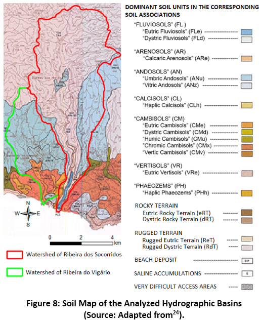 |
Figure 8: Soil Map of the Analyzed Hydrographic Basins (Source: Adapted from24). Click here to view Figure |
Regarding the Vigário river basin, as in most of Madeira Island, in the central area of this basin is the group of soils present in the majority, the Andosols (AN), more specifically the Umbric Andosols ( ANu). Only a small part in the far north is composed of Distride Rugged Terrain (TAd). In the southern part of the basin, there are other types of soils such as EutricCambisols (CMe) and Chromic Cambisols, both belonging to the Cambisols (CL) and also a small area with Vitric Andosols (ANz) and Haplic Phaeozems (PHh) (Figure 8).
Methodology
According to the diagram shown in Figure 9, the present work was developed with a research and literature review on the topic, followed by preparing an inventory - where a visual analysis of the areas under study was made. Through a photographic characterization (photos and images) and the collection and treatment of digital terrestrial maps through the ArcGis software, the organization, treatment, and analysis of all the results/data obtained were subsequently preceded by the organization, treatment, and analysis of all the results/data obtained. As a final step, the conclusions related to the work developed were presented.
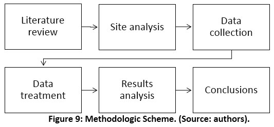 |
Figure 9: Methodologic Scheme. (Source: Authors). Click here to view Figure |
Results and Discussion
Geometric Characteristics
Nowadays, due to technological advances, all geographic data are digitized. Using the geographic information system software, namely the ArcGis software, it is possible to analyze the digital terrain models and thus obtain all the necessary data to characterize the hydrographic basin. For this purpose, the “Spatial Analyst” module is essentially used, which provides tools for the advanced and sophisticated construction of analyzes and the creation of different spatial models9.
The digital terrain models were provided by the Directorate of Geographic Information and Cadastral Services of the Autonomous Region of Madeira, which is a set of cartography files in “Raster” format, with all the necessary altimetry to analyze the hydrographic basins.
Relief Features
Through the hypsometric curve, it is possible to characterize the relief and altimetry of a hydrographic basin, relating the altitudes of the terrain surface (in ordinates) with the basin areas located above these altitudes (in abscissa). Thus, we can affirm that the relief of the hydrographic basin is graphically represented. This represents the study of the variation in elevation of the various terrains in the basin in relation to the mean sea level. Through this hypsometric curve, it is possible to determine the maximum altitude, the minimum altitude, and the average altitude.
Contextually, to define the hypsometric curve, the digital terrestrial models of the basin in the ArcGis software were used. Contour lines of 100 in 100 meters were defined; thus, it was possible to obtain, through the automatic calculation of this software, the corresponding area between each level curve from the mouth to the highest point of the hydrographic basin. Figure 10 shows the hypsometric map of the hydrographic basin of Ribeira dos Socorridos and Ribeira do Vigário obtained using the ArcGIS software.
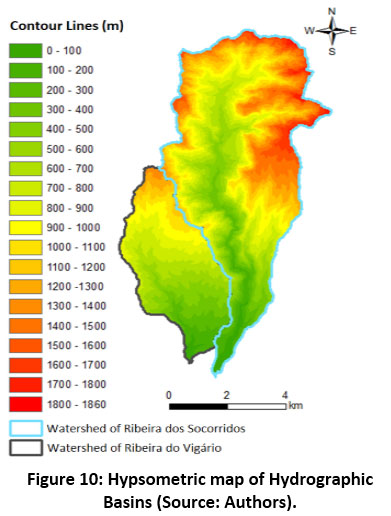 |
Figure 10: Hypsometric map of Hydrographic Basins (Source: Authors). Click here to view Figure |
Through the visualization of the attributes table of this hypsometric map in the ArcGis software, it was possible to determine the maximum altitude of the hydrographic basin of the Socorridosstream, which was Zmax = 1860 m, and, that of the Vigário stream, it was Zmax = 1410 m. Regarding the minimum altitude, since both basins flow into the Atlantic Ocean, then their minimum altitude is Zmin = 0 m.
Drainage Network Characteristics
The drainage network is a natural system made up of several interconnected channels capable of transporting surface water, essentially from rain to the mouth.
A drainage network can have different shapes, from the most complex to the simplest, depending on its type of branch. The most common are dendritic, radial, angular, and parallel drainage networks.
Regarding the type of drainage from the network, there are two distinct forms, the endorheic when the watercourse does not flow to the sea or ocean, and the exoteric when the watercourse has an outlet to the sea or ocean.
The Socorridosriver basin and the Vigário river basin have a dendritic drainage network as the water lines run in all directions. This network resembles the branches of a tree. As for the drainage type, as both hydrographic basins flow into the Atlantic Ocean, they are classified as exoteric. In short, all the parameters that allow characterizing the respective drainage network were calculated (see: table 2).
Table 2: Summary of the River Basins Characteristics (Source: Authors).
|
Parameter |
Ribeira dos Socorridos |
Ribeira do Vigário |
|
Area |
38,74 km2 |
15,42 km2 |
|
Perimeter |
37,50 km |
19,91 km |
|
Gravelius compactness index (KC) |
1,70 |
1,43 |
|
Elongation index (KL) |
6,95 |
4,19 |
|
Form factor (KF) |
0,12 |
0,27 |
|
Average altitude (Zmed) |
931,41 m |
663,84 m |
|
Average height (hmed) |
931,41 m |
663,84 m |
|
Length of main watercourse (L) |
17673,12 m |
9415,21 m |
|
Maximum altitude of the main watercourse |
1475 m |
1320 m |
|
Average slope of the main watercourse (imed) |
0,083 |
0,140 |
|
Equivalent height of the main watercourse (Zeq) |
787,90 |
1049,13 |
|
Equivalent slope of the main watercourse (ieq) |
0,045 |
0,111 |
|
Slope 10-85 (i10-85) |
0,057 |
0,125 |
|
Relief index (irelief) |
0,141 |
0,186 |
|
Average slope of the basin |
40,76º |
24,97º |
|
Average slope of the basin |
86,20 % |
46,57 % |
|
Strahler's Hierarchy |
Order 5 |
Order 4 |
|
Number of watercourses |
528 |
207 |
|
Total length of watercourses |
125,257 km |
70,664 km |
|
Shreve Hierarchy |
Magnitude 250 |
Magnitude 104 |
|
Average Bifurcation Ratio (Rb) |
1,56 |
1,87 |
|
Concentration time (Témez) |
1h08m |
0h48m |
|
Concentration time (Ven Te Chow) |
1h20m |
0h45m |
|
Concentration time (Giandotti) |
2h06m |
1h27m |
|
Average Concentration time |
1h32m |
1h00m |
|
Drainage density (Dd) |
3,23 km/km2 |
4,58 km/km2 |
|
Average course over land (PL) |
154,8 m |
109,2 m |
|
Water density (Dh) |
14 watercourses /km2 |
14 watercourses /km2 |
The flood peak flow for each of the hydrographic basins will be calculated using the rational method, where only liquid flows will be addressed, that is, only composed of water, whose equation is:
The flood peak flow (Q) is expressed in m3/s for a return period T (years), the runoff coefficient (C) is a dimensionless value, the average rainfall intensity (i) is expressed in mm/ h, and the value of the area (A) used is in km225.
Return period (T) describes the predicted (mean) time (in years) within the exceedance of a specific, extreme origin. Return period is usually applied to display the incidence of the existence of an event - even if it often misinterpreted as being a possibility of happening5.
The runoff coefficient (C) essentially considers precipitation losses, including, albeit with different relative importance, interception losses, infiltration, surface retention and evapotranspiration, and runoff diffusion. This coefficient is also a function of the return period, increasing with the increase of the return period, in order to express the decrease in precipitation losses26.
Precipitation intensity (i) is a necessary parameter to apply the rational formula. To this end, we used the intensity/duration/frequency curves (IDF), recommended by Matos and Silva27, considering the duration of precipitation equal to the concentration-time (t), which corresponds to the most unfavorable situation.
After collecting the previous data, it is possible to calculate the flood peak flow for each of the hydrographic basins (Equation 1).
Table 3: Peak Flood Flow of Hydrographic Basins (Source: Authors).
|
|
Flood tip flow (m3/s) |
|
Ribeira dos Socorridos |
168,32 |
|
Ribeira do Vigário |
87,18 |
The results of this study corroborate the DROTA’s Flood Risk Report10. In fact, the report allows us to consider this study’s outcome both satisfactory and valid.
Moreover, this study allowed us to characterize these hydrographic basins in Madeira. Contextually, it will undoubtedly be an essential contribution to classifying each hydrographic basin of the island, taking into account the risk of flooding and the resulting impact on people's lives.
Solid Transport and Torrential Correction Measures
The study of reliable transport in a hydrographic basin is challenging to carry out. There are generally no points in the streams where the volume of moving sediments can be measured. The quantification of this volume itself is challenging to measure.
The solid material that converges to the hydrographic network and is transported by river flow starts in sedimentological processes that act in the hydrographic basins and depend on several mechanisms associated with the occurrence and flow of water.
Hydrological behavior, land morphology, land use, and occupation, among others, correspond to the sequence and temporal succession of mechanisms of erosion, transport, and sediment deposition, in which water is its primary cause. During the erosive process, we can distinguish the following phases:
- surface rock weathering;
- fragmentation of soil and surface rocks;
- detachment of surface particles by erosive agents, which includes the removal of sediments produced by mass movements, precipitation, and runoff;
- transport of eroded sediments;
- sediment deposition;
- sediment consolidation.
As the primary sources of solid material, it is possible to distinguish the following types of erosion of the interfluvial space:
- distributed erosion caused by distributed runoff on slopes and reception basins;
- localized erosion resulting from concentrated flow that causes furrows, ravines or incision in incipient channels;
- mobilization of sediments from slope or mass movements by distributed or concentrated flow.
These sediments, after being eroded and through runoff, are transported by slopes or by the drainage network and can be classified according to their transport capacity as:
- erosion torrents;
- transport torrents, or in balance;
- deposition torrents.
Sediment transport consists of several stages in a drainage network, namely:
- sediment feed to the drainage network;
- incorporation of tributary sediments, to water courses, in the outflow flow;
- detachment of sediments from the bottom and banks of the beds;
- sediment transport;
- sediment deposition.
Concerning sediment transport, where the hydraulic transport capacity is greater than the sediment feed, the consequences are shown by generalized or localized erosion. This type of erosion can have the following characteristics:
- bottom incision;
- flooding of terraces and alluvial deposits;
- landslides on the banks and the base of slopes;
- erosions located on obstacles, in beds or protruding on the banks.
Solid Transport Characterization
Solid transport in channels with a movable bottom can be classified, depending on the origin of the materials, in:
- transport of the bottom material, corresponding to materials whose granulometry is present in the bottom;
- transport of washing material, corresponding to materials smaller than those of the bottom materials and of origin outside the bed of the section under consideration.
As the bottom solid material moves, several increases in flow velocity cause an increasing volume of particles to roll and slide over each other. According to Quintela4, there are three modes of solid transport, which are presented in the order of decreasing average, typical dimensions of transported grains:
- solid drag transport, in which particles roll or slide over the bottom;
- solid transport by jumping, in which particles move alternately by small jumps or by slipping and rolling over the bottom;
- suspended solid transport, in which particles move within the flow, sporadically contacting the bottom.
Torrential Correction Measures in Hydrographic Basins
When a hydrographic basin experiences intense erosive activity, which can cause some torrentiality in the fluvial regime, especially the tributaries of the upstream sectors - due to the slope of the slopes and the absence of vegetation cover, it is necessary to try to minimize the consequences of this same erosive activity and torrential.
Due to the particular geological and geomorphological nature of Madeira Island, most areas of the river basins are conducive to high production of solid material flows, which constitute the most dangerous component of the alluvium that occurs on the Island. Therefore, reducing the total volume of solid material displaced is a priority measure for risk management and protection against the consequences of alluvium.
Implementing systems or transversal structures for interception and temporary retaining solid material is considered a priority measure for protecting critical areas exposed to danger. The various types of works and interventions that can be implemented are described in the following subsections.
Dams
Dams are generally structures built with erosion-resistant materials, which help reduce the flow of water and increase the deposition of solid material28, 29, 30.
In fact, installing a dam alters the sedimentary and morphological environment of a watercourse - making it necessary to study its environmental and social impact in engineering work. So, to understand the influence of the dam at a sedimentary level, it is necessary to perceive the effects upstream and downstream, namely during and after a flood. Most of the sediment transport occurs during a flood when higher flows are present, and consequently, there is a greater transport capacity28, 29.
The construction of a dam results in creating a reservoir upstream of the dam - resulting in a reduction in the flow velocity and consequent deposition of solid cargo; also causing a process of reducing solid transport downstream 28, 29.
As the total solid transport is proportional to the flow velocity, with the speed reduction, the amount of transported solid is also reduced, deposited upstream of the dam. The dead volume of the reservoir is composed of larger sediments that accumulate right at its entrance, sometimes forming a delta, and smaller particles, which remain in suspension for longer and are deposited further downstream, near the face of the dam 30.
Cross Sills
Transverse sills are commonly known as indents and are particularly suitable for mountain streams. These have as their primary function to control the erosion of the bottom and banks and to avoid generalized deposition downstream 31, 32 (Figure 11).
The transversal sills in the beds of the watercourses are used to fix the bottom of the bed, reduce the flow velocity, the transport capacity, and the erosion. Besides, this fact conducts to the fluvial rebalancing. They are applied to promote sediment retention, reduce solid transport on the bottom, fix the equilibrium slope of the thalweg, and stabilize the margins (Figure 11).
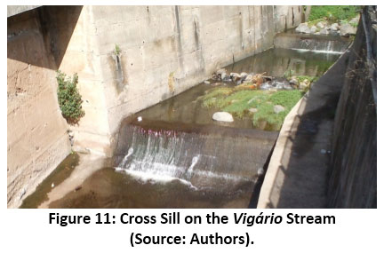 |
Figure 11: Cross Sill on the Vigário Stream (Source: Authors). Click here to view Figure |
Spurs
Fluvial spurs are smoothing structures built across the main bed from one of the banks, occupying only part of the width of the respective cross-section. The primary purposes of these structures are to provide the concentration of the flow in well-defined sections and stabilize sections of the flow to minimize the general erosion of the bottom and banks 32.
Thus, the spurs deflect and guide the flow vein and protect the banks from erosion. These can be recessed directly into the edges or in continuous edge protection. According to the adopted geometry, the spurs promote the retention of sediments - i.e., fixing the level of the bed at the base of the margins and deflecting the thalweg of the watercourse to the central area of the bed.
The spurs can be classified as closed or open; they can have submerged or submerged crests, totally or partially, and horizontal or submerged profiles in both cases. Closed groins are solid structures with a core that, for economic reasons, is generally constructed from the material of the bottom of the watercourse, protected by a coating. Open spurs are structures that allow a significant part of the flow to be percolated through them, deflecting the flow less than closed spurs (Figure 12).
Just after the downstream of the spurs, the streamlines have a concave curvature relative to the margin where the respective abutment is located, which leads to the movement of the bottom material towards that margin and the consequent local silting 32.
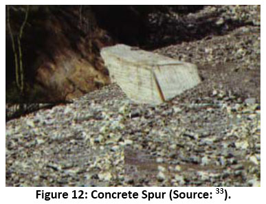 |
Figure 12: Concrete Spur (Source: 33). Click here to view Figure |
Weirs
Weirs are heavy structures built in concrete, which are generally open, with one or more openings, or a grid.
The weirs can have different formats and configurations, depending on the characteristics of the place to be implemented. But all of them have the main function: let smaller sediments pass through that do not cause damage and retain large sediments that could cause danger to the areas downstream of the place where they are installed. The effectiveness of these open weirs in preventing alluvium has been proven in several studies carried out in Japan. All these studies have concluded that changing the spacing between the openings of the weir can reduce the destructive effect of the alluvium, allowing sediment to pass between the openings. smaller and retaining those with the most significant destructive potential 34, 35, 36.
This type of structure was recently built in the municipality of Funchal, namely on the São João stream, on the Santa Luzia stream (Figure 13), and on the João Gomes stream. Twelve open weirs were built to retain large solid material and prevent it from reaching the mouth and downtown, as has already happened, namely on February 20, 2010.
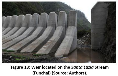 |
Figure 13: Weir located on the Santa Luzia Stream (Funchal) (Source: Authors). Click here to view Figure |
Coating of the Bottom and Margins
The lining of the bottom and banks, or the channeling of a stream, aims to protect the banks and the bottom to protect them from erosion and under-excavation (Figure 14). This coating, typically made in concrete, allows an increase in flow in order to ensure the transport of sediments, avoiding the silting of solid material in unwanted places 37.
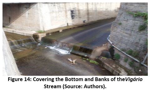 |
Figure 14: Covering the Bottom and Banks of theVigário Stream (Source: Authors). Click here to view Figure |
This measure is recommended in hydrographic basins subject to strong erosion, especially in urban areas and in places with large torrential flows. This solution also allows for greater consistency of the slopes that flank the streams, but on the other hand, it has a strong environmental and visual impact.
Floods Mitigation Measures
According to Reis8, flood mitigation works contributes to the “(…) control of the volume of water flowing to the main routing line, allow the control of the morphological evolution of the watercourse, also allows a reduction in solid transport and prevents erosion of the banks and bed of the watercourse”.
Floods mitigation measures are subdivided into two groups – i.e., structural and non-structural measures.In this regard, Table 4 shows the purpose and practical examples of each of the groups of mitigation measures 11.
Table 4: Types of Flood Mitigation Measures (Source: Authors).
|
|
Measures |
|
|
Origen |
Structural |
Non-structural |
|
Aim |
(at administrative level) reduce one or more flood parameters, from a hydraulic or hydrological point of view, at the level of floodable areas – flow, the height of the flood, etc. |
(at the level of ownership), established at governing, normative and legislative levels – i.e., DL n.º 130/2012, June. |
|
Examples |
Dams and retention basins. |
Municipal emergency plans. |
|
Modification in the bed and river regularization. |
Flood warning and forecasting systems. |
|
|
Modification in the drainage basin. |
Flood Insurance. |
|
|
Minimization of waterproofed areas. |
Repair and restoration of vegetation in watersheds, especially in areas adjacent to the hydrographic network. |
|
|
Building protection. |
Training and information to the public (in general). |
|
Enlarging the research to other case studies (namely at the national level), it becomes possible to verify other measures to mitigate the risk of structural and non-structural floods that can be implemented in the region. Some examples are listed below:
Structural Measures
- Desilting: Measure of removal of sediments accumulated at the bottom of the stream;
- Relocation of buildings - Buildings within the limits of the Public Water Domain, adjacent areas, on the banks or the bed of streams and their tributaries, should be the subject of reflection. Due to the characteristics and degree of threat it represents, this building must be the target of a relocation proposal.
- Creation of a Tide-Precipitation alert system - The proposed system must relate, in real-time, the precipitation values with the tides. Thus, whenever there is a high amount of precipitation (equal to or greater than the values that triggered the last floods occurred in Madeira Islands back in 2010), combined with the period of high tide, an alert should be issued to the Civil Protection resources;
- Bringing alert systems closer to the population - The proposed system considers the issuance of alerts and communications to the population through mobile communication devices. Therefore, an application for the iPhone and Android systems should be made available, free of charge, which issues alerts and communications in real-time to all users.
- Flood insurance - Strategy that determines the obligation to carry out flood insurance by all owners who have assets within the areas delimited as adjacent areas to the streams and in the public water domain;
- Exchange of land - The exchange of land between the municipality and its owners (public or private entities) must be carried out and promoted whenever necessary for flood mitigation;
- Regular monitoring of heritage elements and sites - Heritage elements and archaeological sites should be regularly monitored, evaluated explicitly after works or flood episodes to establish a proposal for the affected elements whenever justified.
Conclusions
In the last two decades, there has been a significant investment in the characterization of the hydrographic basins of the island of Madeira and the accounting of solid transport, contributing to local and regional development in terms of river hydraulic infrastructure accounting devices and introduction of mitigating measures. This, to avoid or minimize natural disaster situations (alluvium) and safeguard the well-being of the population of the island of Madeira.
The present work focuses on studying the characterization of the hydrographic basins of the Socorridos andVigárioriver basins on the island of Madeira and the accounting of their solid transport. Concerning the characterization of the hydrographic basins, it was intended to evaluate the morphometric characteristics of the hydrographic basins of the Socorridos and Vigário river basins. To carry out the morphometric characterization of these basins, it was necessary to delimit the areas, perimeters, and axial lengths of these basins with the help of ArcGIS software, with the help of which all the indices/descriptive parameters of a hydrographic basin were characterized. These indices/parameters linked to the region's climate explain the need for human intervention to construct river hydraulic infrastructure and implement mitigation measures.
Solid transport is a natural, complex, and interdependent process, which is increasingly affected by anthropogenic impacts, often leading to the need to carry out maintenance interventions on river hydraulic infrastructure.
Since this is an essential issue for Madeira Island, there is every need to characterize the processes it involves, being the same subject of the development of some research works. This, due to the particular geological and geomorphological nature of the Island of Madeira, and most of the areas of the river basins are conducive to high production of solid material flows, which constitute the most dangerous component of the alluviums that occur in the Island. Therefore, there is a need to reduce the total volume of solid material displaced, which is a priority measure for risk management and protection against the consequences of alluvium.
Therefore, it has always been the objective of these studies related to solid transport, the characterization of the involved processes in an integrated manner; thus, allowing the establishment of terms of comparison and calibration, as well as the implementation of systems or transversal structures for interception and temporary retention of solid material. This is considered a priority measure for the protection of critical areas exposed to danger.
This study's complexity lies in obtaining data that would allow the characterization of the hydrographic basins of theSocorridos and Vigário streams of the island of Madeira, and the accounting of their solid transport should be highlighted. In fact, it was not possible to obtain solid transport accounting concerning any specific entity, data, or accounting.
Prospective Research Lines
The work developed throughout this study may be a prerequisite for creating an approach methodology in the characterization of hydrographic basins and the accounting of solid transport, all this in a computerized way using the ArcGIS software. This may prove to be an asset, either for enhancing the work developed or as a basis for possible new interventions or improvements to be introduced in the referred approach methodology shortly.
Regarding the accounting of solid transport from the river basins of the Socorridosand Vigário river basins, on the island of Madeira, knowing that this results from the sediments transported in the main water lines, essentially from laminar erosion on the slopes of the river as mentioned earlier basins and erosion located along the flow channels themselves. So, the characteristics of the flow and the channel are, together with the characteristics of the sediments, the main factors that determine the solid transport relative to the main water lines of the referred hydrographic basins.
Recognizing that solid transport can occur in two ways, by dragging (the sediments move along the bottom of the main water lines) or by suspension (the sediments move within the water, at a certain distance from the bottom of the main water lines).
The accounting of the solid transport of the hydrographic basins, therefore the determination of the solid flow that passes in a specific section of a water line of the referred hydrographic basin; thus, it can be performed in one of the following ways:
- obtaining theoretical relationships always involving, to a greater or lesser extent, the simplification of the phenomenon;
- laboratory experimentation leading to the relationship of solid flow observations with the hydraulic characteristics of the flow;
- field measurements also aiming at obtaining empirical relationships between solid flow and the hydraulic characteristics of the flow.
The latter is the one that has led to more realistic and reliable results for the main water lines where measurements are carried out. The objective of a watercourse sampling program; therefore, is to obtain a sufficient number of solid transport data by entrainment and suspension in order to define the total volume of transported sediments and identify the correlations between the flows liquid and solid under different circumstances, relating to different sections of a water line in that river basin.
Nevertheless, this process presents many difficulties, namely in obtaining samples and the high cost associated with field measurements, which is one of the main reasons this route has been slightly explored.
Although the obstacles verified, in the improvement of the process of characterization of the hydrographic basins of Madeira Island and the accounting of solid transport, we believe this will be the basis for supporting the management, protection, and environmental, social, and economic enhancement - aiming the minimization of the previously described episodes.
Acknowledgements
We would like to thanks to the project “Projeto Turismo: caraterização, impacto e sustentabilidade do turismo da Madeira” (M1420-01-0145-FEDER-000007), co-financed by the Madeira Program 14–20, Portugal, 2020, and the European Union, through the European Regional Development Fund, which belongs to the Research Group CITUR, Madeira, Centre for Tourism Research, Development and Innovation.
Funding Source
Projeto Turismo: caraterização, impacto e sustentabilidade do turismo da Madeira” (M1420-01-0145-FEDER-000007), co-financed by the Madeira Program 14–20, Portugal, 2020, and the European Union, through the European Regional Development Fund, which belongs to the ResearchGroup CITUR, Madeira, Centre for Tourism Research, Development and Innovation.
References
(Bartholome & Belward, 2005; Bishr, 1998; Büttner, 2014; de Campos Macedo et al., 2018; Feranec, Jaffrain, Soukup, & Hazeu, 2010; García-Álvarez & Camacho Olmedo, 2017; Hazeu et al., 2016; Hennig et al., 2015; Marchant & Lane, 2014; Meyer, Meyer, & BL Turner, 1994; Modugno, Balzter, Cole, & Borrelli, 2016; Neumann, Herold, Hartley, & Schmullius, 2007; Pereira, Aranha, & Amraoui, 2014; Pinto-Correia & Kristensen, 2013; Sahle & Yeshitela, 2018; Salvati, Zambon, Chelli, & Serra, 2018; Union, 2007; Weber, 2007; Wright, 1982)
- Freitas, M.; Andrade, C. (2007). AlteraçõesClimáticas e ImpactosnaLinha de Costa. XXIX Curso de Actualização de ProfessoresemGeociências (pp. 35-43). Escola Superior de Educação de Lisboa.
- EEA (2005). Alteraçõesclimáticas e cheiasfluviaisna Europa. AgênciaEuropeia do Ambiente 2005/01, Copenhagen.
- Chow, V. T. (1956). Hydrologic Studies of Floods in the United States. Inter. Assoc. Sci. Hydrol., Publ. nº 42, 134-170.
- Guedes, L. J. S. (2014). Riscos de Cheias e inundações. Estudo de um caso: Esposende. Trabalhoescrito no âmbito da disciplina da UC de Geologia Ambiental, Lic. EmGeologia – UMinho, 2014/2015. Universidade do Minho.
- Warner, K.; Hamza, M.; Oliver-Smith, A.; Renaud , F.; Julca, A. (2008). Climate change, environmental degradation and migration. Nat Hazards, 55 (3), 689-715.
CrossRef - Caetano, C. (2014). Avaliação do risco de aluviões das ribeiras da ilha da Madeira. Dissertaçãoelaborada para a obtenção do grau de Mestre emEngenharia do Ambientepelo Instituto Técnico de Lisboa, Lisboa.
- Gonçalves, L. B.; Lousada, S. A. N. (2020). AnáliseProbabilística de Cheias e o Uso de Bacias de DetençãocomoMedidaMitigadora: Aplicação à Bacia de Santa Luzia. RevistaCientíficaMonfragüe Desarrollo Resiliente, Volumen XIII, ISSN: 2340-5457.
- Reis, J. J. S. (2015). Estruturas de CorreçãoTorrencialnasRibeiras do Funchal – Açudes. Inventariação e análisecomparativa. Dissertação de MestradoemEngenharia Civil. Faculdade de CiênciasExatas e da Engenharia - Universidade da Madeira, Funchal.
- Marques, João. (2014). Caracterizaçãohidráulica, hidrológica e do transportesólido das principaislinhas de água (ribeiras) do concelho de Câmara de Lobos - ilha da Madeira. http://dx.doi.org/10.13140/RG.2.1.4842.8245.
- DROTA (2017). Identificação das Zonas Críticas a CartografarConsiderandoosImpactos da Ocorrência de Inundações (Com RiscoPotencialSignificativo). Direção Regional de Ordenamento do Território e Ambiente.
- Reis, J. e Lousada, S. (2018). Torrential Correction Structures in the Streams of Funchal - Dams. Inventory and Comparative Analysis. Livro de Resumos do I CongressoInternacional de DesenvolvimentoSustentável e Ordenamento do Território. Universidade da Madeira, Funchal, Madeira. 1ª Edição. p.22.
- Lousada, S.A.N., Vieira, I., Barreto, V., Figueira, C., Prada, S., Bacias de detençãousadas para reduzir o risco de aluvião-inundaçãonaspequenas e íngremesbaciasvulcânicas - Simulação para a Ilha da Madeira (novembro, 2016). Journal of Flood Risk Management, Volume 11, Issue S2, p. S930–S942, DOI: 10.1111/jfr3.12285.
CrossRef - Miranda, D. G., Camacho, R. F., Lousada, S., Castanho, R. A., Hydraulic studies and their influence for regional urban planning: a pratical approach to Funchal’s rivers (janeiro, 2018), RevistaBrasileira de Planejamento e Desenvolvimento, Curitiba, v. 7, n. 1, p. 145-164, jan./abr. 2018. DOI: 10.3895/rbpd.v7n1.7179.
CrossRef - Moura, A., Lousada, S., Castanho R. A. (2019). CanaisArtificiais e a suaInfluênciaemProcessos de PlaneamentoUrbano e Ordenamento Territorial. RevistaCientíficaMonfragüe Desarrollo Resiliente – Scientific Journal. Vol. XII (9) pp.183-199. ISSN 2340-5457.
- Quintela, A. C. (1981). Hidráulica. Lisboa: FundaçãoCalousteGulbenkian.
- Lousada, S., Loures, L. (2020). Modelling Torrential Rain Flows in Urban Territories: Floods - Natural Channels (The Case Study of Madeira Island), American Journal of Water Science and Engineering. Vol. 6, No. 1, 2020, pp. 17-30. DOI: 10.11648/j.ajwse.20200601.13.
CrossRef - Lousada, S. (2020). ESTUDOS HIDRÁULICOS E A SUA INFLUÊNCIA NO PLANEAMENTO URBANO REGIONAL: APLICAÇÃO PRÁTICA ÀS RIBEIRAS DO FUNCHAL – PORTUGAL. REVISTA AMERICANA DE EMPREENDEDORISMO E INOVAÇÃO – RAEI. Vol.2, n.1, jul/2020, pp.7-21. ISSN 2674-7170.
- Silva, A., Moura, A. D. S., Gonçalves, L. B., Lousada, S. A. N., Numerical modelling of the flow rate in artificial water channels: application to Ribeira Brava´s stream (janeiro, 2020), RevistaBrasileira de Planejamento e Desenvolvimento, Curitiba, v. 9, n. 1, p. 39-59, jan./abr. 2020. DOI: 10.3895/rbpd.v9n1.10974.
CrossRef - PRAM. (2003). Plano Regional da Água da Madeira, Relatório Técnico. Secretaria Regional do Ambiente e dos RecursosNaturais da RegiãoAutónoma da Madeira.
- PGRH10. (2013). Plano de Gestão da RegiãoHidrográfica do Arquipélago da Madeira. Direção Regional do Ordenamento do Território e Ambiente, Secretaria Regional do Ambiente e dos RecursosNaturais da RegiãoAutónoma da Madeira.
- Georisco. Análise, Gestão e Operacionalização do Risco. (2011). RelatórioCompósito do Plano Director Municipal de Câmara de Lobos. Departamento de Gestão e Ordenamento do Território do Município de Câmara de Lobos.
- APA. (2007). Atlas do Ambiente. Ministério das Cidades, Ordenamento do Território e Ambiente.
- Prada, S., Perestrelo, A., Sequeira, M., Nunes, A., Figueira, C., & Cruz, J. (2005). DisponibilidadesHídricas da ilha da Madeira. AQUAMAC - Técnicas y métodos para la gestion sostenible del aguaen la Macaronesia. Instituto Tecnológico de Canarias, Cabildo de Lanzarote e Consejo Insular de Aguas de Lanzarote.
- Carta de solos da ilha da Madeira à escala 1:50000. (1992). Secretaria Regional da Economia, Direção Regional da Agricultura. 1ª Edição.
- Gonçalves. L., Lousada, S. (2020). AnáliseProbabilística de Cheias e o Uso de Bacias de DetençãocomoMedidaMitigadora: Aplicação à Ribeira de Santa Luzia. RevistaCientíficaMonfragüe Desarrollo Resiliente – Scientific Journal. Vol. XIII (2020) pp.69-84. ISSN 2340-5457.
- Portela, M. M., Gaspar, M. A., & Hora, G. (2002). Avaliação do escoamentoanualmédionailha da Madeira. Tecnologia da Água.
- Matos, M., & Silva, M. (1986). Estudos de precipitação com aplicação no projecto de sistemas de drenagem pluvial. Curvasintensidade-duração-frequência da precipitaçãoem Portugal. Lisboa: Labotatório Nacional de Engenharia Civil.
- Silva, A., Gonçalves, L., Moura, A., Lousada, S., Gouveia, J., Camacho, R. (2021). Flood Hazard Assessment in Madeira (Portugal) – The Case Study of Machico, American Journal of Water Science and Engineering. Vol. 7, No. 1, 2021, pp. 1-13. DOI: 10.11648/j.ajwse.20210701.11.
CrossRef - Bouno, S., Shimizu, Y., & Saitou, D. (1998). Sediment transport in the Saru River and Nibutani Dam. Proceedins of the 7th International Symposium on River. Hong Kong.
- Lencastre, A., & Franco, F. (1992). Lições de Hidrologia. Universidade Nova de Lisboa.
- Gonçalves. L., Ramos, B., Lousada, S. (2021). Análise do Coeficiente de Rugosidade para a Mitigação dos Impactos das Cheias - Aplicação à BaciaHidrográfica de São Vicente. RevistaCientíficaMonfragüe Desarrollo Resiliente – Scientific Journal. Vol. XIV (2021) pp.144-165. ISSN 2340-5457.
- Cardoso, A. H. (1998). Hidráulica Fluvial. Lisboa: FundaçãoCalousteGulbenkian.
- Colombo, A., Hervás, J., & Arellano, A. (2002). Guidelines on Flash Flood Prevention and Mitigation. Ispra, Itália: EUR Report 20386 EN, European Commission, DG Joint Research.
- Lousada, S., Gonçalves, L., Velarde, J.. Controlo e regularização de caudaisexcedentes por meio de bacia de detenção: Simulação para baciahidrográfica de João Gomes, Funchal. Capítulo no Livro: ESPACIOS Y SOCIEDADES EN TRANSFORMACIÓN. Ed. Thomson ReuteursAranzadi. pp. 47-60 ISBN 978-84-1346-694-1. (2020).
- Lousada, S.A.N., Castanho, R. A., Camacho, R. F., Santos, A. A., Lobo, P. R., Escórcio, P. C., Borba, T. M., I CongressoInternacionalemPlaneamentoSustentável e Ordenamento Territorial - Resumos do Congresso Funchal - Ilha da Madeira (Portugal), 4-6 junho, 2018, ISBN 978-989-8805-19-5, Universidade da Madeira, 257 pp. (2018).
- Lien, H. P. (2003). Designt of slit dams of controling stony debris flows. International Journal of Sediment Research, Vol 18, No. 1, 74-87.
- Lousada, S.A.N., Hidráulica - Aulas Teóricas - Vol. I, ISBN 978-989-8805-20-1, Universidade da Madeira, 353 pp. (2018).


