Living With Floods: A Comparative Assessment of Resilience to Floods in Tal and Diara Regions of Malda District, West Bengal
Hiranmay Rishi
*
 and Subrata Purkayastha
http://dx.doi.org/10.12944/CWE.16.3.16
Copy the following to cite this article:
Rishi H, Purkayastha S. Living With Floods: A Comparative Assessment of Resilience to Floods in Tal and Diara Regions of Malda District, West Bengal. Curr World Environ 2021;16(3). DOI:http://dx.doi.org/10.12944/CWE.16.3.16
Copy the following to cite this URL:
Rishi H, Purkayastha S. Living With Floods: A Comparative Assessment of Resilience to Floods in Tal and Diara Regions of Malda District, West Bengal. Curr World Environ 2021;16(3). Available From: https://bit.ly/3i4oB5A
Download article (pdf) Citation Manager Publish History

Introduction
The frequency and intensity of weather-related threats such as floods are increasing due to climate change, exposing more people to risk and associated vulnerability1. Assessing vulnerability to severe events like floods is essential for risk reduction and sustainable adaptation strategies2. The Hyogo Framework for Action, clearly states the necessity for the establishment of indicator systems to assess disaster, risk, and vulnerability, to enable decision-makers to mitigate potential disaster consequences and strengthen pro-active disaster risk reduction action3. Various research suggests that indicator-based assessment of vulnerability and resilience to climatic hazards like floods emerges as a useful tool to quantify human dimensions of such hazards at the local level4-9.
The concept of vulnerability is multidimensional and difficult to define, yet it may be quantified using indicators10,11. Vulnerability has two aspects- the first is the individual/household/community's exposure or sensitivity to a hazard, which is often defined by social inequalities, such as uneven distribution of assets, demographic attributes, and environmental management capacity, that further exposes the individual/household/community to a hazard. The other aspect of vulnerability is internal, which pertains to the coping and adapting strategies adopted by the population at the individual/household/community level to improve their resilience12. Vulnerability of the population decreases as resilience increases. In this context, the present article moves away from the traditional approach to flood risk management, focusing on the role of government/external agencies in reducing flood risk and protecting life, land, and property through the development of technical infrastructure and providing flood relief to affected people during and after the hazard. This article highlights the pro-active role of the local population to minimise flood risk by developing adequate preparedness, coping, and adaptive measures that are implemented at the household level in the two physiographic units of Malda district, namely Tal and Diara. Furthermore, an attempt has been made to determine whether the distance from the major flood-causing rivers, viz. Fulhar in Tal and Ganga in Diara, plays a role in the level of preparedness, coping, and adaptive strategies adopted by the people, implying their degree of resilience to floods and, thereby, lowering their level of vulnerability.
The geographical location and geomorphology of Malda district make it vulnerable to floods. This district is located where the Ganga River enters Bengal through the Rajmahal Hills13. Malda is located in a depositional fan formed at the end of the Pleistocene Ice Age when the mighty Ganga-Brahmaputra carried massive rain and snowmelt water with heavy loads that are deposited here, rendering it extremely dynamic14,15. The region is drained by several rivers, which are sluggish due to fall in gradient and laden with sediments, which tend to overflow, resulting in floods16,17. River avulsion is also common here, as studies15,18-20 indicate that rivers along the plains of North Bengal have been shifting and eroding their banks regularly for centuries. Anthropogenic activity, like the construction of the Farakka Barrage on the River Ganga, downstream of Malda, has aggravated flood problems in and around the district18,19. River Ganga flows through Malda and about 40 km south-east of the Farakka, near Mithipur in Murshidabad district, Ganga bifurcates into two branches, viz. the Bhagirathi River, also known as the River Hugli, which flows southwards to Kolkata, and the River Padma, which flows south-east to neighbouring Bangladesh15,17. The Hugli River has a long history of siltation, adversely impacting the navigation in the port of Kolkata. To address this problem of siltation, in the 1970s, the Government of India constructed the Farakka Barrage (2.64 km long) across the River Ganga at Farakka, between the administrative boundaries of Malda and adjacent Murshidabad district. A perennial link (Feeder canal-38 km long) has been artificially created here by diverting 87 cubic meters of water from River Ganga to feed the River Hugli and, subsequently, to resurrect the port of Kolkata. This has sparked not only controversy between India and Bangladesh but has also changed the geo-hydraulic regime of the Ganga River18,19,21-23. Eventually, Ganga is forming new roots in this area, as the river has to adjust to the existing hydraulic mechanism leading to flooding and riverbank erosion in and around Malda located upstream of the Farakka barrage24. Resultantly, both natural and technological factors have exacerbated flood hazards in this area.
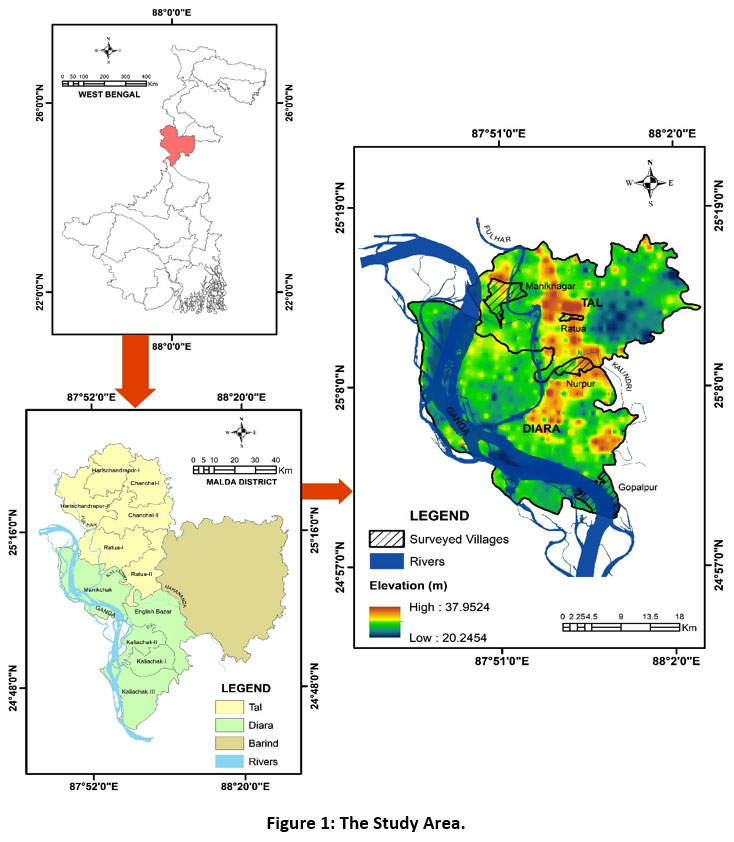 |
Figure 1: The Study Area. Click here to view Figure |
Malda has three distinct physiographic units (Fig. 1), viz. Barind, consisting of lateritic or older alluvial having remnants of an older flood plain, covering a relatively elevated ground and less prone to floods13. Next is Tal, a marshy tract mainly made up of older alluvium, bog lands found as pockets in the flood plains along diminishing inland drainages, prone to floods during the rainy season25. The Tal gradually slopes towards the south-west and merges with the next physiographic unit, i.e., Diara. The 'Diara', as the name implies, bounded by rivers, is a well-drained flatland created by younger alluvium having an elevation of less than 27 meters above M.S.L. Alluvium deposits are enriched annually by flood, rendering it highly fertile, making it suitable for agriculture and related livelihoods26. Both Tal and Diara are heavily settled despite being vulnerable to floods, suggesting that the residents here have learned to cope with floods, implying a higher degree of resilience. This paper, therefore, discusses the coping and adaptive strategies embraced by the people living in Tal and Diara regions of Malda district.
Materials and Methods
Data Source
This article is empirical in nature. Primary data has been collected through field investigation, conducted from September to October 2018, from the two sets of villages. One set of villages located near the River Fulhar i.e., Maniknagar in Tal and the River Ganga i.e., Gopalpur in Diara, and the other set of villages i.e., Ratua in Tal and Nurpur in Diara located at a distance from the respective rivers (Fig. 1).
Primary data has been collected at two levels- focus group discussion with village elders, helped in understanding the overall flood situation in both sets of villages and its impact on the loss of livelihoods, settlements, infrastructure, life, and livestock in general, with an emphasis on the most recent major flood event of August 2017. Information on selected indicators, suggesting the villagers' pro-action and resilience to combat flood risk by their level of preparedness to cope with and adapt to the adversaries associated with the flood event of 2017 has been gathered by stratified household survey, conducted with the help of semi-structured schedule, in the selected sets of villages.
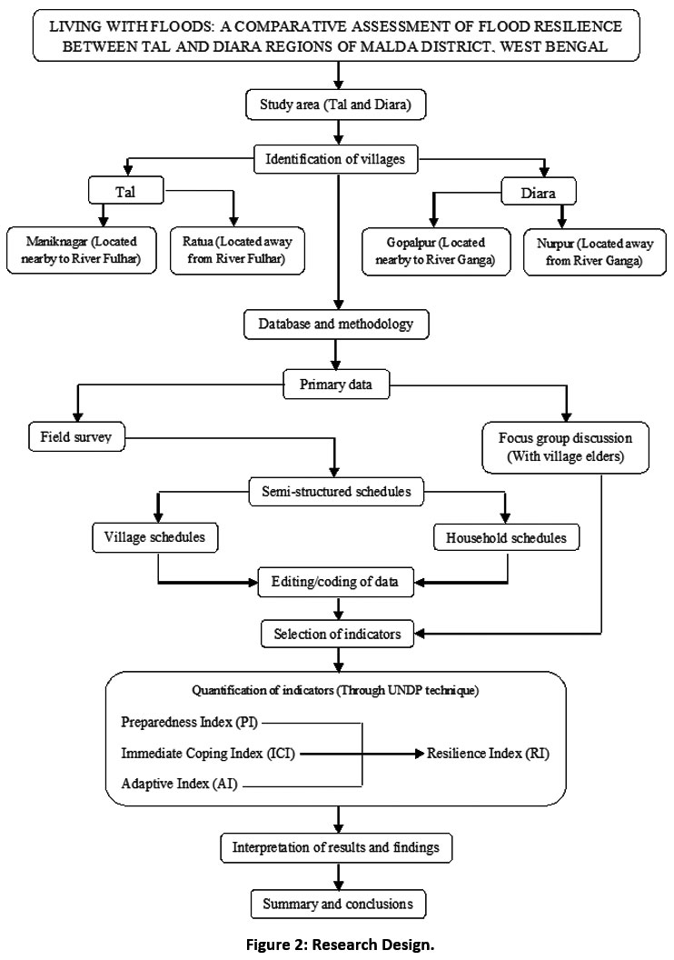 |
Figure 2: Research Design. Click here to view Figure |
Sample Size
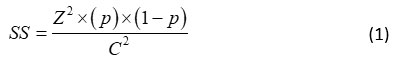
Since the villages surveyed have large number of households, a total of 712 households have been surveyed in the two sets of villages (Table 1). The sample households were determined using an online resource, i.e., sample size calculator by Creative Research Systems27 (https://www.surveysystem.com/sscalc.htm), which follows the equations developed by Cochran28. Following formula has been used to select the number of households to be surveyed in each village (Eq.1):
Where, SS denotes sample size; Z refers to standard score corresponding to a given confidence level (e.g., 1.96 for 95% confidence level); p is the percentage picking a choice (estimated proportion of an attribute that is present in the population), expressed as a decimal (e.g., 0.5 used for sample size needed) and C is the confidence interval, expressed as decimal (e.g., 0.04 = ±4).
Correction for Finite Population
Since obtaining sample size from Eq. (1), it is necessary to adjust this according to the finite population to provide proportionately more information for given population size, and the following is the formula used for correction28 (Eq. 2):
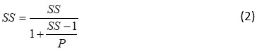
Where, P is the Population
Table 1: Sampling Framework.
|
Regions |
C.D. blocks |
Villages |
Total households |
Sample households |
Confidence level |
Confidence interval** |
|
|
Tal |
Ratua-I |
Maniknagar |
1880 |
178 |
95% |
7 |
|
|
Ratua |
1224 |
170 |
95% |
7 |
|||
|
Diara |
Manikchak |
Gopalpur |
2010 |
180 |
95% |
7 |
|
|
Nurpur |
2933 |
184 |
95% |
7 |
|||
|
Total |
|
|
8047 |
712 |
|
|
|
** ±7 is the margin of error. Note: sample households have been drawn from an online resource, i.e., sample size calculator by Creative Research Systems (https://www.surveysystem.com/sscalc.htm), which follows the equations developed by Cochran28.
Techniques and Analysis
A stratified random sampling technique was used to conduct the household survey in both sets of villages. Information on selected 21 indicators suggesting the preparedness, immediate coping, and long-term adaptive strategies to combat flood menace has been obtained from each household, quantified and measured by Preparedness Index (PI), Immediate Coping Index (ICI), and Adaptive Index (AI). Afterward, the composite Resilience Index (RI) derived from PI, ICI, and AI has been computed to determine the degree of resilience to floods at micro level in the two sets of villages of Tal and Diara. The score indices were developed using the UNDP29 technique. The scores range from 0 to 1, where the higher the score the higher is the preparedness, coping, and adaptive strategies of households. The formula for constructing the indices29 (Eq. 3):

Where, PIV denotes Preparedness Index, ICIV denotes Immediate Coping Index, AIv denotes Adaptive Index for representative village v ; Xiv is the actual value of ith variable for representative village v ; Amax is the maximum value of ith variable for representative village v and Amin is the minimum value of ith variable for representative village v.
Results and Discussion
Preparedness Strategies
Adequate preparedness can significantly improve the response to any hazard30,31. Six indicators suggesting the level of preparedness indicate that within Tal and Diara, the surveyed villages located near the rivers Fulhar and Ganga, viz. Maniknagar and Gopalpur show substantially higher levels of preparedness strategies to mitigate flood menace compared to the interior set of villages located at a distance from the rivers Fulhar and Ganga, viz. Ratua and Nurpur, respectively (Fig. 3).
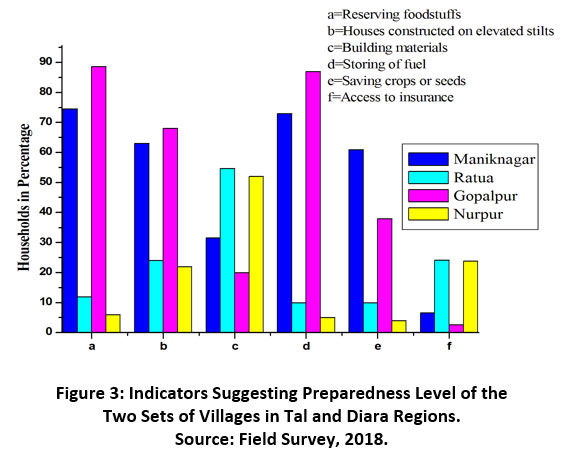 |
Figure 3: Indicators Suggesting Preparedness Level of the Two Sets of Villages in Tal and Diara Regions. Source: Field Survey, 2018. Click here to view Figure |
Reserving food items is the most common strategy that households follow to survive the crisis like floods. It is worth noting that 88.6% of the respondents of Gopalpur in Diara and 74.5% of the respondents of Maniknagar in Tal, tend to reserve food stocks, especially dry foodstuffs such as Chire (flattened rice), Gur (jaggery), Chatu, Muri (puff rice), Atta (flour), etc. to meet their immediate hunger during the flood season, which is not the case in the interior villages of Ratua and Nurpur (Fig. 3). Gopalpur and Maniknagar are both located in low-lying areas close to the river banks (Fig. 1). The embankment is often breached during periods of heavy rainfall, leading to floods. The riverside villagers are well prepared for this eventuality as they have built their settlements on stilts. Field investigation suggests about 68% of houses in Gopalpur and 63% of houses in Maniknagar are built on stilts, at an average height of 5 feet above the ground, allowing free flow of floodwater. In contrast, in the interior villages of Ratua and Nurpur, less than a quarter of the houses are built on stilts (Fig. 3). The type of building materials used also has an impact on the ability of a structure to withstand floodwaters9. Concrete structures are typically resistant to floodwaters. Field investigation reveals that the riverside villages of both the physiographic units, viz. Maniknagar and Gopalpur have almost 50% of their population living in Kutcha houses, which are highly vulnerable to flood. This can be attributed to the fact that the riverside villages report a higher incidence of poverty in comparison to the interior villages of Ratua and Nurpur, where more than half of the households live in concrete houses that are more resistant to flood (Fig. 3).
The storing of fuel for hazard-related crises is also a significant preparedness strategy embraced by the hazard-prone community at the household level32. Field data indicate that a higher percentage of respondents living in Gopalpur (87%) and Maniknagar (73%) store fuel materials such as Ghute (cow dung mold), jute sticks, and kerosene oil, etc. to meet their fuel demand at the time of crises, compared to the interior villages of Ratua and Nurpur (Fig. 3). Similarly saving of crops or seeds for future agricultural use after the floods recede is one of the key preparedness strategies used by farmers in the selected villages. Field data suggest that 61% of respondents in Maniknagar save their crops and seeds compared to 38% of Gopalpur respondents who report the same (Fig. 3). This can be attributed to the fact that Maniknagar is mainly an agricultural village where most households are engaged in farming. Whereas Gopalpur suffers from severe bank erosion and rich fertile land is being rapidly eroded, the villagers here report a shift in their main livelihood practices. In contrast, the interior villages of Ratua and Nurpur, which are less affected by floods, exhibit less preparedness in this aspect, with just 10% and 4% of respondents reporting saving crops or seeds to fulfil future agricultural requirements, respectively.
Vincent9 considers that insurance coverage is an important preparedness to fight flood threats. Unfortunately, field data displays that in both the riverside villages, viz. Maniknagar and Gopalpur, less than 10% of their respondents, have insurance coverage, mainly life insurance of the head of the household (Fig. 3). Crop, livestock, and home/property insurances are unheard of in these two villages, despite the fact that almost every year they are at the mercy of rivers that leads to life, livelihood, and property loss. The poor share of access to insurance coverage in these villages can be attributed to the impoverished condition of the villagers, where every flood occurrence drives them deeper into the vicious cycle of poverty. As a result, villagers do not have enough funds to pay for the insurance policies. By comparison, almost a quarter of the respondents living in Ratua (24.1%) and Nurpur (23.78%) say that they enjoy some sort of insurance (Fig. 3).
Coping Strategies
A community that builds safe coping mechanisms tends to be more resilient to any catastrophe33,34. Seven indicators have been used for this study to determine the coping strategies of the two sets of villages in Tal and Diara. According to field data, the villagers of Maniknagar and Gopalpur have evolved better immediate coping strategies than the interior villages of Ratua in Tal and Nurpur in Diara (Fig. 4).
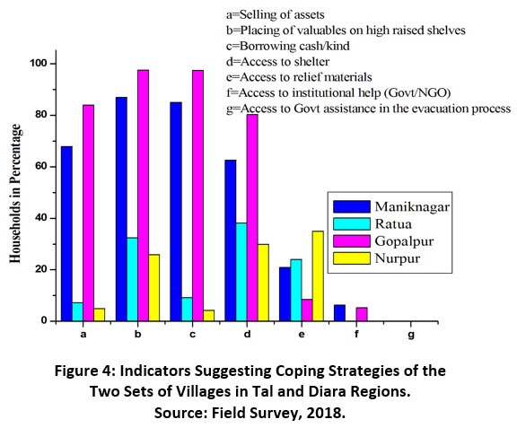 |
Figure 4: Indicators Suggesting Coping Strategies of the Two Sets of Villages in Tal and Diara Regions. Source: Field Survey, 2018. Click here to view Figure |
During a flood catastrophe, households often respond to the acute shock by reducing household expenditure and selling assets35. Assets such as livestock, furniture, television, cell phones, bicycles, farm or fishing equipment, and even sometimes land are essentially sold by households to augment their income during and after the floods have receded. Field data suggest that selling or mortgaging household assets has emerged as one of the most reactive immediate coping mechanisms in the absence of any institutional assistance for the first set of villages located near the river banks. It is worth mentioning that the sale of assets is more prevalent in Gopalpur, where 84% of respondents sell their assets immediately to cope with flood situations, compared to the respondents of Maniknagar (68% of respondents) (Fig. 4). This can be attributed to the fact that Gopalpur is more affected by erosion and land loss due to floods and associated bank erosion and has a higher rate of poverty compared to Maniknagar20. The interior villages of Ratua in Tal and Nurpur in Diara record an insignificant number of respondents (less than 10%) selling their assets or mortgaging their land and other resources to fulfil their immediate needs during the last flood event of August 2017 (Fig. 4).
In flood-prone areas, rural residents often put their valuables, such as important papers, food, and other items on high-rise shelves in their homes to protect them from floodwaters. It is important to note that in both the villages of Gopalpur (97.56%) and Maniknagar (87%), a very high proportion of respondents, choose to put their valuables wrapped in plastic sheets, on high-rise shelves, particularly during the free flow of floodwater resulting in ground-level submergence of settlements. On the contrary, in the interior villages, field data suggest that less than half of the respondents of Ratua and slightly above a quarter of the respondents of Nurpur report that they keep their valuables on high-rise shelves (Fig. 4). As survival prospects get exceedingly restricted during flood incidents, economically marginalised households with almost no savings often recourse to borrowing cash to cope with the immediate crisis36,37. Figure 4 indicates that 92% of respondents from Gopalpur and 81% of respondents from Maniknagar borrowed money from their neighbours or money lenders at high interest rates, during the last major flood event of 2017. In the interior villages of Ratua and Nurpur, a limited number of respondents reported borrowing money during the last flood of 2017.
As floodwaters destroy and damage settlements, livestock, and other properties, including life loss, the affected population is forced to flee to safer locations (on embankments, roads, rail lines, community flood shelters, and other higher grounds) with their valuables and livestock. Figure 4 indicates that more than 80% respondents of Gopalpur were forced to leave their homes along with their livestock and valuables during the last major flood event of 2017. In Maniknagar, more than 60% of the respondents reported being forced to leave their homes. The higher proportion of respondents who reported leaving their hearth to seek shelter elsewhere in Gopalpur can be attributed to the fact that this village, as already stated is experiencing riverbank erosion by River Ganga, which became more pronounced during the 2017 flood event, displacing a larger segment of the population homeless and landless compared to Maniknagar. In contrast, Ratua and Nurpur were both partially affected by the big flood event of 2017. Consequently, more than a quarter of the households in both the villages moved out of their respective homes and took refuge in the school buildings situated in their respective villages (Fig. 4). During any major flood event, access to relief materials is considered as an essential indicator suggesting coping strategy of the flood affected people38,39. Unfortunately, access to relief materials from external agencies during the big flood event of August 2017 was nominal in both the sets of villages in Tal and Diara. Interestingly, only 21% of respondents from Maniknagar and 8.58% of respondents from Gopalpur stated that they had received some form of flood relief (dry food items, clothing, medicines, etc.) from Government agencies during the last flood event in 2017, despite the fact that both of these villages were seriously affected by the flood hazards (Fig. 4). In the absence of institutional assistance, the community has developed its own coping strategies to counter the danger of floods, as the villagers believe in sharing their food and other resources.
Adaptive Strategies
‘Adaptation’ refers primarily to long-term strategies while ‘coping’ to short-term or mid-term adjustments in order to minimise the detrimental effects of a hazard40. The adaptive strategies of the villagers living in the two sets of villages were evaluated and compared using eight indicators. It is worth noting that the respondents from Maniknagar and Gopalpur reported comparatively higher adaptation strategies compared to the interior villages of Ratua and Nurpur (Fig. 5).
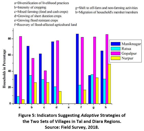 |
Figure 5: Indicators Suggesting Adaptive Strategies of the Two Sets of Villages in Tal and Diara Regions. Source: Field Survey, 2018. Click here to view Figure |
Since loss of major livelihood practices is an inevitable consequence of flood hazards, changes in livelihoods and diversification of livelihoods are common activities for households in flood-prone areas41. Figure 5 indicates that in Gopalpur, 83% of respondents stated that they have increased their sources of income by diversifying their livelihood practices. A significant portion of the households in this village stated that they have lost their farmland due to riverbank erosion and are now agricultural labourers employed in neighbouring villages, doing odd jobs to support their families. In Maniknagar, 36% of respondents stated they lost their major livelihood practice after the last flood of 2017 and have diversified their livelihood practices to support their families. The soft clay deposited in and around the riverbank is suitable for brick making, which has a high demand in the market; hence, the brick kilns are growing in and around the riverside villages, the villagers here find employment in these brick kilns resulting in diversification of livelihood practices. Conversely, the interior villages of Ratua and Nurpur record fewer households registering changes in their major livelihood practices and less diversification of livelihood practices (Fig. 5).
Multi-cropping practice leading to increase in crop intensity helps farm households become more resilient to flood threats, as it increases agricultural productivity and minimises losses from crop failure due to floods42,43. Field data indicate that in Maniknagar, 71% of farm households record multi-cropping with crops having different agricultural calendars, increasing agricultural intensity and production. More land is allocated to long stem rain-fed Aman rice and jute that grow with floodwaters in the Kharif season in the riverside villages. Among the Rabi crops grown are vegetables, mustard, and pulses, whose productivity is high, taking advantage of soil moisture and the regeneration of the rich alluvium provided annually by the floods. In Gopalpur, where arable land is reduced due to bank erosion, 56% of farm households, are also engaged in multi-cropping (Fig. 5). In the interior villages of Ratua and Nurpur, where the land is occasionally inundated long stem rice is preferred, more land is provided to jute, and pisciculture is also popular. Surprisingly, in both physiographic units, farmers have little knowledge of the latest flood-resistant crops, suggesting that there is a low level of awareness and fewer institutional interventions with farmers to boost agriculture/
Mixed farming (food and cash crops) has emerged as one of the ways to minimise losses from crop failure due to the risk of flooding, especially in the case of Kharif or monsoon crops39. In the villages of Gopalpur and Maniknagar, the marginal and small farmers cultivate jute, vegetables, mustard, pulses, etc., as cash crops along with a small amount of paddy for self-sustenance (Fig. 5). Interestingly, in the interior villages, viz. Ratua in Tal and Nurpur in Diara, farmers are mainly growing paddy and jute with less crop diversification as compared to the villages near the rivers. In the villages of Maniknagar and Gopalpur, most farmers prefer to grow short-duration crops that are harvested before floods, e.g., Aus rice sown in March-April and harvested in July is common. Crops like sugarcane, and maize, which require a longer time to mature are avoided and farmers here grow short-duration Rabi crops e.g., vegetables, wheat, Boro paddy, mustard, and pulses more intensively. Figure 5 indicates the majority of farm households in Maniknagar (76.52%) and Gopalpur (77.82%) report that they are growing short-duration crops. Conversely, an insignificant number of agricultural households in the interior villages of Ratua and Nurpur record the same, as these villages are less affected by floods.
Field investigations reveal that after the floodwater recedes, the farmers reclaim their cropland by cleaning up the weeds and leaving the land fallow for at least two three months. Then they plough and sow Kalai, Musur, Khesari (types of pulses), tomatoes, etc. to revive the soil's fertility. These pulses and vegetables do not require much labour or fertiliser; on the contrary, these crops fertilize farmland from being depleted to wasteland. Field data suggest that more than 80% of respondents from Maniknagar and Gopalpur adopted this method to tackle the problem of wasteland brought by the onslaught of floods (Fig. 5). It should be noted that following a big flood, the soil is replenished, enhancing soil fertility and resulting in bumper crop production.
Field surveys indicate that off-farm and non-farm activities are emerging as one of the major adaptive strategies pursued in the villages of Diara, especially in Gopalpur, where 82.33% of agricultural households have shifted to off-farm activities such as mango orchards, sericulture, pisciculture, and non-farm activities such as wage labour in brickfields and construction sites, petty business, and other odd jobs (Fig. 5). Strikingly in Gopalpur, there is a higher number of respondents reporting a change from agricultural practices to non-farming activities as this village reports higher cropland loss due to riverbank erosion. In Maniknagar, more than a quarter of respondents (35%) registered a change from farm activities to off-farm and non-farming activities. In the interior village of Nurpur in Diara, just 32% of respondents report shifting from farm activities to non-farm and off-farm activities. However, the village of Ratua in Tal has a higher proportion of respondents (36%) shifting to off-farm practices like horticulture, mainly mango and litchi orchards, inland water fish farming, and sericulture (Fig. 5).
Out-migration of a family member/members who remit cash/kind at home at regular intervals emerges as an inevitable pro-active, adaptive strategy to counteract the threat of floods21,23,44. Malda is no exception to this, and field investigation suggests that about 85% of respondents of Gopalpur stated that they have sent a member/members from their families outside their village/district/state in search of better livelihood options compared to 65.2% of respondents of Maniknagar who conveyed the same. Most villagers prefer to go to other states like Delhi, Mumbai, Bangalore, and Kerala in search of better livelihood opportunities. These migrant workers remit cash/kind to their families, which contributes to the family income. In contrast, the interior villages of Ratua and Nurpur record a comparatively lesser incidence of migration of family member/members to another state in search of employment (Fig. 5).
Resilience to Flood Hazards: Preparedness Index (PI), Immediate Coping Index (ICI), Adaptive Index (AI), and Resilience Index (RI)
It is important to note that, in the final assessment, the coping and adaptive strategies developed by villagers at the household level are just about the same for both the physiographic units, viz. Tal (0.36) and Diara (0.37) with slightly higher flood resilience for the Diara population, which is indeed more vulnerable to floods and bank erosion (Fig. 6). It should be noted that studies suggest that the River Ganga is shifting its course in and around this area15,17-20.
The distance factor from the major rivers of Fulhar in Tal and Ganga in Diara tends to play a role in the level of resilience to flood hazards (Fig. 6). The villages located near the banks of the rivers Ganga and Fulhar record a higher degree of resilience to floods (0.56 for Gopalpur and 0.51 for Maniknagar) compared to the interior villages of Ratua (0.20) located at a distance of about 4 km from the River Fulhar and Nurpur (0.18) placed at a distance of about 14 km from the River Ganga, the major flood producing rivers of Tal and Diara respectively. This can be due to the fact that the villages situated near the banks of the rivers are more exposed to flood hazards, rendering the population more vulnerable to flood when compared to the interior villages of Ratua and Nurpur. As a result, villagers living in Maniknagar and Gopalpur are more pro-active and better prepared to deal with floods, as evidenced by higher scores in the Preparedness Index (PI), Immediate Coping Index (ICI), and Adaptive Index (AI) in comparison to the interior villages (Fig. 6). Interestingly, in both the physiographic units of Tal and Diara, the villagers have developed better risk management to flood hazards and have adapted an optimal farming system, making Malda district populous.
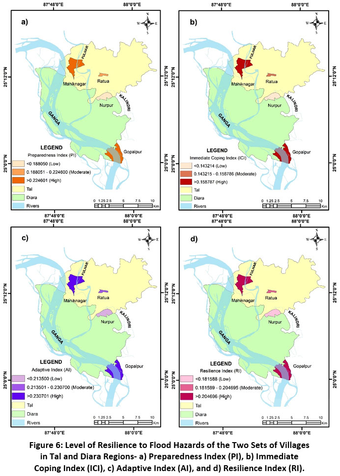 |
Figure 6: Level of Resilience to Flood Hazards of the Two Sets of Villages in Tal and Diara Regions- a) Preparedness Index (PI), b) Immediate Coping Index (ICI), c) Adaptive Index (AI), and d) Resilience Index (RI). Source: Field Survey, 2018. Click here to view Figure |
Conclusion
The geographical location of the Malda district, along with its geomorphology, makes it extremely prone to floods, especially in the low-lying Tal and Diara regions. Despite annual floods that adversely impact people’s lives and livelihoods, the Tal and Diara regions of Malda support higher population density than the state’s average density. This reflects that the people living here have learned to live with floods since they have built a greater degree of resilience to flood hazards, thereby, reducing their vulnerability. The present article suggests that Maniknagar and Gopalpur villages, located close to major flood-producing rivers, viz. Fulhar in Tal and Ganga in Diara, have evolved stronger coping and adaptation strategies to floods than the interior villages of Nurpur and Ratua.
It is worth mentioning that people prefer to stay in Tal and Diara amid flood rage, as with every flood event, the soil becomes enriched, contributing to the higher production of crops and vegetables. People have learned to live with floods in order to reap the benefits of floods. In a broader sense, while assessing vulnerability to any hazard, it is necessary to assess the coping and adaptive strategies that are linked to resilience at the individual/household/community level. This holistic approach to disaster mitigation not only leads to improved risk management but also checks vulnerability of an individual/household/community, as the higher the degree of resilience of the people, the lesser is their degree of vulnerability to any hazard, including floods. It is in this context, this article analyses and discusses the degree of preparedness, coping, and adaptive strategies of people at the household level, leading to better risk reduction at the micro level to minimise vulnerability and build a disaster-resilient society. Hence, policymakers and stakeholders may collaborate to build a more resilient society, reducing susceptibility to events like floods by spearheading similar research in analogous regions of the world that are prone to flood hazards.
Acknowledgement
We would like to place on record our thanks to the respondents from the surveyed villages for volunteering to give necessary information on which this article is based. We also place on record our sincere gratitude to the Government officials and NGOs for their kind co-operation. In addition, we would like to express our sincere thanks to the constructive comments and feedback of the anonymous reviewers for improving the clarity and quality of this paper.
Funding Source
There is no funding or financial support for this research work.
Conflict of Interest
The authors have no conflicts of interest to declare that are relevant to the content of this article.
References
- Chari PR. India and Natural Disasters. In: Marquina A, ed. Global Warming and Climate Change: Prospects and Policies in Asia and Europe. Palgrave Macmillan, London; 2010:145-158. https://doi.org/10.1057/9780230281257_9.
CrossRef - Intergovernmental Panel for Climate Change (IPCC). Climate Change, 2001, Synthesis Report: A Contribution of Working Groups I, II and III to the Third Assessment Report of the Intergovernmental Panel on Climate Change. New York: Cambridge University Press; 2001.
- United Nations. Hyogo Framework for Action 2005-2015: Building the Resilience of Nations and Communities to Disasters. Paper presented at: World Conference on Disaster Reduction; January 18-22, 2005. Kobe, Hyogo.
- Keogh DU, Apan A, Mushtaq S, King D, Thomas M. Resilience, vulnerability and adaptive capacity of an inland rural town prone to flooding: a climate change adaptation case study of Charleville, Queensland, Australia. Natural Hazards. 2011;59(2):699-723. https://doi.org/10.1007/s11069-011-9791-y.
CrossRef - Balica SF, Wright NG, van der Meulen F. A flood vulnerability index for coastal cities and its use in assessing climate change impacts. Natural Hazards. 2012;64(1):73-105. https://doi.org/10.1007/s11069-012-0234-1.
CrossRef - Nguyen KV, James H. Measuring household resilience to floods: a case study in the Vietnamese Mekong River Delta. Ecology and Society. 2013;18(3).
CrossRef - Ibeje AO, Ekwueme BN. Regional Flood Frequency Analysis using Dimensionless Index Flood Method. Civil Engineering Journal. 2020;6(12):2425-2436. doi:10.28991/cej-2020-03091627.
CrossRef - Latif S, Mustafa F. Parametric Vine Copula Construction for Flood Analysis for Kelantan River Basin in Malaysia. Civil Engineering Journal. 2020;6(8):1470-1491. doi:10.28991/cej-2020-03091561.
CrossRef - Vincent K. Uncertainty in adaptive capacity and the importance of scale. Global Environmental Change. 2007;17(1):12-24.
CrossRef - Birkmann J, Cardona OD, Carreño ML, Barbat AH, Pelling M, Schneiderbauer S, Kienberger S, Keiler M, Alexander D, Zeil P, Welle T. Framing vulnerability, risk and societal responses: the MOVE framework. Natural Hazards. 2013;67(2):193-211. https://doi.org/10.1007/s11069-013-0558-5.
CrossRef - Birkmann J. Measuring vulnerability to promote disaster-resilient societies: Conceptual frameworks and definitions. In: Measuring vulnerability to natural hazards: Towards disaster resilient societies. Tokyo: United Nations University Press; 2006:3-7.
- Bohle HG. Vulnerability and Criticality: Perspectives from Social Geography. IHDP Update. Newsletter of the International Human Dimensions Programme on Global Environmental Change. 2001:1-7.
- Laha C. Changing course of the river Ganga in Malda district West Bengal-Damage assessment and risk zone management. [PhD thesis]. 2015.
- Bandyopadhyay S. Evolution of the Ganga Brahmaputra delta: a review. Geographical review of India. 2007;69(3):235-268.
- Rudra K. Flood in the GBM Delta. In: Rivers of the Ganga-Brahmaputra-Meghna Delta. Switzerland: Springer International Publishing; 2018:125-136.
CrossRef - Disaster Management Department, Government of West Bengal. District Disaster Management Plan of Malda. WBDMD; 2017.
- Ghosh A, Kar SK. Application of analytical hierarchy process (AHP) for flood risk assessment: a case study in Malda district of West Bengal, India. Natural Hazards. 2018;94(1):349-368. https://doi.org/10.1007/s11069-018-3392-y.
CrossRef - Parua PK. Erosion problems of the river Ganga in the districts of Malda and Murshidabad in West Bengal. Civil Engineering Today, ASCE: Calcutta. 1999;13(2):3-20.
- Parua PK. Farakka barrage-a multi-purpose project with dispute. Indian Journal of Power and River Valley Development. 2002;52(11/12):248-260.
- Rudra K. Living on the edge: the experience along the bank of the Ganga in Malda district, West Bengal. Indian Journal of Geography & Environment. 2000;5:57-67.
- Bannerjee M. A report on the impact of Farakka barrage on the human fabric. New Delhi: South Asian Network on Dams, Rivers and People (SANDRP); 1999.
- Sengupta N. World commission on dams: Biased if misread. Economic and Political Weekly. 2001;36(19):1647-1649.
- Iqbal S. Flood and erosion induced population displacements: a socio-economic case study in the Gangetic riverine tract at Malda district, West Bengal, India. Journal of Human Ecology. 2010;30(3):201-211.
CrossRef - Thakur PK, Laha C, Aggarwal SP. River bank erosion hazard study of river Ganga, upstream of Farakka barrage using remote sensing and GIS. Natural Hazards. 2012;61(3):967-987. https://doi.org/10.1007/s11069-011-9944-z.
CrossRef - Sahana M, Ahmed R, Hossain N, Sajjad H. Assessing flood inundation extent and landscape vulnerability to flood using geospatial technology: a study of Malda district of West Bengal, India. Forum Geografic. 2015;14(2):156-163. https://doi.org/10.5775/fg.2067-4635.2015.144.d.
CrossRef - Mukherjee K, Pal S. Channel migration zone mapping of the River Ganga in the Diara surrounding region of Eastern India. Environment, development and sustainability. 2018;20(5):2181-2203.
CrossRef - Creative Research Systems. https://www.surveysystem.com/sscalc.htm. Accessed December 26, 2019.
- Cochran WG. Sampling Techniques. 2nd Ed. New York: John Wiley and Sons; 1963.
- United Nations Development Programme (UNDP). Human Development Report. Oxford University Press; 2000.
- UN/ISDR, International Strategy for Disaster Reduction. Living with Risk: A Global Review of Disaster Reduction Initiatives. UN Publications; 2004.
- Altay N, Green III WG. OR/MS research in disaster operations management. European journal of operational research. 2006;175(1):475-493.
CrossRef - Shafie H, Rahman S. Traditional coping strategies of rural people living in flood-prone areas in North-West Bangladesh. Dhaka: Rangpur Dinajpur Rural Service (RDRS); 2009.
- Smit B, Wandel J. Adaptation, adaptive capacity and vulnerability. Global environmental change. 2006;16(3):282-292.
CrossRef - Nelson DR, Adger WN, Brown K. Adaptation to environmental change: contributions of a resilience framework. Annual Review of Environmental Resources. 2007;32:395-419.
CrossRef - Dewan TH. Societal impacts and vulnerability to floods in Bangladesh and Nepal. Weather and Climate Extremes. 2015;7:36-42.
CrossRef - Aßheuer T, Thiele-Eich I, Braun B. Coping with the impacts of severe flood events in Dhaka's slums—the role of social capital. Erdkunde. 2013:21-35.
CrossRef - Ninno CD, Dorosh PA, Smith LC, Roy DK. The 1998 Floods in Bangladesh Disaster Impacts: Household Coping Strategies, and Response. Washington DC: International Food Policy Research Institute; 2001.
- Okayo J, Odera P, Omuterema S. Socio-economic characteristics of the community that determine ability to uptake precautionary measures to mitigate flood disaster in Kano Plains, Kisumu County, Kenya. Geoenvironmental Disasters. 2015;2(1):26. https://doi.org/10.1186/s40677-015-0034-5.
CrossRef - Banerjee S, Kniveton D, Black R, Bisht S, Das PJ, Mahapatra B, Tuladhar S. Do financial remittances build household level adaptive capacity? A case study of the flood affected households of Upper Assam in India. KNOMAD; 2017.
- Braun B, Aßheuer T. Floods in megacity environments: vulnerability and coping strategies of slum dwellers in Dhaka/Bangladesh. Natural hazards. 2011;58(2):771-787.
CrossRef - Bhuiyan MAH, Islam SMDU, Azam G. Exploring impacts and livelihood vulnerability of riverbank erosion hazard among rural household along the river Padma of Bangladesh. Environmental Systems Research. 2017;6(1):25. https://doi.org/10.1186/s40068-017-0102-9.
CrossRef - Banerjee L. Effects of flood on agricultural productivity in Bangladesh. Oxford Development Studies. 2010;38(3):339-356.
CrossRef - Das M. Socio economic and demographic consequences of river bank erosion in Majuli Island Assam. [PhD thesis]. 2013.
- Development and Planning Department, Government of West Bengal. District Human Development Report: Malda. HDRCC; 2007.


