Forest Land Encroachment in Kehmil Forest Division of Kupwara District: Dimensions, Causes and Consequences
Sajjad Ahmad Khan
*
 , Rayees Afzal Mir
, Syed Aasif Hussain Andrabi
and Mohd Gulfishan
, Rayees Afzal Mir
, Syed Aasif Hussain Andrabi
and Mohd Gulfishan
1
School of Agricultural Science,
Glocal University,
Saharanpur,
Uttar Pradesh
India
http://dx.doi.org/10.12944/CWE.17.2.12
Copy the following to cite this article:
Khan S. A, Mir R. A, Andrabi S. A. H, Gulfishan M. Forest Land Encroachment in Kehmil Forest Division of Kupwara District: Dimensions, Causes and Consequences. Curr World Environ 2022;17(2). DOI:http://dx.doi.org/10.12944/CWE.17.2.12
Copy the following to cite this URL:
Khan S. A, Mir R. A, Andrabi S. A. H, Gulfishan M. Forest Land Encroachment in Kehmil Forest Division of Kupwara District: Dimensions, Causes and Consequences. Curr World Environ 2022;17(2).
Download article (pdf)
Citation Manager
Publish History

Introduction
The survival of forests, which are essential habitats on the earth's surface, allows for the preservation of the variety of flora and fauna. Forests now continuously turned into agricultural and settlement areas. These varied forests are complex habitats made up of both plants and animals. Within a predetermined set of environmental circumstances the ordinary changes has experienced to most species within these habitats. The rural communities extract timber and firewood adjacent to the forest, obtain construction materials, get medicinal plants, collect honey and also graze their livestock in the forest. Generally humans engages in incursion by using forest land for cultivation of crop plants by eliminating forest products like unlawfully utilised timber or non-timber that is not authorised by the government1. The forest invasion is caused by a number of things such as forest area under easy accessibility, poverty, underprivileged education level, unemployment and shortage of staff to check the area and fertility of the soil. The forest degradation has already resulted to a reduction of wildlife habitat and pastoralist livelihoods downstream. Studying land use and land cover change is now essential to understanding how humans and the environment interact2 - 4. Disaster reduction (DDR) and climate change adaptation strategies are similar to those of reducing land use and land cover change (LULCC)5 6. Variations in land use and land cover are related to changes in surface temperature and precipitation7. In Kupwara region the changes in land use and land cover results as a consequence of rise in population, financial growth and changes in many other environmental and social activities8. India with its great topography and climatic diversity has a very rich and diverse flora and fauna9. With the increasing biotic pressure the forests and alpines are getting degraded with the increasing biotic pressure and in the process ground flora and shrubs which happen to deliver bulk of the medicinal plants are also under stress10. Various anthropogenic activities in Kashmir Himalaya including overgrazing, deforestation, rigorous farming, and upsurge in globalization11. The tree species with high density in the study area are Abies pindrow, Pinus wallichiana and Cedrus deodara while as in case of shrubs the dominant species are Parrotiopsis jacquemontiana, Viburnum grandiflorum and Berberis lyceum; in case of herbs species such as Poa spp, Fragaria nubicola,Senecio chrysanthemoides, Ranunculus laetus, Artemisia absinthium and Sambucus wightiana are dominant12. It also observed that due to population explosion, the loss of vegetation is causing land habitats to be used for agriculture at a very rapid rate13.
Materials and Method
Study area
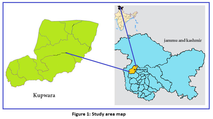
District Kupwara's Kehmil Forest Division is situated at 34.5262° N and 74.2546° E in northern Jammu & Kashmir (Fig 1). Kupwara is regarded as the Kashmir valley's least developed border region. The district is noteworthy for its favourable climate, tourism, and wildlife because it is surrounded by steep mountains and predominantly dense and moderately dense forest areas. Kupwara experiences warm and temperate climate and having pleasant weather from April to October. Snowfall is limited between Decembers to April with insufficient rainfall. The annual average temperature recorded is 14.10°C and average rainfall is 843mm14. The area is biodiversity rich, with dense forests (Himalayan dry-temperate to subalpine forest types) 11
 | Figure 1: Study area map
|
Data collection
The Kehmil forest division of district Kupwara was divided into four ranges; Rahmal, Nahhari, Keran and Karnah with 62472 Hectare of land. The sampling was grouped into two main portions; such as
(a) The area for sample for research and
(b) The population for sample.
34 beats of the study area, 13 beats that were sampled in this research which were surveyed at two different time periods. The purpose of this sampling depends the following:
(a) The part is integrated in Kehmil forest division,
(b) the region that interacts on a social and economic level with the forest
(c) The sample part is very close to the forest and
(d) The region is part of an area where the forest has encroached.
Moreover, the data necessary for this research has also been collected through interviews of the local community, onsite observations and available literature and documentation.
The first survey
It was conducted during September 2020 to November 2020. FSI's (Forest Survey of India) land-use and land-cover map from 2019 served as the foundation for the test dataset survey as a reference and material object, also during the field work, GPS (Global Positioning System) was used to find out the different positions. Additionally, to record the fieldwork a digital camera was also used. This first beat survey in which six beats were selected was done to identify the types of incursion occurred and the way people intrude into forest for their living. The individual participatory rural assessment recognized the key living activities of inhabitants under six specific beat as (a) maize farming, (b) grazing, (c) paddy cultivation and (d) cutting wood for fuel and construction (Fig.2.) .
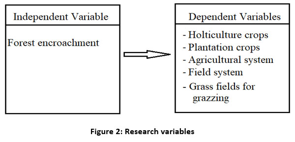 | Figure 2: Research variables.
|
The second survey.
It was conducted between September 2021 and November 2021. This research involved seven beats. Interviews were conducted with the forest department employees of Kehmil forest division based on questionnaires addressing vegetation classification and disturbances.
To gather data from those who relied on the forest for their survival, questionnaires were used. A random sample of 5–40 houses was chosen for each beat. Interviews with the heads of the sampled population were conducted based on a questionnaire that covered the principal economic activities. Cropland areas close to forested areas and cropland around the sample households' villages, socio - economic status, and the agrarian calendar were also largely used.
Data acquisition and analysis
With pre-formulated questionnaire, respondents were interviewed. Through a reconnaissance survey pre-testing was done with questionnaire. For analysis MS EXCEL, SSPL win version 10 has been broadly used.
Result and discussion
Area of encroachment and attributes of forest occupants
Renovating forest services into agriculture, horticulture, or habitations is known as "forest intrusion."1.. The main reason behind the forest encroachment by the population were; (a) Rise in population and unemployment, (b) Limitation of agricultural land and (c) Limitation of forest guards. The number of forest encroachers of area under study was 2178. The data were taken from 34 beats (Table 1). 1381 intruder, on average, have land areas smaller than a hectare which suggest that, to fulfill their needs, most of encroachers in area under study were dependent on agricultural product. Most of the encroachers were in the productive age range, which is defined as being between 18 and 64 years old, but some others were classified as being in the quasi age range, or being older than 64 years old. One of the major contributing causes to encroachment was education level or productive awareness of the area of research. Along with other divisions of district Kupwara, deforestation is a major environmental issue. Over the course of the 21th century, according to GFW (Global Forest Watch), the forest cover of the country has been dropped. The recent high population growth and diverse human activities in the Himalayan temperate zone have resulted in a number of environmental issues. The largest driver of tree cover loss in india since 2000 is logging. In the study area, total number of beat surveyed at different time periods were 34 and the total encroached was 546.89 hectares by 2178 encroachers (Table 1). The majority of plantations inhabited on encroached land areas were (a) maize cultivation, (b) walnut plantation, (c) paddy cultivation, and (d) grass cultivation. As they have few options for a living, the nomadic people who dwell in the pine forests nearby at high altitude rely largely on pine tree species for fuelwood, lumber, and leaf litter. The new settler, for their settlement, take down the trees and it is huge where livestock shepherded already occupied the area15.
Table 1: No of beats with encroachment area in hectare, encroachment cases, and status of encroached land.
S.No | Beat name | Encroached area in hectare | No. Of cases | Status of Encroached land |
1 | Awoora | 47.8 | 96 | The maize cultivation, walnut plantation, paddy cultivation and grass cultivation |
2 | Amroie | 4.5 | 48 | |
3 | Budnambal | 29.08 | 133 | |
4 | Dardpora | 29.75 | 99 | |
5 | Dari | 6.62 | 55 | |
6 | Doodwani | 5.85 | 63 | |
7 | Drangyari | 36.36 | 178 | |
8 | Farkin | 13 | 97 | |
9 | Gabra | 11.78 | 43 | |
10 | Gugloosa | 0.65 | 9 | |
11 | Gulgam | 9.85 | 89 | |
12 | Gushie | 19.35 | 77 | |
13 | Hafrada | 29.4 | 96 | |
14 | Jada | 12.05 | 58 | |
15 | Jumangand | 5.95 | 27 | |
16 | Kachama | 27.01 | 47 | |
17 | Kadama | 4.65 | 24 | |
18 | Keran | 4.8 | 26 | |
19 | Khanbal | 50.09 | 140 | |
20 | Kralpora | 31.07 | 48 | |
21 | Kranu | 8.9 | 38 | |
22 | Kulsari | 2.75 | 17 | |
23 | Laderwan | 9 | 43 | |
24 | Malikpora | 26.95 | 113 | |
25 | Manzgam | 26.01 | 87 | |
26 | Panzgam | 15.6 | 56 | |
27 | Punzwa | 20.18 | 67 | |
28 | Rashanpora | 0.75 | 10 | |
29 | Reddi | 13.45 | 30 | |
30 | Sulaiman | 18.13 | 64 | |
31 | Teetwal | 1.65 | 23 | |
32 | Trehgam | 4 | 54 | |
33 | Zoonareshi | 12.6 | 76 | |
34 | Zurhama | 7.31 | 49 | |
| Total | 546.89 | 2180 |
Changes in the extent of forest vegetation
There were mostly five types of forest in Kupwara district and among them, sub alpine and alpine forest types are dominant throughout the forest specifically in Kehmil forest division which was protected from degradation. Southwest Kehmil division forest blocks had the most variety of vegetation, dominated forest mixture and grassland indicating a long history of encroachment (Fig.3). This degraded part of the forest comprised the area set aside for settlement. There was little encroachment on the western side of the forests in the Kehmil forest division. Due to forest encroachment, the expected ranking of tree species identified in the undisturbed forest was altered. The abolition of species for encroachment in study area were Abies pindrow, Cedrus deodara, Pinus wallichiana, Picea smithiana, Picea morinda, Robinia pseudoacacia. The record from forest department and on ground survey suggests the clearness of forest cover for agricultural purposes. In order to clear the other species inside the encroached forest area were herb species like Fragaria nubicola, Lacaita, Sibbaldia cuneata, and Shrub like Parrotiopsis jacquemontiana, Rehder, Viburnum grandiflorum, Indigofera heterantha. Assumed the interplay among vegetation, climate, anthropogenic impacts, offensive species, and troubled management, a stable structure of vegetation cannot be guaranteed16. The determination of reliable reference conditions is a fundamental problem in ecological restoration17 18, and any restoration strategy must take into account the numerous dangers involved with such large-scale change. Besides this it is observed that at the expense of forest cover the farmland is increasing, therefore, through alternate refined sources, the trend can be checked. A periodical assessment of the forest cover should be done as well as the locals should be engaged with the education of environment and forest so that they could be aware and learn about the changes in forest and its subsequent effects on nature and their lives13.
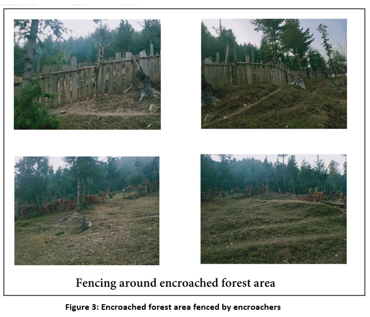 | Figure 3: Encroached forest area fenced by encroachers.
|
Strategy and the framework of law
Legal compliance
The new law of forest19 has clear policies concerning forest excisions that should protect the forests from future excisions and nullify the proposed excisions. Measures should then be taken to reduce any further decrease in the forest land and to initiate proper management plans that will enhance the capacity of the forest to sustain its functions. Although the law prohibits illicit practices in reserved forests, it has been effectively undermined by rising poverty, increased economic activity, and a lack of enforcement there, leading to the continuation of unapproved tree cutting and encroachment for farmland, grassland, and establishment projects. As per the forest law, inside the reserved forest, agricultural engagement activities constitute a violation of the law. Agriculture land expansion committees advocate for the transition of forest land, including forests, into farmland at the national, regional, district, and township levels. Regional authorities give priority to farmers, particularly who live around forest area. To the existing farmers it became accessible to do encroachment more land year by year. The government has not prioritized the conservation of the forest land and forest species, especially compared to its emphasis on agriculture owing to dearth of consciousness about the worth of forest diversity, forest resources, forest communities, forest factors for regulation of climate.
Conclusion
The encroachment area turned into agricultural system of Kehmil forest division was a continuous process from last ten years. Economic and cultural aspects are the encroacher taken into account while establishing the evolved horticulture and farming methods. Due to forest land encroachment, the abolition of forest plant species in study area has altered the expected ranking of tree species identified in the undisturbed forest. This research has contributed to the explanation of the vegetation composition close to the Kehmil Forest Division's encroached forest area and may be used to direct restoration efforts and planning stages for natural ecosystem. Plant types that were planted under encroached area of study were dominated with crops of horticultural and agricultural importance such as Zea mays, capsicum, Solanum lycopersicum, Solanum toberosum and Allium cepa. Other plantation crops are the trees with high value such as Juglans regia, Papulus alba and Salix alba. The rate of forest encroachment is unstoppable since there is a lack of understanding regarding the significance of forest resources. To stop additional deforestation in the Kehmil Forest Division, comprehensive national and municipal land-use policies are urgently required, as well as a well-built conservation for the surviving natural forests.
Acknowledgement
The authors are highly thankful to the School of Agriculture, Glocal University for providing all the facilities for this study. The authors also thankful to the Forest Department Srinagar, Kehmil Forest Division (Jammu & Kashmir) for providing the data and necessary facilities for field survey.
Conflict of Interest
There is no conflict of interest.
Funding Sources
There is no funding source.
References
- Sugandi, D., and Hamdanah, H. (2019) IOP Conf. Ser.: Earth Environ. Sci. 286 012025.
CrossRef - Diallo, Y., Hu, G., & Wen, X. (2009). Applications of remote sensing in land use/land cover change detection in Puer and Simao Counties, Yunnan Province. Journal of American Science, 5(4), 157– 166.
- Liu, T., & Yang, X. (2015). Monitoring land changes in an urban area using satellite imagery, GIS and landscape metrics. Applied Geography, 56, 42–54.
CrossRef - Hegazy, I. R., & Kaloop, M. R. (2015). Monitoring urban growth and land use change detection with GIS and remote sensing techniques in Daqahlia governorate Egypt. International Journal of Sustainable Built Environment, 4(1), 117–124.
CrossRef - David, K., Yetta, G., Agung, F., Sharon, H., & Alison, C. (2016). Land use planning for disaster risk reduction and climate change adaptation: Operational zing policy and legislation at local levels. International Journal of Disaster Resilience in the Built Environment, 7(2), 158–172.
CrossRef - Shaw R., & Banba M. (2017) Land Use Management in Disaster Risk Reduction: An Overview. In: Banba M., Shaw R. (eds) Land Use Management in Disaster Risk Reduction. Disaster Risk Reduction (Methods, Approaches and Practices). Springer, Tokyo. https://doi.org/10.1007/978-4-431-56442-3_1
CrossRef - Gogoi, P.P., Vinoj, V., Swain, D., Roberts, G., Dash, J. and Tripathy, S. (2019). Land use and land cover change effect on surface temperature over Eastern India. Scientific reports, 9(1), pp.1-10.
CrossRef - Meer, M. S., and Mishra, A. P. (2021). Application of Remote sensing and GIS for analyzing geospatial changes in Kupwara northern district of India and their role for changing atmosphere. International journal of advance research in science and engineering vol. No. 10. Issue. No. 04, April 2021.
- Abdullah, A., & Andrabi, S. A. H. (2021). An approach to the study of traditional medicinal plants used by locals of block Kralpora Kupwara Jammu and Kashmir India. International Journal of Botany Studies www.botanyjournals.com ISSN: 2455-541X
- Bhat T.A., Wani A.A., Gulfishan M., 2015. Medicinal Plants Sector in Northern India: An Ethno-Medicinal Appraisal. The Journal of Ethnobiology and Traditional Medicine. Photon 124, 978-992.
- Haq, S.M.; Khuroo, A.A.; Malik, A.H.; Rashid, I.; Ahmad, R.; Hamid, M.; Dar, G.H. Forest Ecosystems of Jammu and Kashmir State. In Biodiversity of the Himalaya: Jammu and Kashmir State; Springer: Berlin/Heidelberg, Germany, 2020; pp. 191–208.
CrossRef - Haq, S.M.; Calixto, E.S.; Kumar, M. Assessing Biodiversity and Productivity over a Small-scale Gradient in the Protected Forests of Indian Western Himalayas. J. Sustain. For. 2021, 40, 675–694.
CrossRef - Mahajan, D. & Bhat, F. & Sayyed, Mohammed Rafi & Bhat, Asifa & Patil, R.M.. (2014). assessment of floristic diversity in north lolab valley, (kupwara, kashmir himalaya) india.
- Aadil, A.; Andrabi, S.A.H. Wild edible plants and fungi used by locals in Kupwara district of Jammu and Kashmir, India. Pleione 2021, 15(2):179-189.
- Pacheco, P. Smallholder livelihoods, wealth and deforestation in the Eastern Amazon. Hum. Ecol. 2009, 37, 27–41.
CrossRef - Flatley, W. T., and P. Z. Fule. (2016). Are historical fire regimes compatible with future climate? Implications for forest restoration Ecosphere 7:e01471.
CrossRef - Stephens, S., and P. Fule. (2005). Western pine forests with continuing frequent fire regimes: possible reference sites for management. Journal of Forestry October/November: 357–362.
- Higgs, E., D. Falk, A. Guerrini, M. Hall, J. Harris, R. J. Hobbs, S. T. Jackson, J. M. Rhemtulla, and W. Throop. (2014). The changing role of history in restoration ecology. Frontiers in Ecology and the Environment 12:499–506.
CrossRef - GOK (Government of Kenya) (2005). Forests Act, 2005. Government press. Nairobi.


