Investigating Into the Major Reasons for the Sinking of Munroe Island in Kerala.
Kavya Prathapan1
*
 and Prasad Rajendran2
1
Department of Geography,
NSS College,
Pandalam,
Kerala
India
2
Department of Geography,
University College,
Thiruvananthapuram,
Kerala
India
http://dx.doi.org/10.12944/CWE.17.2.14
Copy the following to cite this article:
Prathapan K, Rajendran P. Investigating Into the Major Reasons for the Sinking of Munroe Island in Kerala.Curr World Environ 2022;17(2). DOI:http://dx.doi.org/10.12944/CWE.17.2.14
Copy the following to cite this URL:
Prathapan K, Rajendran P. Investigating Into the Major Reasons for the Sinking of Munroe Island in Kerala.Curr World Environ 2022;17(2).
Download article (pdf)
Citation Manager
Publish History

Introduction
Earth is home to over 100,000 islands, which support 20% of global biodiversity Expert Committee Report 2015. Many of these islands are environmentally and culturally distinct due to their size, form, and degree of isolation. Islands have always attracted interest because of their natural beauty, distinctive landscapes, and unusual wildlife. The world's most active volcanoes, tallest sea cliffs, clearest blue oceans, and uncommon and magnificent plants and creatures can all be found on islands. Island countries account for 47 percent of the world's population, and several countries have islands within their borders. From little isolated atolls and low-lying islands to major island states, islands are different delimited ecosystems. Any area of subcontinental land surrounded by water is referred to as an island or isle. Many of these islands are environmentally and culturally distinct due to their size, form, and degree of isolation CSE study report. As a result, islands are particularly vulnerable to the effects of global climate change and variability, as well as the rise in sea surface temperature and sea level that results. Islands are the unique features of Kerala because it adds beauty to its nature. The area selected for the present study is “Munroe Thuruthu”. It is a group of islands located at Kollam district. The island is now under the threat of submergence by high tidesExpert Committee Report 2015.
The major objective of the study is to find out the important reasons behind the sinking of Isles of Munroe and to suggest ideal measures to reduce or control the crisis of the study area. The study exposed some major reasons behind the sinking of this island such as faulty agricultural practices, climate change, recent construction activities etc.
This study aims to draw the world's attention to the problems of achieving sustainability, the relevance of quantitative research in assessing present scenarios, and the role of policymaking in improving the Indian situationContemporary Issues in Sustainable Development. The study makes use of both primary and secondary data. The most common primary data sources are field surveys, questionnaire surveys, and interviews. A field survey is carried out to gather information on the island's current situation. An interview can be used to acquire information from Panchayat officials, village officials, and the general public. Data from census reports, newspapers, magazines, channel reports, NGO reports, periodicals, and expert committee reports are examples of secondary data sources. The map and map features are depicted using a topographical map.
Study Area
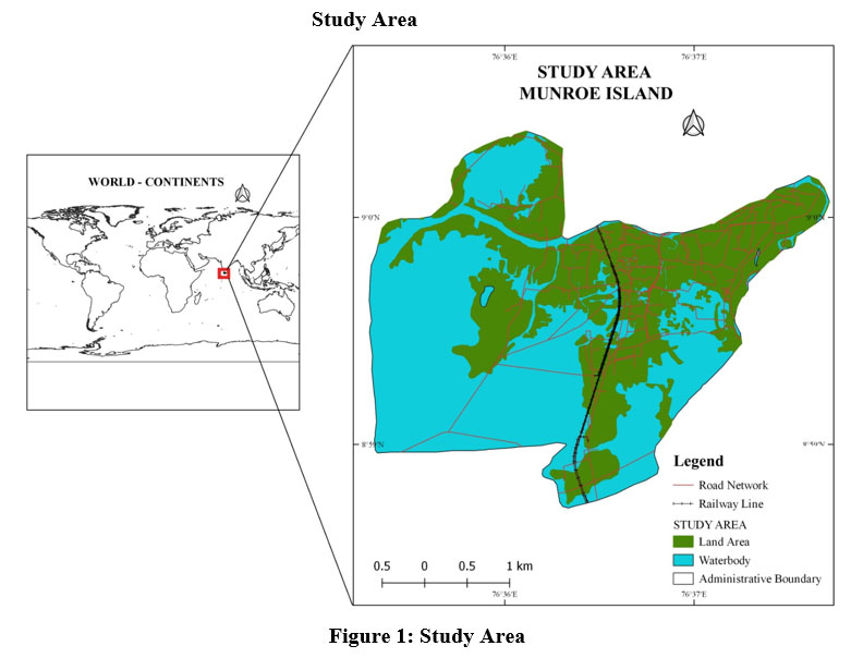 | Figure 1: Study Area |
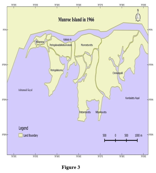
 | Figure 2: Study Area Location Map. |
Mundrothuruth Island, also known as Munroe Island, is a series of islands in the Ashtamudi backwater system in Kollam district. At the confluence of Ashtamudi Lake and the Kallada River, Munroe Island is located. The area is named for the former princely state of Travancore's resident Colonel John Munroe. It is made up of eight smaller islands. Munroe Island is a typical Kerala backwater island community. The island is located between the latitudes of 8° 59' 37.6" N and 76° 36' 35.9" E. Mundrothuruth's administrative village has a total population of 9599 people, with 4636 men and 4963 women 2001-2011census. The island attracts tourists due to its natural beauty with disposition of numerous interconnecting canals. Aquaculture is practiced in modern and traditional aqua farms. Settlements are interspersed with coconut gardens and mixed crops are the dominant land use in the elevated part of the island. The area that lies to the west of railway track is mostly low lying having numerous water bodies and tidal creeks with coconut and natural species, mainly mangrove on the banks. The area had large scale coir retting practices in earlier periods which are now limited to very few locations.
Analysis of the Factors Responsible for Island Sinking
From the present study it is identified that there are so many reasons behind the inundation of the island Munroe. The major reasons behind the inundation of the isle are described below.
Problem Related to Accumulation of Sediments
According to the people of the isle of Munroe, the Kallada irrigation project of 1996 and the construction of the dam in Tenmala badly affected the Munroe IsleKSSP Study Report 2008. The Munroe Island was the delta area which formed due to the biological deposition of loose unconsolidated materials by Kallada river and Ashtamudi lake. This type of material may be easily eroded. Before the construction of Tenmala dam, the copiously flowing Kallada River protected the isle by depositing new sediments during the time of high tide. But the condition altered due to the construction of Tenmala Dam, which stood as a barrier to the flood water carrying sediments. For maintaining the stability of the island continuous accumulation of sediments by Kallada river and Ashtamudi lake is to be needed. Most of the respondents opinioned that they detected the problem of inundation, sinking and shrinking of island after the commencement of Thenmala Dam for the purpose of Kallada irrigation project. The sediment deposits were not possible as the water flow decreased considerably in the Kallada Rive. Thus certain part of the isle slowly merged with the water and total area of the isle decreased. It is said that the Kallada Irrigation Project brought no benefit to isle.
Effects of 2004 Tsunami
The Tsunami waves hits the Kerala cost in 2004 badly affect the physiographic set up of the island. The strong waves washed the base sediments from the continental shelves of adjacenting Arabian Sea. Due to this reason the water carrying capacity of sea in these parts increases and it badly affect the Munroe island during its tides. After this phenomenon the strength and inflow of tidal water increases and accelerated the rate of soil erosion and inundation by tidal flooding. The island was only hit by tides twice a year before the Tsunami. Tsunamis, on the other hand, cause tidal flooding eight times a year, and the water stays for weeks.
Climate Change
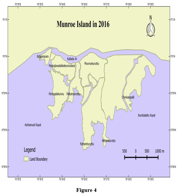
Some study reports of 2017 points out that, due to global warming, ice in the polar regions got melted to increase the water in the oceans eventually leading to the submergence of a vast area of land Hindusthantimes 22 November 2017. It is predicted that Mumbai and Kochi will be the first victims of this phenomenon. But the natives claim that Munro isle was the first victim of such submergence. The records say that the area was sunken up to 1 meter in 1996-2006 and up to 3 to 4 meters in 2006-2016 due to the increased level of salt water. It is found that there were no signs of damage to the walls of the houses, but the interior of the houses were filled with water as a result of the increased water level, causing damages to the building equipments, furniture, etc.
 | Figure 3 |
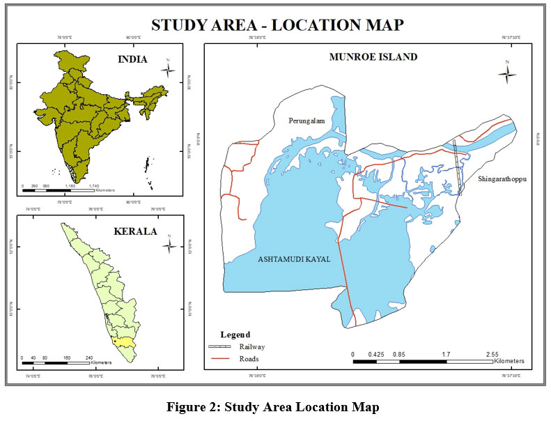
 | Figure 4 |
A study conducted by Kerala Sasthra Sahithya Parishad also found that Munroethuruthu was sinking as a result of rising water levels, which are a result of global warming. Due to global warming sea surface temperature severely increased and a large number of low pressure belts created in the Arabian sea in the near past. These severe low pressure belts leads to the formation of cyclones and wide spread rainfall in the coastal and main land of Kerala. Severe rainfall in the island accelerated the flood situation and accelerated the process of further sinking. This may also wash away the sediments too. The rise in sea level due to Global Warming and Green House effect also make a greater threat to the physiography, environment and demographic profile of the study area.
Faulty Agricultural Practices
The wide shatter of agriculture in the Munro Island intensified its destruction. For a better income, the people in the island initiated prawn and oyster farming in a wide range. The coconut plantations in the isle completely destroyed. There existed a method of scattering sediments for the coconut plants. But this practice was stopped due to the destruction of coconut plantations. Because of the separation of biotic contents from those areas filled with the deposition of sediments and residue of coconut fiber, these areas got sunken under the lake. Digging of ponds for the purpose of oyster cultivation increased the air circulation and made the process of biotic separation faster. Tillage of land for the cultivation also accelerated the rate of soil erosion.
Construction Activities
As in 2010 the depth of the Kallada River got increased from 5 feet to 20-30 feet because of the wide excavation of sand. Even though the sand excavation was forcefully stopped by law, the practice continues even today. Because of the wide destruction of mangroves, which were the base of hundreds of hectors of land, the marshy areas got destroyed. Unscientifically built roads, bridges and rail lines give more strength for its destruction. Without considering this as an environmentally sensitive area, hundreds of heavy vehicles and more than 62 trains are passing through this isle. The tremor caused by the passage of trains and other vehicles leads to the erosion of soil underneath to Kallada River and Ashtamudi Lake.
The Consequences of Inundation of the Island
Sinking, Shrinking And Salinity
The island is shrinking and sinking as a result of natural and man-made factors. After the 2004 Tsunami, the real elevation of Munroe Island, which was 3 metres above mean sea level, was estimated to have dropped to 5 to 1 metre. Mining and large-scale construction operations are mostly to blame for the island's sinking. The disappearance of small islands has also been linked to sinking. These little islands, which were formerly home to humanity, are now deserted. People are fleeing these small islands because they are finding it difficult to survive due to the saline water that has engulfed the area. The process of sinking is related with the island's shrinking. Due to sinking and continuous contact with water humid walls and cracks were developed in the houses of Mundrothuruth.
Biodiversity Loss
The wide range of mangroves and the rich flora and fauna are destroyed due to various natural and manmade causes such as tourism and construction activities, pond digging for pisciculture etc.. Sinking, shrinking, and suffusion played a major role in the destruction of natural habitats of various plants and animals. All these causes will eventually lead to the disappearance of many plant species. in the destruction of natural habitats of various plants and animals. All these causes will eventually lead to the disappearance of many plant species.
Findings and Suggestions
Sinking, shrinkage, salinity, and saltwater intrusion are all common problems in this area. These concerns have a variety of direct and indirect effects on the islanders' daily lives. Munroe Island is prone to flooding on a regular basis. The islanders who lived in the waterlogged areas abandoned their homes due to the unfavourable climate. The difficulties are most noticeable in the districts on the island's western side. The most perplexed areas are the Kidapram north, Kidapram south, Pattamthuruth, Pezhumthuruth and the water logged regions of Nenmeni in the eastern part. There is an increase in the number of empty houses due to various environmental issues.Munro Island may be considered as the first victim of global warming in the state of Kerala. No reports or study opposes this argument.
The following suggestions are for the sustainable existence of island and islanders, which are obtained through the survey method and for the identified problem in the study area, are:
Planting mangroves
Mangrove plantations have the ability to reduce shoreline erosion. As a result, it aids in the protection of the island from flooding as well as fish spawning. The mangrove's most essential feature is that it can hold silt and aid in collection.
Weightless roofing
The island is under the sinking effect. The heavy weighted roofs increased the effect of sinking, so implement weightless roofing or build one storied houses.
Floating house
In Western countries, floating dwellings are a common sight. These dwellings are important since they are made of lightweight materials and do not sink in water. When there is a flood or the water level rises, we can manage it because it is similar to our houseboats. In flood-prone areas, the construction of floating houses can be a useful strategy.
Electric toilet
Implementation of electric or e-toilet helps in reducing the open defecation and the wastes can be converted in to gases which can be used for electrification and cooking purposes.
Watershed program
Watershed program can be suggested to improve the proper management of existing channels of water flow and enable the quality of drinking water through proper management. 6. Silt management Due to the construction of Kallada dam, the silt deposition can’t be takes place correctly. This leads to the lowering of land due to the stability decreasing. Using proper methods, the silt can be collected along the banks of the water system helps in strengthening the land.
Land upgrading.
Land can be upgrade by proper management. The agricultural and aquaculture activities can be done properly and use biological manures for the cultivation. Avoid the waste disposal in to the land and water. Because this is a land locked area.
Limit the Constructions
Avoid the construction of roads which blocks the free flow of water and remove the blocks which act as the barriers for the retraction of water. Several new resorts and multistoried buildings can be found in Munroe island. This may cause further sinking.
Scientific Agriculture
Control soil erosion by cultivating with scientific methods. Farmers' farming methods in this area are out of date. Adapting scientific crop rotation strategies and using contemporary equipment can help to avoid soil erosion to some extent.
Conclusion
The island is faced by infrastructure, environmental, occupational, population, livelihood and other issues. The consequences of these issues are directly affecting the people. So proper management is inevitable for retain the inhabitancy of the island, otherwise after a fifteen or twenty year it will be vanished into the depth of Kallada river and Ashtamudi lake. More than 400 families left the isle due to lack of shelter and daily income. Many families are now prepared to leave the island. If the situation continues like this, Munro Island will disappear from the map of Kerala within a few years. The culture of a population, its remnants, and irreplaceable environmental beauty would submerge in water forever.
Conflict of Interest
There is no conflict of interest.
Funding Sources
There is no funding sources
References
- Sasidharan. C.K, Sivanandan P, Ecotourism for Inclusive Growth: A Case Study of Ashtamudi Lake.
- Sitaram Nagaraj, Impact of Urbanization on Water Quality Parameters – A Case Study of Ashtamudi Lake Kollam, IJRET: International Journal of Research in Engineering and Technology eISSN: 2319-1163 | pISSN: 2321-7308, Volume: 03, Special Issue: 06, May2014.
- An expert team from the Thangal Kunju Musaliar College of Engineering, Kollam. The team headed by Prof. Gouri Antharjanam, and consisting of Prof. Suniil Kumar, Prof. Sirajudeen, Prof. Sruthi. R. Krishnan, Prof. Amal Azad and Prof. Udayakumar. Hindusthantimes 22 November 2017
- Census report 2001 and 2011, Ministry of Home Affairs, Government of India.
- Central team study on Munroe Island?s Environmental Issues by Centre for Science and Environment (CSE) New Delhi
- District Census Handbook – Kollam (Village And Town Directory), 2011
- The Kerala Sasthra Sahitya Parishad study on Munroe Island- Environmental Issues. Visit to Vembanad Kol, Kerala, a wetland included under the National Wetland Conservation and Management Programme of the Ministry of Environment and Forests, 2008
- Expert Committee Report 2015 on Mundrothuruth Island Environmental Issues by Kerala State Council For Science Technology And Environment . ? Madhyamam weekly, volume 19, 2016 February 22[9] Tanika Chakraborty, Deep Mukherjee, Sarani Saha, Contemporary Issues in Sustainable Development
- The Case of India, 2020, pp 10-16
- Rajasekaran, A study on island tourism industry in Andaman and Nicobar islands problems and prospects, 2015, Department of management studies, Madurai Kamaraj University
- Mukherjee Debasmrity, Changing geo environmental settings of Henry Island and Patibania island in south western sundarban, October 2021, pp. 46-80
- Shee Sumanta Prakash, Process of industrialization and its impacts on Sundra Basin Salboni block Paschim Medhinipur West Bengal India, 2020
- Bera Swagata, An assessment of developmental pressures environmental quality and resource management in south Andaman group of islands, 2020, pp 60-71
- Ana M. C. Santos, Ecology and biogeography of island parasitoid faunas, May 2012, pp 19-24
- Janto Simon Hess, Financing climate change adaptation in small islands: assessing accommodation suppliers’ perceptions in Thailand, Earth science department, University college London, pp23-80


