Assessment of Urban Wastelands using GIS and IoT as Tools for Spatial Data Analysis
Lavanya Vikram
*
 and Monalisa Bhardwaj
1
School of Architecture,
Ramaiah Institute of Technology (VTU),
Bangalore,
Karnataka
India
http://dx.doi.org/10.12944/CWE.18.2.35
Copy the following to cite this article:
Vikram L, Bhardwaj M. Assessment of Urban Wastelands using GIS and IoT as Tools for Spatial Data Analysis. Curr World Environ 2023;18(2). DOI:http://dx.doi.org/10.12944/CWE.18.2.35
Copy the following to cite this URL:
Vikram L, Bhardwaj M. Assessment of Urban Wastelands using GIS and IoT as Tools for Spatial Data Analysis. Curr World Environ 2023;18(2).
Download article (pdf)
Citation Manager
Publish History

Introduction
Kim G. and his colleagues in the year 2018, defined vacant and abandoned land parcels as wastelands1. Land degradation which could be temporary or permanent has been caused due to various physical, chemical, biological, and social factors. The data is updated by the Department of National Remote Sensing Agency, Hyderabad (NRSA) once in ten years to plan essential management programs for reviving the degraded land by the Government of India to mitigate and make them productive land use category. ISRO is collecting data at regular intervals on land degradation, and wasteland generation through satellite imagery with a time range of 2005-20152. National Wasteland Development Board (NWDB) along with National Remote Sensing Agency (NRSA) categorized 13 typologies of wastelands in India.
Methodology
The paper aims to infer and discuss technologies used in mining wasteland at a global level. The purpose of this study is to review the existing literature so as to understand how contemporary technologies enable us to understand mining problems and resolve in finding their solutions more objectively. It aims to show how GIS, remote sensing, and IoT are being used in the wastelands and what could be the future scope in this field. This paper has been developed in the following stages, stage one is through a literature study to know the basic terminology and category of wastelands from various departments like NWDB, NRSA, and Department of Land Resources (DoLR). Stage two is to review the technologies and their application from the micro to macro level in the technological context of IoT, stage three is to understand through literature study the present active IoT technologies applied in the mining sector. The paper concludes with an understanding of the scope and future contemporary applications of the existing technologies in mining wastelands.
Review of GIS, Spatial Data, and IoT Applications in Wastelands
This review paper studies various technologies like Geographical Information Systems (GIS), GIS applications in the field of mining, Remote Sensing (RS) and spatial data analysis, satellite imagery, Internet of Things (IoT), IoT application in mining, and mine sustainability. The study is to understand the need for technologies in the mining sector and their applications in resolving the issues in the field.
Geographical Information System (GIS)
Prof. Jaiswal R. et al, in 2005 studied the comparison of visual assessment and GIS maps obtained, giving a visual estimation of 7 types of land uses with simplified landscape assessment within a 500m radius in a 1:5000 scale. To facilitate the assessment 3 concentric buffers were used in 126m, 333m, and 500 m radii respectively. Each land use pattern was estimated with a special pattern and areas like hedges and roads were also provided special patterns. These were 3 different land use patterns in France with Normandy having grasslands dominate in their landscape. In the agricultural landscape, vineyards dominated the Nouvelle-Aquitaine and hilly agricultural landscape with dominated crops of fragmented oak forest. This data was collected and complete digitizing was performed in ArcGIS software. To compare the question of accuracy a layman was appointed to compare the GIS study with the photographic field study and perform a visual assessment (Simplified assessment).
The second experiment was to have 5 photographs given to 20 students with an agronomy background. Only 5 land use types - crops, forests, grassland, hedges, and urban areas were selected. With the help of visual aids, the students had to calculate the percentage of the total buffer area. During the second round of data, the concentric buffers were considered with similar visual aids. The paper concludes the appropriateness of using the simplified visual assessment and GIS mapping for qualitative assessment by using the Concordance Correlation Coefficients (CCC), visual aids, and GIS mapping. The patch matrix model for agricultural landscapes is suitable and clearly identified through GIS. Visual aids could not give precision in the assessment. Land uses like the forest; grasslands were precisely accurate. The overall accuracy was high for the landscape composition where the qualitative assessment is required3.
Desertification is currently a major environmental concern, 70% of the total land area is dryland. Desertification has conditions like soil degradation, erosion issues, and reduction in biological, chemical, and physical properties, resulting in desertification and wastelands. The author Liu Y. et al., in 2014 observed the spatial inventory, assessment, and monitoring of degraded lands. Remote sensing has proved to be accurate, repetitive coverage, real-time data acquisition, cost-effective, and long-term monitoring facility and has proven to be faster than the ground methods to assess degraded land4.
In the paper Lui and colleagues conclude that data collected in 1991, 2000, 2016 years are mapped based on land degradation and observed that 10.5 % increase in degradation. Vegetal growth and water erosion was the cause of land degradation in the year 1991 and there was an intense spike in mining and quarry during the 2000 which again led to the cause of land degradation, local farmers are giving land on lease for limestone mining, which is almost 600% increase in land degradation. In 2016 limestone mining in agricultural land has increased the degradation 10 times that of 20005.
To understand the terrain characteristics at the regional level with the help of remote sensing data as an efficient tool with multi-temporal image coverage. The thematic maps integrated by GIS with suitable groundwater prospects and demarcating the forest fire risk zones. It could also derive other databases like development plans. Remote sensing would study the utility of other assessment of natural resource potential at regional and local level3.
Lui et al.(2014), has explained the various maps and provided a detailed planning scheme for the local government, this study would give an insight on decision making, land use policy and come with unique solutions5.
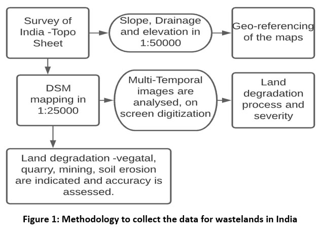 | Figure 1: Methodology to collect the data for wastelands in India
|
Source: Author
GIS application in Mining
The introduction of GIS to map wastelands in India started from the year 1986 when the Planning Commission of India defined that the poor management of soil and water leads to land deterioration and can be declared as degraded land (National Wasteland Development Board- NWDB, 1987). Geographical Information System enables us to identify the areas, integrate models, and make trade-off calculations. In India around 25% of the land is wasteland and the magnitude and importance of safeguarding the land resources are a responsibility. The methodology to collect the data of wasteland in India through satellite imagery is shown step-wise in Figure 1. The authors Sahay S. and Walsham G. (1996) in their paper elaborated on the literature of how in developing countries implementation of GIS has been able to adapt, including the involvement of different sectors. It aims at developing a more comprehensive data management strategy, providing the balance between technical and social aspects of the projects6.
Remote Sensing for Spatial Data Analysis
The author Mensah F. et al., in 2015 explains the loss of biodiversity, decline in agricultural productivity, forced migration and major socio-economic concerns in Ghana which has caused the land degradation and desertification. The comparative satellite images were used taking ArcGIS 9.3 and ERDAS imagine software. The objective of the study was to document the land degradation in Ghana and the model trends of land degradation and create a hazard map. It was found that 880.06 sq.km of the land was degraded in the Ghana region7.
Increasing community participation, education among the locals, vocational training programs, decision-making process, statutory regulation, and legislation implementations are the key to having socio-environmental sustainability 8.
Internet of Things (IoT)
Generation of wastelands are of large-scale and small-scale depending on the type of mining, the author Sunhare et al., (2020) in the study on various techniques employed in IoT application for the wasteland to formulate an intelligent environment. In this IoT environment the big data mining and cloud assisted IoT is well understood.
 | Figure 2: IoT Applications from small scale to large scale, Source8
|
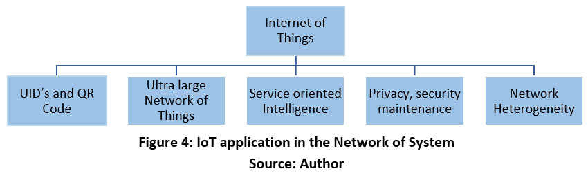
Artificial intelligence and computer science department are contributing on prototype smart IoT models to manufacture and work smartly. To name a few like Internet of Things (IoT), Mobile Computing (MC), Wireless Sensor Networks (WSN), Machine to Machine communication (M2M), Pervasive Computing (PC), Cyber-Physical System (CPS) etc. The IT sector is working on various other concepts to set standards for a sustainable and smart environment8.
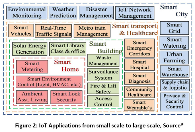
The idea is to connect everything to the internet and to humans. IoT is considered as a smart way to connect with humans, compute data can also take decisions and give the appropriate solution by coordinating with humans worldwide. There are several applications ranging the usage from micro-scale residence to a macro-scale smart city concept. The large-scale smart city concept envelops around the smartphone, smart building, transport, healthcare and other smart managements importantly the devices, network privacy and security control management as shown in Figure 2. A few IoT applications have been discussed below:
Unique Identification of devices
IoT Infrastructure: all the devices, payment modes and other independent enquires have QR codes, Bluetooth connectivity, and ID solutions. They are all name-centric or big data-centric, the IoT Data Mining: Unique ID’s make you better understand data for acquiring, storing, and managing trillions of devices and related features.
Ultra large-scale network of things
IoT infrastructure: For ultra large-scale areas a blanket of IoT infrastructure has to be embedded where it serves the needs intelligently. In such large-scale projects, the time duration taken is 25-40 years of mining lease, during this time period there would be environmental changes, resource constrained devices to monitor those changes constantly through the devices.
IoT data mining: The issues here are data storage, privacy, security, processing limitation, real-time data, etc. The techniques of pre-processing of data could be feature selection and data filtration and pattern reduction can all be achieved in the data mining process.
Device and network-level heterogeneity
Ubiquitous integration, interaction, and Interoperability
Cluster formation, accommodating heterogeneity in architectural clusters and synthesizing the new challenges by providing services, technologies, and applications. This will be able to extract the data from a large-scale data set but certainly has to deal with dynamic, uncertain, and incomplete data. Research is needed to dynamically connect the devices in a large network system, and incorporate centralized middleware and innovative services.
Service-oriented intelligence
The IoT environment could be remote or mobile-operated and powered which may not work consistently 24/7. The system may require Ad-hoc applications as the infrastructure may demand various services while making the architectural grid system.
Privacy, Security, and trust management
The aspects like privacy, security, and trust management must be an integral part of all the systems. The emergency system with health care, protection control, and entertainment with all the personal data is all required to have security and privacy locked. In the case of hacking, it could be a threat to many lives. Nowadays the phone is maintaining many details and also shares a lot of private details/ information, these are getting connected to a lot of bigger systems and uninterrupted smart environment services. Ad-hoc systems are a major threat to privacy and security application. One needs to address the privacy issue at every level with adequate management solutions8.
In recent time climate change and environmental monitoring and management have been a global concern. The novel idea of cloud computing, Integrated Information System (IIS) which combines the Internet of Things, Geoinformatics [remote sensing (RS), geographical information system (GIS), and Global Positioning System (GPS)], and e-Science for environmental monitoring and management along with a case study9.
Internet of Things Application in Mining
The article speaks on the advanced technologies used for the process of ongoing mining sites. The applications used here are IoT sensors, cameras, Under Ground Long Term Evolution (LTE) networks, and also a powerful private cloud for the blasting and tunneling in real time with IoT in mining. IoT applied to detect the dangerous gas or potential tunnel collapse. IoT reaches new depths by having Wi-Fi mesh all over the mining area and would be able to get connected to every corner of the site. Sweden and Norway may be the hub of IoT mining, as Swedish mining company has a stretch of kilometers of below-the-ground mining and this is completely headed towards the automated systems10.
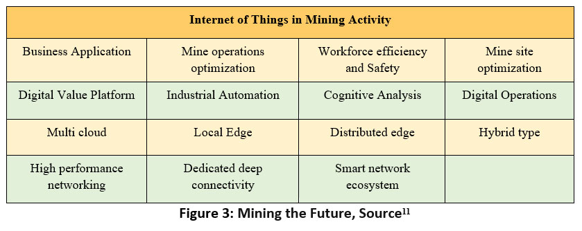
IoT can be applied in mining for unmanned vehicles 24/7 in the mining land. It has been successfully used in Australia. These are GPS-powered vehicles that can function effectively with minimum fuel cost. Problems tackled through IoT are unmanned vehicles which are GPS-powered vehicles, predictive maintenance i.e., when the equipment will need the required maintenance and inventory management of spare parts with IoT management the stock of the spare parts could be brought to the right time without wasting much time. Automatic settlement of the transactions and producing the information reports would be done by the digital control system to save time.
 | Figure 3: Mining the Future, Source11
|
Cloud-based logistics: Technologies with load sharing can enable the mining process easier. Companies can manage the sales contracts, real-time rates, and costs of the product and manage the product flows that control the risks and optimize cost11.
Prof. Bhuiya S. in 2019 studied that mining is technically the most dangerous occupation in the world. The underground mining risks life, and social guarantees in case of injury and are left without assistance. Negative impacts of displacement and loss of livelihood are major concerns of this industry. To overcome these disasters of underground mining the use of technology to intimate with the intelligent sensing and warning system. The radio frequency (RF) technology is used for communication inside the mines12.
Coal mining or any other type of mining there are a lot of safety issues. The author has tried to resolve the critical safety issues of the miners. The air pollution in the underground tends to increase with a lot of gaseous particulate matter and miners in underground areas tend to fall sick and lose consciousness. To overcome this problem a wireless transmitter Zigbee technology and GSM are used to give a warning for the miners to safeguard themselves and evacuate in case of emergencies13.
Internet of Things Application in Sustainable Mining
Mining and sustainability seem contradictory discussions. In 2002 International Council on Mining and Metals (ICMM) Council adopted the Toronto Declaration for the Global Sustainable Development Initiative (MMSD) which tried to initiate a sustainable development initiative. Major factors categorized by MMSD body for sustainable mining are as follows:
Table1: Mining and Metal Sustainable Development (MMSD)9
| Mining and Metal Sustainable Development (MMSD) | ||
1. Analyze the current and future demands
| 2. To develop integrated approaches and practices | 3. Sustainable recycling and reclamation methods
|
Mine and Sustainability:
To avoid accidents and destruction of equipment the system of mine monitoring helps in the closure of the mines. IoT helps to facilitate the reduction in environmental effects of runoff, run-on, percolation, nitrogen, and leaching of chemicals into the surface water and groundwater. IoT has not advanced in obtaining data for quantifying mineral availability. The Internet of Things in Mine Monitoring (IMM) is an upcoming technique in mining activity operations. This helps and facilitates fast decision-making and proper mining action. IoT would be the answer to the challenges of collecting manual data which would otherwise require a significant amount of travel in communication between the field and decision-making. The author has explained the novel methods employed in mining operations can be adapted:
Real-time Mining sensory data: Installing with multiple sensors the challenges of real-time information gathering are decreased.
Autonomous mine monitoring: As the scale of the mining is very large the technology here is able to establish the information on the real-time mine monitoring.
Field-based mining prescription: Each mining site has its own characteristics like soil, climate, field properties, etc. Autonomous mine monitoring data integration has to be developed for the monitoring and fast decision-making process.
Sustainable Mine System Operation: Early warning of disaster in the monitoring system and practical integration of data collection tools to allow effective and fast decisions do not exist.
“The IoT of Sustainable mining has classified mining into 4 types depending on the type of ore deposits:
Surface mining for shallow deposits
Underground mining to access deeper deposits
In situ mining to dissolve the minerals
Placer mining for shifting the minerals” 9
The challenge in IoT-based sustainable mining is to enable the technologies for smooth functioning and futuristic mining operation.
The senses like drones and aircraft work positively for seismic areas, then there is electromagnetic (EM)and ground penetrating radar (GPR) to monitor the seismic zones.
In the field of mineralogy, geology, and hydrology mine monitoring needs to be worked much better with the help of IoT and simulation methods. There is a need to recover the total resource without impacting the environment. To reduce the environmental impact, the economical approach of bio-mining and the usage of bio-agents to extract the minerals also reduce the waste. The cutting and fragmentation of ores and waste to its accurate precision are envisioned with technology.
Mine monitoring is important to monitor the pollutant’s TDS, conductivity, pH, salinity, and also other parameters to ensure the safety of nearby water bodies. Drones in aerial geophysics are used for seismic areas of mining to represent the hyperspectral data.
The life cycle of a mine undergoes the following important steps
Exploration (identification of the ore), 2. Drilling and communication (breaking and separating the ore and waste), 3. Gathering of resources, production unit, processing unit (crushing and grinding) and lastly 4. Closure and Reclamation of land.
Mine monitoring for health and safety: Obstacles like fall, berm and equipment can be detected through hazards using IoT. Lack of ventilation, air quality, cooling and control in underground mining areas is a risk factor for the miners which are managed by the IoT monitoring system.
Environmental Monitoring:
New technologies are identified for evapotranspiration, that can delay the process of infiltration and reduce fine particle emission of dust in the case of acid-mine drainage and acid-generating materials.
Earth Crust monitoring: Research on an integrated mine-monitoring system that can help to detect seismic activity and other underground conditions. It is possible to measure ground motion, displacement, and other disturbances that could indicate potential issues. This kind of monitoring could be a key part of keeping mines safe and productive for everyone involved.
Transportation management: Vehicle loading, ground monitoring, illegal vehicle activity is taken care of by the wireless communication system. Prediction for machinery faults are detected by the sustainable mining IoT systems.
Gas Detection: In mine monitoring, there are various levels to keep track of methane levels and catalytic ball sensors being utilized in IoT. These tools are incredibly useful in ensuring the safety and security of miners and the environment.
Goaf fill monitoring: A cave that is formed for mining in the underground is a goaf. It is important to monitor the goaf strata and see to it that it does not subside and increase the strength of the structure. The goaf tends to accumulate the gas and also may carry the risk of explosion.
Mine fire monitoring: Mining areas are more prone to the fire hazards, sustainability mining in IoT enables us to detect fire, control and warn before the incidence has occurred by sensing the temperature and gas.
Conveyor belt monitoring: Smart conveyor belt, control, sensing damage in the belt and also communication sensing systems are enabled.
Water monitoring: Geophysical sensing methods are employed; this will recognize cracks and geological faults in the structure where there is high water pressure and temperature.
Miner’s tracking: Routers are used for wireless and wire approaches as general communication equipment. This help in locating and detecting the miners who are trapped in the accidents. 3D maps are used for locating the mine worker’s location.
There are different paradigm shift technologies for sustainable mining in IoT.1. Autonomous mining is a robot-based mining system used for underground mining.it can be also used in harsh, inaccessible and remote conditions and places. 2. Waste utilization can be used as building material and construction. Bio mining, use of biological agents for mining the ores and metals. This technique is less pollution and more energy efficient. Advanced analyses can help achieve a more consistent size and uniformity index for rocks, which could be really useful in construction and mining. And when it comes to soil reclamation, there are a variety of techniques that can be used, including the development of vegetation to help restore the soil to its natural state.
There are also different types of sustainable mining IoT for the cleanup and restoration of the mining land. Few methods in this are implemented like electro-kinetics remediation (ER), excavation and disposal, the process of re-vegetation, soil amendments, covering, subaqueous disposal, biosolids., chemical stabilization, biological treatment, Passivation technologies and reuse and reprocessing14.
Inferences and Discussion
The above literature study understands the IoT application in the network of systems, this is applicable in the field of UIDs and QR codes, ultra-large network of things, service-oriented intelligence, privacy, security maintenance, and network heterogeneity as shown in Figure 4. IoT and application-based technology is extensively being used in the market to meet the anthropogenic requirements.
 | Figure 4: IoT application in the Network of System
|
Source: Author
The second part of the review paper demonstrates the current trends in mining-related activities with the Internet of Things. IoT in mine monitoring includes Wi-fi connectivity, temperature control, GPS vehicles, maintenance, radio frequency, wireless mesh, alarm for safety, sensors, GPS trackers, CCTV cameras as graphically represented in Figure 5. The GIS and Remote Sensing spatial imagery is applied for large-scale projects to attain accuracy, and repetition, manage misuse of land use, monitor land degradation, monitoring natural resource depletion like water and soil. These are validated with the process of virtual ground reality checking. Software like ArcGIS-9.3 and ERDAS is used for documentation, analysis of the data from the spatial assessment, and monitoring of images generated. The limitation observed in IoT of Mines Monitoring (IMM) the scale of the project is very large, after obtaining the data from the mines with spatial and temporal images the integration of this data is not available. A need for such a tool in disaster monitoring and early warning system will help in taking precautionary decisions in IMM practices.
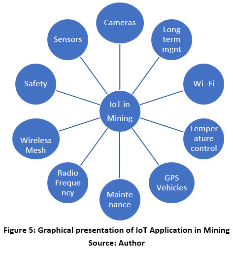 | Figure 5: Graphical presentation of IoT Application in Mining
|
Source: Author
Conclusion
The application of the GIS, Remote Sensing and Internet of Things are all various technologies used in the mining and wasteland management. It is very important to know that the application of the technologies for a small-scale land parcel of wasteland to a large-scale mining project acts as pivotal to the management of large-scale projects. As land resources are valuable to us and it cannot be left in degraded condition for a longer time the usage of IoT helps in the management of environment, air quality, water management, land resources, land uses, etc. It is necessary to understand the gaps and highlight the technical advances for future research to be carried out in the field of IoT.
Acknowledgment
I would like to thank our principal Dr. N V R Naidu and Head of Department, School of Architecture (Research Centre), Ramaiah Institute of Technology, Bangalore and my guide Dr. Monalisa Bhardwaj (Research Guide and Associate Professor) for her constant support and Guidance. I thank the college Ramaiah Institute of Technology- Research Centre, Bangalore, India for facilitating the technical support.
Conflict of Interest
The author takes sole responsibility of the paper and the study carried out for the following: methodology, literature review, interpretation and conclusion and manuscript preparation.
All the sources used for the research are fully acknowledged and cited.
Funding Sources:
There is no funding or financial support for the above research work.
References
- Kim G, Miller PA, Nowak DJ. Urban vacant land typology: A tool for managing urban vacant land. Sustain Cities Soc. 2018;36:144-156. doi:10.1016/j.scs.2017.09.014
CrossRef - NRSC. Wasteland Atlas of India (Change Analysis Based on Temporal Satellite Data of 2008-09 and 2015-16).; 2019.
- Jaiswal RK, Krishnamurthy J, Mukherjee S. Regional study for mapping the natural resources prospect & problem zones using remote sensing and GIS. Geocarto Int. 2005;20(3):21-31. doi:10.1080/10106040508542352
CrossRef - Christian BA, Dhinwa PS, Ajai. Long term monitoring and assessment of desertification processes using medium & high resolution satellite data. Applied Geography. 2018;97(April):10-24. doi:10.1016/j.apgeog.2018.04.010
CrossRef - Liu Y, Tan R, Zhou K, Cui J, Yuan M. Maps for the reclamation of industrial and mining wasteland in Daye County, Hubei province, China. J Maps. 2014;10(1):9-17. doi:10.1080/17445647.2013.847807
CrossRef - Sahay S, Walsham G. Implementation of GIS in India: Organizational issues and implications. International Journal of Geographical Information Systems. 1996;10(4):385-404. doi:10.1080/02693799608902086
CrossRef - Mensah F, Adanu SK, Adanu DK. Remote sensing and GIS based assessment of land degradation and implications for Ghana’s ecological zones. Environmental Practice. 2015;17(1):3-15. doi:10.1017/S1466046614000465
CrossRef - Sunhare P, Chowdhary RR, Chattopadhyay MK. Internet of things and data mining: An application oriented survey. Journal of King Saud University - Computer and Information Sciences. Published online 2020. doi:10.1016/j.jksuci.2020.07.002
CrossRef - Salam A. Internet of Things for Sustainable Mining.; 2020. doi:10.1007/978-3-030-35291-2_8
CrossRef - Shifeng Fang, Li Da Xu, Yunqiang Zhu, Jiaerheng Ahati, Huan Pei, Jianwu Yan and ZL. An Integrated System for Regional Environmental Monitoring and Management Based on Internet of Things. Journal of Information Hiding and Multimedia Signal Processing. 2019;10(1):72-80.
- Silica A. IoT in Mining:Deep Connectivity. IoT Business magazine. Published 2020. https://www.avnet.com/wps/portal/silica/resources/article/iot-in-mining-deep-connectivity/
- Bhuiya S. IoT Application In The Mining Industry. 2019;12(3):8-13.
CrossRef - C. Shobana Nageswari, C.G. Sangeetha VBY. Iot Based Smart Mine Monitoring System. International Journal of Electronics, Electrical and Computational System. 2018;7(4). doi:10.26483/ijarcs.v9i2.5870
CrossRef - Deokar SR, Wakode JS. Coal Mine Safety Monitoring and Alerting System. International Research Journal of Engineering and Technology (IRJET). 2017;4(3):2146-2149.
- Ma Y, Wright J, Gopal S, Phillips N. Seeing the invisible: From imagined to virtual urban landscapes. Cities. 2020;98(January 2019):102559. doi:10.1016/j.cities.2019.102559
CrossRef - Nourjou R, Hashemipour M. Smart Energy Utilities based on Real-Time GIS Web Services and Internet of Things. Procedia Comput Sci. 2017;110:8-15. doi:10.1016/j.procs.2017.06.070
CrossRef - Ng ST, Xu FJ, Yang Y, Lu M. A Master Data Management Solution to Unlock the Value of Big Infrastructure Data for Smart, Sustainable and Resilient City Planning. Procedia Eng. 2017;196(June):939-947. doi:10.1016/j.proeng.2017.08.034
CrossRef - Tagore GS, Bairagi GD, Sharma R, Porte SS, Vishwakarma M. Appraisal of Spatial Distribution of Degraded Lands Using Geo-spatial Techniques. Commun Soil Sci Plant Anal. 2020;(December). doi:10.1080/00103624.2020.1862159
CrossRef - Owusu O, Joseph K, Kobina A. “ Small in size , but big in impact ”?: Socio-environmental reforms for sustainable artisanal and small-scale mining. J Sustain Min. 2019;18(1):38-44. doi:10.1016/j.jsm.2019.02.001
CrossRef - Krupowicz W, Czarnecka A, Grus M. Implementing crowdsourcing initiatives in land consolidation procedures in Poland. Land use policy. 2020;99(February):105015. doi:10.1016/j.landusepol.2020.105015
CrossRef - Santhosh LG, Sivakumar Babu GL. Landfill site selection based on reliability concepts using the DRASTIC method and AHP integrated with GIS – a case study of Bengaluru city, India. Georisk. 2018;9518:1-19. doi:10.1080/17499518.2018.1434548
CrossRef - Zeunert J. Challenging assumptions in urban restoration ecology. Landsc J. 2013;32(2):231-242. doi:10.3368/lj.32.2.231
- Baida PM. Healing wounded landscapes. 2014;(November):17-20.
CrossRef - Gashaw T, Bantider A, Mahari A. Evaluations of Land Use/Land Cover Changes and Land Degradation in Dera District, Ethiopia: GIS and Remote Sensing Based Analysis. Int J Sci Res Environ Sci. Published online 2014. doi:10.12983/ijsres-2014-p0199-0208
CrossRef - Anand A, Winfred Rufuss DD, Rajkumar V, Suganthi L. Evaluation of Sustainability Indicators in Smart Cities for India Using MCDM Approach. Energy Procedia. 2017;141:211-215. doi:10.1016/j.egypro.2017.11.094
CrossRef - Deng D. Research on coal mine electromechanical equipment closed-loop management system based on IOT and information technology. 2011 2nd Int Conf Artif Intell Manag Sci Electron Commer AIMSEC 2011 - Proc. Published online 2011:5101-5104. doi:10.1109/AIMSEC.2011.6011237
- Curulli I. Reuse or abuse? Ethics in requalification design. Places. 2007;19(1):17-21.
CrossRef - Molaei F, Rahimi E, Siavoshi H, Afrouz SG, Tenorio V. A Comprehensive Review on Internet of Things (IoT) and its Implications in the Mining Industry. Am J Eng Appl Sci. 2020;13(3):499-515. doi:10.3844/ajeassp.2020.499.515
- Imran, Ahmad S, Kim DH. Quantum GIS Based Descriptive and Predictive Data Analysis for Effective Planning of Waste Management. IEEE Access. 2020;8:46193-46205. doi:10.1109/ACCESS.2020.2979015
CrossRef


