Sand Auditing for Sustainable River Sand Mining in Kerala, India – An Overview
J. Shaji
*

http://dx.doi.org/10.12944/CWE.16.3.10
Copy the following to cite this article:
Shaji J. Sand Auditing for Sustainable River Sand Mining in Kerala, India – An Overview. Curr World Environ 2021;16(3). DOI:http://dx.doi.org/10.12944/CWE.16.3.10
Copy the following to cite this URL:
Shaji J. Sand Auditing for Sustainable River Sand Mining in Kerala, India – An Overview. Curr World Environ 2021;16(3). Available From: https://bit.ly/39m9iAn
Download article (pdf) Citation Manager Publish History

Introduction
Sand and gravel account for the highest quantity of solid material mined worldwide1. China and India top the list of crucial hotspots for sand mining impacts in rivers2. Unauthorized mining of river sand causes riverbank erosion, loss of riparian habitat, lowering of river beds, shrinking of the delta, and complex impacts on society and economy3. Illegal sand mining is an organized crime that escalates social injustice4. Quantification of bedload sand deposits is significant as it is the sand reserve found on the river bed that can be extracted rather than its suspended load5. Every year, floodwater carries considerable amounts of sediment from upstream catchments, depositing sand, silt, and other aggregates on lowland river reach. Lack of quantitative field-based data on sand availability in rivers and insufficient understanding of sand mining rates results in uncontrolled and indiscriminate sand mining from rivers. Quantitative assessment of sediment deposits in rivers, particularly alluvial rivers, are limited6. Insufficient understanding means evaluating the extraction of sand resources from rivers concerning the sand naturally replenished reliably not possible5. This has lead to river bed lowering, stream bank erosion, depletion of groundwater levels, and deterioration of riverine ecosystems.
Sediment budget is the term used to quantify the source of sediments, sinks, and pathways involved in river systems or coastal zone7. In a river basin, sediment source includes soil erosion in upland, gully erosion, riverbank erosion, valley bluff erosion and valley incision8. River channels and flood plains form the sediment sink. A few studies use the term Sand Budget that considers estimation of sand generation by natural processes, human consumption rate, loss of sand due to erosion and discharge to oceans9. Both flux-based, as well as morphological methods are used in Sediment Budget. Morphological approaches consider bedload transport as the primary mode. Riverbank erosion and collapse of river banks contribute to the sediment budget of natural rivers externally. Regulated rivers do not have sediment supply from the river banks. Surface runoff in the catchments supplies fine-grained sediments to the rivers10. The imbalance in the Sediment Budget of the river causes severe sedimentation and erosion11. Global estimates on sand discharge to oceans from fluvial sources show 5.5 billion tons/year in196812 and 4.1 billion tons/year in 19836. Human activities such as dams, sand mining, land use changes, artificial levees and complex engineering work altered the river load, and complicated the future predications of natural sediment supply13. Estimation of river discharge is crucial in Sediment Budget14. The comparative analysis of input and removal of sand shown a deficit in the Lower Columbia River10. Thus effective river restoration and rejuvenation strategies require Sediment Budget15.The issue of illegal sand mining from rivers in Kerala and its impacts was officially discussed between local stakeholders and decision-makers, and it was realized that the development and enforcement of sand mining laws is a crucial step to handle this problem. As a result, the Kerala Legislative Assembly has issued the Kerala Protection of River Banks and Regulation of Removal of Sand Act in 2001 to control river sand mining and ensure the protection of the State’s rivers. As part of this legal framework, Sand Auditing was adopted to monitor the status of rivers subjected to sand mining. Sand Audit is a kind of sediment budget which is primarly for the realistic estimation of sand deposits available in river for sustainable sand mining. This study presents an overview of River Sand Auditing carried out in Kerala from 2011 to 2019.
Rivers of Kerala
Kerala has 41 west-flowing and 3 east-flowing rivers. River length varies from 16 km (Majewaram River) to 244 km (Periyar)16. Drainage basin area ranges from 52 km2 to 6186 km2. Together with their tributaries and distributaries, these rivers are crucial for maintaining the State's biophysical environment as they flow through highlands, midlands, and lowlands across the State. Keralite's culture, beliefs, social harmony, and economic progress are closely linked with the rivers. The increased population density, economic development through foreign remittance, and low per capita land availability have substantially increased anthropogenic pressure on the rivers of Kerala. Being short and swift-flowing, the rivers of Kerala are highly vulnerable to anthropogenic pressures. Sand mining in Kerala peaked in the early 1970s. Hence, the riverine ecosystems have degraded, riverbed resources, predominantly sand and gravel, were depleted and water quality decreased17. To reverse this trend, Sand Auditing was initiated for rivers in Kerala. The 21 rivers selected for Sand Auditing are shown in Figure 1.
Sand Auditing
Sand Auditing is the process of assessing sand mining activities in a river or a river stretch after a particular period of sand mining18. Identifying sites of sand deposition with potential for mining, fixing the sustainable sand quantity for mining, and ensuring the health and functioning of rivers are the objectives of Sand Auditing. Section 29 of the Kerala Protection of River Banks and Regulations of Sand Act 2001 envisages that Sand Auditing is mandatory for sand mining of any kind from the rivers and their banks across the State19. Sand Auditing in Kerala should be carried out for every river once every three years. Agencies and institutions will be engaged in Sand Auditing. The Centre for Earth Science Studies (CESS) and the Centre for Water Resource Development and Management (CWRDM) are the leading scientific institutions in the field, having conducted Sand Auditing for several southern and northern Kerala rivers, respectively17. Other relevant institutions have also been engaged since 2011-201218.
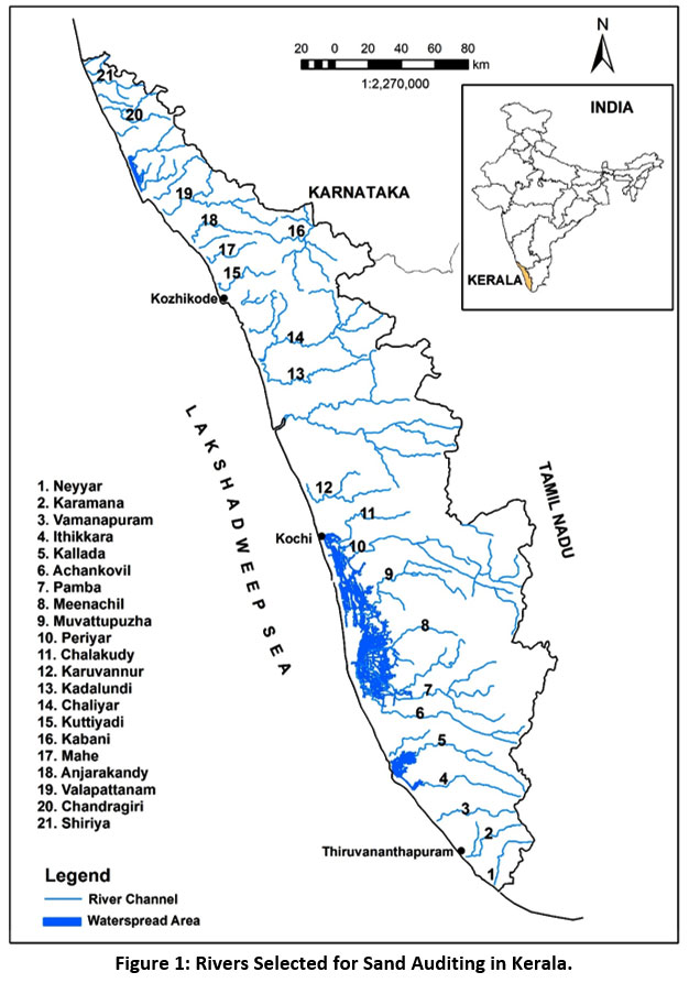 |
Figure 1: Rivers Selected for Sand Auditing in Kerala. Click here to view Figure |
The Methodology of Sand Auditing
The methodology of Sand Auditing applied in Kerala was jointly developed by CESS and the Institute of Land and Disaster Management (ILDM) in 2011-201218. The guidelines issued by the Hon’ble Supreme Court in 2012 on the Deepak Kumar vs. State of Haryana case are included in the Sand Audit methodology. Similarly, the Sustainable Sand Mining Management Guidelines notified by the Ministry of Environment, Forest and Climate Change in 2016 are also applied in Sand Auditing20. The steps involved in Sand Auditing are shown in Figure 2.
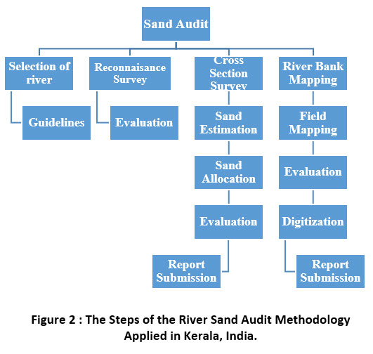 |
Figure 2 : The Steps of the River Sand Audit Methodology Applied in Kerala, India. Click here to view Figure |
The selection of rivers for Sand Auditing is primarily based on the average river width (> 40 m), the terrain’s characteristics, and the availability of sediment deposits. River channels within forested areas and Coastal Regulation Zones are excluded from Sand Auditing, as sand mining is prohibited in these areas. River selection is followed by a Reconnaissance Survey, in which data regarding the physical and social properties of the river basin are collected. The location of man-made structures, sand mining areas, sand deposition points are tracked and used for planning cross-sectional surveys for river bed and bank mapping.
Sand Auditing involves cross-sectional surveys of rivers at close intervals using Total Stations, Auto Levels, and Dumpy Levels. Each cross-section is surveyed based on a permanent benchmark structure established on the river bank. Benchmarks are used for future reference by recording their GPS coordinates, survey numbers and taking photographs. The interval between cross-sections may be reduced based on channel morphology, size, and extent of the sand deposits. The survey is conducted only during the summer season (February to May) in Kerala18, and the minimum summer water level in the river is recorded at each cross-section along with the depth of the sand bed using spiking and quarrying methods. The summer water level is considered as the quantity of water flowing through a specific section of the river during the lean flow season21. Water depth, riverbed material other than sand, altitude and slope of river banks, wetted valley width and Thalweg are also recorded18. A cross-section from the Chaliyar River, Malappuram District, is shown in Figure 322.
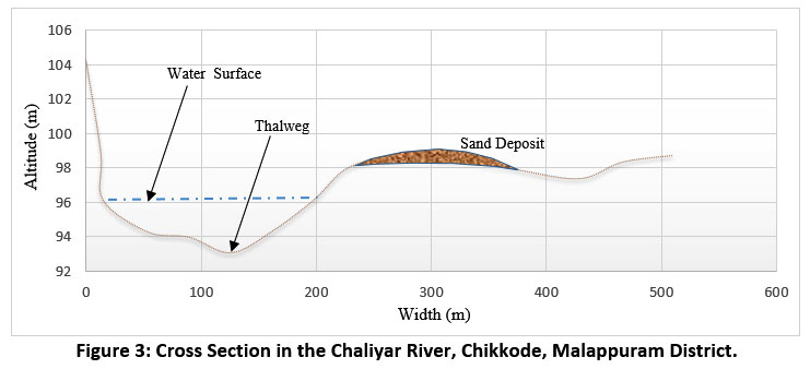 |
Figure 3: Cross Section in the Chaliyar River, Chikkode, Malappuram District. Click here to view Figure |
Sand availability 2 m below the summer water level is analyzed. The volume of sand is calculated by multiplying the cross-sectional area of sand with its zone of influence. The cross-sectional area is calculated by comparing the surface level with the sand level in the cross-section. The zone of influence is estimated as half the distance between two adjacent cross-sections. If the estimated sand volume between two adjacent cross-sections varies by more than 50%, an additional in-between cross-section will also be surveyed. The total quantity/volume of sand in the river is calculated by summing up all cross-sectional sand volumes across the reach surveyed. The biophysical properties of the river banks and their man-made structures are mapped on the cadastral scale through River Bank Mapping as part of the Sand Audit process.
The Hon’ble Supreme Court of India ordered to limit the depth of sand mining from rivers to max. 3 m or to match the water level, whichever is less. This indicates that sand deposits available above the summer water level can be mined, but no sand mining can be carried out below the water level. Buffer distance from the river bank and the irrigation structures and ecologically sensitive areas are worked out for the sand mining proposed sites. Hence, the total quantity of sand and the volume of sand available above the summer water level is estimated separately for each Local Self Government Unit (Panchayat). The areas of sand accumulations potentially suitable for mining are demarcated in India’s Cadastral Map, and their mining feasibility is evaluated. A sample map showing cross-section locations, structures, benchmarks, and mineable sand distribution in the Chaliyar River is provided in Figure 4. The quality of data is scrutinized and verified in the field by technical personnel of the River Management Centre, established by the Government to coordinate and monitor Sand Auditing.
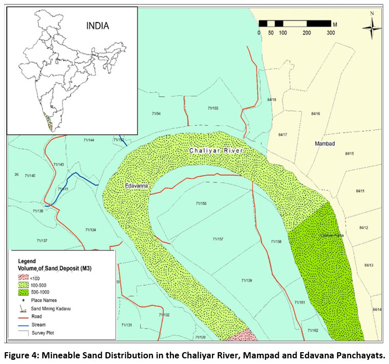 |
Figure 4: Mineable Sand distribution in the Chaliyar River, Mampad and Edavana Panchayats. Click here to view Figure |
Mode of Implementation
Realizing the considerable workload involved in Sand Auditing, the Government of Kerala decided to conduct the Sand Auditing in a more participatory way. As part of this, Earth Sciences departments of Universities and Colleges, Civil Engineering Departments of Engineering Colleges, and accredited Non-Governmental Organization in the field were selected through proper channels and are given field training by experts. Standard guidelines and data formats are also provided to maintain uniformity in data collection and data analysis, and report preparation. Seventeen institutions participated in Sand Audits in the State during 2011-2019.
Status of Sand Auditing
Sand Auditing is conducted in different phases in the State. The pilot work was carried out in the Karamana River, Thiruvananthapuram District, in 2011-2012. Based on the excellent field-work results, four additional rivers were selected for Sand Auditing. Subsequently, 15 new rivers were added, and Sand Auditing was completed during 2011-2019. Sand Auditing experience from 20 rivers helped to extend this work in 10 more rivers and five major tributaries in 2017. Sand Auditing of 21 rivers was completed during 2011-2019. The Sand Audit process of Vamanapuram River23, Thiruvananthapuram District, was completed in 2012. Kallada24 and Neyyar25 rivers were surveyed in 2013 and the Chaliyar26, Chandragiri27, Ithikkara28, Kuttiyadi29, and Periyar30, Pamba31 Rivers in 2014. The Karamana32, Meenachil33, Chalakudy34, Anjarakandy35, Kabani36, Kadalundi37, Karuvannur38, Muvattupuzha39 rivers were surveyed in 2015. Sand Auditing of Valapatanam40 and Achankovil41 rivers was completed in 2017, while Mahe42 and Shiriya43 rivers were audited in 2019. The length of the rivers surveyed and the main recommendations from Sand Auditing are shown in Table 1.
Table 1: List of Rivers Completed for Sand Auditing.
|
No. |
River |
Length (km) Covered |
Recommendation of Sand Audit Report |
|
1 |
Neyyar |
40 |
Prohibition of Sand Mining |
|
2 |
Karamana |
32 |
Prohibition of Sand Mining |
|
3 |
Vamanapuram |
43 |
Prohibition of Sand Mining |
|
4 |
Ithikara |
43 |
Restricted Sand Mining |
|
5 |
Kallada |
45 |
Prohibition of Sand Mining |
|
6 |
Achankovil |
88 |
Restricted Sand Mining |
|
7 |
Pamba |
60 |
Restricted Sand Mining |
|
8 |
Meenachil |
42 |
Prohibition of Sand Mining |
|
9 |
Muvattupuzha |
52 |
Restricted Sand Mining |
|
10 |
Periyar |
59 |
Restricted Sand Mining |
|
11 |
Chalakudy |
41 |
Prohibition of Sand Mining |
|
12 |
Karuvannur |
16 |
Prohibition of Sand Mining |
|
13 |
Kadalundi |
88 |
Restricted Sand Mining |
|
14 |
Chaliyar |
53 |
Restricted Sand Mining |
|
15 |
Kuttiyadi |
23 |
Prohibition of Sand Mining |
|
16 |
Kabani |
56 |
Prohibition of Sand Mining |
|
17 |
Mahe |
29 |
Restricted Sand Mining |
|
18 |
Anjarakandy |
43 |
Prohibition of Sand Mining |
|
19 |
Valapattanam |
58 |
Restricted Sand Mining |
|
20 |
Chandragiri |
21 |
Prohibition of Sand Mining |
|
21 |
Shiriya |
37 |
Restricted Sand Mining |
Environment Clearance for River Sand Mining
Sand is a minor mineral in India. The Hon’ble Supreme Court of India ordered within the Deepak Kumar vs State of Haryana Case that pre- environmental clearance is mandatory for minor mining minerals, including river sand, from Central-Government and State authorities, irrespective of the size of the mining area. The Hon’ble Green Tribunal in 2013 instructed the Central Government to prepare guidelines on river sand mining, applicable to all States in the country. Accordingly, Sustainable Sand Mining Management Guidelines 2016 were prepared by the Central Government in this regard20. As per the guidelines, District Survey Reports, Pre-Feasibility Studies, and Approved Mine Plans are necessary for obtaining environmental clearance for mining areas of size less than 50000 m2. District Survey Reports are to be prepared for each district based on Sand Audit surveys in Kerala. Mine Plans are to be prepared by Recognized Qualified Persons approved by the State Mining Department, based on which sand mining can be carried out. State Environmental Impact Assessment Authority (SEIAA) is the legal authority to give permission for sand mining.
Sand Mining Monitoring System
A three-tier system exists in Kerala to monitor sand mining activities in rivers. A State-Level Committee makes policy decisions; District-Level Expert Committee supervises sand mining at the district level and Kadavu Committees at the panchayat level. These three committees are interdepartmental and have representatives from the Revenue, Water Resources, Law, Police, Labour Departments, and mining workers unions. Legal actions are taken against illegal sand mining based on the Kerala Protection of River Banks and Regulations on Removal of Sand Act, 200119.
Discussion
Sand Audit studies are significant in regulating sand mining activity and ensuring the sustainability of river sand mining. From the various methods of Sand Auditing, cross-sectional surveys are effective for sediment budgets. The sediment budget carried out in the Vedder River, British Columbia, was found helpful as it provides additional information on morphological changes of the river bed44. Kerala carries out sand audits in rivers once every three years. The baseline information generated through cross-sectional surveys is also helpful for river channel management and flood modelling. The users of this large river database range from students to decision-makers. The benchmarks established at close intervals on river banks facilitate the monitoring of riverbed changes that are likely to occur due to sand mining. The participatory approach adopted for sand auditing helped to cover most of State rivers within a short time period. The 17 organizations involved in Sand Auditing became expert agencies, which is a significant contribution to relevant capacity building.
The Sand Audit methodology is simple and can be adopted in other States in their respective efforts to conserve rivers. Considering the utility of Sand Auditing, the Ministry of Environment, Forest and Climate Change has recommended Sand Auditing as a prerequisite investigation for the preparation of District Survey Reports for river sand mining in 202045. The identification and survey of specific sites of sand deposition and the potential to remove sand from rivers help the State control illegal sand mining and avoid associated revenue loss and environmental and social impacts. Continuous cross-sectional surveys of river beds are necessary to calculate the sand replenishment rate in rivers, which could prevent the degradation of river ecosystems since the natural rate of sand replenishment in rivers is altered by the construction of dams, reservoirs, check dams and the rapid land-use changes that take place within the catchments. Like Sand Audit, the cross-section survey method is practised in Malaysia for sand deposit estimation46. Sand inflow estimation was attempted for Periyar River using the formula developed by Mayer-Peter47. This method arrived at optimal sand for extraction from each mining pit. Several other methods are followed in different countries to assess sand and gravel deposits. This includes geophysical methods like electrical resistivity tomography and Sediment Budget Studies48. Sand shortage is reported from 13 rivers in Kerala through that further affects the water sediment balace which is comparable with the Sediment budget attempted in Yangtze River, China49. However, Systematic Sand Audit requires modelling of rainfall-runoff, soil erosion, sediment routing, hydraulic and sediment transport data50.
Conclusion
This study provides an overview of river Sand Auditing carried out in the State of Kerala from 2011 to 2019. The participatory approach applied increased the efficiency of the process of Sand Auditing. The quantity of sand available in rivers above the summer water level helps to decide on the sustainable river sand mining levels at each river. The standard guidelines developed for sand auditing helped to ensure that multiple agencies will follow a standard methodology. Different stakeholders use field-based data collected from 21 rivers through the cross-sectional Sand Audit surveys. This data can play a significant role in developing flood models and in formulating sustainable river basin management strategies in the context of massive floods that occurred in Kerala in 2018 and 2019.
Acknowledgement
The author is thankful to Sri. P G. Thomas IAS, Director, Institute of Land and Disaster Management, Thiruvananthapuram for providing the facility to carry out this work. Dr. Srikumar Chattopadhyay, Dr. K. Soman and Sri. John Mathai, former scientists of Centre for Earth Science Studies, Thiruvananthapuram are acknowledged for their valuable contribution in developing the methodology of Sand Auditing in Kerala.
Funding Source
The author received no financial support for the research, authorship, and/or publication of this article.
Conflict of Interest
Author has not any conflict of interest including any financial, personal or otherrelationships with other people or organizations that can influence the work.
References
- UNEP-United Nations Environment Programme.2019. Sand and sustainability: finding new solutions for environmental governance of global sand resources. https://wedocs.unep.org/handle/20.500.11822/28163
- Sreebha S. and Padmalal D.2011. Environmental impact assessment of sand mining from the small catchment rivers in the southwestern coast of India: a case study. Environ Manage. Jan; 47(1):130-40. doi: 10.1007/s00267-010-9571-6.
CrossRef - Ouillon S.2018. Why and How Do We Study Sediment Transport? Focus on Coastal Zones and Ongoing Methods. Water, 10(4), 1-34.
CrossRef - Best J., Darby S. E. 2020. The Pace of Human-Induced Change in Large Rivers: Stresses, Resilience, and Vulnerability to Extreme Events. One Earth. 2020 Jun 19;2(6):510–4. doi: 10.1016/j.oneear.2020.05.021.
CrossRef - Hackney C.R., Darby S.E. and Parsons D.R. 2020. River bank instability from unsustainable sand mining in the lower Mekong River. Nat Sustain 3, 217–225 (2020). https://doi.org/10.1038/s41893-019-0455-3.
CrossRef - Milliman J.D., and Meade, R. 1983. World-wide Delivery of River Sediment to the Oceans. Journal of Geology, Vol. 91, p. 1-21.
CrossRef - Hinderer M. 2012. From gullies to mountain belts: A review of sediment budgets at various scales. Sedimentary Geology 280: 21–59. DOI: 10.1016/j.sedgeo.2012.03.009.
CrossRef - Faith A. F. 2014. A Geologic Approach to Field Methods in Fluvial Geomorphology, Chapter 5.2, Editor(s): Mary J. Thornbush, Casey D. Allen, Faith A. Fitzpatrick, Developments in Earth Surface Processes, Elsevier,Volume 18, Pages 201-230, https://doi.org/10.1016/B978-0-444-63402-3.00012-1.
CrossRef - Robert C. L. 2009. A global sand budget, a discussion of sand generation, use and destruction, are we running out of sand? Transactions of the Missouri Academy of Science, Volume 43 (2009), pp. 26-32.
CrossRef - William J. Templeton and David A. Jay. 2013. Lower Columbia River Sand Supply and Removal: Estimates of Two Sand Budget Components, Journal of Waterway, Port, Coastal, and Ocean Engineering, 139:383-392, DOI: 10.1061/(ASCE)WW.1943-5460.0000188.
CrossRef - Roy M. Frings, Nicole Gehres, Markus Promny, HansMiddelkoop, Holger Schüttrumpf and Stefan Vollmer. 2014. Today's sediment budget of the Rhine River channel, focusing on the Upper Rhine Graben and Rhenish Massif, Geomorphology, 204, 573–587. http://dx.doi.org/10.1016/j.geomorph.2013.08.035.
CrossRef - Holeman J.N. 1968. The Sediment Yield of Major Rivers of the World. Water Resources Research, Vol. 4, p. 737-747.
CrossRef - Mead A. Allison, Charles R. Demas, Bruce A. Ebersole, Barbara A. Kleiss, Charles D. Little , Ehab A. Meselhe, Nancy J. Powell, Thad C. Pratt, and Brian M. Vosburg. 2012. A water and sediment budget for the lower Mississippi–Atchafalaya River in flood years 2008–2010: Implications for sediment discharge to the oceans and coastal restoration in Louisiana, Journal of Hydrology 432–433, 84–97 doi:10.1016/j.jhydrol.2012.02.020.
CrossRef - Guy Gelfenbaum, Christopher R. Sherwood, Curt D. Peterson, George M. Kaminsky, Maarten Buijsman, David C. Twichell, Peter Ruggiero, Ann E.Gibbs and Christopher Reed.1999. The Columbia River Littoral Cell: A Sediment Budget Overview, Preprinted from Coastal Sediments ’99, Proceedings of the 4th International Conference on Coastal Engineering and Coastal Sediment Processes American Society of Civil Engineers June 20-24 1999, Long Island, NY
- Annette Schulte-Rentrop, Katinka Koll, Jochen Aberle and Andreas Dittrich.2005. Sediment Budget of A Heathland Sand-Bed River, Acta Geophysica Polonica, Vol. 53, no. 4, pp. 553-565
- Centre for Water Resource Development and Management.1995. Water Atlas of Kerala, p10-14.
- Padmalal D. and Maya K. 2014. Sand Mining. Environmental Impact and Selected Case Studies. Environmental Science and Engineering. Springer, Dordrecht, pp 81.
CrossRef - Chattopadhyay S., John Mathai, Thomas P. G., Sajith Babu D., Madhusoodanan K., Shaji J., and Saniya N. 2019. Handbook on River Bank Mapping and Sand Auditing. Institute of Land and Disaster Management, p 27-36. https://ildm.kerala.gov.in/wp-content/uploads/2020/01/Handbook-Final_file_22.07.2019REDUCED-1.pdf
- Kerala Gazette.2002. The Kerala Protection of River Banks and Regulation of Removal of Sand Act (2001). Kerala Gazette, vol 47, No 285, p 14, Government of Kerala.
- Ministry of Environment Forest and Climate Change.2016. Sustainable Sand Mining Management Guidelines, p 21-23. http://www.indiaenvironmentportal.org.in/files/file/ Final%20Sustainable%20Sand%20Mining%20Management%20Guidelines%202016.pdf
- Pandey R., Ramasastri, K.S.2003. Estimation of lean season water availability in streams with limited data. Journal of the Institution of Engineers (India): Civil Engineering Division. 84. 149-152
- Jayarajan C. R., Ajithkumar, Silpa K. S., Soman N., Aiswarya E. S. 2020. Sand Audit Report of Chaliyar River, Malappuram and Kozhikode Districts, Centre for Social and Resources Development, p 228
- Sabu Joseph, and Biju Kumar A. 2012. River Sand Auditing of Vamanapuram River for Sustainable Management. Report, p 9
- Mohankumar S., Abdul Samad, and Nalinakumar S. 2013. Sand Auditing of Kallada River, Kollam District. Technical Report submitted to Government of Kerala by AGES, p 12.
- Anilkumar R .2013. Sand Auditing in Neyyar River, Report, Dept of Geography, University College, p 3-7.
- Jayarajan C. R., Soman N., Ranadiv, Ajith, Muhammad Sageer K., Anas K .C., Prageesh M.K, Mukundan K., and Muhammad Raees V. P. 2014 Sand Auditing Report, Chaliyar, Malappuram and Kozhikode Districts, Centre for Social and Resources Development, p 18-23.
- Bharat Sevak Samaj.2014. Sand Auditing, Chandragiri River, Kasargod District, Project Report, p 5.
- Chattopadhyay S., John Mathai, Chattopadhyay M., Rajappan S., Indu P. N., Bindhu C. T., Resmi P., Lijith P. N., Dhanya V., Nikhil Kannoth, Ragi N. P., Vandana M., Arun Lal, Arun R. 2014. Estimation of Sediment Deposits of Ithikkara River, Project Report, Centre for Earth Science Studies, p 3.
- Balachandran C., Hemachandran C. P., Soman S., Harikrishnan R. P., Anand C. V., Jithendrababu, Lakshmi Chandran, Shameem M.T, Rajesh P.T, Thaslim Khan, Rajesh, Vipin Rag, Nithin, Sulochana, Tharun, Vimala, Rajeesh, Sreejith, and Pravija .2014. Sand Auditing Report, Kuttiyadi River, Kozhikode District. Institution for Rural Development, p 5.
- Centre for Socio-Economic and Environmental Studies .2014. Sand Audit Report, Periyar River, p 3.
- Sanal Kumar S. P., Sreekantan V., Saharsh, Binu S., Deepa N .K., Rajesh S., Rahul C. R., Prajith P., Anuranjan M., Prince F., Arunima S., Sangeetha S., Devika V., Sreejith M. R., Dhanya P., Nazila, Akhilraj, and Rahulraj.2014. Sand Auditing Report, Pamba River, C-Graf, p 11.
- Mohankumar S., Abdul Samad, and Nalinakumar, S.2015. Sand Auditing of Karamana River, Thiruvananthapuram District. Technical Report submitted to Government of Kerala by AGES, p 7.
- Chathukulam J. 2015. Sand Auditing Report, Meenachil River, Kottayam District. Centre for Rural Management, p4-13.
- Rajaneesh P., Luqmanul Hakeem, Denny K. S., Ravi P., Sreevidya, Vancheeswaran, Sooraj, Vaishakh, Vishnu, and Nijo.2015. Sand Auditing Report, Chalakudy River, Thrissur District. River Research Centre, p 173.
- Harish K.V. and Subeesh K. P. 2015. Sand Audit Report, Anjarakandy River, Kannur District District. Uralungal Labour Contract Co-operative Society Limited, p 5-24.
- Arun P. A., Luqumanul Hakeem E., Neeraja K .S., Arun E .V., Ajayan P. A., Shaji N. Y .P, Aslam K., Yunais M. P., Munavar K., Ashrak K. C., Robinson Mathew, Dilnavas Roshan, Jaseel Shyam, Krishnan, Hamdulla A.I, Vinu Bastin Vargheese, Aneesh V.K, Sreedharsh J. 2015. Sand Audit Report, Kabani River, Wayanad District, Ferns Naturalist’s Society, p 12.
- Dominic P. P., Thomas K. L., Sethu K. J., Jinu Aravind, Muhaiyudheen P. and Faizal K. 2015. Sand Auditing Report of Kadalundy River, Malappuram District, p 4.
- Hakeem S., Ravi P., Latha A., Sreejesh, Babu Kodakara, Sreevi,Vancheeswaran, Ajlal C .M., Nikhil and Avinash Don. 2014. Sand Auditing Report, Karuvannur River, Thrissur District. River Research Centre, p 119.
- Tropical Institute of Ecological Sciences .2015. Sand Audit Report of Muvattupuzha River, Ernakulam and Kottayam Districts. Project Report, p 4.
- Reghu Kumar P., Suresh S., Radhakrishnan P. V., Vinod T .R, Baiju P., Reshmi Prabha, Reshma H. and Lakshmi R. 2017. Sand Audit Report of Valapatanam River in Kannur District, Kerala, p 12-13.
- Leena V. P. and Anseer B. 2017. Sand Audit Report of Achankovil River, Pathanamthitta and Alappuzha District, Project Report, p 4-28.
- Govindaraj R., Harish K. V., Manimalai P. M., Thasim Ubaithulla, Sreeshma A. K., Jismol, Abi Thomas, Bibin Babu, and Dineep .2019. Sand Audit Report of Mahe River, Kozhikode District, Uralungal Labour Contract Co-operative Society, p 16.
- Punnen Kurian, Binil Baby, Vinaya D’Cruz, Vinayakumar, Sreekuttan M., Sreerekh P., Sanjayan M.S., Akhil K. R., Jain P. A. and Midhin M. 2019. Sand Auditing of Shiriya and Yalkana River, Kasargod District, Kerala, p 12.
- Martin Y. and Church M. 1995. Bed?material transport estimated from channel surveys: Vedder River, British Columbia. Earth Surface Processes and Landforms, 20(4), Pp 341-367. https://doi.org/10.1002/esp.3290200405.
CrossRef - Ministry of Environment Forest and Climate Change .2020. Enforcement and Monitoring Guidelines for Sand Mining, p 15. http://environmentclearance.nic.in /writereaddata/SandMiningManagementGuidelines2020.pdf
- Department of Irrigation and Drainage (DID)- Government of Malaysia .2009. River Sand Mining Management Guidelines, https://www.engr.colostate.edu/~pierre/ce_old/classes/ce717/Sand%20mining.pdf
- Mattamana B.A., Shiney Varghese and Kichu Paul .2013. River Sand Inflow Assessment and Optimal Sand Mining Policy Development, International Journal of Emerging Technology and Advanced Engineering, Vo.3(3), 305-317. http://citeseerx.ist.psu.edu/viewdoc/download;jsessionid=A5BDB603DC36DB7D1B9BD3B5F9074111?doi=10.1.1.413.5766&rep=rep1&type=pdf
- Chambers J.E., Wilkinson P.B., Penn S., Meldrum P.I., Kuras O., Loke M.H., Gunn D.A. 2013. River terrace sand and gravel deposit reserve estimation using three-dimensional electrical resistivity tomography for bedrock surface detection, Journal of Applied Geophysics, Vol.93, 25-32, https://doi.org/10.1016/j.jappgeo.2013.03.002.
CrossRef - Wang Z.Y., Li Y., and He Y. 2007. Sediment budget of the Yangtze River, Water Resour. Res., 43, W04401, doi:10.1029/2006WR005012\
CrossRef - Abhijith Sathya, Santosh G. Thampi and Chithra N. R. 2021. Development of a framework for sand auditing of the Chaliyar River basin, Kerala, India using HEC-HMS and HEC-RAS model coupling, International Journal of River Basin Management, DOI: 10.1080/15715124.2021.1909604.
CrossRef


