Impact of Climate Change on Gravity Flow Drinking Water Resource in the Upper Kosi Watershed, Lesser Himalaya
Mahendra Singh
*

1
Department of Geography,
Kumaun University,
Nainital,
India
http://dx.doi.org/10.12944/CWE.18.1.31
Copy the following to cite this article:
Singh M. Impact of Climate Change on Gravity Flow Drinking Water Resource in the Upper Kosi Watershed, Lesser Himalaya. Curr World Environ 2023;18(1). DOI:http://dx.doi.org/10.12944/CWE.18.1.31
Copy the following to cite this URL:
Singh M. Impact of Climate Change on Gravity Flow Drinking Water Resource in the Upper Kosi Watershed, Lesser Himalaya. Curr World Environ 2023;18(1).
Download article (pdf)
Citation Manager
Publish History

Introduction
Water is an invaluable, renewable and finite natural resource on the planet Earth. It supports all forms of life and without water resources, life is impossible on the Earth because every living thing uses water to sustain life.1 The whole ecosystem of the Earth is controlled and regulated by the water cycle.2 At present, anthropogenically accelerated climate change has perturbed badly the hydrological system of the Himalayan region which is intensifying the water crisis. A change in variables of climate such as temperature and precipitation which persists for a longer period or decades is known as climate change.3 Several studies reveal that the Himalayan ecosystem is more sensitive for climate change than other terrestrial ecosystem of the world.4,5,6 The mountains are warming with a faster rate than the low lying areas.4,7 The Himalaya is the water tower of Asia which is home of plenty of fresh water resource in the form of snow/glaciers, lakes and mighty rivers.5,8 Several studies reveal that climate change has affected various sectors in mountain ecosystem such as regional spring-fed hydrology,9,10,11,12 agriculture,13 groundwater,14,15,16 biodiversity,17 horticulture18 and animal husbandry.19 Work on the impact of climate change on the hydrological system in the Himalaya region is still less than the other sectors. The climate change is impacting the hydrological phenomenon in the northwester Himalaya region.20 Recent studies reveal that under the impact of climate change the glaciers are melting at unprecedented rates,21 increase in temperature,22 increase in monsoon rainfall,23 change in rainfall pattern, and rhythm perturbation of water bodies and transformation of rivers from perennial nature to seasonal,10,12 decrease in perennial river network during baseflow period caused by groundwater depletion,24,25 increase in extreme events.26,27
Several scholars have studied climate change induced drinking water problems in various ways such as drying of water resources,12 water insecurity,28 poor water management,29 water scarcity,30 unsustainable development of water resources,31 water infrastructure deterioration and depletion,32 drinking water quality and waterborne diseases33 and hydrological drought.34 In the Uttarakhand Himalaya region, gravity flow schemes play an important role in supplying drinking water in the remote village areas and these schemes are more feasible than the other means of water supply method. Due to climate change, the groundwater water table is decreasing very steadily in the study area which has resulted in significant decrease in water discharge capacity of gravity schemes at their source.
The specific objectives of the present paper are to understand the impact of changing climate on water resources of a spring-fed Lesser Himalaya watershed of Uttarakhand, to draw the attention of the regional and international scientists and leaders towards the sustainable water development under the changing phenomenon of climate for the sustenance of life in the fragile ecosystem of Himalaya and to work out the spatial distribution analysis of water depletion in the watershed.
Materials and Methods
About the study area
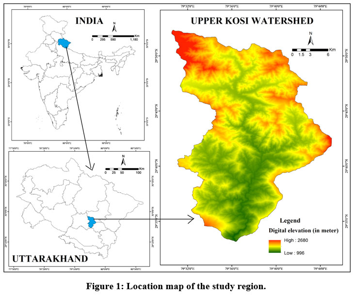
Geographically, the study area, viz., the Upper Kosi watershed is located in the Uttarakhand state’s district of Almora which extends in between 29°33?47?? N to 29°52?20?? N latitudes and 79°33?12?? E to 79°48?11?? E longitudes and encompasses total 463.45 km2 area (Fig.1). Altitudinally, the Upper Kosi watershed varies in between 1041 m to 2714m. The study area is situated in the Kumaun Lesser Himalayan Region. Administratively, this watershed lies in two developmental blocks namely Hawalbag and Takula of district Almora. The upper part of the watershed falls in Takula Developmental Block while the lower part in Hawalbag development block. The study area is bordered by district Bageshwar in the North and North-East, Bhaisiyachhana Developmental Block in the East, Lamgara Developmental Block in the South-East, district Nainital in the South, Tarikhet Developmental Block in the South-West, and Dwarahat Developmental Block in the West. The Kosi is a non-glacial fed river also known as spring fed river which originates from Dharpanidhar in Kausani region of the Takula Development Block. In the starting journey, the Kosi River is known as the Kaushalya Ganga and in Chanoda and Someshwer region Kaushalya Ganga is known as the Kosi River. Near Almora–Nainital district boundary the Swal river joins Kosi at Quarab. The catchment area of this river from Dharpanidhar to Quarab is called the Upper Kosi watershed. The Kosi River makes confluence with the Western Ramganga River in Uttar Pradesh. There are total 323 villages in the watershed.
According to geology, the rocks in the study region are made up of four distinct tectonic units and six lithological formations.35 The study area experiences sub-tropical, cool temperate and cold temperate climatic conditions.The average slope in the study area stands at 20.41° () which varies between 0° slope (valley area) to above 40° slope (hill crest area). The aspect of the study area reveals that the maximum terrain (14.31%) has southern bearing aspect while minimum terrain (10.80%) has western bearing aspect. According to Strahler’s stream order36, the trunk river Kosi is the seventh order stream having a network of total 3053 streams of different orders. The watershed's streams have a combined length of 1527 km and a density of 3.29 km/km2. As per Sentinel-2 satellite data (October, 2019) based land use/cover analysis, from watershed’s total area, about 59.31% part is occupied by forest, 31.11% by barren, 8.57% by agricultural and rest 1.01% by built up area.
 | Figure 1: Location map of the study region.
|
Data collection and data analysis
For the present study, the meteorological data have been derived from the Center of Excellence for Natural Resource Data Management System (NRDMS) in Uttarakhand, SSJ Campus and University, Almora and hydrological data have been collected from the Jal Sansthan Department, Almora which is nodal department for drinking water supply in the State of Uttarakhand. In the present study, a long period (i.e., 1992-2019) meteorological data of six meteorological stations namely Khunt, Salla Rautela, Deolikhan, Kaneli, Kausani and Sitlakhet located in different micro eco-hydrological regions of the study area have been computed. For hydrological analysis, the baseflow water discharge data of 93 gravity flow schemes of the watershed for three base years (i.e., establishment year, 2017 and 2018) and decrease in baseflow water discharge capacity have been analyzed. The water discharge has been measured using the given float method equation:
Q= V x A (where; Q= Discharge, V= Velocity and A= Area).
The mean monthly temperature and rainfall data of the last 28 years (i.e., 1992-2019) have been computed to understand the monthly pattern whereas the mean annual statistics have been used for analysis of trend. The purpose of analysis of trend is to understand whether the values of analyzed parameters have increased, decreased or trendless during the period. The correlation and regression analysis has been computed using the last 28 years meteorological data. For presenting the spatial distribution map of the gravity flow schemes, the GPS collected coordinates have used and processed in ArcGIS software.
Results and Discussion
Meteorological analysis: pattern and trend
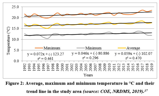
The average annual temperature of the study area stands at 17 °C which varies between 21.5 °C as the maximum, and 12.4 °C as the minimum and the average annual rainfall is recorded 987 mm. The average monthly temperature analysis shows that January is the coldest (9.5 °C) month while June is the hottest (22.1 °C) month in the study area. The month of July contributes maximum rainfall (i.e., average 234.97 mm during 1992-2019) while November as minimum (8.34 mm) in the watershed. Using the temperature data from 1992-2019, the correlation and regression analysis have has conducted (Fig.2 and 3). The average temperature correlation value r2=0.470 reveals that there is positive correlation between time and average temperature. As per the regression equation y=0.059x + (-) 102.07, the mean temperature in 1992 was registered 16.2 °C which has increased to 17.8 °C in 2019. The maximum temperature correlation value r2=0.461 reveals that there is positive correlation between time and maximum temperature. As per the regression equation y=0.072x + (-) 123.27, the mean maximum temperature in 1992 was registered 20.6 °C which has increased to 22.6 °C in 2019. The minimum temperature correlation value r2=0.011 reveals that there is positive correlation between time and minimum temperature. As per the regression equation y=0.046x + (-) 80.886, the mean minimum temperature in 1992 was registered 11.8 °C which has increased to 13 °C in 2019. The rainfall correlation value r2=0.296 reveals that there is positive correlation between time and magnitude of rainfall. As per the regression equation y=2.759x + (-) 4546.41, the mean rainfall in 1992 was registered 950 mm which has increased to 1024 mm in 2019. Thus, the meteorological parameters reveal a positive correlation with time and the trend line shows an increasing trend over the time.
 | Figure 2: Average, maximum and minimum temperature in °C and their trend line in the study area (source: COE, NRDMS, 2019).37
|
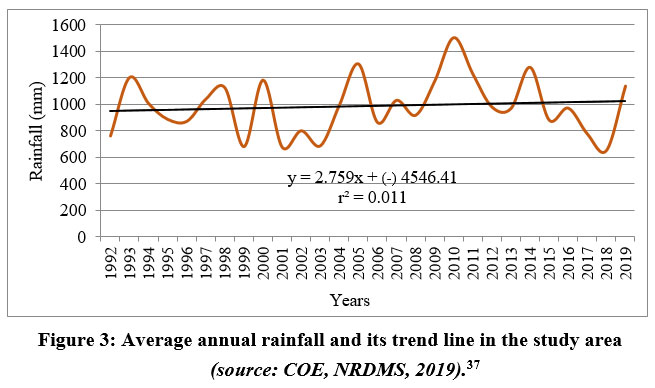 | Figure 3: Average annual rainfall and its trend line in the study area (source: COE, NRDMS, 2019).37
|
Historical background of gravity schemes
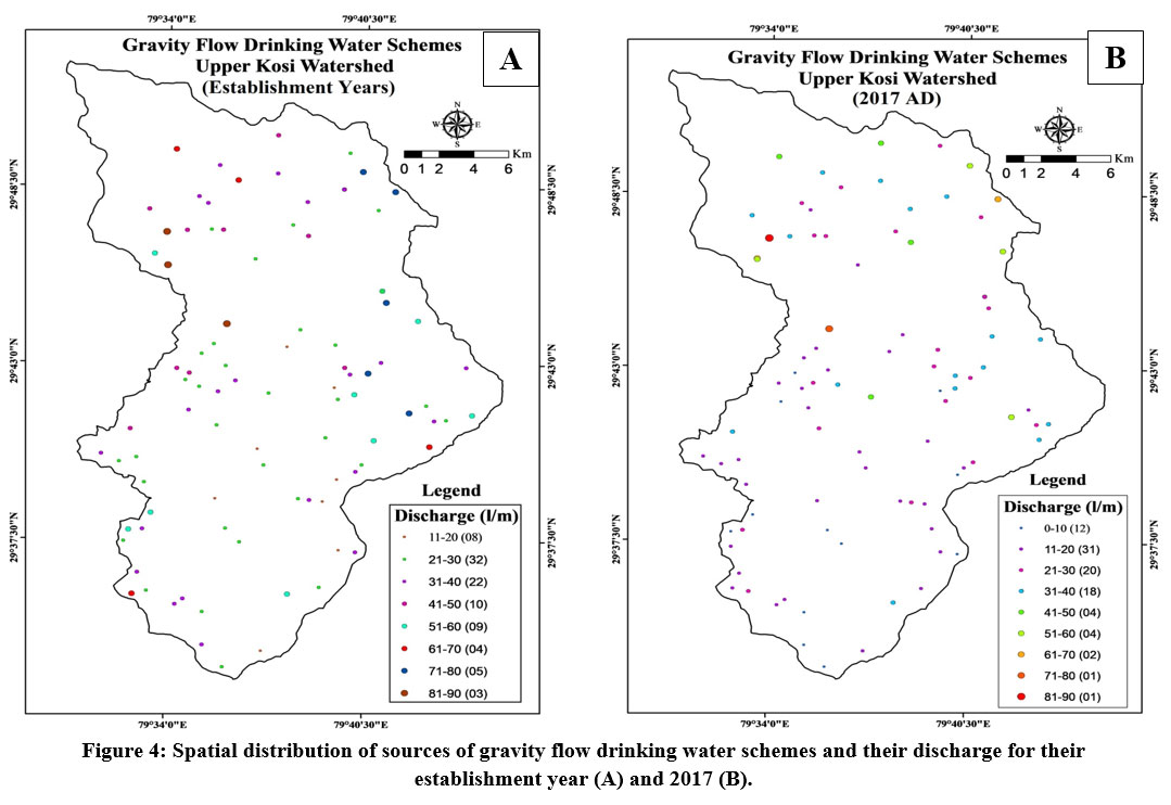
Next to natural spring, the drinking water gravity flow scheme is the second important means of drinking water in the study area. For a long time, the natural springs fulfilled the water needs of the study area but gradually the water discharge of natural springs started to decrease and now the natural springs were unable to fulfill the drinking water needs of the study area. Therefore, to meet the drinking water needs of the study area a new drinking water scheme was started that is gravity flow drinking water scheme. The first gravity flow drinking water scheme was developed during the British period in 1884 by the name of Baldhauti drinking water scheme to meet the drinking water need of the Almora Town area.37 At present, there are as many as 93 gravity flow schemes in the entire study area and the spatial distribution of these gravity flow schemes as per the magnitude of their discharge capacity at their sources is presented in figure 4 and 5. The baseflow water discharge capacity of these schemes is decreasing steadily under climate change impact causing acute drinking water crisis in the villages of the study area. To overcome this drinking water problem, other means of drinking water have been developed in the study area.
Spatial distribution of gravity flow schemes
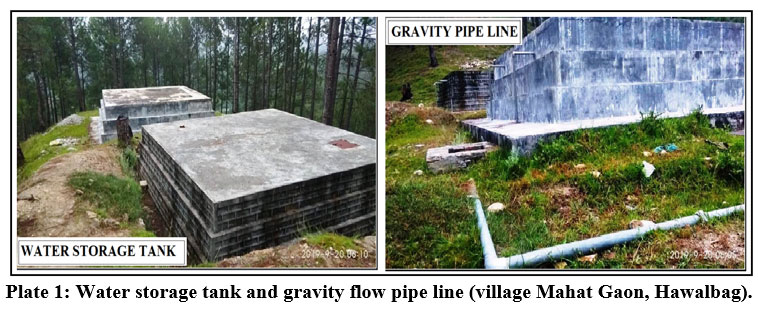
Till the late nineteenth century, we can say that there was the age of Naula and Dhara for drinking water as it was the only means for drinking water. As the population increased, naula and dhara were unable to fulfill supply the required drinking water demand of the study area. Then, another means of drinking water came into existence known as gravity flow drinking water schemes. In simple words, the meaning of gravity flow is to move the water from the upper altitude to the lower altitude by the gravity force of the earth. In gravity flow schemes the water runs as per the gravity or slopes. In gravity flow, water is supplied to the villages and towns by using the principles of gravity force.38 Generally, a water storage tank (water chamber) is constructed near the source of water in higher altitudes (Plate-1) and water is supplied to the villages located in the lower altitudes. Construction of water storage tanks, distribution storage tanks and pipe lines are essential for gravity flow schemes.
Springs and Dhara were the only means of drinking water in the study area till the year of 1884. In 1884, the local sources of water (natural springs) of Almora town meet to the lowest discharge then the government planned to develop a new drinking water scheme named gravity flow schemes to meet the drinking water requirement of Almora town area. The age of Gravity Flow was started with the establishment of Baldhauti drinking water gravity flow scheme. From 1884 to 1931, three drinking water gravity flow schemes, e.g., Baldhauti scheme (1884), Shail scheme (1885) and Syahidevi scheme (1931) were established at the different water sources of the study area.39 The Baldhauti scheme was started from Simtola and Baldhauti forest area and five water sources namely Kajiro Gadhera, Kafligair Gadhera, Chimasim Gadhera, Dhobighat Gadhera and Ganganath Gadhera were tapped for this scheme. The Shail gravity flow scheme was started in 1885 from Shail villages and the Syahidevi gravity scheme was developed from the Syahidevi forest area. In the study area, the current gravity flow scheme was developed in 2013 by the name of Surrounding Villages in the Hawalbag block and after this scheme no new gravity scheme has been developed.
From 1884 to the present, as many as 93 gravity flow drinking water schemes have been developed in the different part of the study area to meet out the need of drinking water in the villages of the watershed. From the total gravity flow drinking water schemes, 44 gravity scheme falls under Takula Development Block and the rest 49 scheme falls in Hawalbag Development Block. There are total 225 beneficiary villages of these schemes.
 | Plate 1: Water storage tank and gravity flow pipe line (village Mahat Gaon, Hawalbag).
|
Discharge pattern of gravity flow schemes
At present, most of the gravity flow schemes are decreasing their discharge at their source which is responsible for drinking water shortage in the villages and towns of the study area especially during the summer season. There are 93 drinking water gravity flow schemes in the study area whose baseflow water discharge pattern has analyzed in this paper. The average water discharge of gravity flow schemes of the study area in the establishment year was recorded 40.11 l/m which has reduced to 26.30 l/m in 2017 and 23.46 l/m in 2018. During the last few decades, a noticeable decrease in gravity flow water discharge is recorded in the study area, i.e., 16.65 l/m water has been depleted. Thus, the study shows that the water flow capacity of gravity flow schemes at their sources is decreasing very steadily in the watershed. The water discharge flow of these schemes for three base years, viz., the establishment year, 2017, and 2018 and the decrease in discharge capacity has also analyzed in this paper (Table-1 and 2). A detailed account of the discharge pattern of the gravity flow scheme’s sources is presented in the following paragraphs.
Water Discharge Pattern in the Establishment Year
The average discharge of gravity flow scheme at their source in the establishment year stands at 41.11 l/m which varies between 15 l/m as minimum to 90 l/m as maximum. All the gravity flow schemes have classified into nine groups based on water discharge capacity in the establishment year. In the establishment year, the maximum number of gravity flow drinking water schemes (32) falls under 21-30 water discharge group and the minimum number of gravity flow schemes (0) comes under 0-10 water discharge group (Table-1). The spatial distribution map of gravity flow drinking water schemes is developed based on their discharge magnitude for the establishment year depicted in figure 4A.
Table 1: Number of gravity flow schemes under different discharge groups (source: Department of Jal Sansthan, Almora).
S.N. | Discharge group | Number of gravity flow drinking water schemes | ||
in establishment year | 2017 | 2018 | ||
1 | 0-10 | 00 | 12 | 17 |
2 | 11-20 | 08 | 31 | 33 |
3 | 21-30 | 32 | 20 | 20 |
4 | 31-40 | 22 | 18 | 14 |
5 | 41-50 | 10 | 04 | 03 |
6 | 51-60 | 09 | 04 | 02 |
7 | 61-70 | 04 | 02 | 02 |
8 | 71-80 | 05 | 01 | 02 |
9 | 81-90 | 03 | 01 | 00 |
Total | 93 | 93 | 93 | |
Water Discharge Pattern in 2017
The average discharge of gravity flow schemes in 2017 stands at 26.30 l/m which varies between 08 l/m as minimum to 85 l/m as maximum. All the gravity flow schemes have classified into nine groups based on their water discharge pattern in 2017. In 2017, the maximum number of gravity flow drinking water schemes (31) falls under 11-20 water discharge group and the minimum number of gravity flow schemes (01) fall under 71-80 and 81-90 water discharge group. The spatial distribution of sources of gravity flow schemes with their baseflow discharge magnitude in 2017 is presented in figure 4B. Where, 62 gravity flow schemes were under 0-40 discharge group and 31 gravity schemes were under 41-90 discharge group in the establishment year and in the year of 2017 this scenario changed, 81 schemes reached under 0-40 discharge group and 12 under 41-90 discharge group. This shows that the drinking water gravity flow schemes are being transforming from high discharge capacity into low discharge capacity schemes in the study area (Table-1).
 | Figure 4: Spatial distribution of sources of gravity flow drinking water schemes and their discharge for their establishment year (A) and 2017 (B).
|
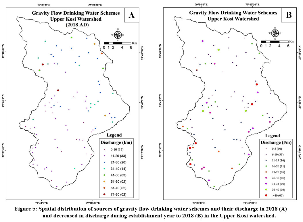 | Figure 5: Spatial distribution of sources of gravity flow drinking water schemes and their discharge in 2018 (A) and decreased in discharge during establishment year to 2018 (B) in the Upper Kosi watershed.
|
Water Discharge Pattern in 2018
In 2018, the average discharge of these gravity flow scheme was recorded 23.46 l/m which varies between 07 l/m as minimum to 78 l/m as maximum. All the gravity flow schemes have classified into nine groups based on their baseflow water discharge magnitude in 2018. In 2018, the maximum number of gravity flow drinking water schemes (33) falls under 11-20 water discharge group and the minimum number of gravity flow schemes (00) falls under 80-90 water discharge group. The spatial distribution of sources of gravity flow schemes with their baseflow discharge magnitude in 2018 is presented in figure 5A. Where, in the establishment year, 62 gravity flow schemes were under 0-40 discharge group and 31 gravity schemes in 41-90 discharge group and in the year of 2018, 84 and 09 gravity flow schemes were found in the same discharge groups, respectively (Table-1). This analysis shows that how rapidly the gravity flow drinking water schemes are changing their nature from higher water discharge capacity to lower discharge capacity schemes.
Decrease in Water Discharge Capacity
A detailed account of decreased water discharge pattern of gravity flow drinking water schemes of the watershed is given in Table-2. The water discharge difference is analyzed in this section between in the establishment year and 2018. During this period, on an average, about 16.65 l/m/scheme water has decreased in the watershed. There are 58 gravity flow schemes which fall below the average decreased water discharge capacity and 35 schemes are fall above the average decreased water discharge capacity. Based on decrease in water discharge, all the gravity flow schemes have been categorized into nine decreased water discharge groups. The highest number of gravity flow schemes (31) is fall under 6-10 l/m (i.e., 31 schemes which accounts for 33.33% of total schemes) decreased water discharge group while the lowest number of gravity flow schemes (03) is fall under 36-40 l/m (i.e., 03 scheme which accounts for 3.23% of the total) decreased discharge group (Table-2). The spatial distribution of gravity flow drinking water schemes is developed based on their decreased discharge pattern (Fig. 4D). Thus, the study reveals that the climate change has perturbed the water resources in the study area very badly and if the present condition continuous, in near future the drinking water problem will be intensified caused by unavailability of water at the sources of drinking water schemes.
Table 2: Number of gravity flow schemes and decrease in water discharge in the Upper Kosi watershed (Source: Department of Jal Sansthan, Almora).
S.N. | Discharge group | Number of gravity flow | Gravity flow |
1 | 0-5 | 10 | 10.75 |
2 | 6-10 | 31 | 33.33 |
3 | 11-15 | 16 | 17.20 |
4 | 16-20 | 11 | 11.83 |
5 | 21-25 | 05 | 5.38 |
6 | 26-30 | 06 | 6.45 |
7 | 31-35 | 06 | 6.45 |
8 | 36-40 | 03 | 3.23 |
9 | < 40 | 05 | 5.38 |
Total | 93 | 100.00 | |
Particular Scheme Specific Analysis
A detailed account of decreased water discharge pattern of gravity flow drinking water schemes of the watershed is given in Table-2. The water discharge difference is analyzed in this section between in the establishment year and 2018. During this period, on an average, about 16.65 l/m/scheme water has decreased in the watershed. There are 58 gravity flow schemes which fall below the average decreased water discharge capacity and 35 schemes are fall above the average decreased water discharge capacity. Based on decrease in water discharge, all the gravity flow schemes have been categorized into nine decreased water discharge groups. The highest number of gravity flow schemes (31) is fall under 6-10 l/m (i.e., 31 schemes which accounts for 33.33% of total schemes) decreased water discharge group while the lowest number of gravity flow schemes (03) is fall under 36-40 l/m (i.e., 03 scheme which accounts for 3.23% of the total) decreased discharge group (Table-2). The spatial distribution of gravity flow drinking water schemes is developed based on their decreased discharge pattern (Fig. 5B). Thus, the study reveals that the climate change has perturbed the water resources in the study area very badly and if the present condition continuous, in near future the drinking water problem will be intensified caused by unavailability of water at the sources of drinking water schemes.
The study reveals that the water discharge capacity and decrease in water discharge of the gravity flow schemes varies from one scheme to another (Table-3). It is not possible to explain all the schemes of Table-3, therefore, the maximum and minimum water discharge decreased schemes are presented here. According to Table-3, the Badura scheme was established in 1990 when its water discharge capacity was 60 l/m which has decreased to 25 l/m in 2017 and 21 l/m in 2018. Thus, during the last 28 years (i.e., 1990-2018), 39 l/m water discharge capacity of the Badura scheme has decreased. The Petshalbari scheme was established in 1999 when its water discharge capacity was 18 l/m which has decreased to 14 l/m in 2018. Thus, during the last 20 years (i.e., 1999-2018), 4 l/m water discharge capacity of the Petshalbari scheme has decreased.
Table-3: Selected number of gravity flow schemes and their establishment year, discharge capacity and difference in discharge between the establishment year to 2018.
S.N. | Name of | Estb. | Discharge l/m | Decreased (l/m) | ||
Estb. year | 2017 | 2018 | ||||
1 | Majhera | 1975 | 60 | 35 | 26 | 34 |
2 | Palura | 1975 | 90 | 85 | 78 | 12 |
3 | Malla Kholi | 1983 | 22 | 20 | 17 | 05 |
4 | Rasiyara Gaon | 1983 | 75 | 55 | 55 | 20 |
5 | Badura | 1990 | 60 | 25 | 21 | 39 |
6 | Beh | 1990 | 22 | 12 | 9 | 13 |
7 | Bangser | 1991 | 28 | 16 | 15 | 13 |
8 | Bhakar | 1991 | 38 | 12 | 11 | 27 |
9 | Petshalbari | 1999 | 18 | 14 | 14 | 04 |
10 | Chinaun | 2000 | 24 | 15 | 11 | 13 |
Average | 43.7 | 28.9 | 25.7 | 18 | ||
Groundwater Scenario
The flow pattern of gravity flow schemes in the study area completely depends upon groundwater recharge during the summer and winter rainfall. Due to anthropogenically accelerated climate change, the hydrometeorological behaviour, viz., rainfall rhythm and rainfall period has altered, i.e., high intensity of rainfall is occurring within a short time period and the number of rainy days are also reducing which has affected the groundwater table of the study area.12 The study demonstrates that in spite of an increasing trend in the yearly rainfall pattern, the groundwater resource has been depleted significantly in the study area caused by change in rainfall rhythm which has disturbed the water recharging capacity of soil into the aquifers and the baseflow discharge of the gravity flow sources, i.e., climate change has affected significantly the geohydrometeorological cycle, leading to shorter period of precipitation and increased intensity of rainfall which is resulting in less time for rain water infiltration into the soil, high runoff and low groundwater recharge, and ultimately, low baseflow discharge of gravity flow schemes. Thus, the baseflow water discharge capacity of the gravity flow sources in the study area have perturbed badly.
Recommendation and Conclusion
Under the changing climate phenomenon, the water resources of the study area are under deep stress, as a result, the hydrological system has been disturbed badly causing drying of natural water sources especially in the rainwater/spring fed rivers of the Lesser Himalaya, Uttarakhand. The temperature and rainfall pattern shows an increasing trend over the time. There are as many as 93 gravity flow drinking water schemes in the study area which are facing the problem of water depletion at their source caused by climate change induced disturbance in rainfall pattern and rhythm. As the study shows that the average baseflow water discharge capacity of the gravity flow schemes of the study area in the establishment year was on an average 40.11 l/m which has reduced to 26.30 l/m in 2017 and 23.46 l/m in 2018. Thus, on an average, about 16.65 l/m baseflow water discharge capacity has been decreased at the source of gravity schemes since their inception. The study also reveals that the gravity flow schemes are transforming form high discharge capacity schemes to low discharge capacity schemes steadily, i.e., in the establishment year, 62 gravity flow schemes were under 0-40 l/m water discharge capacity group which has increased to 84 schemes in 2018 and 31 schemes were in 41-90 l/m discharge capacity group in the establishment year which has decreased to 09 schemes in 2018. Hence, water resources of the Uttarakhand Lesser Himalaya are drying very steadily and struggling for their existence. If the present condition continues, in near future the drinking water problem will be intensified caused by unavailability of water at the sources of drinking water schemes induced by anthropogenically accelerated climate change.
In view of this serious problem, the present study suggest urgent launching of the water source rejuvenation program using mechanical and biological treatment measures for the sustenance of water source. To combat with climate change impact on water resources, there is an urgent need to incorporate the water source rejuvenation program for drying water sources in the State water policy for climate action and the sustenance of ecosystem.
Acknowledgement
This work was supported by the Department of Jal Sansthan and Centre of Excellence for Natural Resource Data Management System in Uttarakhand, SSJ University, Almora.
Conflict of Interest
Author(s) do not have any conflict of interest.
Funding Sources
The author received no financial support for the research, authorship, and/or publication of this article.
References
- Lee Richard. Forest hydrology. Columbia University Press. New York, USA. 1926.
- Acreman M, Water and Ecology Linking the Earth's Ecosystems to its Hydrological Cycle. Revista CIDOB d'Afers Internacionals. 1999:129-144.
- IPCC. Synthesis Report. Contribution of Working Groups I, II and III to the Fourth Assessment Report of the Intergovernmental Panel on Climate Change (IPCC). Geneva, Switzerland. 2007:104.
- Diaz HF, Bradley RS. Temperature variations during the last century at high elevation sites, Climate Change. Springer. 1997; 36:253–279.
CrossRef - Xu J, Grumbine RE, Shreshta A, Eriksson M, Yang X, Wang YUN, Wikes A. The melting Himlayas: cascading effects of climate change on water, biodiversity and livelihood. Conserv Biol. 2009;23(3):520–530.
CrossRef - Rangwala I, Miller JR. Climate change in mountains: a review of elevation dependent warming and its possible causes. Climate Change. 2012;114(3–4):527–547.
CrossRef - Pederson GT, Graumlich LJ, Fagre DB, Kipfer T and Muhlfeld CC. A century of climate and ecosystemchange in WesternMontana: what do temperatures pretend? Climate Change. 2010; 98:133–154
CrossRef - Zomer RJ, Trabucco A, Metzger MJ, Wang M, Oli KP, Xu J. Projected climate change impacts on spatial distribution of bioclimatic zones and eco regions within the Kailash Sacred Landscape of China, India, Nepal. Climatic change. 2014;125(3):445-460.
CrossRef - Rawat JS. Kho Na Jai Kahi Kosi. Gyanodya Prakashan, Nainital. 2007.
- Rawat JS, Dobhal R, Arora VPS. Climate change. In: Dobhal R (eds) Uttarakhand SOAR 2012. Uttarakhand State Council of Science and Technology, Dehtadun. 2012: 244–279
- Rawat JS, Govind A, Rawat G, Joshi M, Rai SP, Gahlot N. Perennial to ephemeral transformation of a Lesser Himalaya watershed. Current Sci. 2016;111:686-687.
CrossRef - Rawat JS, Rawat G. Drying and dwindling of non-glacial rivers under climate change (A case study from the upper Kosi watershed, Central Himalaya, India). Springer Nature, Singapore. 2020:53-74.
CrossRef - Tiwari PC, Joshi B. Environmental changes and sustainable development of water resources in the Himalayan headwaters of India. Wat Resour Manage. 2012;26:883–907.
CrossRef - Rosenberg NJ, Epstein DJ, Wang D, Vail L, Srinivasan R, Arnold JG. Possible impacts of global warming on the hydrology of the Ogallala Aquifer Region. Climatic Change. 1999;42:677–692.
CrossRef - Kumar CP. Climate change and its impact on groundwater resources. International J. of Engineering and Sci. 2012;1(5):43-60.
- Silwal CB, Pathak D, Adhikari D, Adhikari TR. Climate change and its possible impact in groundwater resource of the Kankai river basin, east Nepal Himalaya. Climate. 2020;8(11):137.
CrossRef - Rana CS, Rana V, Bisht MPS. New distributional record of Gentiana tetrasepala Biswas (Gentianales: Gentianaceae) from the Valley of Flowers National Park, Garhwal Himalaya. J. of Threatened Taxa. 2011:2100-2103.
CrossRef - Datta S. Impact of climate change in Indian horticulture-a review. International J. of Sci, environment and technology. 2013;2(4):661-671.
- Bardhan D, Sharma ML, Raka S. Livestock in Uttarakhand: growth patterns and determinants of composition and intensity. Indian J. of Animal Sci. 2010;80(6):584-589.
- Pandey AK, Pandey P, Singh GD, Juyal N. Climate footprints in the Late Quaternary–Holocene landforms of Dun Valley, NW Himalaya, India. Current Sci. 2014;106:245-253.
- Bahuguna IM, Rathore BP, Brahmbhatt R, Sharma M, Dhar S, Randhawa SS, Ajai. Are the Himalayan glaciers retreating? Current sci. 2014; 106:1008-1013.
- Singh O, Arya P, Chaudhary BS. On rising temperature trends at Dehradun in Doon valley of Uttarakhand, India, J. of Earth System Science. 2013;122(3):613-622.
CrossRef - Srivastava P, Kumar A, Mishra A, Meena NK, Tripathi JK, Sundriyal YP, Gupta AK. Early Holocene monsoonal fluctuations in the Garhwal higher Himalaya as inferred from multi-proxy data from the Malari paleolake. Quaternary Research. 2013;80(3):447-458.
CrossRef - Malik DS, Umesh B. Ecological characteristics of Sahastradhara stream at Dehradun (Uttarakhand). Environ Conserv J. 2011;12:69–74
CrossRef - Rawat JS. Impact of climate change in hydrometeorology; a case study from the Upper Kosi Watershed, Uttarakhand. Funded by the USERC Dehradun. 2017.
- Nainwal P. Trends of Extreme Climatic Events in Kumaon Lesser Himalaya: A Case Illustration of Ramgad Watershed. International J. of Science and Research. 2021;10(12):683-694.
- IPCC . Impacts, Adaptation and Vulnerability. Contribution of Working Group II to the Sixth Assessment Report of the Intergovernmental Panel on Climate Change. Cambridge University Press, Cambridge, UK and New York, NY, USA. 2022:37–118. doi:10.1017/9781009325844.002
- Webb P, Iskandarani M. Water insecurity and the poor. Zentrum fur Entwicklungsforschung. Center for development research, Germany. 1998:1-55.
- Kumar MD, Ballabh V. Water management problems and challenges in India: An analytical review. Institute of Rural Management Anand. Gujrat, India. 2000:1-26.
- UNEP, EU. Water scarcity. United Nation Environmental Program and European Union. 2011:1-20.
- Schnoor JL. Water unsustainability. J. of American Academy of Arts and Sci. 2015:144(3):1-11.
CrossRef - Guppy L, Anderson K. Water crisis report, United Nations University Institute for Water. Environment and Health, Hamilton. Canada. 2017:1-12.
- Li Peiyue, Wu Jianhua. Drinking water quality and public health. Springer Nature. 2019:73-79.
CrossRef - Hasan HH, Mohd Razali SF, Muhammad NS, Ahmad A. Research trends of hydrological drought: A systematic review. Water. 2019;11(11):1-19.
CrossRef - Valdiya KS. Geology of kumaun lesser Himalaya. Wadia Institute of Himalayan Geology, Dehradun. 1980:1–291.
- Strahler AN. Quantitative geomorphology of drainage basins and channel networks. In: Chow VT (eds), Handbook of applied hydrology. Mc Graw Hill, New York, USA. 1964:439-476.
- COE, NRDMS. Centre of Excellence for NRDMS in Uttarakhand, Department of Geography, Kumaun University, SSJ Campus Almora. 2019.
- Auti VA, Ghode AR. Drinking Water Supply in Villages by Using Gravity Flow. 2016;3:1-2.
- Pant CP. Parwatiya Jal Shrot, Shree Almora Book Depo, 1995.


