Changing Land use Pattern in the Raniganj Coal Belt and Its Sustainable Management: A Case Study of Mangalpur Opencast Colliery
Sarbendu Bikash Dhar1
*
 and Manisha Dutta2
http://dx.doi.org/10.12944/CWE.15.Special-Issue1.05
Opencast coal mining has an immense impact on the changing land use and land cover pattern of any colliery belt. This is the main thrust of the present study. Land-use practices, like built-up area, cropland, vegetation, water body, bare land, mining area etc. have been identified. The pattern of changing land use and land cover in the Mangalpur private opencast colliery has been analysed. At the same time, entire Raniganj block has been studied with the help of secondary data. SOI Topographic map 73M/2 has been used to show the situation of collieries both underground and opencast of Raniganj block in 1967. The land use and land cover changes in the Raniganj block have been analysed for 12 years i.e., from the year 2007 to 2019 using remote sensing techniques. The changes have been detected at 6 year time gap. For that purpose Landsat-5 TM, Landsat-8 OLI/ TIRS satellite images are used. Apart from that, the quantification of spatio-temporal dynamics of land use and land cover patterns are also examined by supervised image classification. The study exposed that extend of the mining area and the bare land area has increased in 2019 compared to 2007. On the contrary, cropland and vegetation cover have decreased significantly during the period under study. To achieve sustainable use of land in the study area, some management procedures have been discussed at the end
Copy the following to cite this article:
Dhar S. B, Dutta M. Changing Land use Pattern in the Raniganj Coal Belt and Its Sustainable Management: A Case Study of Mangalpur Opencast Colliery. Curr World Environ 2020; Special Issue (Sustainable Mining). DOI:http://dx.doi.org/10.12944/CWE.15.Special-Issue1.05
Copy the following to cite this URL:
Dhar S. B, Dutta M. Changing Land use Pattern in the Raniganj Coal Belt and Its Sustainable Management: A Case Study of Mangalpur Opencast Colliery. Curr World Environ 2020; Special Issue (Sustainable Mining). Available from: https://bit.ly/37oO42Y
Download article (pdf) Citation Manager Publish History

Introduction
Proper understanding of land use and land cover is an important factor for several planning and management activities of any region. It is the key information for resource management and policy development, as well as for other allied issues. In-depth knowledge of land use and land cover features represents the basics for land classification and management.1 Remote sensing and geographical information systems (GIS) are important tools for studying the distribution of land-use and their changing trend nowadays. Change detection using satellite images provides the opportunity for timely and consistent estimates of changes in land-use trends over large areas and has the additional advantage of the ease of data handling by a GIS.2
Coal mining is one of the significant activities that contribute to the economic development of any society but at the same time, it deteriorates the environment by polluting the air, water, soil quality and damaging biodiversity. Day by day, good quality land is becoming a rare resource due to rapid population growth and increased rate of industrialization and mining activities. The land use and land cover pattern of any part of the earth’s surface is the result of natural and socio-economic factors and their utilization by human society over time and space.3 So, information regarding land use and landcover is a vital one for proper planning and its implementation. It can be used to meet the ever-rising demands for basic human needs and welfare. Both, the surface and underground mining of coal causes enormous damage to the hydrological condition and soil cover as well as all living components of the environmental system. Deforestation for a surface mining operation is invariably accompanied by extensive damage and loss to the environmental system.
These observations are very much relevant for Raniganj colliery region. It is one of the oldest collieries of India. At the time of nationalization of coal mines in India, 414 coal mines, almost entire Raniganj coalfield, came under the jurisdiction of Eastern Coalfields Limited (ECL), established in 1975. The mines were recategorised into around 123 mines. Production from these mines in 1973-74 was 21 million tons, of which 20.744 million tons were from underground mines and the rest from manual quarries. The percentage of production from the underground mines has declined from 98.49 per cent at the time of nationalization to 18.23 per cent in 2014-15. The focus is on technological up-gradation of underground mines. ECL operates a total of 98 mines on the Raniganj coalfield, of which 77 are underground and 21 open-cast. The coalfield's proven reserves total of 16.9 billion tons. ECL intends to expand Raniganj to 50 million tons per annum (MTPA) capacity.4
In the present study area, unplanned surface mining is becoming a great threat to the local environment. This study is dedicated to unveil the impact of changing land use. Unfortunately, the local administration is not taking necessary preventive action against such unauthorised activities. Pursuing such a study is a big challenge to the scholarly community, at the same time it is necessary for the benefit of the society. Especially in one of the oldest colliery belts of India like Raniganj, the current attempt is a relevant one in the current scenario.
Literature Review
In the thesis titled, ′′Land use and land cover change detection study at Sukinda valley using remote sensing and GIS” by Biswajit Majumder, it has been stated that an increase in the non-forest area leads to spread in the humanised landscape, barren land and deforestation activities. Therefore, an increase in open cast mining activities is making damage to vegetation cover.3
Debashree Garai and A.C Narayana in their article published in The Egyptian Journal of Remote Sensing and Space Sciences on 17 January 2018, helps in decision making for land reclamation and land management in this area. Some earlier studies argued that Landsat data may not be suitable in the determination in open cast collieries, because of spectral heterogeneity and spatial complexity. However, some other authors suggested that TM images of Landsat data may be effectively used for land use/land cover analysis.5
In a paper authored by Prasenjit Samanta, it has been stated that, for a proper understanding of the impact of anthropogenic activities on the environment, spatial data collected in real-time are the basis of modeling various environmental degradations. Simple taxonomy methods, such as change detection, data processing includes geometric/radiometric corrections; data normalization, change enhancement, image classification and accuracy assessment are used. Because of land use and land cover change, pollution & socio-economic level has enhanced enormously in the study area and during recent years, it has reached the critical level.6
G. Areendran et al, in their article, have stated that the deforestation rate and forest fragmentation has also increased many folds with increasing built-up areas and mining activities. In recent years, the area under cropland and built-up categories witnessed a constant increase. Such studies would help in planning, management and utilization of land and other natural resources and potential future impact of surface mining. It is a potential tool for the researchers, policymakers and associated sectors. After all, such studies will help in the scientific management of land use and natural resources, thus leading to a sustainable land use plan and use of non-conventional energy resources.7
Uma Shankar et al, in their paper, showed how the colliery activity degrades the soil quality of the hilly state of Meghalaya, India. For that, soil quality level with certain parameters has been compared with a data set of 20 years time gap. In the end, various cost-effective measures of land use management have also been suggested.8
The land-use problem associated with closed collieries of South Africa has been dealt with in the research paper presented by D. Limpitlaw and others at the colloquium of sustainable development in the life of coal mining. Local authority faces a big challenge to manage the land use of abandoned mines. Here the authors have highlighted the role of public-private initiatives to find a sustainable post-mining land use plan.9
Study Area
Mangalpur, an unplanned opencast colliery in Raniganj has been selected for a case study for the present study. It is located within 23°36′54′′ N to 23°37′07′′ N latitude and 87°07′52′′ E to 87°08′03′′ E longitude, at the north-eastern part of the Raniganj Coalfield area, Paschim Barddhaman, West Bengal. It spreads over an area of 386,472 square metres. It is situated within a distance of fewer than five hundred metres to National Highway 2, to the proximity of ‘Ronai’, a dense settlement in Raniganj municipality. Unauthorised mining activity in such a busy place is a risk to the environment and society. Keeping these things in mind, this private colliery region has been selected as the present study area. (Fig. 1)
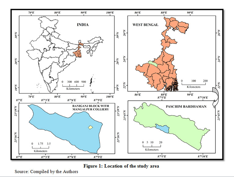 |
Figure 1: Location of the study area Click here to View Figure |
Objectives of the Study
The Main Objectives of the Present Study are As Follows
To detect the changing trend of land use and land cover in Raniganj coal belt, especially in Mangalpur opencast mining area.
To identify the nature of environmental risk in that region due to such change.
To suggest some sustainable measures to mitigate this problem.
Methodology and Data Sources
The present work is a combination of primary and secondary data analysis. A systematic methodology has been adapted to achieve the objectives (Fig 2). As this private colliery is a recently started activity in that region, its ill effects are still not very much exposed. But the associated environmental risk is very high as far as the perceptions of the authors are concerned.
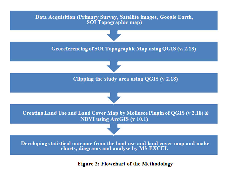 |
Figure 2: Flowchart of the Methodology |
Primary Data
For a proper understanding of current land use pattern of the area under study, frequent visit of the area is required. At first, the Mangalpur opencast colliery is surveyed with GPS receiver to get detailed locational information of the study area. GPS survey is also conducted after the secondary data processing for ground truth verification. Areas with land crack and subsidence are visited by the authors for field verification. Verbal interactions also have been done with the labourers and residents.
Secondary Data
Secondary data has been collected from various websites. Google earth layer is used to represent the conditions of Mangalpur colliery. For this, its boundary, collected by the GPS field survey has been plotted over the Google image as a polygon. To have a broad understanding of the land-use change and associated colliery activities, secondary data processing is done for the entire Raniganj block. From USGS site, Landsat-8 OLI/TIRS and Landsat-5 TM are collected with 30 m spatial resolution and from Survey of India’s nakshe portal topographical map number 73M/2 of 1967 (with scale 1:50,000) is downloaded. For a comparative study of land-use change in Mangalpur open cast colliery and entire Raniganj coal belt, Landsat-8 OLI/TIRS data sets are downloaded for the year 2013 and 2019 and on the other hand, Landsat-5 TM is downloaded for the year 2007. The present study area falls under path 139 and row 44 in the worldwide reference system of Landsat. Supervised image classification is done with QGIS (version 2.18) software using the mollusce plugin. To run the supervised classification the minimum distance algorithm has been used in the present study. There are various methods of change detection of land use and land cover.1 In the present study changes of land cover types have been compared to achieve the objectives. NDVI analysis is done to represent the change of vegetation cover in Raniganj area by ArcGIS software (version 10.1). In the end, a simple statistical analysis of available data developed to conclude the study.
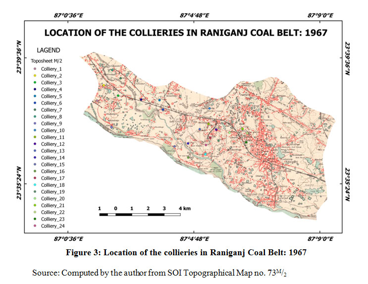 |
Figure 3: Location of the collieries in Raniganj Coal Belt: 1967 Click here to View Figure |
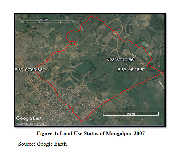 |
Figure 4: Land Use Status of Mangalpur 2007 Click here to View Figure |
Land Use Status of Mangalpur Colliery
Using Google Earth and ground-level GPS survey, changes of original land use pattern of the study area have been prepared. In the primary study area, i.e. Mangalpur, opencast private colliery activity was started in 2017. Before that, this area primarily was under agricultural practice, a little area was covered by the pond and rests were under vegetation, settlement etc. for a long period.
The map of 2019 shows that this study area is encroached by the opencast colliery. Frequency of water cover has been increased compared to the past two years map. The adjoining areas under agricultural activity at present is gradually being encroached by a coal mine and posing a threat to the local environment. As the coal mining area is located to proximity to a nursing school, high school, national highway, newly constructed multistoried building, dense human settlement etc. all of these are at great risk in the future.
 |
Figure 5: Land Use Status of Mangalpur 2013 Click here to View Figure |
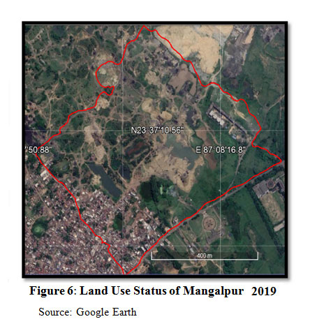 |
Figure 6: Land Use Status of Mangalpur 2019 |
Change in Land Use Pattern
In the land use and land cover maps of the study area, six distinct categories of land use patterns are identified. These are opencast mining, built-up area, vegetation, bare land, cropland, water body. Fig 7, 8 and 9 represent the sequential change of land use of the study area for three different periods viz. 2007, 2013 and 2019.
Changes in Vegetation Cover
Here a comparative study of Normalised Differential Vegetation Index (NDVI) map (Fig. 10) shows that dramatic change of vegetation cover across the study area during the period under consideration, ie. 2007, 2013 and 2019. Luxurious green vegetation contains chlorophyll in huge quantities, the substance which is responsible for the green colour of vegetation. The reduction in chlorophyll content over the earth surface results in a decrease in reflectance in the green wavelength. Phenology and vigour are the main factors that affect NDVI.
 |
Figure 7: Land Use and land Cover Map of Raniganj Block with Mangalpur Colliery, 2007 Click here to View Figure |
 |
Figure 8: Land Use and land Cover Map of Raniganj Block with Mangalpur Colliery, 2013 Click here to View Figure |
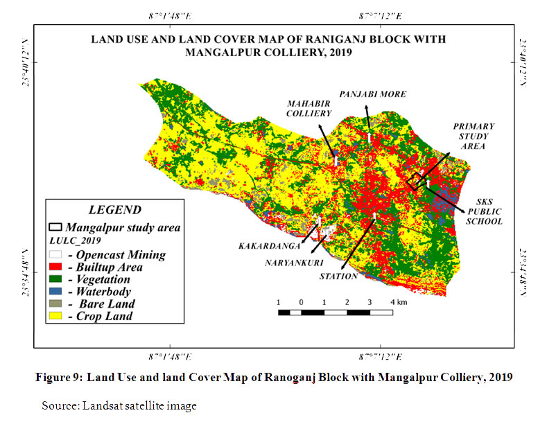 |
Figure 9: Land Use and land Cover Map of Raniganj Block with Mangalpur Colliery, 2019 Click here to View Figure |
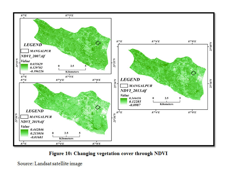 |
Figure 10: Changing vegetation cover through NDVI Click here to View Figure |
Here the darker areas have dry unproductive land with less accumulation of vegetation. Irrigated crop lands appear dark green in a real colour simulated image. In this NDVI analysis, it shows a negative change in vegetation cover from 2007 to 2019, mainly due to the sharp increase of colliery activities and also the development of new built-up areas as a result of rapid urbanization in this region. The white spots on the maps represent vegetation in fewer places. This gradual reduction in vegetation cover in the present study area and increase in opencast collieries is a serious matter of observation as far as the changing land use and land cover pattern of the area under study is concerned.
Analytical Findings
Temporal changes of land use categories during the specific period taken for the present study have been estimated hereby post-processing of image classification software. The comparison of various land use and land cover extents and their changes raise some important observations (Fig 11 and 12). The water body of the colliery area shows a growing trend from 2.91 per cent in 2007 to 3.08 per cent in 2019, though it was much higher in 2013 (3.24 per cent).
In 2007 the opencast colliery has covered an area of 0.23 per cent, which became 0.36 per cent in 2013 finally in 2019 the percentage of opencast colliery becomes to 1.06 per cent of the total study area. Hence it may be stated that the area of the opencast colliery in the study shows a constant increase in their areal extent. Its net change in areal extension is 1.37 per cent from 2007 to 2019. It has been observed that, with the advancement in mining and industrial activities, the various human occupancies of land for the residential, road network and other built-up purposes have also increased. The built-up area increased from 19.75 per cent in 2013 to 21.38 per cent in 2019.
It has been also noticed that vegetation cover has increased from 22.23 per cent in the year 2007 to 28.72 per cent in the year 2013 but it has been decreased drastically to 2.89 per cent in 2019. Cropland area has decreased from 50.01 per cent in 2007 to 41.26 per cent in 2019. The bare land area has increased drastically from 2013 to 2019. In the previous years, the area under that category was below 5 per cent, while in 2019 that category of land increased to 29.79 per cent. The land cover category under bare land net increased from 4.44 per cent in 2007 to 29.79 per cent in 2019.
The transition matrix explains the changes in different categories of land use in other categories. Here six types of land categories have been taken into consideration and the total amount of land under different categories has been considered as 1.000 for the year 2007 (Table: 1). In respect to that, total land under each category is represented for the year 2019. As a whole, it has been observed that total land under bare land (1.760), water body (1.568) and opencast mining (1.422) have increased.
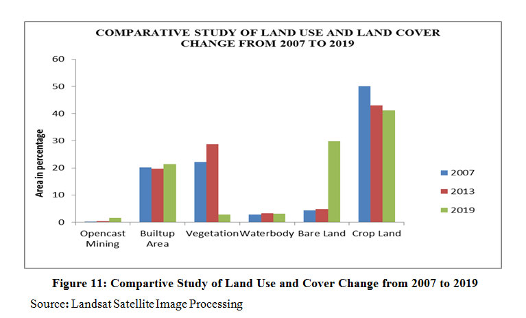 |
Figure 11: Compartive Study of Land Use and Cover Change from 2007 to 2019 Click here to View Figure |
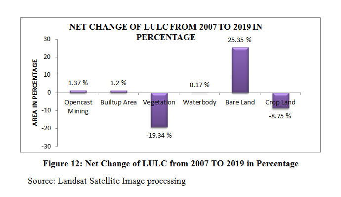 |
Figure 12: Net Change of LULC from 2007 to 2019 in percentage Click here to View Figure |
Table 1: Transition matrix of land-use change in the Raniganj coalfield area from 2007 to 2019 (sq.km)
|
Land use and Land cover classes |
Opencast Mining |
Built-up Area |
Vegetation |
Waterbody |
Bare Land |
Crop Land |
Total in 2007 |
|
Opencast Mining |
0.098 |
0.093 |
0.067 |
0.440 |
0.285 |
0.016 |
1.000 |
|
Builtup Area |
0.219 |
0.039 |
0.015 |
0.542 |
0.175 |
0.010 |
1.000 |
|
Vegetation |
0.689 |
0.023 |
0.012 |
0.115 |
0.157 |
0.006 |
1.000 |
|
Waterbody |
0.193 |
0.442 |
0.041 |
0.194 |
0.065 |
0.065 |
1.000 |
|
Bare Land |
0.037 |
0.016 |
0.049 |
0.145 |
0.437 |
0.317 |
1.000 |
|
Crop Land |
0.186 |
0.004 |
0.014 |
0.132 |
0.641 |
0.023 |
1.000 |
|
Total in 2019 |
1.422 |
0.617 |
0.198 |
1.568 |
1.76 |
0.437 |
6.000 |
On the contrary, land under built-up (0.617), vegetation (0.198) and crop (0.437) has decreased in 2019 compared to 2007. In Raniganj coal belt area, from 2007 to 2019 various types of land categories have been converted into opencast collieries. Among these, vegetation cover has the maximum share (0.689). A significant portion of the built-up area (0.219) and water body (0.193) has been engulfed by mining activities. Apart from these, few parts of arable land (0.186) and bare land (0.037) have been converted into such opencast coalfields.
Sustainable Management Plan
The government tries to mitigate the environmental impacts of mining through mined land rehabilitation programs. Mangalpur area in Raniganj is largely affected by unplanned mining activity. If an appropriate procedure is not be taken now, then it would not be possible to protect the environment of that region. So the following steps may be implemented there to achieve sustainable land use and land cover condition, these are:
Land Reclamation by Filling
The National Mineral policy pronounced in 1993 provides, interalia, that, ‘as far as possible reclamation and afforestation will proceed concurrently with mineral extraction’. After completing the opencast mining activity, the hole has to be filled with sand, dust, and clay.
Replacement of Soil
Soil quality in mining areas has been judged in various scientific studies recently, most of which were concentrated on the ecological and environmental impacts by coal mining and reclamation10. Topsoil has to be removed from the mining site and separately stockpiled for future use. Attention to be taken to protect it against erosion and degradation. The topsoil stockpiled separately is then replaced on mine spoils with the help of scrapers. Generally, a minimum of 15 cm of soil is to be replaced on mine spoils with the help of scrapers.
Afforestation
United Nations Framework Convention on Climate Change (UNFCCC) under the Kyoto Protocol recognized re-vegetation is a promising tool.10 After reclamation of the topsoil and land, then the next work, afforestation. The trees protect the soil from soil degradation, crack generation, land subsidence, etc.
Tillage Operation
Tillage operations help in developing the land conditions for the growth of vegetation on the top layer of soil. Tillage operation is useful for providing soil aeration, mixing fertilizer and mulches into the soil reducing compaction in the soil, facilitating moisture infiltration, and in providing good seed to soil contact.11 Native species of plants are most commonly used for ‘re-vegetation’. Because, these plants easily adopt the local climate.
Soil Amelioration
Soil amelioration activities are undertaken to overcome the adverse conditions including deficiencies of nutrients, presence of toxic compounds, poor texture and structure of soil and lack of organic matter. As Mangalpur is dominated by mining activity, vegetation is very scarce here. This operation is most important before re-vegetation practices. Biogas waste, compost etc. would be able to improve both the physical and chemical properties of degraded soil.11
Grazing
In Australia, grazing is a widely practised post-mining land use. In the present study area also, people may use the lands of abandoned collieries as pasture land. Grazing may also be practised as a use suited to rehabilitated mined land because of the lower land productivity required compared to cropping.12 This process has no negative effect on the environment.
Underground Mining Instead of Opencast Mining
Underground mining is much better than opencast mining. Because, it does not affect the surface land uses like agricultural practice, grazing etc. But opencast mining activity ruins the surface land. No other use can be done on that land. So, underground mining activity is more welcome one, both in terms of environmental as well as economic interest.
If these processes are followed, it is sure that many environmental problems may be reduced and a sustainable way of land use practice will be achieved.
Conclusion
Coal production in Raniganj coalfield was increased 15.80 million tons in 2002–03 to 30.084 million tons in 2011–12. That enhancement in production was mainly achieved by increasing the extent of opencast projects primarily. That resulted in severe topographic deformation. Such unplanned and vulnerable activity is also increasing and the depth of opencast quarry, which is also increasing day by day. To combat this problem, proper backfilling of exhausted collieries should be made mandatory. Apart from that, overburden spoil generated from colliery activity should be dumped with a well-planned way to restrict the release of toxic elements.13
Considering the entire scenario, it may be stated that land use of the primary study area, ie, of Mangalpur, drastically changing due to opencast mining activity. In 2007 and 2013, this area was dominated by agricultural land use but at present, this area is under private coalfield. As a result of this, economic profit is increasing rapidly, but at the cost of deteriorating the water and soil quality, loss of biodiversity and increasing the risk of the human living environment. The environmental condition of the study area is gradually becoming worse. There is a necessity for a sustainable development plan for the region and its proper implementation is required.
Such study at micro-level may be helpful to manage the land use of the colliery region effectively. But using the satellite image of 30-metre spatial resolution for a small colliery like Mangalpur, having an area of 386,472 square metres only, is not sufficient. This is also a limitation of the present study. Application of satellite images with higher spatial resolution would provide a better result for such research works in future.
Acknowledgement
We are grateful to the local authority and workers of the Mangalpur Colliery, Raniganj for allowing us to conduct geospatial survey for the present study. The post-graduation department of Geography, Triveni Devi Bhalotia College, Raniganj also deserves special thanks for providing moral support and infrastructures like GIS Lab, GPS devices etc. for this work.
Funding
The author(s) received no financial support for the research, authorship, and/or publication of this article.
Conflict of Interest
The authors do not have any conflict of interest.
References
- Boakye E, Odai S. N, Adjei K. A, Annor F.O. Landsat images for assessment of the impact of land use and land cover changes on the Barekese catchment in Ghana, European Journal of Scientific Research, 2008; 2: 617–626.
- Prakash A, Gupta R. P. Land-use mapping and change detection in a coal mining area – a case study in the Jhariacoalfield, India, International Journal of Remote Sensing. 1998;19(3): 391-410 DOI:10.1080/014311698216053.
- Majumder B. Land use and land cover change detection study at Sukida valley using Remote Sensing and GIS, B Tech thesis, Department of Mining Engineering, National Institute of Technology, Rourkela, India. 2011
- Eastern Coalfields Raniganj coal mines. Global Energy Monitor. Wiki. https://www.gem.wiki/Eastern_Coalfields_Raniganj_coal_mines. 2015. 25/12/2019. 12/01/2020.
- Garai D, Narayana A. C. Land use/land cover changes in the mining area of Godavari coal fields of southern India, The Egyptian Journal of Remote Sensing and Space Sciences, 2018; 21: 375-381. DOI:10.1016/j.ejrs.2018.01.002
- Samanta P. Impact Assessment and Changes Analysis of Land Use/ Land Cover Due to Open Cast Coal Mining Activity: A Case Study of Raniganj Coal Field Area, International Journal of IT, Engineering and Applied Sciences Research, 2015; 4(5): 17– 27.
- Areendran G.Rao, P. Raj, K. Mazumdar, S. Puri K. Land use/land cover change dynamics analysis in mining areas of Singrauli district in Madhya Pradesh, India, International Society for Tropical Ecology, 2013; 54(2): 239-250.
- Shankar U, Boral L, Pandey H N and Tripathi R S. Degradation of land due to coal mining and its natural recovery pattern, Current Science Association, 1993; 65(9): 680-687.
- Limpitlaw D, Aken M, Lodewijks H, Viljoen J. Post-mining rehabilitation, land use and pollution at collieries in South Africa, The South African Institute of Mining and Metallurgy, presented at the Colloquium: Sustainable Development in the Life of Coal Mining; 13/07/2005; Boksburg.
- Dejun Y, Zhengfu B, Shaogang L. Impact on soil physical qualities by the subsidence of coal mining: a case study in Western China. Environ Earth Science, 2016; 75(652): 1-14. DOI:10.1007/s12665-016-5439-2
- Agus C, Wulandari D, Primananda1 E, Hendryan A, Harianja V. The Role of Soil Amendment on Tropical Post Tin Mining Area in Bangka Island Indonesia for Dignified and Sustainable Environment and Life, C Agus et al 2017 IOP Conference Series.: Earth Environ. Sci, 2017; DOI:10.1088/1755-1315/83/1/012030P
- Maczkowiack R.I, Smith C.S, Slaughter G. J, Mulligan D.R, Cameron, D.C. Grazing as a post-mining land use: A conceptual model of the risk factors, Agricultural System, Elsevier, 2012; 109: 76-89.
- Manna A, Maiti R. Opencast Coal Mining Induced Defaced Topography of Raniganj Coalfield in India - Remote Sensing and GIS Based Analysis, Journal of Indian Society of Remote Sensing, 2014; DOI 10.1007/s12524-014-0363-y


