Planning of Conservation Measures for Watershed Management and Development by Using Geospatial Technology – A Case Study of Patur Watershed in Akola District of Maharashtra
R. S. Patode 1
, C.B. Pande 1
*
 , M. B. Nagdeve 1
, K. N. Moharir 2
and R. M. Wankhade 3
, M. B. Nagdeve 1
, K. N. Moharir 2
and R. M. Wankhade 3
1
AICRP for Dryland Agriculture,
Dr. Panjabrao Deshmukh Krishi Vidyapeeth,
Akola,
Maharashtra,
India
2
Department of Geology,
Sant Gadge Baba Amravati University,
Amravati,
Maharashtra,
India
3
Department of Agricultural,
Dr. Rajendra Gode College of Agriculture,
Buldhana,
Maharashtra,
India
http://dx.doi.org/10.12944/CWE.12.3.22
Copy the following to cite this article:
Patode R. S, Pande C. B, Nagdeve M. B, Moharir K. N, Wankhade R. M. Planning of Conservation Measures for Watershed Management and Development by Using Geospatial Technology – A Case Study of Patur Watershed in Akola District of Maharashtra. Curr World Environ 2017;12(3). DOI:http://dx.doi.org/10.12944/CWE.12.3.22
Copy the following to cite this URL:
Patode R. S, Pande C. B, Nagdeve M. B, Moharir K. N, Wankhade R. M. Planning of Conservation Measures for Watershed Management and Development by Using Geospatial Technology – A Case Study of Patur Watershed in Akola District of Maharashtra. Curr World Environ 2017;12(3). Available from: http://www.cwejournal.org?p=1058/
Download article (pdf)
Citation Manager
Publish History
Introduction
A watershed is defined as natural Hydrologic unit that covers a precise area of land surface from which rainfall in the form of runoff flows to a definite drainage, stream or river at any point.1,14 Watersheds are hydrologic units considered to be efficient and suitable for the assessment of accessible resources within an area thus influencing subsequent planning and implementation of different development programs within that area. Hence, all the necessary natural resources inside a watershed area such as soil, water and vegetation in the hydrological entity of a watershed area should be managed sustainably.7 The ecological and growth problems were calculated which are the most important drivers of human welfare on the Earth surface. These two aspects are responsible for human being benefits in conditions of affluence and survival. This is mostly because human survival is an immediate objective and therefore ‘an urgent’ issue and environment takes time to show ‘stress’ – but really threatens the very human survival that ‘human greed’ tries to address in short term development. There is a struggle between general productivity and hence on economic development and environmental ‘health’ sustainability. In rising economies, about 82% of people reside in the rural areas and depend on the natural resources of land and water for day-to-day livelihood.8 The study of population blast in rural part tempered with restricted information on agricultural ‘good practices’ implies more land degradation, higher poverty levels and health problems. This situation demands for prudent management of available resources, both natural and man-made, especially watersheds and wetlands. The capability of GIS and Remote Sensing technologies in data capture, storage, analysis/querying and displaying has proved to be fast, accurate and cheap thus useful tools for environmental conservation and management.6 Watershed development and management is an iterative procedure of integrated decision creation about uses and change of lands and waters inside a watershed. Development of the watershed wants better understanding regarding the different natural resources their relations with each other and their relations with livelihood of the stakeholders.15 The present study is delineated by Geospatial technology to propose different conservation structures and rainwater harvesting activity in order to propose watershed development plan for Patur watershed covering 3857.99 (Ha) of the Akola district in the Maharashtra state of India.
Study Area
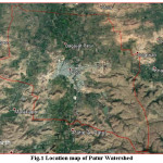
The study area is situated by South latitudes 20030’0” to 20025’30” and East longitudes 76053’30” to 7700’30” falls in the Patur Taluka at Akola district in Maharashtra and covered by Survey of India toposheet no. with scale of 1: 50000. The Average annual rainfall of the area is about 750 to 850 mm. The mean maximum and minimum temperatures 42.3ºC and 11.8ºC were observed in the watershed area respectively. Location of watershed area is shown in Figure 1.
 |
|
Methodology
In this study procedure was adopted for planning of conservation measures for watershed development plan. The satellite images data 2017 were downloaded from the National Remote Sensing Center.16 To escape spectral confusions and errors in change detection, satellite images taken in similar periods had to be selected; hence, satellite images have been acquired in the month of March and April for natural resource mapping. These periods were selected due to the fact that the area receives rainfall from monsoon only during June to October and during this period ground coverage due to vegetation is more and the catchment waterways location may not be visible clearly. For the watershed development plan satellite images, topographical maps, DEM data and other collateral data of the Patur watershed area was used. The topographical maps and geological maps were geo-rectified using spatial analysis tools. These satellite images (Red, Green and Blue) were processed through image processing software like ERDAS and Arc GIS software 10.3. The watershed area map was delineated from DEM data with 30 m using Arc Hydro Tools software. The land use features were demarcated from satellite images using supervised classification. The geology map was prepared from satellite images and geological maps with the help of geospatial technology. The geological map is very important in watershed development and management plan. The geomorphology features were demarcated with the help of visual interpretation techniques with the reference of topographical maps. These geomorphology features were digitized in the geographic information system software. Slope map for the study area was prepared using digital elevation model (30 m), satellite images and Arc Hydro Tools in GIS system. These thematic layers were integrated using geospatial technology for development of watershed activity such as recharge wells, farm ponds, CNB, gully plug and CCT.2 and 4
 |
|
Results and Discussion
The Patur watershed area comes under dryland condition with the Deccan trap (Basalt Rock) and undulating topography. Number of case studies and soil and water conservation projects proved unsuccessful sometime due to improper watershed development plan and due to adjustments with dissimilar facets of environment problems by lack of awareness of the soil, water and other resources in the micro-watershed planning. In order to make finest use of existing environmental resources like land, soil, forest, vegetation and water in watershed, systematic scientific surveys must be conducted. Geo-spatial studies of the hard rock terrain, socioeconomic assessment of the stake holders and the use of remote sensing and GIS data for earlier appraisal of environmental resources such as hydrology, soil, geology, land use and land cover, soil fertility, soil land capability and drainage density as well as evaluation of cost-effective activities through land use and infrastructure of the watershed area is well known information. The remote sensing data and GIS software is a very powerful tool for development plan of the watershed area with whole environmental and socioeconomic factor for good planning, implementation and monitoring of any watershed area. Remote Sensing (RS) data and Geographical Information System (GIS) play key role in the sector of sustainable water resource development and management (Carlos Perez et al. 2003). One of the best advantages of using remote sensing data for natural resource management is its capability to make the information in spatial and temporal domain, which is very critical for successful model analysis, prediction and validation.
Watershed Development Policy Analysis and Support
The field of watershed science, particularly watershed planning is experiencing fundamental changes that are having profound impact on the use of computer-based simulation models in natural resource development, planning and management.5 However, the use of technology and other software cannot serve all the requirements of development, planning and managing watersheds. This realization has improved resource planners’ interest in development of decision support systems that come together watershed modeling software, GIS, spatial and non spatial data, computer-based biophysical models, knowledge based (expert) systems, and sophisticated visualization technology into integrated systems to support planning and policy analysis functions.13
Land Use/ Land Cover
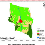
The land use/land cover classes such as agriculture, built up, forest, wastelands and water body, wasteland and forest lands were identified from satellite images (30 m resolution) using unsupervised classification with the visual interpretation elements in the GIS environment and depicted in Figure 2. In this study, about 60.26, 1.82, 15.86, 20.94 and 1.12 % of the areas are covered by Agricultural, Built-up land, Forest, Wastelands and Water body (Table 1). In this watershed most of the people utilize the land for agricultural purposes. This current study area was covered by dense forest with hilly terrain area. This study proves that integration of GIS and remote sensing technologies are very effective tools for land use classes and also for preparing watershed development plan.12,16 and 10
 |
|
Table 1: Area covered in Land use classes of the Patur watershed
|
Sr. No. |
Land use classes |
Area Covered (Ha.) |
Area (%) |
|
1. |
Agricultural |
2324.82 |
60.26 |
|
2. |
Built-up |
70.21 |
1.82 |
|
3. |
Forest |
611.65 |
15.86 |
|
4. |
Wastelands |
808.06 |
20.94 |
|
5. |
Water body |
43.23 |
1.12 |
|
Total |
3857.99 |
100 |
Geology and Geomorphologic Study
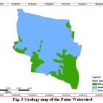
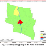
The geological study is necessary for preparation of watershed and groundwater development plans. The geology map was prepared using satellite images by verifying with the ground truth. The soil and water conservation structures are varying from rock to rock at the watershed level. The identification of geology features are cross checked by ground data with photograph. During survey of Patur watershed key role of geology is observed for increasing groundwater depth. Therefore three major crops like Soybean, Cotton and Pigeon-pea were observed in the Patur watershed. These maximum agricultural lands are depending upon rainfall and also maximum agricultural land is not cultivated during other seasons because groundwater table condition is very low during month of October to May. This study consists of two types of rock such as Massive and Vesicular basalt rocks under in Deccan trap region. The Vesicular basalt rock is most favorable zone for water conservation structures and groundwater exploration activity. The Massive basalt rock is not suitable region for groundwater exploration because due to the very hard rock with compact basalt (Fig.3). Geomorphology is the study of different landforms using remote sensing data. Landforms play a significant role in the water and land resources mapping, watershed development study, terrain evaluation and soil types in addition to groundwater studies.11 The groundwater conditions are different from terrain to terrain. For the present study IRS P6 LISS-III (2017) satellite imagery and SOI Toposheet having scale of 1: 25000 was used and different geomorphic features like Alluvial plain, Plateau, Built-up and Water body land was mapped (Fig. 4). Based on the interpretation of the satellite imagery and SOI toposheet alluvial plain area is observed with saline water surrounding the watershed due to lots of sediment deposition and chemical content. The saline water problem may be overcome due to implementation of soil and water conservation development plan. The horizontal dispositions of the basaltic lava flows with a fair degree of uniformity in lithology the changes may be resulted due to the secondary processes like rock weathering and denudation hills [9]. Differential weathering forces have resulted in wiping out of thick lava pile. The result of geomorphic analysis shows the control of rock erosional land forms over the depositional landforms. The study area can be interpreted as a moderate morphogenetic and basaltic rocks region.
 |
|
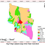
Slope Analysis
Slope analysis is a significant criterion based on which the land and water resource development plan through use of geospatial technology can be prepared. The watershed area sometimes observed with the high runoff and rainfall due to hilly and dense forest area. A higher degree value of slope results in a high run-off potential in the Patur watershed area. The slope map was demarcated by using digital elevation model with contour data in Arc GIS 10.3 software, where in slope category of 1-3 and 3-5% will have low runoff, the area having slope range of 5-10% will have moderate runoff, the area having slope range of 10-15% will have high runoff and the area with 15-35% slope will have very high runoff. However the total contribution of the runoff will depend on the area coverage in particular class in the watershed. Here maximum area coverage is being observed up to 5% slope followed by up to 10% slope category. The area coverage in higher slope categories is observed less as compared to lower slope categories (Fig. 5 and Table 2).
Planning of conservation Measures for watershed development
From the slope analysis given in Fig. 5 it was clear that the maximum area of the watershed is having slope less than 3%, where normal cultivation can be done along with in-situ conservation practices for soil and water conservation which can be beneficial to agronomic field crops and will be useful for groundwater recharge. The CNB and farm ponds can be constructed for rainwater harvesting and judicial use of conserved water. The area having slope more than 3 % and less than 5 % will have to be treated with conservation practices along with temporary (Gully Plug/LBS/ENB) and semi permanent (Gabion) soil and water conservation structures at appropriate drainage lines.
The area having 5 to 10 % slope will not be useful for agronomic practices where contour trenches are useful for rainwater conservation. On drainage lines CNB can be constructed for rainwater storage. In the area having more than 10 % slope aforestation activities on large scale can be taken up along with permanent structures for rainwater harvesting.
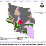
On the basis of this slope analysis and activities to be undertaken the proposed plan for Patur watershed development is presented in Fig.6. The suitable temporary, semi- permanent and permanent structures were proposed in the plan. Based on this map the activities can be implemented and due to which the groundwater augmentation is possible which will be beneficial for increasing the water table in this area and may ultimately solve the water related crises in the area.
 |
|
Table 2: Different Slope values of the Patur watershed
|
Sr. No. |
Slope Values (%) |
Area Covered (Ha.) |
Area (%) |
|
1. |
1-3 |
1990.20 |
51.59 |
|
2. |
3-5 |
690.60 |
17.90 |
|
3. |
5-10 |
719.34 |
18.65 |
|
4. |
10-15 |
23.48 |
0.61 |
|
5. |
15-35 |
320.91 |
8.32 |
|
6. |
Built-up Land |
70.23 |
1.82 |
|
7. |
Water Body |
43.23 |
1.12 |
|
Total |
3857.99 |
100 |
 |
|
Conclusion
The Patur watershed area with very undulating slopes tending towards North direction and elevations of 270 to 480 m above mean sea level is drained by many streamlets. Therefore by taking into consideration the slope as per the plan provided different in-situ soil and water conservation practices should be adopted along with construction of temporary, semi-permanent and permanent structures on the drainage lines for harvesting the runoff from rainwater. This will also be useful for augmenting groundwater recharge which ultimately will lead to increase in the groundwater levels further providing extra irrigation during Kharif and Rabi season. The watershed development plan can be used in the watershed area, to direct impact of groundwater levels, crop yield and production of the Patur watershed. The Patur taluka is source of river in the Akola and Buldhana districts. Afforestation activities along with CCTs and permanent structures may be adopted on greater sloped areas. This watershed development plan will be useful to farmers and they may be benefitted by adoption of one or combination of these activities as per site suitability.
Acknowledgment
We are grateful towards Chief Scientist, All India Coordinated Research Project for Dryland Agriculture, Dr. Panjabrao Deshmukh Krishi Vidyapeeth, Akola (Agricultural University) for providing the necessary facilities and financial support for conducting this research.
References
- Abel Nyaribo Kaburi and Patroba Achola Odera. GIS and Remote Sensing Support in Watershed Conservation and Management: Case Study of the Upper Gucha Watershed – Kenya, IOSR Journal of Environmental Science, Toxicology and Food Technology, 8.7: 35-43, (2014).
- Biswas, S. Remote sensing and geographic information system bases approach for watershed conservation. J. Surv. Eng., 128: 108–124, (2002).
CrossRef - Carlos Perez and Henry Tschinkel. Improving Watershed Management In Developing Countries: A Framework For Prioritising Sites and Practices, Agricultural Research & Extension Network, (2003).
- Chaitanya B. Pande, S. F. R. Khadri, Kanak N. Moharir R. S. Patode. Assessment of groundwater potential zonation of Mahesh River basin Akola and Buldhana districts, Maharashtra, India using remote sensing and GIS techniques, Sustainable Water Resources Management, 1–15, (2017).
- Chakraborti, A. K. Strategies for watershed management planning using remote sensing techniques. J. Indian Soc. Remote Sensing, 22: 87–97, (1993).
CrossRef - Chang K. T., Introduction to Geographic Information Systems. Mc Graw-Hill Co. (2009).
- Palanisamia and D. Suresh Kumar B. Impacts of Watershed Development Programmes: Experiences and Evidences from Tamil Nadu, Agricultural Economics Research Review, 22: 387-396, (2009).
- Karanjit S. Remote Sensing and GIS in Watershed Area Management; Free Lance Environmental Consultant and Part time Trainer; Institute of Environmental Management. Nepal, (1998).
- Khadri, S. F. R., Chaitanya B. Pande. Remote Sensing and GIS Applications of Geo-morphological Mapping of Mahesh River Basin, Akola & Buldhana Districts, Maharashtra, India using Multispectral Satellite Data, Indian Streams Research Journal, 4.5, (2014).
- Khadri S.F.R., Kanak Moharir. Land use/cover disturbance due to increase in urbanization Man River Basin of Akola Buldhana Districts, Maharashtra-India: A remote sensing and GIS based approach, Compusoft, An International Journal of Advanced Computer Technology, 5: 211, (2016).
- Khadri S.F.R., Kanak Moharir. Characterization of aquifer parameter in basaltic hard rock region through pumping test methods: a case study of Man River basin in Akola and Buldhana Districts Maharashtra India, Modeling Earth Systems and Environment, 2.1, 1-18, (2016).
CrossRef - S. Patode, M. B. Nagdeve, C. B. Pande and K. N. Moharir, Land use and land cover changes in Devdari Watershed, Trends in Biosciences Vol. 10.8: 1622-1625, (2017).
- Sharma, B.R. and Scott, C.A. Watershed management challenges: Introduction and overview, In: Watershed Management Challenges: Improving Productivity, Resources and Livelihoods. Eds: B.R. Sharma, J.S. Samra, C.A. Scott and S.P. Wani, International Water Management Institute (IWMI) and International Crop Research Institute for Semiarid Tropics (ICRISAT) publication. Malhotra Publishing House, New Delhi, 245-257, (2005).
- Integrated Water Resource Management Definition; International Decade for Action ‘WATER FOR LIFE’ 2005 -2015, (2009).
- Vinayak N. Mangrule and Umesh J. Kahalekar. Watershed Planning and Development Plan by Using RS and GIS of Khultabad Taluka of Aurangabad District, International Journal of Information and Computation Technology, 3.10: 1093-1100, (2013).
- Pande C. and Moharir K. N. (2014) Analysis of Land Use/Land Cover Changes Using Remote Sensing Data And GIS Techniques of Patur Taluka, Maharashtra, India, IJPRET, 2.12: 85-92, (2014).
- http://www.bhuvan.com).


