Rainfall Variability in Chhattisgarh State Using GIS
Sanjay Bhelawe1 * , J. L. Chaudhary1 , A. S. Nain1 , R. Singh1 , Rajesh Khavse1 and S.K. Chandrawanshi *
1
Department of Agrometeorology,
Indira Gandhi Krishi Vishwa Vidyalaya,
Krishak Nagar,
Raipur,
494 005
Chhattisgarh
India
http://dx.doi.org/10.12944/CWE.9.2.36
Copy the following to cite this article:
Bhelawe S, Chaudhary J. L, Nain A. S, Singh R, Khavse R, Chandrawanshi S. K. Rainfall Variability in Chhattisgarh State Using GIS. Curr World Environ 2014;9 (2) DOI:http://dx.doi.org/10.12944/CWE.9.2.36
Copy the following to cite this URL:
Bhelawe S, Chaudhary J. L, Nain A. S, Singh R, Khavse R, Chandrawanshi S. K. Rainfall Variability in Chhattisgarh State Using GIS. Curr World Environ 2014;9(2). Available from: http://www.cwejournal.org/?p=6610
Download article (pdf) Citation Manager Publish History
In India despite recent progress in industrlization, the soundness of economy is significantly dependant upon the gross production of agricultural commodities and agriculture is the mainstay of millions of teeming population with crops pre-dominantly dependant upon natural rainfall. Excepting the south-eastern part of the peninsula and Jammu and Kashmir, the south west monsoon (June – Sept.) is the principle source of rain in the entire country. During monsoonal period more than 75% of annual rainfall is received over a major portion of the country. India’s economy has traditionally been agricultural in nature and excess climate anomalies, deficient and flooded rainfall years have a dramatic impact on the economy as well as on the living conditions of the inhabitants of the affected regions (Parthasarthy et al. 1988). The green revolution on technology has increased the rice production and productivity substantially. However, the sustainability of rice based system is threatened due to
- The insufficient use of inputs
- Scarcity of resources especially water and labour
- Changing climate
- Rising cost of cultivation
- Emerging source of economic change
As changing climate and erratic distribution of rainfall and increased field water losses account for unreliability and shortage of water for crop production, here stress has been laid on regional climate change. Most of precipitation occurs between June to September and during this period about 50% of rainfall occurs in about 20-30 hours (Pishroty, 1987). This duration hardly accounts for 1% of total rainy season during which rainfed rice is grown. A large amount of water from these storms is lost by runoff, seepage and percolation.
According to Gates (1988), experience of the world is sufficient to convince people that even a temporary change of climate can have profound impact on agricultural production and on the use of energy and water resources. Water stresses are a common feature during growth cycle of crops. Although water in form of precipitation is availble freely and right at the site where it is to be used, yet so tenuous and delicate is the balance between the demand for water by crops and its supply by precipitation that even short term deficit periods often reduce the production significantly (Gupta et al. 1990). Interpretation of climatic variables is essential because of these variations (Subramaniam and Raju, 1988).
Chhattisgarh state, situated in eastern India stretches between 80Ëš15′ to 84Ëš24′ E longitude & 17Ëš46′ to 24Ëš 5′ N latitude. It covers total geographical area of about 13.5 million hectare. Rice crop is grown in 3.7 million hectares and rainfed rice production has always remained a challenge in this region. This state has three agro climatic zones viz., Chhattisgarh plains, Bastar plateau and Northern hills region. Its climate is of dry sub-humid type. Under wide range of farming situations and soil conditions, except upland light soil, rice is widely accepted and grown by the farmers depending upon their socio-economic conditions. During kharif, growing of rice is a tradition and is widely accepted depending upon farmers socio-economic conditions. While, in rabi, there are fewer options for the stakeholders to take profitable and/or suitable crops. Under these circumstances, they generally follow rice – wheat, rice – mustard and rice – winter vegetables under partially or assured irrigation and rice- fallow, rice – utera (Lathyrus, chickpea and linseed) under rainfed situation.
Rainfall analysis is important in view of crop planning for any region. In order to stabilize crop yield at reasonable levels in rainfed situation, it is essential to plan rainfed crops and their management practices in consonance with the rainfall pattern prevalent in the region. Rainfall studies, particularly its variability and probability analysis give more information for rainfed crop planning. Among the climatic elements the rainfall is the first index, ever thought of by farmers and climatic analyzers as it is the most important single factor which determines the cropping pattern of an area in general and the type of crop to be cultivated and its success or failure in particular. The study of rainfall pattern is very important for the agricultural planning of any region. Monsoon depressions and cyclonic storms are the most important synoptic scale disturbances which play a vital role in the space– time distribution of rainfall over India (Sikka, 1977).All of the natural conditions, rainfall should be regarded as the fundamentals so for as progress of the society is concerned. Rainfall is a crucial agroclimatological factor in the seasonally arid parts of the world and its analysis an important perquisite for agricultural planning in India (Gadgil 1986). India is a tropical country its agricultural planning and utilization water is depends on monsoon rainfall, more than 75% of rainfall accruing during the monsoon season; monsoon rainfall is uneven both in time and space, so it is important factors to evolving the rainfall analysis. Jagannadha sarma (2005) has analysed the rainfall pattern of the coastal zone of Krishana Godavary River Basin Andhra Pradesh, India. He has made analysed the annual, monsoon and non-monsoon rainfall and spatial and frequency distribution of rainfall intensity and Vennila (2007) has analysed rainfall variation analysis of Vattamalaikarai subbasin, Tamil Nadu, India by interpreting monthly, seasonal variation, intensity and frequency of rainfall.
Daily rainfall and rainfall on different timescale plays a great role in weather phenomena in tropical countries and helps to determine the agricultural land use potential and hydrological investigations. Further, a precise understanding of agro -climatic conditions is a pre-requisite for efficient crop planning in any given region. This type of understanding is of more relevance in rainfed area where crop productions depend on vagaries of monsoon and other climatic parameters. Therefore rainfall distribution pattern is a major determinant of crop yield in rainfed areas. In this context, collection, scrutiny and analysis of historical weather data available in the region are essential to characterize the agricultural climate of the region.
Materials and Methods
Data Base Used
Various data sets of Chhattisgarh state were used during the study course. The basic data, which were collected and used during the work, were: Soil type, soil depth, soil physiography, digital elevation map, temperature, precipitation, length of growing period, land use land cover map, administrative boundary, available water capacity . These preliminary data were collected by visiting various areas concerned of the state. The very first data collected was the maps related to soil resource of Chhattisgarh. Such map includes maps showing the soil type, soil depth and soil physiography of the state. These soil resource maps were than digitized to prepare the digital soil resource database. The second most important parameters which were collected includes the different meteorological data like rainfall and temperature data from different meteorological stations where the visiting was done for the data collection. The stations visited for the data collection were:
- Revenue department of Chhattisgarh
- College of agriculture Raipur, Bilaspur, Ambikapur, and Jagdalpure.
For the computation of water balance of different parts of Chhattisgarh, the rainfall data for those areas as well as, temperature data, humidity data, wind speed data, radiation data of the related areas were also collected. Apart from all these data the land use land cover map of the Chhattisgarh state was also collected. And last but not the least, SRTM (Shuttle Radar Topography Mission) data of the state for DEM generation were also collected.
Data Generation
The weather data of recent 30 years. The spatial surface of the rainfall data was generated in ARC-view 3.1 GIS software using the Inverse Distance Weigtage (IDW) algorithm. We used 0.0150 pixel during mapping. All the primary maps of Chhattisgarh which were collected were geo referenced and digitized using ARC-view 3.1 GIS software.
Results and Discussion
The spatial surface of the rainfall data was generated in ARC-View 3.1 GIS software using the IDW (Inverse Distance Weightage) algorithm.
Annual Average Rainfall
The entire state has been divided in to five major categories (Fig. 1) namely very high rainfall zone (rainfall >1600 mm), high rainfall zone (1500-1600 mm), medium rainfall zone (1400-1500), low rainfall zone (1300-1400) and very low rainfall zone (<1300mm). The spatial distribution of rainfall shows that south Easter Bastar region comprising of some part of Jagdalpur and Dantewara, eastern part of northern hills zones comprising of most part of Jashpur and some part of Sarguja and north eastern parts of Chhattisgarh plains zone comprising of most part of Raigarh and some part of Janjgir, Raipur and Mahasamund receive high to very high rainfall. The reason being that in these part of state the onset of monsoon is bit early than other parts of the state, thus monsoon remains active for longer period in these part. Other regions contributing of high rainfall can be the thick forest cover and orographic sector of rainfall due to undulating area. The whole districts of Bijapur and parts of Dantewara, Narayanpur, Jagdalpur, Koriya, Sarguja, Korba, Bilaspur, Janjgir, Raipur, Mahasamund, and Raigarh receive medium rainfall, while other part of the state which mainly include the Chhattisgarh plains zone and some parts of Bastar plateau and northern hills zone receive low rainfall due to the various factors such as distance from bay of Bengal, rainfall shadow effect availability of orographic lifting being plain zone. A small geographical region consisting of central Raipur and Durg receive very low rainfall due to the higher degree of urbanization.
Rainfall During Kharif Season
Maximum rainfall occurrence in the state falls in between July to September months of the year, which includes kharif season (Fig. 2). As like Average annual rainfall, sate has been divided into 5 major categories namely very high rainfall zone (>1525 mm), high rainfall zone (1450-1525 mm), medium rainfall zone (1375-1525), low rainfall zone (1300-1375) and very low rainfall zone (<1300mm).
During Kharif season spatial distribution of rainfall shows that eastern part of northern hill zone comprising head quarter of Jashpur district and its surrounding area. The reason is that, due to hilly region onset of monsoon is early and also active mainly during Kharif season, made to get maximum rainfall during this season.
The maximum area of northern hilly zone like Surguja, Jashpur and north eastern part of Chhattisgarh plains zone like Raigarh and some part of Janjgir receives high rainfall where as large part of Bastar plateau comprising Jagdalpur, Bastar and part of Dantewara includes Barsur, Gidam, Karka, Koleng. Parts of northern hill zone like Sarguja comprising Ramanujganj, Tattapani, Lundra, Sitapur and Jashpur includes Kunkuri, Mahnai, Pathalgaon, and Kotaba. Maximum part of Chhattisgarh plain comprising part of Raigarh like Dharmjaygarh, Bhojpur, Lailunga and Sakti, Jaijapur, Nawagarh of Janjgir Champa. Part of Bilaigarh, Tala, Sirsiwa of Raipur district and also Saraipali and Basna block of Mahasamund district comes under medium rainfall area.
Most part of Bastar platue like Dantewara, Middle part of Jagdalpur and Makri, Kondagaon, Narayanpur, Sonpur, Chitrakote of Narayanpur districts receives low rainfall during Kharif. Most part of Korea and Sarguja district Middle part of Korba includes Pali, Katghora, Korba; Kendai also comes under this group. West part of Janjgir, East part of Bilaspur comprising Baloda, Akaltara, Pamgarh, Bilha, Bilaspur, Ratanpur, Kota and areas like Kasdol Balodabazar Bhatapara Palari which are the part of Raipur and Patewa, Pithora and Bagbahra of Mahasamund district comes under this category.
Kawardha, Rajnandgao, Durg, Kanker, Dhamtari, More than 60% area of Raipur (Sigma, Tilda, Abhanpur, Rajim, Gariaband, Deobhog, Chhura), Mahasamund (Sirpur and Mahasamund) and Korba (Pasan and Ahirpara) of Chhattisgarh plain, Northern Jagdalpur and Narayanpur (Keskal, Paralkot and Koylibera) of Bastar Plateau and Korea of Northern hill zone come under very low rain fall category.
Rainfall during Rabi Season
As mentioned above maximum rainfall of the state occurs in Kharif season, rainfall during Rabi season only ranges between 80 mm to 160 mms. Most part of Chhattisgarh plain, northern hill zone and northern part of Bastar plateau falls under very low rainfall (< 85 mm) during Rabi season (Fig. 3). Maximum part of western part of Northern hill zone, some part of south east and south west region of Sarguja and Jashpur district and some pats of Chhattisgarh plain comprises Near about 50% of Korba(Pali, Katghora and Piparia) and parts of Bilaspur (Achanakmar, Lormi, Kota, Tkhatpur and Ratanpur), Kawardha (Pandaria), Mahasamund (Bagbahra and Suarmar), Raipur (Chhura, Gariaband, Rasela and Mainpur), Rajnandgao (Dogergaon, Ambagarh chauki, Mohala and Manpur), Durg (Dhallirajhara and Dondi), Dhamtari (Siphonpara and Nagri), Kanker (Antagarh and Bhanupratappur) comes under low rainfall (85-100 mm) also including some parts of Bastar plateau like Jagdalpur (Parasgaon and Dongar) and Koylibera of Narayanpur district. Eastern part of Northern hill zone and parts of Chhattisgarh plain comprising of Bilaspur (Pendraroad, Parasi, Keonchi, Kotmei and Marvahi), southern Raipur, Pasan part of Korba, Dhamtari (Bora, Umargao and Parasgaon) and Kanker (Pakhanjur) and maximum part of Bastar plateau come under medium rainfall of 100-130 mm. Only small part of state comes under high (130-160 mm) to very high (>160 mm) rainfall categories in Rabi season comprises only part of Bastar plateau regions.
 |
Figure 1: Annual rainfall variability in Chhattisgarh state Click here to View Figure |
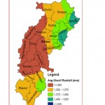 |
Figure 2: Kharif season rainfall variability in Chhattisgarh state Click here to View Figure |
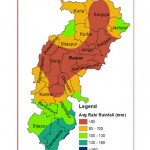 |
Figure 3: Rabi season rainfall variability in Chhattisgarh state Click here to View Figure |
Conclusion
Looking into rainfed rice situation, implication is that our future agricultural planning must take account of rainfall variability and crops and varietal selection as per this variability. Short duration but high yielding varieties need to be developed in this region and brought under cultivation for successful agriculture including weather package as an input. Information generated will be helpful in planning and refinement of crop productivity in rainfed areas of Chhattisgarh. Also another feasible strategy is to alleviate this limitation is to harvest excess rainwater in a farm pond or OFR (On Farm Reservoir) during wet season and use conserved water for crop production in both wet (as insurance against drought) and dry seasons by adopting suitable crop and cropping systems (Rathore et al. 1996). Variability of rainfall has led to the conclusion that rainfall quantity is less in Kawardha, Rajnadgaon and Durg districts and therefore need arises for better water management in eastern zone. Rainfall pattern is determining the suitability of crops and change in cropping pattern accordingly. Further stress has been made to conserve surplus monsoonal rainfall in On Farm Reservoirs (OFR’s) as rainfall is occurring in intense storms and utilize this rainwater for sustainable crop production and also for enhancing cropping intensity. The high potential of OFR’s in alleviating drought and increasing productivity and stability of rainfed ricelands can have significant impacts on rice productivity and other kharif crops too.
References
- Gadagil, Alaka 1986. Annual and weekly analysis of rainfall and temperature for Pune: a multiple time series approach. Inst.Indain Geographers.Vol.8.No.1.1986
- Gupta, S. K., Rao, G. G. S. N. and Rajput, R. K. 1990. Rainfall characteristics and Rain water management strategy for crop production. Mausam 41: 357-264.
- Jagannadha Sarma V.V., 2005.Rainfall pattern in the coastal zone of Krishna Godavary basin Andhra Pradesh India. Journal of applied hydrology.Vol.XVIII.No.1&2 pp111.
- Parthasarthy, B. A.A. Munot and D.R. Kothawale. 1988. Regression model for estimation of India’s foodgrain production from summer monsoon rainfall. Agricultural and Forest Meteorology 42: 167-182.
- Pishroty, P.R. 1987. Water management and watershed management. Wasteland News, 3(1):3-11.
- Rathore, A.L., Pal, A.R., Sahu, R.K. and Chaudhary J.L. 1996. On-farm rainwater and crop management for improving productivity of rainfed areas. Agricultural Watermanagement 31: 253-267 (1996).
- Sikka DR (1977) Some aspects of the life history, structure and movement of monsoon depression, Pageoph. 115, 1501–1529.
- Subramaniam, A.R. and P.A.N. Raju. 1988. Rainfall variability and crop production in south coastal Andhra. Fertilizer News, 33 (4): 39-49.
- Vennila G.2007. Rainfall variation analysis of vattamalaikarai sub basin, Tamil Nadu. Journal of applied hydrology.Vol.XX.No.3. pp.5059


